|
Bradley Junction, Florida
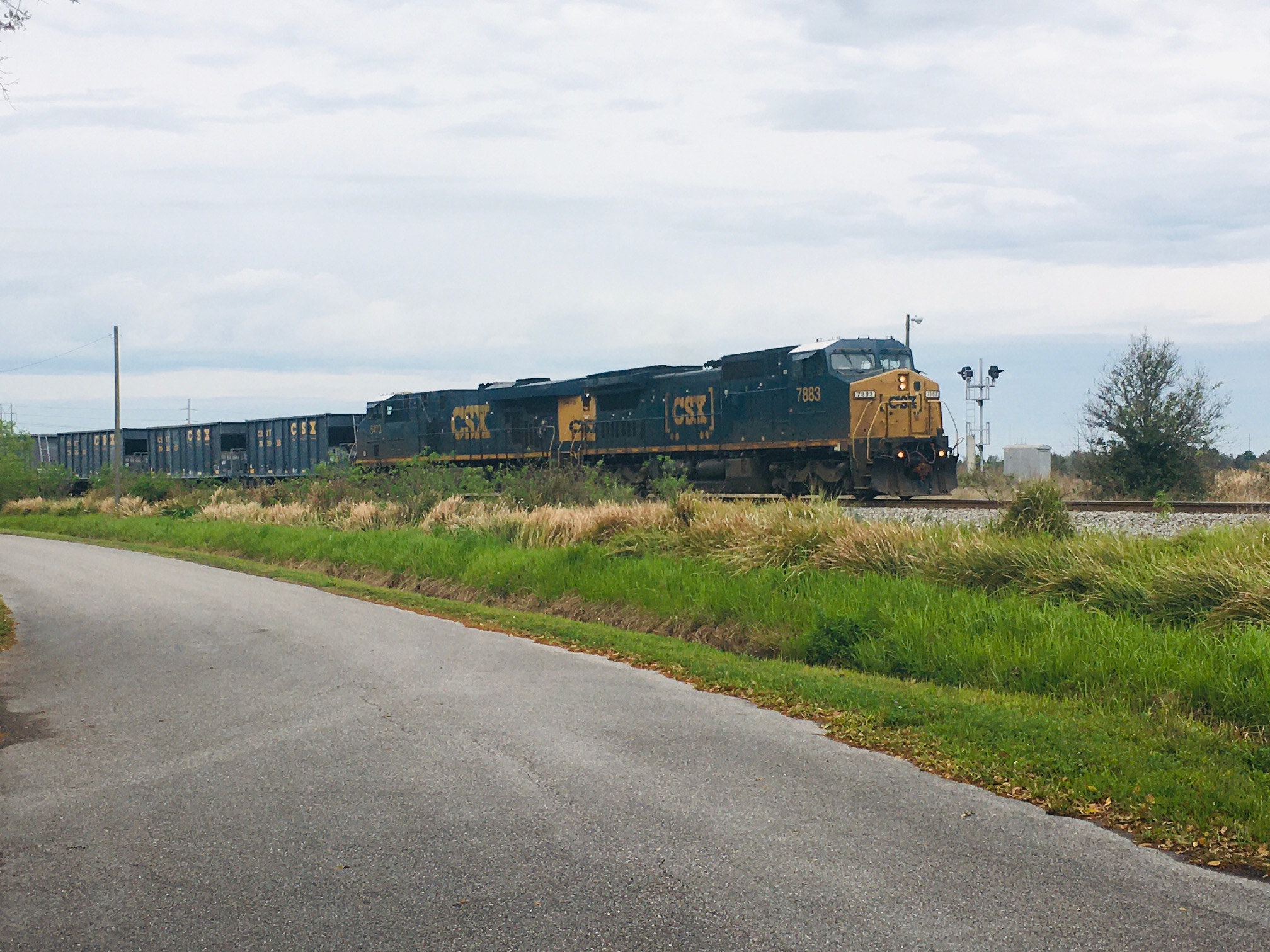
Bradley Junction (also known as Bradley) is an unincorporated community and census-designated place in southwestern Polk County, Florida, United States. Its population was 542 as of the 2020 census. History Bradley Junction is named for the railroad junction located in the community, which was historically the junction between the Seaboard Air Line Railroad (the east-west track) and the Charlotte Harbor and Northern Railway (the north-south track). The junction itself is named after phosphate mining company executive Peter B. Bradley, who chartered the Charlotte Harbor and Northern Railway in 1905. The railroad junction still exists today and both lines are now owned by CSX Transportation. In the mid 1990s, the Florida Gulf Coast Railroad Museum (now the Florida Railroad Museum) moved the railroad station from Bradley Junction to Parrish. The depot was then consumed by a fire soon after the move. Geography Bradley Junction is located at 27.795 degrees north, 81.98056 degrees ... [...More Info...] [...Related Items...] OR: [Wikipedia] [Google] [Baidu] |
Census-designated Place
A census-designated place (CDP) is a concentration of population defined by the United States Census Bureau for statistical purposes only. CDPs have been used in each decennial census since 1980 as the counterparts of incorporated places, such as self-governing cities, towns, and villages, for the purposes of gathering and correlating statistical data. CDPs are populated areas that generally include one officially designated but currently unincorporated community, for which the CDP is named, plus surrounding inhabited countryside of varying dimensions and, occasionally, other, smaller unincorporated communities as well. CDPs include small rural communities, edge cities, colonias located along the Mexico–United States border, and unincorporated resort and retirement communities and their environs. The boundaries of any CDP may change from decade to decade, and the Census Bureau may de-establish a CDP after a period of study, then re-establish it some decades later. Most unin ... [...More Info...] [...Related Items...] OR: [Wikipedia] [Google] [Baidu] |
Unincorporated Communities In Polk County, Florida
Unincorporated may refer to: * Unincorporated area, land not governed by a local municipality * Unincorporated entity, a type of organization * Unincorporated territories of the United States, territories under U.S. jurisdiction, to which Congress has determined that only select parts of the U.S. Constitution apply * Unincorporated association Unincorporated associations are one vehicle for people to cooperate towards a common goal. The range of possible unincorporated associations is nearly limitless, but typical examples are: :* An amateur football team who agree to hire a pitch onc ..., also known as voluntary association, groups organized to accomplish a purpose * ''Unincorporated'' (album), a 2001 album by Earl Harvin Trio {{disambig ... [...More Info...] [...Related Items...] OR: [Wikipedia] [Google] [Baidu] |
Polk County Public Schools
Polk County Public Schools is a school district headquartered in Bartow, Florida, United States. The district serves Polk County. History Civil rights era Before 1965, Polk County maintained two separate school systems, one for white students, and a separate system for non-white students. In 1963, a group of parents of Black students attempted to have their children admitted to the all-white schools. When their applications were denied by the school board, they filed suit in federal district court. In early 1965, a federal judge ordered the schools to formulate a plan to integrate both students and teachers, and provide equal facilities and programs for all students regardless of race. For 1965, the district instituted a sham desegregation plan. In 1969, after additional adverse federal rulings, the district adopted another plan which also proved to be ineffective at integrating the schools. The schools became substantially integrated by 1994. 2020s By October 13, 2021, 17 empl ... [...More Info...] [...Related Items...] OR: [Wikipedia] [Google] [Baidu] |
Sea Level
Mean sea level (MSL, often shortened to sea level) is an average surface level of one or more among Earth's coastal bodies of water from which heights such as elevation may be measured. The global MSL is a type of vertical datuma standardised geodetic datumthat is used, for example, as a chart datum in cartography and marine navigation, or, in aviation, as the standard sea level at which atmospheric pressure is measured to calibrate altitude and, consequently, aircraft flight levels. A common and relatively straightforward mean sea-level standard is instead the midpoint between a mean low and mean high tide at a particular location. Sea levels can be affected by many factors and are known to have varied greatly over geological time scales. Current sea level rise is mainly caused by human-induced climate change. When temperatures rise, Glacier, mountain glaciers and the Ice sheet, polar ice caps melt, increasing the amount of water in water bodies. Because most of human settlem ... [...More Info...] [...Related Items...] OR: [Wikipedia] [Google] [Baidu] |
Elevation
The elevation of a geographic location is its height above or below a fixed reference point, most commonly a reference geoid, a mathematical model of the Earth's sea level as an equipotential gravitational surface (see Geodetic datum § Vertical datum). The term ''elevation'' is mainly used when referring to points on the Earth's surface, while ''altitude'' or ''geopotential height'' is used for points above the surface, such as an aircraft in flight or a spacecraft in orbit, and '' depth'' is used for points below the surface. Elevation is not to be confused with the distance from the center of the Earth. Due to the equatorial bulge, the summits of Mount Everest and Chimborazo have, respectively, the largest elevation and the largest geocentric distance. Aviation In aviation the term elevation or aerodrome elevation is defined by the ICAO as the highest point of the landing area. It is often measured in feet and can be found in approach charts of the aerodrome. It is n ... [...More Info...] [...Related Items...] OR: [Wikipedia] [Google] [Baidu] |
United States Census Bureau
The United States Census Bureau (USCB), officially the Bureau of the Census, is a principal agency of the U.S. Federal Statistical System, responsible for producing data about the American people and economy. The Census Bureau is part of the U.S. Department of Commerce and its director is appointed by the President of the United States. The Census Bureau's primary mission is conducting the U.S. census every ten years, which allocates the seats of the U.S. House of Representatives to the states based on their population. The bureau's various censuses and surveys help allocate over $675 billion in federal funds every year and it assists states, local communities, and businesses make informed decisions. The information provided by the census informs decisions on where to build and maintain schools, hospitals, transportation infrastructure, and police and fire departments. In addition to the decennial census, the Census Bureau continually conducts over 130 surveys and programs ... [...More Info...] [...Related Items...] OR: [Wikipedia] [Google] [Baidu] |
Parrish, Florida
Parrish is an unincorporated community in northwestern Manatee County, Florida, United States. The community is located near the intersection of U.S. 301 and State Road 62 and is part of the North Port–Sarasota–Bradenton Metropolitan Statistical Area. Parrish contains the Florida Railroad Museum, which operates weekend passenger rides round trip from Parrish about northeast to Willow. Climate History The first "settler" in the area would be William B. Hooker and William H. Johnson who established a plantation named Oak Hill in 1850 with an attempt being made to grow sea-island cotton but this effort failed. This plantation would burn down in the Seminole War but the area would continue to be referred to as Oak Hill. William Turner would make a homestead at Oak Hill in 1865 but only stayed for a few years before establishing Bradenton. He would sell the property to the Parish family in 1868. The community was named for Crawford Parrish of Georgia along with h ... [...More Info...] [...Related Items...] OR: [Wikipedia] [Google] [Baidu] |
Florida Railroad Museum
The Florida Railroad Museum is a railroad museum located in Parrish, Florida. The museum operates a heritage railroad and offers round-trip tourist excursions along six miles of the former Seaboard Air Line Sarasota Subdivision in Manatee County between Parrish and Willow. History The museum was founded in 1981 as the Florida Gulf Coast Railroad Museum, and has been operating weekend excursions out of Parrish since 1992. The museum is also active in the ghost town of Willow, where it has maintenance facilities. At Willow, there is a railroad spur that leads east off of the mainline to a Florida Power & Light Company plant. CSX Transportation provides rail service to the plant. The area of Willow is accessible from Willow Road east off of US 301. The museum has a fence around its facilities at Willow and cameras for security. It has constructed a new depot at Willow within this secured property. The railroad line that the Florida Railroad Museum uses is a very small part of a 5 ... [...More Info...] [...Related Items...] OR: [Wikipedia] [Google] [Baidu] |
CSX Transportation
CSX Transportation , known colloquially as simply CSX, is a Class I freight railroad operating in the Eastern United States and the Canadian provinces of Ontario and Quebec. The railroad operates approximately 21,000 route miles () of track. The company operates as the leading subsidiary of CSX Corporation, a Fortune 500 company headquartered in Jacksonville, Florida. CSX Corporation (the parent of CSX Transportation) was formed in 1980 from the merger of Chessie System and Seaboard Coast Line Industries, two holding companies which controlled a number of railroads operating in the Eastern United States. Initially only a holding company itself, the subsidiaries that made up CSX Corporation were gradually merged, with this process completed in 1987. CSX Transportation formally came into existence in 1986, as the successor of Seaboard System Railroad. In 1999, CSX Transportation acquired approximately half of Conrail, in a joint purchase with competitor Norfolk Southern Rai ... [...More Info...] [...Related Items...] OR: [Wikipedia] [Google] [Baidu] |
Charlotte Harbor And Northern Railway
The Charlotte Harbor and Northern Railway is a historic railroad line that at its greatest extent serviced Gasparilla Island in Charlotte Harbor and a major shipping port that once operated there. The railroad's principal purpose was to transport phosphate mined along the Peace River and in the Bone Valley region of Central Florida to the port to be shipped. It also brought passengers to the island community of Boca Grande on Gasparilla Island, and is largely responsible for making Boca Grande the popular tourist destination it is today. Part of the line remains in service today between Mulberry and Arcadia, which is now owned and operated by CSX Transportation. Today, it makes up CSX's Achan Subdivision and part of their Brewster Subdivision. Route At its greatest extent, the Charlotte Harbor and Northern Railway ran from Mulberry to the southern tip of Gasparilla Island, a distance of nearly 100 miles. From Mulberry, the line proceeded south in a mostly straight traje ... [...More Info...] [...Related Items...] OR: [Wikipedia] [Google] [Baidu] |


