|
Braco Airfield
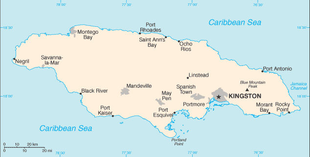
Braco Airfield is a coastal airstrip between Rio Bueno and Duncans in the Trelawny Parish of Jamaica. The airstrip is west of the Meliá Braco Village resort. There are low hills west of the runway. East approach and departure may be over the water. The Sangster VOR/DME (Ident: SIA) is located west of the airstrip. See also * * *Transport in Jamaica Transport in Jamaica consists of roadways, railways, ship and air transport, with roadways forming the backbone of the island's internal transport system. Roadways The Jamaican road network consists of almost 21,000 kilometres of roads, of whi ... * List of airports in Jamaica References External linksOpenStreetMap - Braco Airfield ... [...More Info...] [...Related Items...] OR: [Wikipedia] [Google] [Baidu] |
Rio Bueno, Jamaica
Rio Bueno is a settlement in Jamaica. It has a population of 1,096 as of 2009. Rio Bueno, is a small seaside village on the border between the parishes of St Ann and Trelawny, and owes its importance, history and livelihood to the Rio Bueno Harbour, which is the deepest harbour in Jamaica, and perhaps one of the reasons why Columbus dropped anchor there on his first visit to Jamaica. History The village sprung up during the early days of English Colonialism as a way stop for both maritime and overland visitors, and it traditionally housed taverns, guesthouses and inns. It used the postmark A70 when the post office opened in c. 1859. By the late 19th century the town was almost deserted, a shadow of its former self, but was then resurrected by the construction of a bauxite-shipping wharf in the mid-20th century. The village remains a picturesque gem steeped in history, with its old fort, warehouses and churches set against the water's edge with the green hills of Trelawn ... [...More Info...] [...Related Items...] OR: [Wikipedia] [Google] [Baidu] |
Jamaica
Jamaica (; ) is an island country situated in the Caribbean Sea. Spanning in area, it is the third-largest island of the Greater Antilles and the Caribbean (after Cuba and Hispaniola). Jamaica lies about south of Cuba, and west of Hispaniola (the island containing the countries of Haiti and the Dominican Republic); the British Overseas Territory of the Cayman Islands lies some to the north-west. Originally inhabited by the indigenous Taíno peoples, the island came under Spanish rule following the arrival of Christopher Columbus in 1494. Many of the indigenous people either were killed or died of diseases, after which the Spanish brought large numbers of African slaves to Jamaica as labourers. The island remained a possession of Spain until 1655, when England (later Great Britain) conquered it, renaming it ''Jamaica''. Under British colonial rule Jamaica became a leading sugar exporter, with a plantation economy dependent on the African slaves and later their des ... [...More Info...] [...Related Items...] OR: [Wikipedia] [Google] [Baidu] |
Airstrip
An aerodrome (Commonwealth English) or airdrome (American English) is a location from which aircraft flight operations take place, regardless of whether they involve air cargo, passengers, or neither, and regardless of whether it is for public or private use. Aerodromes include small general aviation airfields, large commercial airports, and military air bases. The term ''airport'' may imply a certain stature (having satisfied certain certification criteria or regulatory requirements) that not all aerodromes may have achieved. That means that all airports are aerodromes, but not all aerodromes are airports. Usage of the term "aerodrome" remains more common in Ireland and Commonwealth nations, and is conversely almost unknown in American English, where the term "airport" is applied almost exclusively. A water aerodrome is an area of open water used regularly by seaplanes, floatplanes or amphibious aircraft for landing and taking off. In formal terminology, as defined by th ... [...More Info...] [...Related Items...] OR: [Wikipedia] [Google] [Baidu] |
Duncans
Duncans is a settlement in Jamaica Jamaica (; ) is an island country situated in the Caribbean Sea. Spanning in area, it is the third-largest island of the Greater Antilles and the Caribbean (after Cuba and Hispaniola). Jamaica lies about south of Cuba, and west of His .... References Populated places in Trelawny Parish {{Jamaica-geo-stub ... [...More Info...] [...Related Items...] OR: [Wikipedia] [Google] [Baidu] |
Trelawny Parish
Trelawny (Jamaican Patois: ''Trilaani'' or ''Chrilaani'') is a parish in the county of Cornwall in northwest Jamaica. Its capital is Falmouth. It is bordered by the parishes of Saint Ann in the east, Saint James in the west, and Saint Elizabeth and Manchester in the south. Trelawny is known for producing several Olympic sprinters. History In 1770, the wealthy planters in St James and St Ann succeeded in having sections of those parishes become the parish of Trelawny as they were too far from administrative centres. Trelawny was named after Sir William Trelawny, 6th Baronet, the then Governor of Jamaica, whose prominent family had originated at the manor of Trelawny in the parish of Pelynt in Cornwall, England. The first capital was Martha Brae, located inland from Rock Bay. Trelawny is best known for its sugar estates and sugar cane mills. It had more sugar estates than any other parish, so there was need for a sea coast town to export it. Falmouth became a thrivi ... [...More Info...] [...Related Items...] OR: [Wikipedia] [Google] [Baidu] |
VOR/DME
In radio navigation, a VOR/DME is a radio beacon that combines a VHF omnidirectional range (VOR) with a distance-measuring equipment (DME). The VOR allows the receiver to measure its bearing to or from the beacon, while the DME provides the slant distance between the receiver and the station. Together, the two measurements allow the receiver to compute a position fix. The VOR system was first introduced in the 1930s, but didn't enter significant commercial use until the early 1950s. It became much more practical with the introduction of low-cost Solid state (electronics), solid state receivers in the 1960s. DME was a modification of World War II-era navigation systems like Gee-H, and began development in 1946. Like VOR, it only became practical with the introduction of solid state receivers during the 1960s. During the mid-1960s, ICAO began the process of introducing a standardized radio navigation system for medium-area coverage on the order of a few hundred kilometres. This ... [...More Info...] [...Related Items...] OR: [Wikipedia] [Google] [Baidu] |
Transport In Jamaica
Transport in Jamaica consists of roadways, railways, ship and air transport, with roadways forming the backbone of the island's internal transport system. Roadways The Jamaican road network consists of almost 21,000 kilometres of roads, of which over 15,000 kilometres are paved.The CIA World Factbook - Jamaica Retrieved June 27, 2007 The Jamaican Government has, since the late 1990s and in cooperation with private investors, embarked on a campaign of infrastructural improvement projects, one of which includes the creation of a system of s, the first such access-controlled roadwa ... [...More Info...] [...Related Items...] OR: [Wikipedia] [Google] [Baidu] |
List Of Airports In Jamaica
This is a list of airports in Jamaica, grouped by type and sorted by location. List of airports by name Names shown in bold indicate the airport has scheduled passenger service on commercial airlines. See also * Transport in Jamaica * List of airports by ICAO code: M#MK - Jamaica * Wikipedia: WikiProject Aviation/Airline destination lists: North America#Jamaica References Airports Authority of JamaicaJamaica Civil Aviation Authority* , contains list of aerodromes in Jamaica * * - includes IATA codes Great Circle Mapper: Airports in Jamaica reference for airport codes World Aero Data: Airports in Jamaica reference for coordinates Footnotes {{North America topic, List of airports in Jamaica Airports Airports Jamaica Jamaica (; ) is an island country situated in the Caribbean Sea. Spanning in area, it is the third-largest island of the Greater Antilles and the Caribbean (after Cuba and Hispaniola). Jamaica lies about south of Cuba, and west ... [...More Info...] [...Related Items...] OR: [Wikipedia] [Google] [Baidu] |

.jpg)

