|
Borders Of Akrotiri And Dhekelia
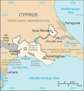
The borders of Akrotiri and Dhekelia refer to the international boundary between the Sovereign Base Areas of Akrotiri and Dhekelia (a British overseas territory) and the republic of Cyprus. The SBAs consist of two enclaves in the island of Cyprus. The border of Akrotiri is , and the border of Dhekelia is . Dhekelia is also bound by the UN Buffer Zone and the unrecognised state in Northern Cyprus. History Customs and identity checks Possession of a passport, or an EU compliant national identity card is generally needed in Cyprus. There is no "hard" land border with Cyprus, and entry to the public areas of both SBAs can be done without any difficulty. In the exchange of notes establishing them the British government specifically stated that it would not, "...create customs posts or other frontier barriers between the Sovereign Base Areas and the Republic." More formal controls do exist at the Republic of Northern Cyprus boundary. A passport is required to tra ... [...More Info...] [...Related Items...] OR: [Wikipedia] [Google] [Baidu] |
Akrotiri And Dhekelia
Akrotiri and Dhekelia, officially the Sovereign Base Areas of Akrotiri and Dhekelia (SBA),, ''Periochés Kyríarchon Váseon Akrotiríou ke Dekélias''; tr, Ağrotur ve Dikelya İngiliz Egemen Üs Bölgeleri is a British Overseas Territory on the island of Cyprus. The areas, which include British military bases and installations, as well as other land, were retained by the British under the 1960 treaty of independence, signed by the United Kingdom, Greece, Turkey and representatives from the Greek and Turkish Cypriot communities, which granted independence to the (then) Crown colony of Cyprus. The territory serves an important role as a station for signals intelligence and provides a vital strategic part of the United Kingdom surveillance-gathering network in the Mediterranean and the Middle East. History The Sovereign Base Areas were created in 1960 by the London and Zürich Agreements, when Cyprus achieved independence from the British Empire, as recorded by the Unite ... [...More Info...] [...Related Items...] OR: [Wikipedia] [Google] [Baidu] |
Flag Of The United Nations
The flag of the United Nations consists of the emblem depicting the white azimuthal equidistant projection of the world map, centred on the North Pole, with two white olive branches placed on to its right and left, located on the sky blue background. The emblem was officially adopted on 7 December 1946, and the flag, on 20 October 1947. Design The flag of the United Nations consists of the white emblem on the sky blue background. The emblem depicts a azimuthal equidistant projection of the world map, centred on the North Pole, with the globe being bisected in the centre by the Prime meridian and the International Date Line, thus ensuring that no country is at prominence within the flag. The projection of the map extends to 60 degrees south latitude, and includes five concentric circles. The map is inscribed in a wreath consisting of crossed conventionalized Olive branch, branches of the olive tree. The size of the emblem on the flag is one half the width of the flag itself. T ... [...More Info...] [...Related Items...] OR: [Wikipedia] [Google] [Baidu] |
United Nations Buffer Zone In Cyprus
The United Nations Buffer Zone in Cyprus is a demilitarized zone, patrolled by the United Nations Peacekeeping Force in Cyprus (UNFICYP), that was established in 1964 and extended in 1974 after the ceasefire of 16 August 1974, following the Turkish invasion of Cyprus, and the ''de facto'' partition of the island into the area controlled by the Republic of Cyprus (excluding the British Sovereign Base Areas) and the largely unrecognized Turkish Republic of Northern Cyprus in the north. The zone, also known as the Green Line (, ''Prasini Grammi''; ), stretches for from Paralimni in the east to Kato Pyrgos in the west, where a separate section surrounds Kokkina. The dividing line is also referred to as the Attila Line, named after Turkey's 1974 military intervention, codenamed ''Operation Attila''. The Turkish army has built a barrier on the zone's northern side, consisting mainly of barbed-wire fencing, concrete wall segments, watchtowers, anti-tank ditches, and minefields. The ... [...More Info...] [...Related Items...] OR: [Wikipedia] [Google] [Baidu] |
Border
Borders are usually defined as geographical boundaries, imposed either by features such as oceans and terrain, or by political entities such as governments, sovereign states, federated states, and other subnational entities. Political borders can be established through warfare, colonization, or mutual agreements between the political entities that reside in those areas; the creation of these agreements is called boundary delimitation. Some borders—such as most states' internal administrative borders, or inter-state borders within the Schengen Area—are open and completely unguarded. Most external political borders are partially or fully controlled, and may be crossed legally only at designated border checkpoints; adjacent border zones may also be controlled. Buffer zones may be setup on borders between belligerent entities to lower the risk of escalation. While ''border'' refers to the boundary itself, the area around the border is called the frontier. History In the ... [...More Info...] [...Related Items...] OR: [Wikipedia] [Google] [Baidu] |
Sovereign Base Areas
Akrotiri and Dhekelia, officially the Sovereign Base Areas of Akrotiri and Dhekelia (SBA),, ''Periochés Kyríarchon Váseon Akrotiríou ke Dekélias''; tr, Ağrotur ve Dikelya İngiliz Egemen Üs Bölgeleri is a British Overseas Territory on the island of Cyprus. The areas, which include British military bases and installations, as well as other land, were retained by the British under the 1960 treaty of independence, signed by the United Kingdom, Greece, Turkey and representatives from the Greek and Turkish Cypriot communities, which granted independence to the (then) Crown colony of Cyprus. The territory serves an important role as a station for signals intelligence and provides a vital strategic part of the United Kingdom surveillance-gathering network in the Mediterranean and the Middle East. History The Sovereign Base Areas were created in 1960 by the London and Zürich Agreements, when Cyprus achieved independence from the British Empire, as recorded by the Unite ... [...More Info...] [...Related Items...] OR: [Wikipedia] [Google] [Baidu] |
British Overseas Territory
The British Overseas Territories (BOTs), also known as the United Kingdom Overseas Territories (UKOTs), are fourteen dependent territory, territories with a constitutional and historical link with the United Kingdom. They are the last remnants of the former British Empire and do not form part of the United Kingdom itself. The permanently inhabited territories are internally Self-governance, self-governing, with the United Kingdom retaining responsibility for Defence (military), defence and foreign relations. Three of the territories are inhabited only by a transitory population of military or scientific personnel. All but one of the rest are listed by the Special Committee on Decolonization, UN Special Committee on Decolonization as United Nations list of non-self-governing territories, non-self-governing territories. All fourteen have the Monarchy of the United Kingdom, British monarch as head of state. three territories (the Falkland Islands, Gibraltar and the Akrotiri an ... [...More Info...] [...Related Items...] OR: [Wikipedia] [Google] [Baidu] |
Cyprus
Cyprus ; tr, Kıbrıs (), officially the Republic of Cyprus,, , lit: Republic of Cyprus is an island country located south of the Anatolian Peninsula in the eastern Mediterranean Sea. Its continental position is disputed; while it is geographically in Western Asia, its cultural ties and geopolitics are overwhelmingly Southern European. Cyprus is the third-largest and third-most populous island in the Mediterranean. It is located north of Egypt, east of Greece, south of Turkey, and west of Lebanon and Syria. Its capital and largest city is Nicosia. The northeast portion of the island is ''de facto'' governed by the self-declared Turkish Republic of Northern Cyprus, which was established after the 1974 invasion and which is recognised as a country only by Turkey. The earliest known human activity on the island dates to around the 10th millennium BC. Archaeological remains include the well-preserved ruins from the Hellenistic period such as Salamis and Kourion, and Cypr ... [...More Info...] [...Related Items...] OR: [Wikipedia] [Google] [Baidu] |
Akrotiri (village)
Akrotiri ( gr, Ακρωτήρι, literally ''Cape'', tr, Ağrotur) is a village within the Akrotiri Sovereign Base Area, which forms part of the British Overseas Territory of Akrotiri and Dhekelia. It is the only village in the Western SBA with a significant non-military population. The village contains two small churches dedicated to St. Cross and St. George. To the south is a site called Kourion (Greek: Κούριον) containing the ruins of an ancient settlement. Of the place Stefano Lusignan in his ''Description de toute l'isle de Cypre'' (Paris, 1580) says: "Cury est une ville antique, située au milieu du Promontoire des chats." ("Kouria is an ancient town situated in the middle of the Headland of Cats.") Administration When the Sovereign Base Area was created, those living in Akrotiri were paid to allow them to move elsewhere. However, villagers argued that while the compensation assessed their housing, it did not account for their fields, and thus they were unable to ... [...More Info...] [...Related Items...] OR: [Wikipedia] [Google] [Baidu] |
Dhekelia
Dhekelia Cantonment ( el, Φρουρά Δεκέλεια, tr, Dikelya Cantonment) is a military base in Akrotiri and Dhekelia, a British Overseas Territory on the island of Cyprus, administered as the Sovereign Base Areas. It is located in the Eastern Sovereign Base Area, one of the two areas which comprise the territory. It is the larger of the British military bases on the island, and it is also the location of Alexander Barracks, which is home to 2nd Battalion, The Princess of Wales's Royal Regiment. In autumn 2017 the 2nd Battalion Royal Anglian Regiment deployed to Dhekelia replacing 2nd Battalion, The Princess of Wales's Royal Regiment. It forms a part of British Forces Cyprus. The eastern part of the cantonment includes Ayios Nikolaos Station and a Green Line crossing point. The western part includes several Greek Cypriot enclaves including Xylotymbou, Ormidhia and Dhekelia Power Station. The two parts of the cantonment are joined by a narrow corridor little wider tha ... [...More Info...] [...Related Items...] OR: [Wikipedia] [Google] [Baidu] |
Northern Cyprus
Northern Cyprus ( tr, Kuzey Kıbrıs), officially the Turkish Republic of Northern Cyprus (TRNC; tr, Kuzey Kıbrıs Türk Cumhuriyeti, ''KKTC''), is a ''de facto'' state that comprises the northeastern portion of the Geography of Cyprus, island of Cyprus. List of states with limited recognition, Recognised only by Turkey, Northern Cyprus is considered by the international community to be part of the Cyprus, Republic of Cyprus. Northern Cyprus extends from Cape Apostolos Andreas, the tip of the Karpass Peninsula in the northeast to Morphou Bay, Cape Kormakitis and its westernmost point, the Kokkina exclave in the west. Its southernmost point is the village of Louroujina. A United Nations Buffer Zone in Cyprus, buffer zone under the control of the United Nations stretches between Northern Cyprus and the rest of the island and divides Nicosia, the island's largest city and capital of both sides. A 1974 Cypriot coup d'état, coup d'état in 1974, performed as part of an attempt ... [...More Info...] [...Related Items...] OR: [Wikipedia] [Google] [Baidu] |


