|
Blåmannsisen
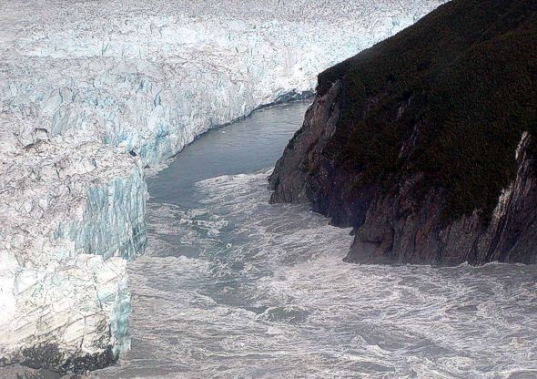
or ( en, Blåmann Glacier) is the fifth-largest glacier in mainland Norway. It is located on the border of the municipalities of Fauske and Sørfold in Nordland county, Norway—just west of the border with Sweden. Its highest point is above sea level and its lowest point is at an elevation of . Three outlet glaciers extend from the icecap. A small outlet spills over a subglacial ridge to the north damming an unnamed lake resulting in occasion outburst floods. To the east a large outlet extends towards the lake, Leirvatnet. A further outlet descends steeply to the west. The western and northern outlets are heavily crevassed, as is the snout of the eastern glacier calving into Leirvatnet. The glacier also calves into lake Blåmannsisvatnet, resulting in extensive crevasses in the glacier above that lake. Given the degree of crevassing at the margins, traversing the glacier can be dangerous, particularly in late spring or early summer when snow bridges may be weak. Blåm ... [...More Info...] [...Related Items...] OR: [Wikipedia] [Google] [Baidu] |
Fauske
or is a municipality located in Nordland county, Norway. It is part of the traditional district of Salten. The administrative centre of the municipality is the town of Fauske. Some of the villages in Fauske include Nystad, Venset, Straumsnes, and Sulitjelma. The municipality borders Sweden in the east and the municipalities of Sørfold to the north, Bodø to the west, and Saltdal to the southeast. The town is located on the northern shore of Skjerstad Fjord. The municipality is the 90th largest by area out of the 356 municipalities in Norway. Fauske is the 117th most populous municipality in Norway with a population of 9,603. The municipality's population density is and its population has increased by 0.9% over the previous 10-year period. General information The municipality was established on 1 January 1905 when the municipality of Skjerstad was divided into Skjerstad (population: 1,709) in the west and Fauske (population: 4,646) in the east. The municipal borders hav ... [...More Info...] [...Related Items...] OR: [Wikipedia] [Google] [Baidu] |
Sørfold
Sørfold is a municipality in Nordland county, Norway. It is part of the traditional district of Salten. The administrative centre of the municipality is the village of Straumen. Other villages in the municipality include Leirfjordgården, Mørsvikbotn, Røsvika, Rørstad, Styrkesvik, and Øvre Kvarv. The municipality surrounds the Sørfolda fjord and stretches east to the border with Sweden. The municipality is the 48th largest by area out of the 356 municipalities in Norway. Sørfold is the 286th most populous municipality in Norway with a population of 1,869. The municipality's population density is and its population has decreased by 6.7% over the previous 10-year period. General information The municipality of ''Sørfolden'' was established on 1 January 1887 when the old municipality of Folden was divided into two: Sørfolden (population: 1,946) and Nordfold-Kjerringøy (population: 1,347). The spelling was later changed to just ''Sørfold''. On 1 Januar ... [...More Info...] [...Related Items...] OR: [Wikipedia] [Google] [Baidu] |
Nordland
Nordland (; smj, Nordlánnda, sma, Nordlaante, sme, Nordlánda, en, Northland) is a county in Norway in the Northern Norway region, the least populous of all 11 counties, bordering Troms og Finnmark in the north, Trøndelag in the south, Norrbotten County in Sweden to the east, Västerbotten County to the south-east, and the Atlantic Ocean (Norwegian Sea) to the west. The county was formerly known as ''Nordlandene amt''. The county administration is in the town of Bodø. The remote Arctic island of Jan Mayen has been administered from Nordland since 1995. In the southern part of the county is Vega, listed on the UNESCO World Heritage Site list. Districts The county is divided into traditional districts. These are Helgeland in the south (south of the Arctic Circle), Salten in the centre, and Ofoten in the north-east. In the north-west lie the archipelagoes of Lofoten and Vesterålen. Geography Nordland is located along the northwestern coast of the Scandinavian pe ... [...More Info...] [...Related Items...] OR: [Wikipedia] [Google] [Baidu] |
Leirvatnet (Sørfold)
Leirvatnet is a lake located on the border between Norway and Sweden. The majority of the lake lies in Sørfold Municipality in Nordland county, Norway, and the remaining of the lake are located in Jokkmokk Municipality in Norrbotten County, Sweden. The lake lies at one end of the large Blåmannsisen glacier. See also * List of lakes in Norway * Geography of Norway Norway is a country located in Northern Europe in the northern and western parts of the Scandinavian Peninsula. The majority of the country borders water, including the Skagerrak inlet to the south, the North Sea to the southwest, the North Atla ... References Sørfold Lakes of Nordland Lakes of Norrbotten County Norway–Sweden border International lakes of Europe {{Norrbotten-geo-stub ... [...More Info...] [...Related Items...] OR: [Wikipedia] [Google] [Baidu] |
Blåmannsisvatnet
Blåmannsisvatnet is a lake in Fauske Municipality in Nordland county, Norway. The lake lies on the southeast edge of the large Blåmannsisen or ( en, Blåmann Glacier) is the fifth-largest glacier in mainland Norway. It is located on the border of the municipalities of Fauske and Sørfold in Nordland county, Norway—just west of the border with Sweden. Its highest point is ... glacier, about east of the town of Fauske. The border with Sweden is located about east of the lake. See also * List of lakes in Norway * Geography of Norway References Lakes of Nordland Fauske {{Nordland-lake-stub ... [...More Info...] [...Related Items...] OR: [Wikipedia] [Google] [Baidu] |
List Of Glaciers In Norway
These are the largest glaciers on mainland Norway.The largest glaciers in Norway (page 51, Accessed on July 29, 2014) However, the 18 largest glaciers in the are on , including the second largest in Europe, on |
Norway
Norway, officially the Kingdom of Norway, is a Nordic country in Northern Europe, the mainland territory of which comprises the western and northernmost portion of the Scandinavian Peninsula. The remote Arctic island of Jan Mayen and the archipelago of Svalbard also form part of Norway. Bouvet Island, located in the Subantarctic, is a dependency of Norway; it also lays claims to the Antarctic territories of Peter I Island and Queen Maud Land. The capital and largest city in Norway is Oslo. Norway has a total area of and had a population of 5,425,270 in January 2022. The country shares a long eastern border with Sweden at a length of . It is bordered by Finland and Russia to the northeast and the Skagerrak strait to the south, on the other side of which are Denmark and the United Kingdom. Norway has an extensive coastline, facing the North Atlantic Ocean and the Barents Sea. The maritime influence dominates Norway's climate, with mild lowland temperatures on the se ... [...More Info...] [...Related Items...] OR: [Wikipedia] [Google] [Baidu] |
Sweden
Sweden, formally the Kingdom of Sweden,The United Nations Group of Experts on Geographical Names states that the country's formal name is the Kingdom of SwedenUNGEGN World Geographical Names, Sweden./ref> is a Nordic country located on the Scandinavian Peninsula in Northern Europe. It borders Norway to the west and north, Finland to the east, and is connected to Denmark in the southwest by a bridgetunnel across the Öresund. At , Sweden is the largest Nordic country, the third-largest country in the European Union, and the fifth-largest country in Europe. The capital and largest city is Stockholm. Sweden has a total population of 10.5 million, and a low population density of , with around 87% of Swedes residing in urban areas in the central and southern half of the country. Sweden has a nature dominated by forests and a large amount of lakes, including some of the largest in Europe. Many long rivers run from the Scandes range through the landscape, primarily ... [...More Info...] [...Related Items...] OR: [Wikipedia] [Google] [Baidu] |
Luleälv
Lule River ( smj, Julevädno, sv, Lule älv, ''Luleälven'') is a major river in Sweden, rising in northern Sweden and flowing southeast for before reaching the Gulf of Bothnia at Luleå. It is the second longest river by watershed area or length in Norrbotten County (after the Torne River and very slightly ahead of the Kalix River, which is 460.65 km long), but is the largest by average discharge. It has a watershed of 25,240.5 km² of which 24,545.6 km² is in Sweden and 694.9 km² in Norway. The river is an important source of hydroelectric energy, with major hydroelectric plants at e.g. Porjus and the 977 MW Harsprånget, commissioned in 1952 and expanded in 1983 to become Sweden's largest hydro power station.Mellgren, Erik"Third time counted for Harsprånget" ''Ny Teknik'' 28 July 2012. Retrieved: 7 August 2012. The river was used extensively for the transportation of timber, with logs floated downstream for processing at Luleå, but this stopped ... [...More Info...] [...Related Items...] OR: [Wikipedia] [Google] [Baidu] |
Jökulhlaup
A jökulhlaup ( ) (literally "glacial run") is a type of glacial outburst flood. It is an Icelandic term that has been adopted in glaciological terminology in many languages. It originally referred to the well-known subglacial outburst floods from Vatnajökull, Iceland, which are triggered by geothermal heating and occasionally by a volcanic subglacial eruption, but it is now used to describe any large and abrupt release of water from a subglacial or proglacial lake/reservoir. Since jökulhlaups emerge from hydrostatically sealed lakes with floating levels far above the threshold, their peak discharge can be much larger than that of a marginal or extra-marginal lake burst. The hydrograph of a jökulhlaup from Vatnajökull typically either climbs over a period of weeks with the largest flow near the end, or it climbs much faster during the course of some hours. These patterns are suggested to reflect channel melting, and sheet flow under the front, respectively. Similar pr ... [...More Info...] [...Related Items...] OR: [Wikipedia] [Google] [Baidu] |
Equilibrium Line Altitude
Glaciology (; ) is the scientific study of glaciers, or more generally ice and natural phenomena that involve ice. Glaciology is an interdisciplinary Earth science that integrates geophysics, geology, physical geography, geomorphology, climatology, meteorology, hydrology, biology, and ecology. The impact of glaciers on people includes the fields of human geography and anthropology. The discoveries of water ice on the Moon, Mars, Europa and Pluto add an extraterrestrial component to the field, which is referred to as "astroglaciology". Overview A glacier is an extended mass of ice formed from snow falling and accumulating over a long period of time; glaciers move very slowly, either descending from high mountains, as in valley glaciers, or moving outward from centers of accumulation, as in continental glaciers. Areas of study within glaciology include glacial history and the reconstruction of past glaciation. A glaciologist is a person who studies glaciers. A glacial geolog ... [...More Info...] [...Related Items...] OR: [Wikipedia] [Google] [Baidu] |
Firn
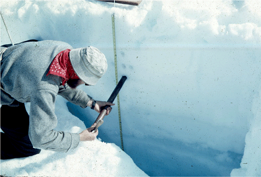
__NOTOC__ Firn (; from Swiss German "last year's", cognate with ''before'') is partially compacted névé, a type of snow that has been left over from past seasons and has been recrystallized into a substance denser than névé. It is ice that is at an intermediate stage between snow and glacial ice. Firn has the appearance of wet sugar, but has a hardness that makes it extremely resistant to shovelling. Its density generally ranges from 0.35 g/cm3 to 0.9 g/cm3, and it can often be found underneath the snow that accumulates at the head of a glacier. Snowflakes are compressed under the weight of the overlying snowpack. Individual crystals near the melting point are semiliquid and slick, allowing them to glide along other crystal planes and to fill in the spaces between them, increasing the ice's density. Where the crystals touch they bond together, squeezing the air between them to the surface or into bubbles. In the summer months, the crystal metamorphosis can occur ... [...More Info...] [...Related Items...] OR: [Wikipedia] [Google] [Baidu] |


