|
Biosphere Reserves Of Iran
The biosphere reserves of Iran have a total land area of 1.64 million km2. They support more than 8,000 recorded species of plants (almost 2,421 are endemic), 502 species of birds, 164 species of mammals, 209 species of reptiles, and 375 species of butterflies. Iran has taken many steps to protect its natural resources, biodiversity, and landscapes. The country has established national parkss, natural monuments, wildlife sanctuaries, and protected areas. The country has also identified and registered 13 areas as biosphere reserves since 1976. List * Arasbaran, 1976 * Arjan Protected Area and Lake Parishan, 1976 * Geno, 1976 * Golestan, 1976 * Hara, 1976 * Kavir, 1977 * Lake Oromeeh, 1976 * Miankaleh, 1976 * Touran, 1976 * Dena, 2010 * Tang-e-Sayad & Sabzkuh, 2015 * Hamoun, 2016 * Kopet Dag, 2018 See also * Geography of Iran * Iranian Plateau The Iranian plateau or Persian plateau is a geological feature in Western Asia, Central Asia, and South Asia. It comp ... [...More Info...] [...Related Items...] OR: [Wikipedia] [Google] [Baidu] |
Endemism
Endemism is the state of a species being found in a single defined geographic location, such as an island, state, nation, country or other defined zone; organisms that are indigenous to a place are not endemic to it if they are also found elsewhere. For example, the Cape sugarbird is found exclusively in southwestern South Africa and is therefore said to be ''endemic'' to that particular part of the world. An endemic species can be also be referred to as an ''endemism'' or in scientific literature as an ''endemite''. For example ''Cytisus aeolicus'' is an endemite of the Italian flora. ''Adzharia renschi'' was once believed to be an endemite of the Caucasus, but it was later discovered to be a non-indigenous species from South America belonging to a different genus. The extreme opposite of an endemic species is one with a cosmopolitan distribution, having a global or widespread range. A rare alternative term for a species that is endemic is "precinctive", which applies t ... [...More Info...] [...Related Items...] OR: [Wikipedia] [Google] [Baidu] |
Mangrove Forests Of Qeshm
The Mangrove forests of Qeshm or Hara forests of Qeshm, are the mangrove forests on the southern coast of Iran, particularly on and near the island of Qeshm in the Persian Gulf. Dominated by the species ''Avicennia marina'', known locally as the "hara" or "harra" tree, the forests represent an important ecological resource. The "Hara Protected Area" on Quesm and the nearby mainland is a biosphere reserve where commercial use is restricted to fishing (mainly shrimp), tourist boat trips, and limited mangrove cutting for animal feed. Hara tree characteristics The hara tree, ''Avicennia marina'', grows to heights of three to eight meters and has bright green leaves and twigs. The tree is a salt-water plant that is often submerged at high tide. It usually blossoms and bears fruit from mid-July to August, with yellow flowers and a sweet almond-like fruit. The seeds fall into the water, where wave action takes them to more stationary parts of the sea. The hara seeds become fixed in ... [...More Info...] [...Related Items...] OR: [Wikipedia] [Google] [Baidu] |
List Of National Parks And Protected Areas Of Iran
The National parks and protected areas, and wildlife refuges, of Iransepehr Listings There are around 200 protected areas in Iran to preserve the precious biodiversity of this country and there are about 16 National Parks among them that are home to some of our planet’s most incredible species. Golestan National Park, Kavir National Park, Turan National Park, and Tandoureh National Park are among the top protected areas. Each of these parks encompasses exceptional and unique varieties of flora and fauna in their wild frontiers. Notice that all National Parks of Iran are safe to visit but you need a permit to enter any of the National Parks and it’s best to take a tour leader or a ranger with yourself to get close to any of the wild animals you like to see. The complete national parks, protected areas, and wildlife refuges in Iran include: National Parks * Bakhtegan National Park *Bamu National Park — ''near Shiraz'' * Bojagh National Park * Dayer-Nakhiloo National Park ... [...More Info...] [...Related Items...] OR: [Wikipedia] [Google] [Baidu] |
Iranian Plateau
The Iranian plateau or Persian plateau is a geological feature in Western Asia, Central Asia, and South Asia. It comprises part of the Eurasian Plate and is wedged between the Arabian Plate and the Indian Plate; situated between the Zagros Mountains to the west, the Caspian Sea and the Köpet Dag to the north, the Armenian Highlands and the Caucasus Mountains to the northwest, the Strait of Hormuz and the Persian Gulf to the south, and the Indian subcontinent to the east. As a historical region, it includes Parthia, Media, Persis, and some of the previous territories of Greater Iran."Old Iranian Online" University of Texas College of Liberal Arts (retrieved 10 February 2007) The Zagros form the plateau's western boundary, and its eastern slopes may also be included in the term. The '' |
Geography Of Iran
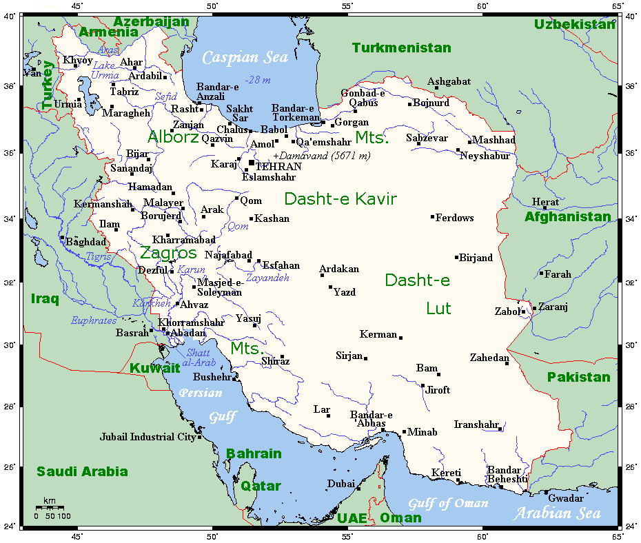
Geographically, the country of Iran is located in West Asia and borders the Caspian Sea, Persian Gulf, and Gulf of Oman. Topographically, it is predominantly located on the Persian Plateau. Its mountains have impacted both the political and the economic history of the country for several centuries. The mountains enclose several broad basins, on which major agricultural and urban settlements are located. Until the 20th century, when major highways and railroads were constructed through the mountains to connect the population centers, these basins tended to be relatively isolated from one another. Typically, one major town dominated each basin, and there were complex economic relationships between the town and the hundreds of villages that surrounded it. In the higher elevations of the mountains rimming the basins, tribally organized groups practiced transhumance, moving with their herds of sheep and goats between traditionally established summer and winter pastures. There are ... [...More Info...] [...Related Items...] OR: [Wikipedia] [Google] [Baidu] |
Kopet Dag
The Köpet Dag, Kopet Dagh, or Koppeh Dagh ( tk, Köpetdag; fa, کپهداغ), also known as the Turkmen-Khorasan Mountain Range, is a mountain range on the border between Turkmenistan and Iran that extends about along the border southeast of the Caspian Sea, stretching northwest-southeast from near the Caspian Sea in the northwest to the Harirud River in the southeast. In the southwest it borders on the parallel eastern endings of the Alborz mountains being together part of the much larger Alpide belt. The highest peak of the range in Turkmenistan is the Mount Rizeh (Kuh-e Rizeh), located at the southwest of the capital Ashgabat and stands at . The highest Iranian summit is Mount Quchan (Kuh-e Quchan) with . Etymology Vambery conjectured that ''köpet'' originates from the Turkmen language where "köp" means "a lot" or "many" and the word "dag" means "mountain" or "peak". He thus translated Köpetdag as "Many mountains (peaks)". He and others noted that in Persian ''koppeh ... [...More Info...] [...Related Items...] OR: [Wikipedia] [Google] [Baidu] |
Hamun Lake
Lake Hāmūn ( fa, دریاچه هامون, ''Daryācheh-ye Hāmūn''; ps, هامون ډنډ), or the Hamoun Oasis, is a seasonal lake and wetlands in the endorheic Sīstān Basin in the Sistan region on the Afghanistan–Iran border. In Iran, it is also known as ''Hāmūn-e Helmand'', ''Hāmūn-e Hīrmand'', or ''Daryācheh-ye Sīstān'' ("Lake Sīstān"). '' Hāmūn'' is a generic term which refers to shallow lakes (or lagoons), usually seasonal, that occur in the deserts of southeast Iran and adjacent areas of Afghanistan and Pakistan as a product of snowmelt in nearby mountains in spring. The term Hāmūn Lake (or Lake Hāmūn) is equally applied to ''Hāmūn-e Helmand'' (entirely in Iran), as well to the shallow lakes Hāmūn-e Sabari and Hāmūn-e Puzak, which extend into the territory of present-day Afghanistan with latter being almost entirely inside Afghanistan. The Hamun is fed by numerous seasonal water tributaries; the main tributary is the perennial Helmand River, ... [...More Info...] [...Related Items...] OR: [Wikipedia] [Google] [Baidu] |
Dena
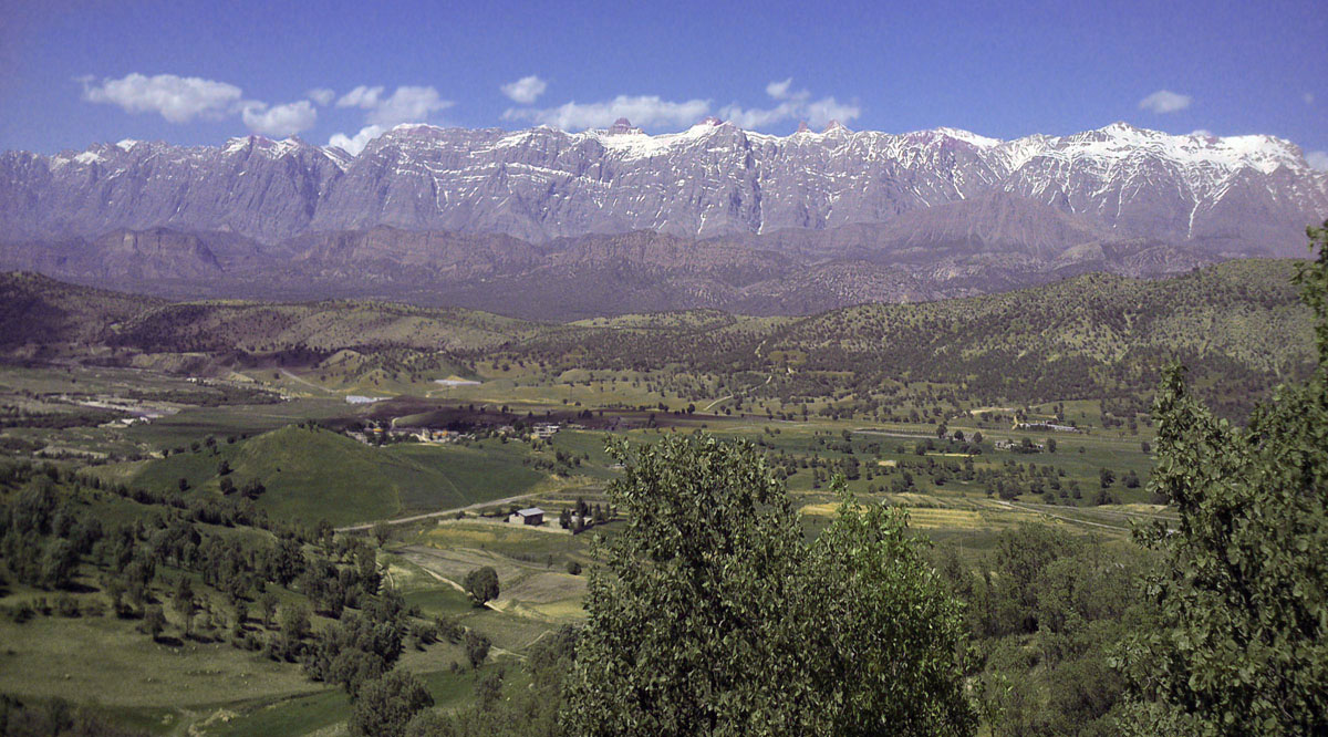
Dena (in Luri and fa, ) is the name for a sub-range within the Zagros Mountains, Iran. Mount Dena, with length and average width, is situated on the boundary of the Isfahan, Kohgiluyeh and Boyer-Ahmad and Chaharmahal and Bakhtiari Provinces of Iran. Mount Dena has more than 40 peaks higher than . With an elevation of 4,409 metres above sea level, Qash-Mastan is the highest peak in the Dena Range and in the Zagros Mountains in general. Another known peak in this range is Hose-Daal close to the city of Sisakht, to the north of Yasuj. Annual precipitation in Mount Dena ranges from and various rivers including a branch of the Karun rise in this range. Geologically, Mount Dena is located in the Sanandaj- Sirjan geologic and structural zone of Iran and is mainly made of Cretaceous limestone. On 18 February 2018, Iran Aseman Airlines Flight 3704 crashed into Mount Dena, killing all 65 people on board. Gallery Dena2.jpg, Dena3.jpg, Denaltgh6.jpg, Denaltgh4.jpg, ... [...More Info...] [...Related Items...] OR: [Wikipedia] [Google] [Baidu] |
Khar Turan National Park
Khar Turan National Park or Touran Wildlife Refuge is a National Park in Iran. It is situated in the Semnan province, southeast of Shahrud. With a size of , it is the second largest reserve in Iran. Khar Turan National Park also called the little Africa in Iran, is registered as the second biosphere reserve in the world by UNESCO (biosphere reserves are protected areas of ecosystems promoting solutions to reconcile the conservation of biodiversity with sustainable use), Turan National Park and Wildlife Refuge is one of the astonishing expanses to observe the mysteries of the wildlife accustomed to arid and semi-arid regions of Iran. Being the second-largest reserve in this country, this park embraces arid highlands, lowlands, mounts, sands, and endless salt pans. Fauna Khar Turan is home to one of the largest populations of the critically endangered Asiatic cheetah. There were about 12 – 15 of these cats in the area. Occasional reports of females with cubs indicate a breedi ... [...More Info...] [...Related Items...] OR: [Wikipedia] [Google] [Baidu] |
Lake Urmia
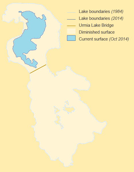
Lake Urmia; az, اۇرمۇ گؤلۆ, script=Arab, italic=no, Urmu gölü; ku, گۆلائوو رمیەیێ, Gola Ûrmiyeyê; hy, Ուրմիա լիճ, Urmia lich; arc, ܝܡܬܐ ܕܐܘܪܡܝܐ is an endorheic salt lake in Iran. The lake is located between the provinces of East Azerbaijan and West Azerbaijan in Iran, and west of the southern portion of the Caspian Sea. At its greatest extent, it was the largest lake in the Middle East and the sixth-largest saltwater lake on Earth, with a surface area of approximately , a length of , a width of , and a maximum depth of . By late 2017, the lake had shrunk to 10% of its former size (and 1/60 of water volume in 1998) due to persistent general drought in Iran, but also the damming of the local rivers that flow into it, and the pumping of groundwater from the surrounding area. This dry spell was broken in 2019 and the lake is now filling up once again, due to both increased rain and water diversion from the Zab River by th ... [...More Info...] [...Related Items...] OR: [Wikipedia] [Google] [Baidu] |
Kavir National Park
Kavir National Park is a protected ecological zone in northern Iran. It has an area of 4,000 square kilometers (1,500 mile²). The park is located 120 kilometers south of Tehran and 100 kilometers east of Qom, and it sits on the western end of one of Iran's two major deserts, the Dasht-e Kavir (Great Salt Desert). Siahkuh (Black Mountain), a large, semi-circular rock outcropping sits in roughly the park's center. The park encompasses landscapes of desert and steppes, and is sometimes known as "Little Africa" for its safari-like wildlife, including native goats (''Capra aegagrus''), sheep (''Ovis orientalis''),Mohammadian,H. Mammals of Iran. Shabpareh Publishing Institute. Tehran, Iran.2005.. striped hyenas, Indian wolves, gazelles, the rare Asiatic cheetahs, and the Persian leopards. Typically, the area receives around 150 millimeters (6 inches) of rain a year, most of which falls between November and May. The vegetation in the region is adapted to drought and salty soils. ... [...More Info...] [...Related Items...] OR: [Wikipedia] [Google] [Baidu] |
.jpg)


