|
Beit Herut
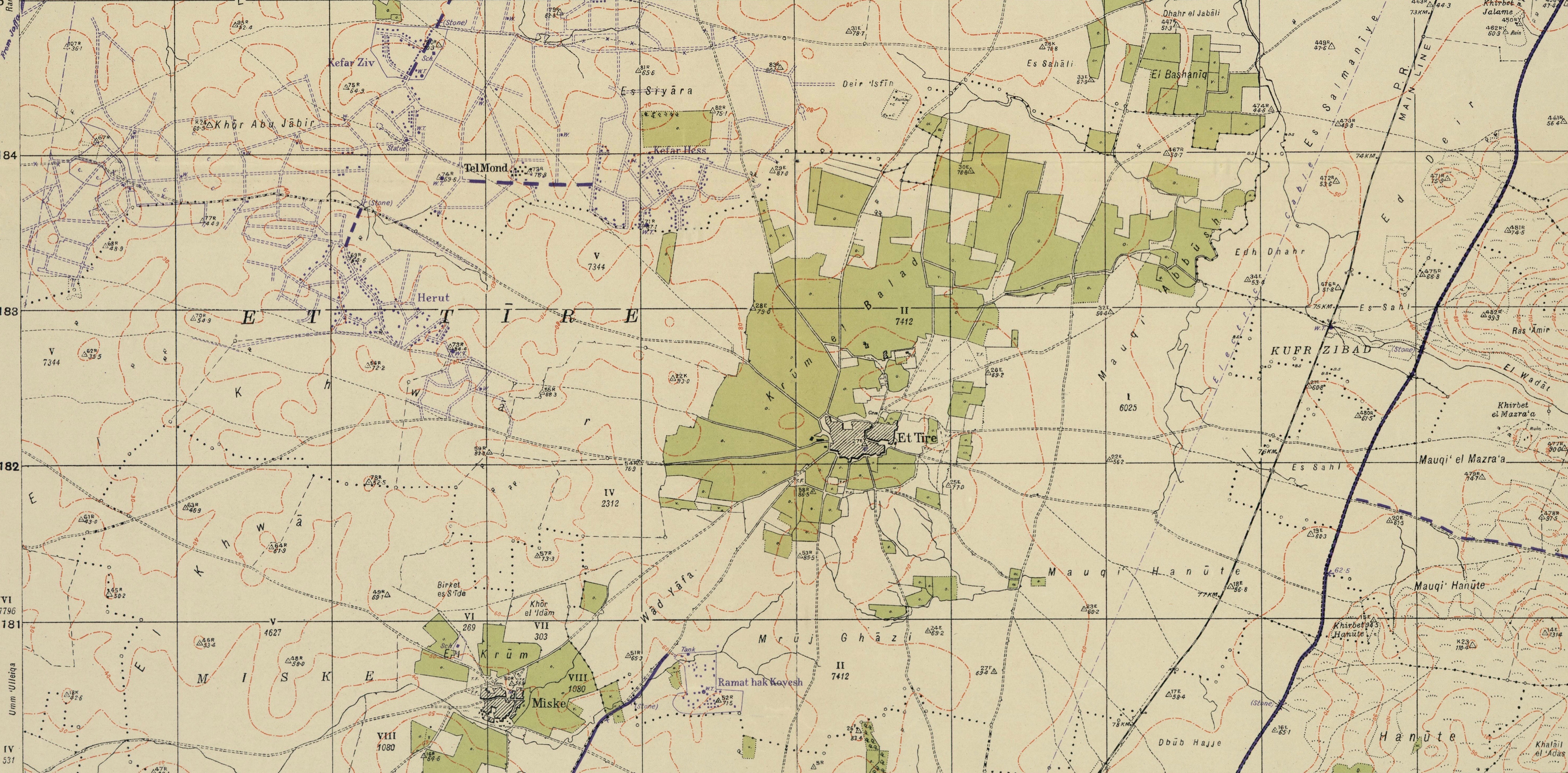
Beit Herut ( he, בֵּית חֵרוּת, ''lit.'' House of Freedom) is a moshav in central Israel. Located in the Sharon plain between Hadera and Netanya, it falls under the jurisdiction of Hefer Valley Regional Council. In it had a population of . History The moshav was founded in 1933 by immigrants from the United States, and was initially named Herut America Bet, as the moshav now known as Herut was named ''Herut America Alef'' at the time (there was also a ''Herut America Gimel'', which is today called Hadar Am). The name was taken from the organisation which helped the residents immigrate to Mandate Palestine Mandatory Palestine ( ar, فلسطين الانتدابية '; he, פָּלֶשְׂתִּינָה (א״י) ', where "E.Y." indicates ''’Eretz Yiśrā’ēl'', the Land of Israel) was a geopolitical entity established between 1920 and 1948 i .... References External links * {{Authority control American-Jewish culture in Israel Moshavim Populated places ... [...More Info...] [...Related Items...] OR: [Wikipedia] [Google] [Baidu] |
United States
The United States of America (U.S.A. or USA), commonly known as the United States (U.S. or US) or America, is a country primarily located in North America. It consists of 50 states, a federal district, five major unincorporated territories, nine Minor Outlying Islands, and 326 Indian reservations. The United States is also in free association with three Pacific Island sovereign states: the Federated States of Micronesia, the Marshall Islands, and the Republic of Palau. It is the world's third-largest country by both land and total area. It shares land borders with Canada to its north and with Mexico to its south and has maritime borders with the Bahamas, Cuba, Russia, and other nations. With a population of over 333 million, it is the most populous country in the Americas and the third most populous in the world. The national capital of the United States is Washington, D.C. and its most populous city and principal financial center is New York City. Paleo-Americ ... [...More Info...] [...Related Items...] OR: [Wikipedia] [Google] [Baidu] |
Hefer Valley Regional Council
The Hefer Valley Regional Council ( he, מועצה אזורית עמק חפר, ''Mo'atza Azorit Emek Hefer'') is a regional council in the Hefer Valley region of the Sharon plain in central Israel. It is named after an administrative district in this area in the time of King Solomon (). The council covers an area adjacent to Hadera in the north, to Netanya in the south, to the Mediterranean in the west and to Tulkarm and the Green Line in the east. As of December 2020, the jurisdiction area of the council has a population of about 42,600 people. The Regional Council offices are located near Kfar Monash, at the Ruppin junction, next to the Ruppin Academic Center. History The region of Emek Hefer covers an area known to its former Palestinian inhabitants as Wadi al-Hawarith Gabriel Piterberg,''The Returns of Zionism Myths, Politics and Scholarship in Israel,'' Verso Books 2008 p.ix;'I grew up in an affluent part of Israel which is strewn with labour Zionist cooperative set ... [...More Info...] [...Related Items...] OR: [Wikipedia] [Google] [Baidu] |
Moshav
A moshav ( he, מוֹשָׁב, plural ', lit. ''settlement, village'') is a type of Israeli town or settlement, in particular a type of cooperative agricultural community of individual farms pioneered by the Labour Zionists between 1904 and 1914, during what is known as the second wave of ''aliyah''. A resident or a member of a moshav can be called a "moshavnik" (). The moshavim are similar to kibbutzim with an emphasis on community labour. They were designed as part of the Zionist state-building programme following the green revolution Yishuv ("settlement") in the British Mandate of Palestine during the early 20th century, but in contrast to the collective farming kibbutzim, farms in a moshav tended to be individually owned but of fixed and equal size. Workers produced crops and other goods on their properties through individual or pooled labour with the profit and foodstuffs going to provide for themselves. Moshavim are governed by an elected council ( he, ועד, ''va'a ... [...More Info...] [...Related Items...] OR: [Wikipedia] [Google] [Baidu] |
Israel
Israel (; he, יִשְׂרָאֵל, ; ar, إِسْرَائِيل, ), officially the State of Israel ( he, מְדִינַת יִשְׂרָאֵל, label=none, translit=Medīnat Yīsrāʾēl; ), is a country in Western Asia. It is situated on the southeastern shore of the Mediterranean Sea and the northern shore of the Red Sea, and shares borders with Lebanon to the north, Syria to the northeast, Jordan to the east, and Egypt to the southwest. Israel also is bordered by the Palestinian territories of the West Bank and the Gaza Strip to the east and west, respectively. Tel Aviv is the economic and technological center of the country, while its seat of government is in its proclaimed capital of Jerusalem, although Israeli sovereignty over East Jerusalem is unrecognized internationally. The land held by present-day Israel witnessed some of the earliest human occupations outside Africa and was among the earliest known sites of agriculture. It was inhabited by the Canaanites ... [...More Info...] [...Related Items...] OR: [Wikipedia] [Google] [Baidu] |
Sharon Plain
The Sharon plain ( ''HaSharon Arabic: سهل شارون Sahel Sharon'') is the central section of the Israeli coastal plain. The plain lies between the Mediterranean Sea to the west and the Samarian Hills, to the east. It stretches from Nahal Taninim, a stream marking the southern end of Mount Carmel in the north, to the Yarkon River in the south, at the northern limit of Tel Aviv, over a total of about . The level of the Sharon plain is connected to the level of the Mediterranean Sea by the Sharon Escarpment. Parts of the Plain are included in the Central, Haifa and Tel Aviv Districts of Israel. History Early The Sharon valley is mentioned in an ancient Egyptian stele of Amenhotep II, and as the Sharon field containing both Jaffa and Dor on the Eshmunazar II sarcophagus. The Plain of Sharon is mentioned in the Bible ( 1 Chronicles 5:16, 27:29; Book of Isaiah 33:9, 35:2, 65:10), including the famous reference to the enigmatic "Rose of Sharon" ( Song of Songs 2:1). ... [...More Info...] [...Related Items...] OR: [Wikipedia] [Google] [Baidu] |
Hadera
Hadera ( he, חֲדֵרָה ) is a city located in the Haifa District of Israel, in the northern Sharon region, approximately 45 kilometers (28 miles) from the major cities of Tel Aviv and Haifa. The city is located along 7 km (5 mi) of the Israeli Mediterranean Coastal Plain. The city's population includes a high proportion of immigrants arriving since 1990, notably from Ethiopia and the former Soviet Union. In it had a population of . Hadera was established in 1891 as a farming colony by members of the Zionist group, Hovevei Zion, from Lithuania and Latvia. By 1948, it was a regional center with a population of 11,800. In 1952, Hadera was declared a city, with jurisdiction over an area of 53,000 dunams. History Ottoman era Hadera was founded on 24 January 1891, in the early days of modern Zionism by Jewish immigrants from Lithuania and Latvia on land purchased by Yehoshua Hankin, known as the Redeemer of the Valley. The land was purchased from a Chri ... [...More Info...] [...Related Items...] OR: [Wikipedia] [Google] [Baidu] |
Netanya
Netanya (also known as Natanya, he, נְתַנְיָה) is a city in the Northern Central District of Israel, and is the capital of the surrounding Sharon plain. It is north of Tel Aviv, and south of Haifa, between Poleg stream and Wingate Institute in the south and the Avihayil stream in the north. Netanya was named in honor of Nathan Straus, a prominent Jewish American merchant and philanthropist in the early 20th century who was the co-owner of Macy's department store. Its of beaches have made the city a popular tourist resort. In , it had a population of , making it the 7th-largest city in Israel by population. An additional 150,000 people live in the local and regional councils within of Netanya, which serves as a regional center for them. The city mayor is Miriam Feirberg. History Netanya was established near the ancient site of Poleg by the Bnei Binyamin association in Zikhron Ya'akov. It was named in honor of Nathan (Hebrew: ''Natan'') Straus (1848–1931), co- ... [...More Info...] [...Related Items...] OR: [Wikipedia] [Google] [Baidu] |
Aliyah
Aliyah (, ; he, עֲלִיָּה ''ʿălīyyā'', ) is the immigration of Jews from Jewish diaspora, the diaspora to, historically, the geographical Land of Israel, which is in the modern era chiefly represented by the Israel, State of Israel. Traditionally described as "the act of going up" (towards the Jerusalem in Judaism, Jewish holy city of Jerusalem), moving to the Land of Israel or "making aliyah" is one of the most basic tenets of Zionism. The opposite action—emigration by Jews from the Land of Israel—is referred to in the Hebrew language as ''yerida'' (). The Law of Return that was passed by the Knesset, Israeli parliament in 1950 gives all diaspora Jews, as well as their children and grandchildren, the right to relocate to Israel and acquire Israeli citizenship on the basis of connecting to their Jewish identity. For much of Jewish history, their history, most Jews have lived in the diaspora outside of the Land of Israel due to Jewish military history, various hi ... [...More Info...] [...Related Items...] OR: [Wikipedia] [Google] [Baidu] |
Herut, Israel
Herut ( he, חֵרוּת, ''lit.'' Freedom) is a moshav in central Israel. Located in the Sharon plain near Tel Mond, it falls under the jurisdiction of Lev HaSharon Regional Council. In it had a population of . History The village was founded in 1930 by the Herut society, an organization of immigrants who settled in Palestine during the Third and Fourth Aliyah. One of the early agricultural crops was peanuts. Landmarks buildings include a culture hall, Beit Ha'am, built in 1959.A tragic background to a festive atmosphere Haaretz
''Haaretz'' ( , originally ''Ḥadshot Haaretz'' – , ) is an Israeli newspaper. It was f ...
[...More Info...] [...Related Items...] OR: [Wikipedia] [Google] [Baidu] |
Hadar Am
Hadar Am ( he, הֲדַר עָם, ''lit.'' Nation Citrus) is a moshav in central Israel. Located in the Sharon plain near Netanya, it falls under the jurisdiction of Hefer Valley Regional Council. In it had a population of . History The moshav was founded in 1934 by aliyah, Jewish immigrants from Lithuania and North America, and was initially named Herut America Gimel (there were two other settlements named Herut America - ''Herut America Alef'' (now Herut, Israel, Herut) and ''Herut America Bet'' (now Beit Herut)) after the organisation which helped them immigrate. In 1943 it was renamed ''Hadar Am'' after citrus trees which surrounded the village. The founders were later joined by more immigrants from the Netherlands. Notable residents *Ofer Shechter References External linksOfficial website {{Authority control Moshavim Agricultural Union Populated places established in 1933 Populated places in Central District (Israel) 1933 establishments in Mandatory Palestine Lit ... [...More Info...] [...Related Items...] OR: [Wikipedia] [Google] [Baidu] |
Mandatory Palestine
Mandatory Palestine ( ar, فلسطين الانتدابية '; he, פָּלֶשְׂתִּינָה (א״י) ', where "E.Y." indicates ''’Eretz Yiśrā’ēl'', the Land of Israel) was a geopolitical entity established between 1920 and 1948 in the region of Palestine under the terms of the League of Nations Mandate for Palestine. During the First World War (1914–1918), an Arab uprising against Ottoman rule and the British Empire's Egyptian Expeditionary Force under General Edmund Allenby drove the Ottoman Turks out of the Levant during the Sinai and Palestine Campaign. The United Kingdom had agreed in the McMahon–Hussein Correspondence that it would honour Arab independence if the Arabs revolted against the Ottoman Turks, but the two sides had different interpretations of this agreement, and in the end, the United Kingdom and France divided the area under the Sykes–Picot Agreementan act of betrayal in the eyes of the Arabs. Further complicating the issue was t ... [...More Info...] [...Related Items...] OR: [Wikipedia] [Google] [Baidu] |


