|
Baspa Valley
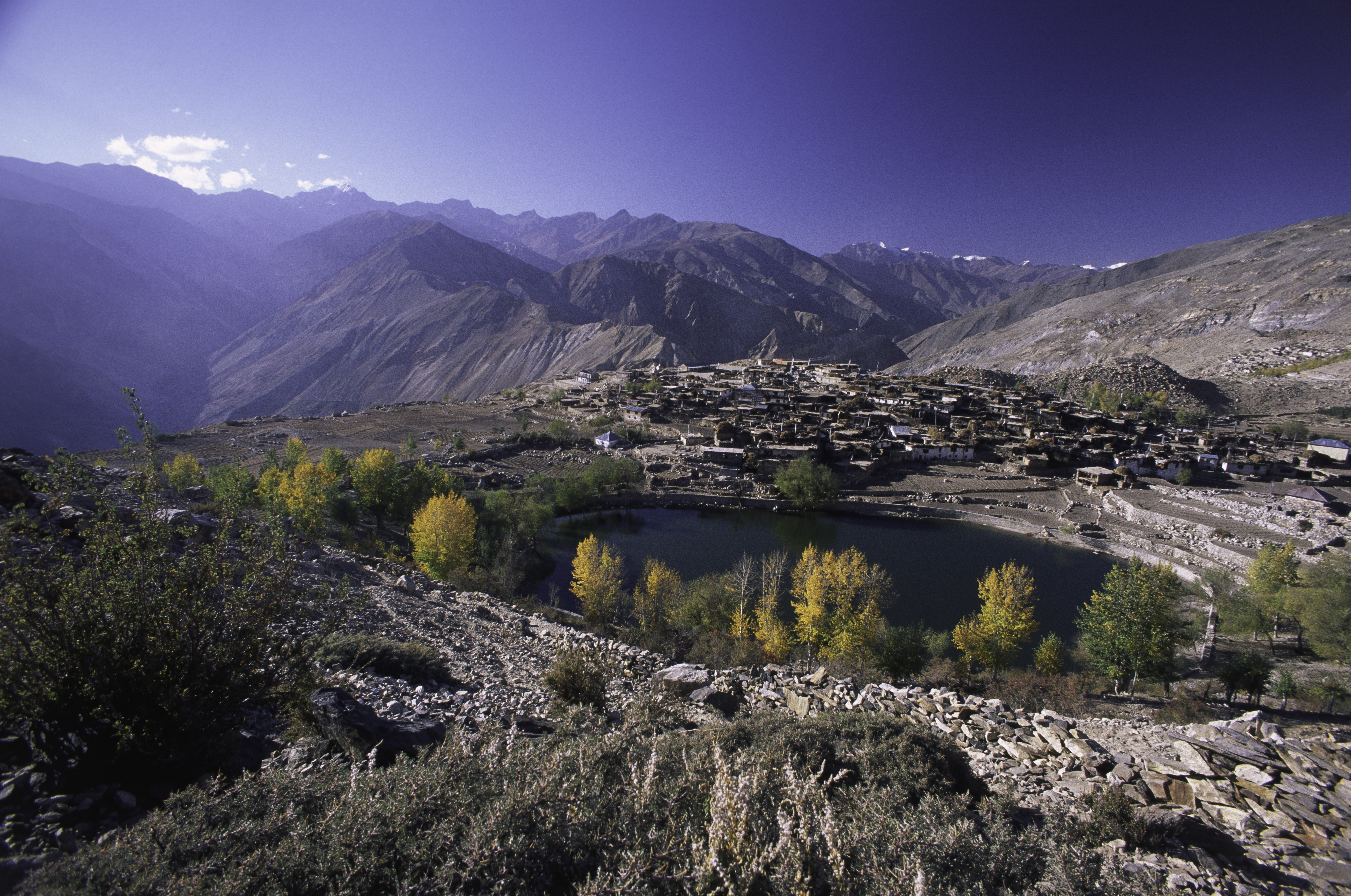
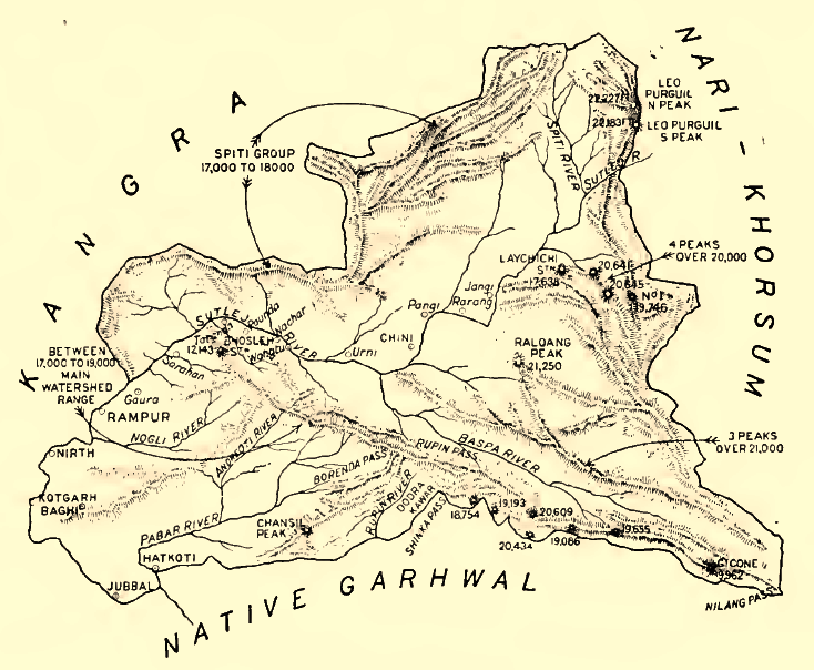
Baspa Valley is a river valley that is said to be named after the Baspa River. It lies in the Kinnaur District of Himachal Pradesh, India. Sangla, India, Sangla is a major town in the Baspa Valley, and the valley is also known as the Sangla Valley or Tukpa Valley. The villages inside the valley is Chitkul, Rakchham, Batseri, Sangla, Kamru, Himachal Pradesh, Kamru; the old capital of Bushahr state, Bushahr State and Chansu. History The Baspa river is a tributary to the Sutlej river, and one may approach the Baspa Valley by taking a diversion at Karcham, which is in the entrance of valley at NH-05. It opens into Satluj valley downstream of tshong-tong river.Baspa valley offers numerous trekking trails to neighbouring valleys like Jalandrigad valley via Lamkhaga pass, Har ki dun valley via Borasu pass, Sangla to Netwar via Rupin pass and Pabbar valley via Buran pass. Yamrang la pass & Gugairang La are the two passes situated on Indo-China border. Baspa River has a 300MW hyd ... [...More Info...] [...Related Items...] OR: [Wikipedia] [Google] [Baidu] |
Baspa River
Baspa River rises near the Indo-Chinese border and forms the Baspa Valley (also known as the Sangla Valley) - one of the most scenic in Himalayas. The Chung Sakhago Pass lies at the head of the valley. It is fed by the perennial glaciers and shares the catchment area with the Ganges. Baspa starts at the Baspa hills, joins Sutlej River from the left bank near Karcham. The upper and middle slopes of the valley along the river are covered with pine and oak forests. Pastures, meadows and fields cover the lower slopes. Some of the most picturesque villages in the Himalayas can be found here. Only the lower half of the 95 kilometers length of the valley is inhabited - all the way from Chitkul (3,475 m) to where the Baspa meets the Sutlej River at Karcham (1,830 m). Though gentle most of the way, it would be difficult to raft A raft is any flat structure for support or transportation over water. It is usually of basic design, characterized by the absence of a hull. Rafts are usu ... [...More Info...] [...Related Items...] OR: [Wikipedia] [Google] [Baidu] |
Kinnaur District
Kinnaur is one of the twelve administrative districts of the state of Himachal Pradesh in northern India. The district is divided into three administrative areas ( Kalpa, Nichar (Bhabanagar), and Pooh) and has six tehsils. The administrative headquarters of the district is at Reckong Peo. The mountain peak of Kinnaur Kailash is found in this district. As of 2011, it is the second least populous district of Himachal Pradesh (out of 12 districts), after Lahaul and Spiti. General Kinnaur is about from the state capital, Shimla, located in the northeast corner of Himachal Pradesh bordering Tibet to the east. It has three high mountain ranges, namely Zanskar and the Himalayas, that enclose the valleys of Baspa, Satluj, and Spiti, as well as their tributaries. The slopes are covered with thick wood, orchards, fields and hamlets. At the peak of Kinnaur Kailash mountain is a natural rock Shivling (Shiva lingam). The district was opened to outsiders in 1989. The old Hindustan ... [...More Info...] [...Related Items...] OR: [Wikipedia] [Google] [Baidu] |
Himachal Pradesh
Himachal Pradesh (; ; "Snow-laden Mountain Province") is a state in the northern part of India. Situated in the Western Himalayas, it is one of the thirteen mountain states and is characterized by an extreme landscape featuring several peaks and extensive river systems. Himachal Pradesh is the northernmost state of India and shares borders with the union territories of Jammu and Kashmir and Ladakh to the north, and the states of Punjab to the west, Haryana to the southwest, Uttarakhand to the southeast and a very narrow border with Uttar Pradesh to the south. The state also shares an international border to the east with the Tibet Autonomous Region in China. Himachal Pradesh is also known as , meaning 'Land of Gods' and which means 'Land of the Brave'. The predominantly mountainous region comprising the present-day Himachal Pradesh has been inhabited since pre-historic times, having witnessed multiple waves of human migrations from other areas. Through its history, the r ... [...More Info...] [...Related Items...] OR: [Wikipedia] [Google] [Baidu] |
India
India, officially the Republic of India ( Hindi: ), is a country in South Asia. It is the seventh-largest country by area, the second-most populous country, and the most populous democracy in the world. Bounded by the Indian Ocean on the south, the Arabian Sea on the southwest, and the Bay of Bengal on the southeast, it shares land borders with Pakistan to the west; China, Nepal, and Bhutan to the north; and Bangladesh and Myanmar to the east. In the Indian Ocean, India is in the vicinity of Sri Lanka and the Maldives; its Andaman and Nicobar Islands share a maritime border with Thailand, Myanmar, and Indonesia. Modern humans arrived on the Indian subcontinent from Africa no later than 55,000 years ago., "Y-Chromosome and Mt-DNA data support the colonization of South Asia by modern humans originating in Africa. ... Coalescence dates for most non-European populations average to between 73–55 ka.", "Modern human beings—''Homo sapiens''—originated in Africa. Th ... [...More Info...] [...Related Items...] OR: [Wikipedia] [Google] [Baidu] |
Sangla, India
Sangla is a town in the Baspa Valley, also referred to as the Sangla valley, in the Kinnaur District of Himachal Pradesh, India, close to the Tibet Tibet (; ''Böd''; ) is a region in East Asia, covering much of the Tibetan Plateau and spanning about . It is the traditional homeland of the Tibetan people. Also resident on the plateau are some other ethnic groups such as Monpa people, ...an border. Geography Sangla Valley or the Baspa Valley starts at Karcham and ends at Chitkul. Demographics The local people have a distinct culture and their own dialect, the Kinnauri language. Places of Interest Being located at center of the Baspa valley, Sangla is the locus of exploration and trekking trails. Kamru Fort Lake and Dam, Kupa Temples # Badrinath Temple, Kamru # Bering Nag Temple, Sangla # Batseri # Chitkul Mata Temple # Piri Nages Temple, Sapni Trek Routes # Rupin Valley Trek # Sangla Kande Trek # Charang Chitkul Trek Apart from these places, the tourist ... [...More Info...] [...Related Items...] OR: [Wikipedia] [Google] [Baidu] |
Chitkul
Chhitkul is a village in Kinnaur district of Himachal Pradesh. During winters, the place mostly remains covered with the snow and the inhabitants move to lower regions of Himachal. According to a recent study by Centre of Atmospheric Sciences at IIT Delhi, Chitkul has the cleanest air in India. Geography Chitkul, a village located on right bank of Baspa River, is the last village of the Baspa Valley and the last village on the old Hindustan-Tibet trade route. It is also the last point in India one can travel to without a permit. Visitor's attractions Of particular interest at Chitkul are its houses with either slate or wooden plank roofs, a Buddhist temple and a small tower. However, there has been an increased use of tin-roofs, especially the high school and the army/ITBP barracks. The Kagyupa temple has a highly valued old image of the Shakyamuni Buddha, a Wheel of Life mandala and four Directional Kings on either side of the door. Chitkul is practically the last point of ... [...More Info...] [...Related Items...] OR: [Wikipedia] [Google] [Baidu] |
Kamru, Himachal Pradesh
Kamru is a village located in the Sangla Valley of Kinnaur district, Himachal Pradesh, India. It sits c. 2,900 m above sea level and is about 2 km from the tourist town of Sangla, on the foot of Kinner-Kailash (House of Lord Shiva). History The village is an ancient capital of the Bashahr principate. It is especially known for the tower-like fort at its highest point, which was made by Lord Badrinath Ji thousands of year ago. Inside the fort there are about 33 types of gods and goddess. There is also a shrine to Kamakhya Devi inside the fort campus, which was brought there many years ago from Assam Assam (; ) is a state in northeastern India, south of the eastern Himalayas along the Brahmaputra and Barak River valleys. Assam covers an area of . The state is bordered by Bhutan and Arunachal Pradesh to the north; Nagaland and Manipur .... Kamru was capital of the Bushahr principality. It is especially known for the tower-like fort at its highest point, which ... [...More Info...] [...Related Items...] OR: [Wikipedia] [Google] [Baidu] |
Bushahr State
Bushahr, also spelt as 'Bashahr' and 'Bussahir' or 'Bushair' was a Rajput princely state in India during the British Raj. It was located in the hilly western Himalaya promontory bordering Tibet in the northern part of colonial Punjab region. The territory of this former state is now part of Kinnaur and Shimla districts of the present Himachal Pradesh state. The erstwhile Bushahr state was traversed by the Sutlej river. It was bordered on the west by the Kulu, Lahaul and Spiti states and by Tehri Garhwal on the east. It had an area of . History The erstwhile Bushahr state was occupied by a Gorkha king from central Nepal from 1803 to 1815. Ranjit Singh, the ruler of the Sikh state in the Punjab, intervened in 1809 and drove the Nepalese army east of the Satluj river. A rivalry between Nepal and the British East India Company over the annexation of minor states bordering Nepal eventually led to the Anglo-Nepalese War (1815–16) or the Gurkha War. Both parties eventually sig ... [...More Info...] [...Related Items...] OR: [Wikipedia] [Google] [Baidu] |
Sutlej
The Sutlej or Satluj River () is the longest of the five rivers that flow through the historic crossroads region of Punjab in northern India and Pakistan. The Sutlej River is also known as ''Satadru''. It is the easternmost tributary of the Indus River. The Bhakra Dam is built around the river Sutlej to provide irrigation and other facilities to the states of Punjab, Rajasthan and Haryana. The waters of the Sutlej are allocated to India under the Indus Waters Treaty between India and Pakistan, and are mostly diverted to irrigation canals in India like the Sirhind Canal, Bhakra Main Line and the Rajasthan canal. The mean annual flow is 14 million acre feet (MAF) upstream of Ropar barrage, downstream of the Bhakra dam. It has several major hydroelectric points, including the 1,325 MW Bhakra Dam, the 1,000 MW Karcham Wangtoo Hydroelectric Plant, and the 1,500 MW Nathpa Jhakri Dam. The drainage basin in India includes the states and union territories of Hima ... [...More Info...] [...Related Items...] OR: [Wikipedia] [Google] [Baidu] |
Geography Of Kinnaur District
Geography (from Greek: , ''geographia''. Combination of Greek words ‘Geo’ (The Earth) and ‘Graphien’ (to describe), literally "earth description") is a field of science devoted to the study of the lands, features, inhabitants, and phenomena of Earth. The first recorded use of the word γεωγραφία was as a title of a book by Greek scholar Eratosthenes (276–194 BC). Geography is an all-encompassing discipline that seeks an understanding of Earth and its human and natural complexities—not merely where objects are, but also how they have changed and come to be. While geography is specific to Earth, many concepts can be applied more broadly to other celestial bodies in the field of planetary science. One such concept, the first law of geography, proposed by Waldo Tobler, is "everything is related to everything else, but near things are more related than distant things." Geography has been called "the world discipline" and "the bridge between the human and t ... [...More Info...] [...Related Items...] OR: [Wikipedia] [Google] [Baidu] |


