|
Afon Alaw
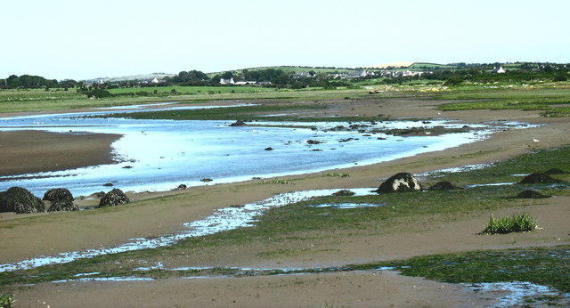
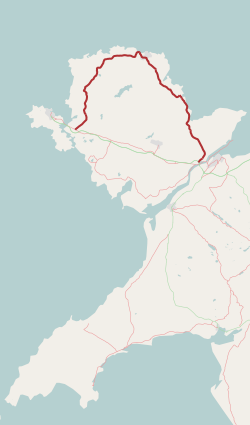
The Afon Alaw ( en, River Alaw) is a river on Anglesey (Welsh: Ynys Môn) in Wales which rises near Llanerch-y-medd and flows northwards into the reservoir of Llyn Alaw. Below the dam it then flows southwestwards to the island's west coast near Llanfachraeth. Its lower reaches, west of the A5025 road The A5025 is an 'A' road that runs from Llanfairpwllgwyngyll to Valley in Anglesey, Wales. A major road around the north coast of the isle, it runs up the east, north and finally north-west side of the island via several places including Benll ..., are tidal.Ordnance Survey Landranger map sheet 114 ''Anglesey/Môn'' References Rivers of Anglesey {{Wales-river-stub ... [...More Info...] [...Related Items...] OR: [Wikipedia] [Google] [Baidu] |
Afon Alaw 519500
This is a list of rivers of Wales, organised geographically. It is taken anti-clockwise from the Dee Estuary to the M48 Bridge that separates the estuary of the River Wye from the River Severn. Tributaries are listed down the page in an upstream direction, starting with those closest to the sea. The main stem (or principal) river of a catchment is given, left-bank tributaries are indicated by (L), and right-bank tributaries by (R). Note that, in general usage, the 'left (or right) bank of a river' refers to the left (or right) hand bank as seen when looking downstream. Where a named river is formed by the confluence of two differently named rivers, these are labelled as (Ls) and (Rs) for the left and right forks. A prime example is the formation of the River Taff from the Taf Fawr and the Taf Fechan at Cefn Coed-y-cymmer. The list includes more or less every watercourse named on Ordnance Survey mapping and thus many of the main rivers of Wales (as defined by Natural Resources W ... [...More Info...] [...Related Items...] OR: [Wikipedia] [Google] [Baidu] |
Anglesey
Anglesey (; cy, (Ynys) Môn ) is an island off the north-west coast of Wales. It forms a principal area known as the Isle of Anglesey, that includes Holy Island across the narrow Cymyran Strait and some islets and skerries. Anglesey island, at , is the largest in Wales, the seventh largest in Britain, largest in the Irish Sea and second most populous there after the Isle of Man. Isle of Anglesey County Council administers , with a 2011 census population of 69,751, including 13,659 on Holy Island. The Menai Strait to the mainland is spanned by the Menai Suspension Bridge, designed by Thomas Telford in 1826, and the Britannia Bridge, built in 1850 and replaced in 1980. The largest town is Holyhead on Holy Island, whose ferry service with Ireland handles over two million passengers a year. The next largest is Llangefni, the county council seat. From 1974 to 1996 Anglesey was part of Gwynedd. Most full-time residents are habitual Welsh speakers. The Welsh name Ynys M ... [...More Info...] [...Related Items...] OR: [Wikipedia] [Google] [Baidu] |
Welsh Language
Welsh ( or ) is a Celtic language family, Celtic language of the Brittonic languages, Brittonic subgroup that is native to the Welsh people. Welsh is spoken natively in Wales, by some in England, and in Y Wladfa (the Welsh colony in Chubut Province, Argentina). Historically, it has also been known in English as "British", "Cambrian", "Cambric" and "Cymric". The Welsh Language (Wales) Measure 2011 gave the Welsh language official status in Wales. Both the Welsh and English languages are ''de jure'' official languages of the Welsh Parliament, the Senedd. According to the 2021 United Kingdom census, 2021 census, the Welsh-speaking population of Wales aged three or older was 17.8% (538,300 people) and nearly three quarters of the population in Wales said they had no Welsh language skills. Other estimates suggest that 29.7% (899,500) of people aged three or older in Wales could speak Welsh in June 2022. Almost half of all Welsh speakers consider themselves fluent Welsh speakers ... [...More Info...] [...Related Items...] OR: [Wikipedia] [Google] [Baidu] |
Wales
Wales ( cy, Cymru ) is a Countries of the United Kingdom, country that is part of the United Kingdom. It is bordered by England to the Wales–England border, east, the Irish Sea to the north and west, the Celtic Sea to the south west and the Bristol Channel to the south. It had a population in 2021 of 3,107,500 and has a total area of . Wales has over of coastline and is largely mountainous with its higher peaks in the north and central areas, including Snowdon (), its highest summit. The country lies within the Temperateness, north temperate zone and has a changeable, maritime climate. The capital and largest city is Cardiff. Welsh national identity emerged among the Celtic Britons after the Roman withdrawal from Britain in the 5th century, and Wales was formed as a Kingdom of Wales, kingdom under Gruffydd ap Llywelyn in 1055. Wales is regarded as one of the Celtic nations. The Conquest of Wales by Edward I, conquest of Wales by Edward I of England was completed by 1283, th ... [...More Info...] [...Related Items...] OR: [Wikipedia] [Google] [Baidu] |
Llanerch-y-medd
Llannerch-y-medd, is a small village, community and post town on the Isle of Anglesey in Wales. The Royal Mail postcode is LL71, and it has a population of 1,360, of whom more than 70% is Welsh speaking. The village is situated near the centre of Anglesey close to the large water supply reservoir, Llyn Alaw, and is believed to have an ancient foundation. ''Llannerch'' means "a woodland clearing". The word ''medd'' in the name is Welsh for mead, which is made from honey, and the name may be related to the production of honey for mead. The disused Anglesey Central Railway runs through the village. Its station, opened in 1866, was closed in 1964 as part of the Beeching Axe, and its goods yard is now a car park. There is now a cafe and tea rooms housed in a modern extension of the old buildings. Just to the northeast of the village is the hill called Pen y Foel which is 123m above sea level; between 1951 and 1956 this was the site of a VHF Fixer station, part of the RAF Western ... [...More Info...] [...Related Items...] OR: [Wikipedia] [Google] [Baidu] |
Llyn Alaw
Llyn Alaw (meaning: ''Lily Lake'') is a man-made reservoir on Anglesey, North Wales managed by Dŵr Cymru Welsh Water. It is a shallow lake and was built in 1966. It is a Site of Special Scientific Interest and a destination for over-wintering birds. History It is used to supply drinking water to the northern half of the island and does so at a rate of 35 million litres a day. Filling began in November 1965, flooding the existing marsh of Cors y Bol, and was completed in January 1966. It was officially opened on 21 October 1966. Due to the area being marshland no houses or farms, let alone hamlets or villages had to be abandoned to create it. The catchment is largely agricultural, and few notable rivers feed into the lake. The storage capacity is mostly generated through trapping winter rainfall and drawing down the level in the summer months. The reservoir itself is 4.3 kilometres long with a surface area of 3.6 km2 making it the largest body of water on the island, but ... [...More Info...] [...Related Items...] OR: [Wikipedia] [Google] [Baidu] |
Llanfachraeth
Llanfachraeth is a village and community in Anglesey, Wales. It is located near the west coast of the island, at the head of the Alaw estuary, east of Holyhead, south west of Amlwch and north west of Llangefni. The A5025 road runs through the village. A bus service operates along this road daily, except for Sundays, running between Cemaes, Llanfaethlu, Llanfachraeth and Holyhead. The Wales Coast Path is forced inland here to cross the Afon Alaw. The village has a pub and accommodation is provided by the Holland Hotel. At the 2001 census the community had a population of 566, increasing slightly at the 2011 census to 589. In the extreme north of the community, on the border with Llanfaethlu, stands Gronant, a Grade II* listed sub-medieval house dating from around 1540. A second house was built around 1618. In the 19th century the two houses were joined and a bell turret, used to call servants for meals, was added. The former servants' loft contains fragments of an o ... [...More Info...] [...Related Items...] OR: [Wikipedia] [Google] [Baidu] |
A5025 Road
The A5025 is an 'A' road that runs from Llanfairpwllgwyngyll to Valley in Anglesey, Wales. A major road around the north coast of the isle, it runs up the east, north and finally north-west side of the island via several places including Benllech and Amlwch. In all the road is long. Description The A5025 begins at the A55 road, near Sant Tysilio Nursing Home on the northeastern outskirts of Llanfairpwllgwyngyll. It initially heads northeast but soon teeters northwest as its passes Pentraeth Motors. It continues northwest, passing through the town of Pentraeth itself, where it crosses the B5109 road, and then heads north through the coastal town of Benllech. The stretch of road in Benllech is known as Bangor Road. It heads northwest again, crossing the B5110 road, before briefly turning southwest at the junction with the A5108 road to the northeast of Llanallgo. After passing through Llanallgo it heads north-northwest through Brynrefail, Llaneuddog, and Penysarn. Northwest of ... [...More Info...] [...Related Items...] OR: [Wikipedia] [Google] [Baidu] |


