|
Ab'aro
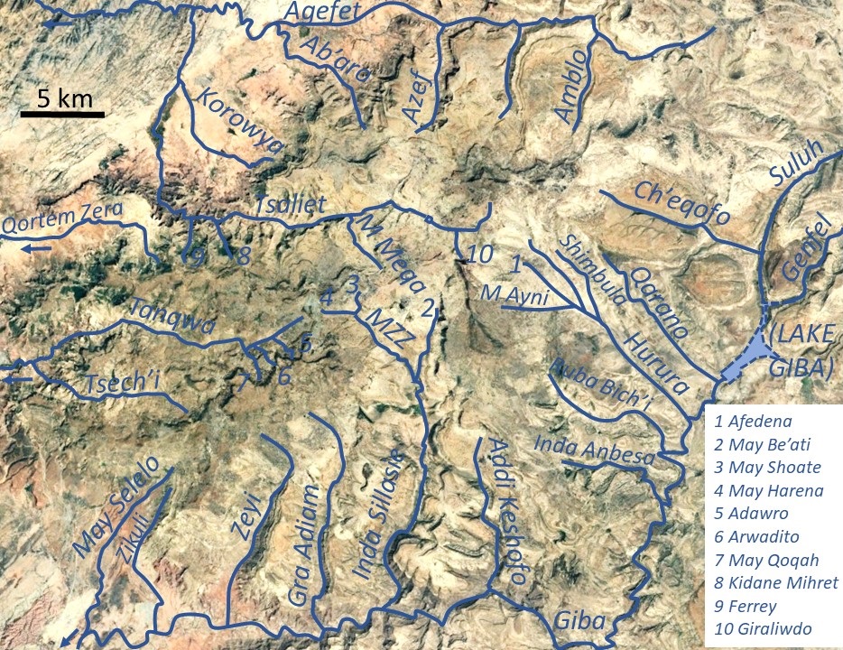
Ab’aro is a river of the Nile basin. Rising in the mountains of Dogu’a Tembien in northern Ethiopia, it flows northwestward to empty finally in Weri’i and Tekezé River. Characteristics Ab’aro is a confined ephemeral river in its upper part, whereas it widely meanders in the lower plains, with an average slope gradient of 60 metres per kilometre. Towards the footslope the river has cut a deep gorge (a cluse). Flash floods Runoff mostly occurs in the form of high runoff discharge events that occur in a very short period (called flash floods). These are related to the steep topography, often little vegetation cover and intense convective rainfall. The peaks of such flash floods have often a 50 to 100 times larger discharge than the preceding baseflow. In contrast to neighbouring rivers such as May Meqa, May Shoate or Giraliwdo, the magnitude of floods in Ab’aro has not been decreased due to interventions in the catchment. Physical conservation structures such as ... [...More Info...] [...Related Items...] OR: [Wikipedia] [Google] [Baidu] |
Haddinnet
Haddinnet, also transliterated as Hadnet, is a ''tabia'' or municipality in the Dogu'a Tembien district of the Tigray Region of Ethiopia. The ''tabia'' centre is in Addi Idaga village, located approximately 6.5 km to the northeast of the ''woreda'' town Hagere Selam. Geography The ''tabia'' is located on the southern and northern slopes of the Tsili ridge in the northern part of Dogu'a Tembien. The highest peak is Dabba Selama (2630 m a.s.l.) (not to be confounded with the homonymous monastery) and the lowest place along Agefet River (1720 m a.s.l.). Geology From the higher to the lower locations, the following geological formations are present: * Phonolite plugs * Upper basalt * Interbedded lacustrine deposits * Lower basalt * Amba Aradam Formation * Agula Shale * Antalo Limestone * Adigrat Sandstone * Edaga Arbi Glacials * Quaternary alluvium and freshwater tufa Climate The rainfall pattern shows a very high seasonality with 70 to 80% of the a ... [...More Info...] [...Related Items...] OR: [Wikipedia] [Google] [Baidu] |
Degua Tembien
Dogu'a Tembien (, "Upper Tembien", sometimes transliterated as Degua Tembien) is a woreda in Tigray Region, Ethiopia. It is named in part after the former province of Tembien. Nowadays, the mountainous district is part of the Southeastern Tigray Zone. The administrative centre of this woreda is Hagere Selam. History Dogu’a Tembien holds numerous prehistoric sites, which have been dated to the Middle Stone Age in Ayninbirkekin, or Pastoral Neolithic in Aregen and Menachek. Geography Topography and landscapes Major mountains :* Tsatsen, 2815 metres, a wide mesa between Hagere Selam and Inda Maryam Qorar () :* Ekli Imba, 2799 metres, summit of the Arebay massif in Arebay ''tabia'' or district () :* Imba Zuw’ala, 2710 metres, near Hagere Selam () :* Aregen, 2660 metres, in Aregen ''tabia'' () :* Dabba Selama, 2630 metres, in Haddinnet ''tabia'' () (not to be confused with the homonymous monastery) :* Imba Dogu’a, 2610 metres, in Mizane Birhan ''tabia'' () :* Imba Ra� ... [...More Info...] [...Related Items...] OR: [Wikipedia] [Google] [Baidu] |
Agefet
Agefet is a river of the Nile basin. Rising in the mountains of Gheralta in northern Ethiopia, it flows westward to empty finally in Weri’i and Tekezé River. Characteristics It is a confined ephemeral river, locally meandering in its narrow alluvial plain, with an average slope gradient of 13 metres per kilometre. At the end of its course, it occupies a sandy pediment. Flash floods and flood buffering Runoff mostly happens in the form of high runoff discharge events that occur in a very short period (called flash floods). These are related to the steep topography, often little vegetation cover and intense convective rainfall. The peaks of such flash floods have often a 50 to 100 times larger discharge than the preceding baseflow. The magnitude of floods in this river has however been decreased due to interventions in the catchment. Physical conservation structures such as stone bunds and check dams intercept runoff. On many steep slopes, exclosures have been establishe ... [...More Info...] [...Related Items...] OR: [Wikipedia] [Google] [Baidu] |
Wari River
Wari River is a river of northern Ethiopia and a tributary of the Tekezé River. It rises in the Gar'alta and flows to the southwest into the Tekezé at . Tributaries of the Wari include the Assam, Chemit, Meseuma, Tsedia, Agefet and Tsaliet rivers. The general drainage is westward, to the Tekezze River. Main tributaries in Dogu’a Tembien district are, from upstream to downstream * Agefet River ** Amblo River, in ''tabia'' Addi Walka ** Azef River, at the border of ''tabias'' Addi Walka and Haddinnet ** Ab'aro River, in ''tabia'' Haddinnet and ''woreda'' Kola Tembien * May Leiba, in ''tabia'' Ayninbirkekin, which becomes Tinsehe R. in Selam and Mahbere Sillasie, and Tsaliet River, downstream from the Dabba Selama monastery ** Khunale River, in ''tabia'' Selam ** Harehuwa River, in ''tabia'' Mahbere Sillasie ** Kidan Mihret River, in ''tabia'' Mahbere Sillasie ** Ferrey River, at the border of ''tabias'' Mahbere Sillasie and Degol Woyane See also * List of rivers of Ethiopi ... [...More Info...] [...Related Items...] OR: [Wikipedia] [Google] [Baidu] |
Cluse
William Sampson Cluse (20 December 1875 – 8 September 1955) was a British Labour Party politician. Born in Islington, he was orphaned at the age of five, by the time he was eleven Cluse was working part-time. At the age of fifteen he was apprenticed to the printing trade. In 1900 he entered politics, joining the Social Democratic Federation. During the First World War he served in the Royal Army Medical Corps. Following the war he entered local government when he was elected to Islington Borough Council as a Labour Party councillor representing Tollington Ward in 1919. At the 1922 municipal elections he was elected to the council again, this time as a representative of St Peter's Ward. At the 1923 general election he was elected Member of Parliament for Islington South. Re-elected twice, he lost his seat at the 1931 general election. He regained the seat in 1935, retiring from parliament at the 1950 general election. He held a minor post in the war-time coalition g ... [...More Info...] [...Related Items...] OR: [Wikipedia] [Google] [Baidu] |
Alaji Basalts
The Alaji (upper) Basalts are the youngest series of the Ethiopian flood basalts. The most recent flows are only 15 million years old. Name and definition The name was coined by geologist William Thomas Blanford, who accompanied the British Expedition to Abyssinia in 1868, after the Imba Alaje mountain. So far the nomenclature has not been proposed for recognition to the International Commission on Stratigraphy. Stratigraphic context Uppermost Tertiary flood basalts in Ethiopia. Locally they are covered by Pliocene shield volcanoes, such as the Simien Mountains, or Mount Guna. These flows have been deposited on the lower Ashangi Basalts and locally on intra-volcanic sedimentary rock. Environment Like all volcanic rocks, the Alaji Basalts originate from initial melting of the Earth's mantle. After extrusion, the magmatic structures form at the surface. Common volcanic structures such as lava tubes or ropy lavas are absent in the Alaji Basalts, but (columnar joints) are omnipres ... [...More Info...] [...Related Items...] OR: [Wikipedia] [Google] [Baidu] |
Baseflow
Baseflow (also called drought flow, groundwater recession flow, low flow, low-water flow, low-water discharge and sustained or fair-weather runoff) is the portion of the streamflow that is sustained between precipitation events, fed to streams by delayed pathways. It should not be confused with groundwater flow. Fair weather flow is also called base flow. Importance Baseflow is important for sustaining human centers of population and ecosystems. This is especially true for watersheds that do not rely on snowmelt. Different ecological processes will occur at different parts of the hydrograph. During the baseflow ascending limb, there is frequently more stream area and habitat available for water-dependent species, spawning salmon for example. During the recession limb which in California is from May to October, there is increasingly less stream area, indigenous species are more adept at surviving in low flow conditions than introduced species. Geology Baseflow is derived from ... [...More Info...] [...Related Items...] OR: [Wikipedia] [Google] [Baidu] |
Tigray Region
The Tigray Region, officially the Tigray National Regional State, is the northernmost regional state in Ethiopia. The Tigray Region is the homeland of the Tigrayan, Irob, and Kunama people. Its capital and largest city is Mekelle. Tigray is the fifth-largest by area, the fifth-most populous, and the fifth-most densely populated of the 11 regional states. Tigray's official language is Tigrinya, similar to that spoken in Eritrea just to the North. The estimated population as of 2019 is 5,443,000. The majority of the population (c. 80%) are farmers, contributing 46% to the regional gross domestic product (2009). The highlands have the highest population density, especially in eastern and central Tigray. The much less densely populated lowlands comprise 48% of Tigray's area. Like many parts of Africa, Tigray is far from a religious monolith. Despite the historical identification of Ethiopia with Orthodox Christianity, the presence of Islam in Ethiopia is as old as the religion ... [...More Info...] [...Related Items...] OR: [Wikipedia] [Google] [Baidu] |
Phonolite Series In North Ethiopia
The phonolite or clinkstone of northern Ethiopia is a shallow-seated igneous rock. The phonolites intruded and punctured the Mesozoic sedimentary rocks and the Tertiary flood basalts some 19 to 11 million years ago. Stratigraphic context The formation occurs as plugs that have punctured the Tertiary flood basalts of the Ethiopian plateau, and form the highest peaks in their surrounding. Lithology These phonolites are composed of alkali pyroxenes and nephelines; there are also elongated plagioclase crystals. Pyroxenes have a skeletal texture, whereas nepheline crystals are hexagonal to rectangular. The phonolites of pink to light grey colour. The outcrops hold massive (up to 25 metres long), moderately weathered blocks, generally of elongated shape; in some locations it also forms spherical outcrops. Geographical extent These silica-poor rocks belong to the Adwa-Aksum trachy-phonolite volcanic field. They are also exposed in Addi Amyuq, some 3 kilometres north of Hagere Selam, ... [...More Info...] [...Related Items...] OR: [Wikipedia] [Google] [Baidu] |
Ashangi Basalts
The Ashangi Basalts are the earliest Tertiary volcanic rocks in north Ethiopia, hence they are in the lowest position. These dark porphyritic basalts are separated from the Mesozoic formations below it by basal Conglomerate (geology), conglomerates. The basalts hold phenocrysts that developed before the magma reached the earth surface. These basalts are weathered, partially eroded and have a sub-horizontal stratification, particularly at the lower part. This series was created during the first period of the flood basalt eruptions in north Ethiopia, in the Oligocene. Name and definition The name was coined by geologist William Thomas Blanford, who accompanied the British Expedition to Abyssinia in 1868,{{cite book , last1=Blanford , first1=W.T. , title=Observations on the geology and zoology of Abyssinia, made during the progress of the British expedition to that country in 1867-68 , url=https://archive.org/details/cu31924024736666 , date=1870 , publisher=Macmillan and Co. , location ... [...More Info...] [...Related Items...] OR: [Wikipedia] [Google] [Baidu] |
Intra-volcanic Sedimentary Rock In North Ethiopia
Between 29 and 27 million years ago, the extrusion of Ethiopia’s flood basalts was interrupted and deposition of continental sediments occurred. Inter-trappean beds outcrop in many places of the Ethiopian highlands. They consist of fluvio-lacustrine deposits, that are generally a few tens of metres thick. Often, these interbedded fluvio-lacustrine deposits are very visible because their bright colours strongly contrast with the basalt environment. Name and definition The formation, also called ''silicified limestone'' and ''interbedded lacustrine deposits'' was first extensively characterised in the 1930s by Merla and Minucci. Stratigraphic context The formation is generally at the interface between the lower Ashangi Basalts, and the upper Alaji Basalts. Environment The sediments were deposited in shallow lakes and marshes in large topographic depressions. The dense vegetation hosted mammals and birds, which found their food between the reeds of the lake shores. The decompos ... [...More Info...] [...Related Items...] OR: [Wikipedia] [Google] [Baidu] |


