|
Augst
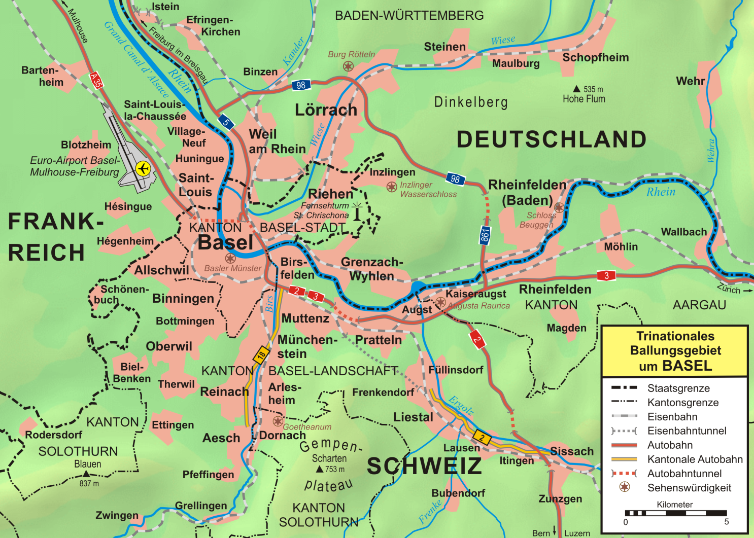
Augst (Swiss German: ''Augscht'') is a municipality in the district of Liestal in the canton of Basel-Country in Switzerland. It was known as Augusta Raurica in Roman times. History Augst is first mentioned in 615 as ''Augustodunensem praesulem''. In 752 it was mentioned as ''Augusta'' and in 1288 as ''Augst''. Geography Augst has an area, , of . Of this area, or 34.8% is used for agricultural purposes, while or 6.7% is forested. Of the rest of the land, or 40.2% is settled (buildings or roads), or 17.1% is either rivers or lakes.Swiss Federal Statistical Office-Land Use Statistics 2009 data accessed 25 March 2010 Of the built up area, industrial buildings made up 6.1% of the total area while housing and buildings made up 11.0% and transpo ... [...More Info...] [...Related Items...] OR: [Wikipedia] [Google] [Baidu] |
Augusta Raurica
Augusta Raurica is a Roman Empire, Roman archaeological site and an open-air museum in Switzerland located on the south bank of the Rhine, Rhine river about 20 km east of Basel near the villages of Augst and Kaiseraugst. It is the site of the oldest known Roman colony on the Rhine. Founding Augusta Raurica, or ''Colonia Augusta Rauracorum'', was Colonia (Roman), founded by Lucius Munatius Plancus around 44 BC in the vicinity of a local Gallic tribe, the Rauraci, relatives of the Helvetii. No archaeological evidence from this period has yet been found, leading to the conclusion that, either the settlement of the colony was disturbed by the Mark Antony#Enemy of the state and triumvirate, civil war following the death of Julius Caesar, or that Plancus' colony was actually in the area of modern Basel, not Augst. Successful colonization of the site had to wait for Augustus' Conquest of the Alps, conquest of the central Alps around 15 BC. The oldest find to date at A ... [...More Info...] [...Related Items...] OR: [Wikipedia] [Google] [Baidu] |
Kaiseraugst
Kaiseraugst ( Swiss German: ''Chäiseraugscht'') is a municipality within the district of Rheinfelden in the canton of Aargau in Switzerland. It is named after the Ancient Roman city of Augusta Raurica whose ruins are situated nearby. The prefix ''Kaiser-'' ("imperial") refers to the fact that from medieval times this town formed part of the Habsburg territory of Further Austria, as opposed to neighbouring village of Augst, part of the then Canton of Basel in the Old Swiss Confederacy. History About AD 300, following the loss of the Limes Germanicus and the right bank of the Rhine, the Roman army built a fort near the city of Augusta Raurica. The fort, which was named ''Castrum Rauracense'' was intended to serve as the headquarters of the '' legio I Martia'' and to protect a ford over the Rhine. During the 4th century, the fort grew in importance because it commanded a bridge that lay along the road from Gaul to the Danube, and sometime around 337 and 341 AD, an amphithe ... [...More Info...] [...Related Items...] OR: [Wikipedia] [Google] [Baidu] |
Giebenach
Giebenach is a municipality in the district of Liestal in the canton of Basel-Country in Switzerland. History Giebenach is first mentioned in 1246 as ''in villa Gibenacho''. Geography Giebenach has an area, , of . Of this area, or 57.5% is used for agricultural purposes, while or 17.9% is forested. Of the rest of the land, or 24.6% is settled (buildings or roads).Swiss Federal Statistical Office-Land Use Statistics 2009 data accessed 25 March 2010 Of the built up area, housing and buildings made up 14.9% and transportation infrastructure made up 7.5%. Out of the forested land, 16.4% of the total land area is heavily forested and 1.5% is covered with orchards or small clusters of trees. Of the agricultural land, 44.8% is used for growing crops a ... [...More Info...] [...Related Items...] OR: [Wikipedia] [Google] [Baidu] |
Ergolz
The Ergolz is the main river in the canton of Basel-Landschaft, Switzerland. It rises on Mount Geisflue in the Faltenjura mountains in the upper region of Basel-Landschaft, on the border with Aargau and Solothurn, and joins the Rhine at Augst. Among the tributaries of the Ergolz are ''Eibach'', ''Homburgerbach'', ''Diegterbach'', ''Frenke'' (Anterior and Posterior Frenke), '' Orisbach'', ''Röserenbach'' and '. Numerical data Since 1934 the water level and discharge of the Ergolz have been measured at Liestal. During these more than 70 years, the average flow towards the Rhine was . During 2006, the average flow was . The peak in that year was on 10 April 2006, at . The extreme values measured at Liestal were a minimum of (in 1947) and a maximum of (in 1999). History The river supplied drinking water to the Roman city of Augusta Raurica. To this end, an aqueduct was constructed, which began upstream of today's Liestal. Parts of the aqueduct still stand today. T ... [...More Info...] [...Related Items...] OR: [Wikipedia] [Google] [Baidu] |
Liestal (district)
Liestal District is one of the five districts of the largely German-speaking canton of Basel-Country, Switzerland. The city of Liestal serves as capital of both the district of Liestal and the canton of Basel-Country. It has a population of (as of ). Geography Liestal district has an area, , of . Of this area, or 33.9% is used for agricultural purposes, while or 43.2% is forested. Of the rest of the land, or 22.0% is settled (buildings or roads), or 0.8% is either rivers or lakes and or 0.2% is unproductive land.Swiss Federal Statistical Office-Land Use Statistics 2009 data accessed 25 March 2010 Of the built up area, industrial buildings made up 3.2% of the total area while housing and buildings made up 10.6% and transportation infrastructure ma ... [...More Info...] [...Related Items...] OR: [Wikipedia] [Google] [Baidu] |
Inventory Of Swiss Heritage Sites
The Federal Inventory of Heritage Sites (ISOS) is part of a 1981 Ordinance of the Swiss Federal Council implementing the Federal Law on the Protection of Nature and Cultural Heritage. Sites of national importance Types The types are based on the Ordinance and consolidated/translated as follows: *city: german: Stadt, Stadt/Flecken, it, città, french: ville *town: german: Kleinstadt, Kleinstadt (Flecken), it, borgo, borgo/cittadina, french: petite ville *urbanized village: german: verstädtertes Dorf, it, villaggio urbanizzato, french: village urbanisé, rm, vischnanca urbanisada *village: german: Dorf, it, villaggio, french: village, rm, vischnanca *hamlet: german: Weiler, it, frazione, frazione (casale), french: hameau, rm, aclaun *special case: german: Spezialfall, it, caso particolare, french: cas particulier, cas spécial, rm, cas spezial References * External links ISOS* {{DEFAULTSORT:Heritage Sites Heritage registers in Switzerland Switzerland geograph ... [...More Info...] [...Related Items...] OR: [Wikipedia] [Google] [Baidu] |
Füllinsdorf
Füllinsdorf is a municipality located in the district of Liestal in the canton of Basel-Country in Switzerland. History Füllinsdorf was first mentioned in 825 as ''Firinisvilla''. In 1225-26 it was mentioned as ''Vilistorf''. Geography Füllinsdorf has an area, , of . Of this area, or 37.1% is used for agricultural purposes, while or 32.3% is forested. Of the rest of the land, or 30.4% is settled (buildings or roads), or 0.7% is either rivers or lakes.Swiss Federal Statistical Office-Land Use Statistics 2009 data accessed 25 March 2010 Of the built up area, industrial buildings made up 5.0% of the total area while housing and buildings made up 15.6% and transportation infrastructure made up 5.0%. Power and water infrastructure as well as othe ... [...More Info...] [...Related Items...] OR: [Wikipedia] [Google] [Baidu] |
Switzerland In The Roman Era
The territory of modern Switzerland was a part of the Roman Republic and Empire for a period of about six centuries, beginning with the step-by-step conquest of the area by Roman armies from the 2nd century BC and ending with the Fall of the Western Roman Empire in the 5th century AD. The mostly Celtic tribes of the area were subjugated by successive Roman campaigns aimed at control of the strategic routes from Italy across the Alps to the Rhine and into Gaul, most importantly by Julius Caesar's defeat of the largest tribal group, the Helvetii, in the Gallic Wars in 58 BC. Under the '' Pax Romana'', the area was smoothly integrated into the prospering Empire, and its population assimilated into the wider Gallo-Roman culture by the 2nd century AD, as the Romans enlisted the native aristocracy to engage in local government, built a network of roads connecting their newly established colonial cities and divided up the area among the Roman provinces. Roman civilization be ... [...More Info...] [...Related Items...] OR: [Wikipedia] [Google] [Baidu] |
Basel-Country
Basel-Landschaft or Basel-Country informally known as Baselland or Baselbiet (; german: Kanton Basel-Landschaft ; rm, Chantun Basilea-Champagna; french: Canton de Bâle-Campagne; it, Canton Basilea Campagna), is one of the 26 cantons forming the Swiss Confederation. It is composed of five districts and its capital city is Liestal. It is traditionally considered a "half-canton", the other half being Basel-Stadt, its urban counterpart. Basel-Landschaft is one of the northernmost cantons of Switzerland. It lies essentially south of the Rhine and north of the Jura Mountains. The canton shares borders with the canton of Basel-Stadt to the north, the canton of Aargau to the east, the canton of Solothurn to the south and the canton of Jura to the west. It shares international borders as well with France and Germany to the north. Together with Basel-Stadt, Basel-Landschaft was part of the canton of Basel, who joined the Old Swiss Confederacy in 1501. Political quarrels and armed con ... [...More Info...] [...Related Items...] OR: [Wikipedia] [Google] [Baidu] |
Pratteln
Pratteln (Swiss German: ''Brattele'') is a municipality in the canton of Basel-Landschaft in Switzerland, located in the district of Liestal. History Pratteln is first mentioned around 1102-03 as ''Bratello''. Geography Pratteln has an area, , of . Of this area, or 27.6% is used for agricultural purposes, while or 28.1% is forested. Of the rest of the land, or 43.1% is settled (buildings or roads), or 0.9% is either rivers or lakes and or 0.4% is unproductive land.Swiss Federal Statistical Office-Land Use Statistics 2009 data accessed 25 March 2010 Of the built up area, industrial buildings made up 10.8% of the total area while housing and buildings made up 14.9% and transportation infrastructure made up 11.7%. Power and water infrastructure ... [...More Info...] [...Related Items...] OR: [Wikipedia] [Google] [Baidu] |
Serbo-Croatian
Serbo-Croatian () – also called Serbo-Croat (), Serbo-Croat-Bosnian (SCB), Bosnian-Croatian-Serbian (BCS), and Bosnian-Croatian-Montenegrin-Serbian (BCMS) – is a South Slavic language and the primary language of Serbia, Croatia, Bosnia and Herzegovina, and Montenegro. It is a pluricentric language with four mutually intelligible standard varieties, namely Serbian, Croatian, Bosnian, and Montenegrin. South Slavic languages historically formed a continuum. The turbulent history of the area, particularly due to expansion of the Ottoman Empire, resulted in a patchwork of dialectal and religious differences. Due to population migrations, Shtokavian became the most widespread dialect in the western Balkans, intruding westwards into the area previously occupied by Chakavian and Kajkavian (which further blend into Slovenian in the northwest). Bosniaks, Croats and Serbs differ in religion and were historically often part of different cultural circles, although a large part ... [...More Info...] [...Related Items...] OR: [Wikipedia] [Google] [Baidu] |
Hypocaust
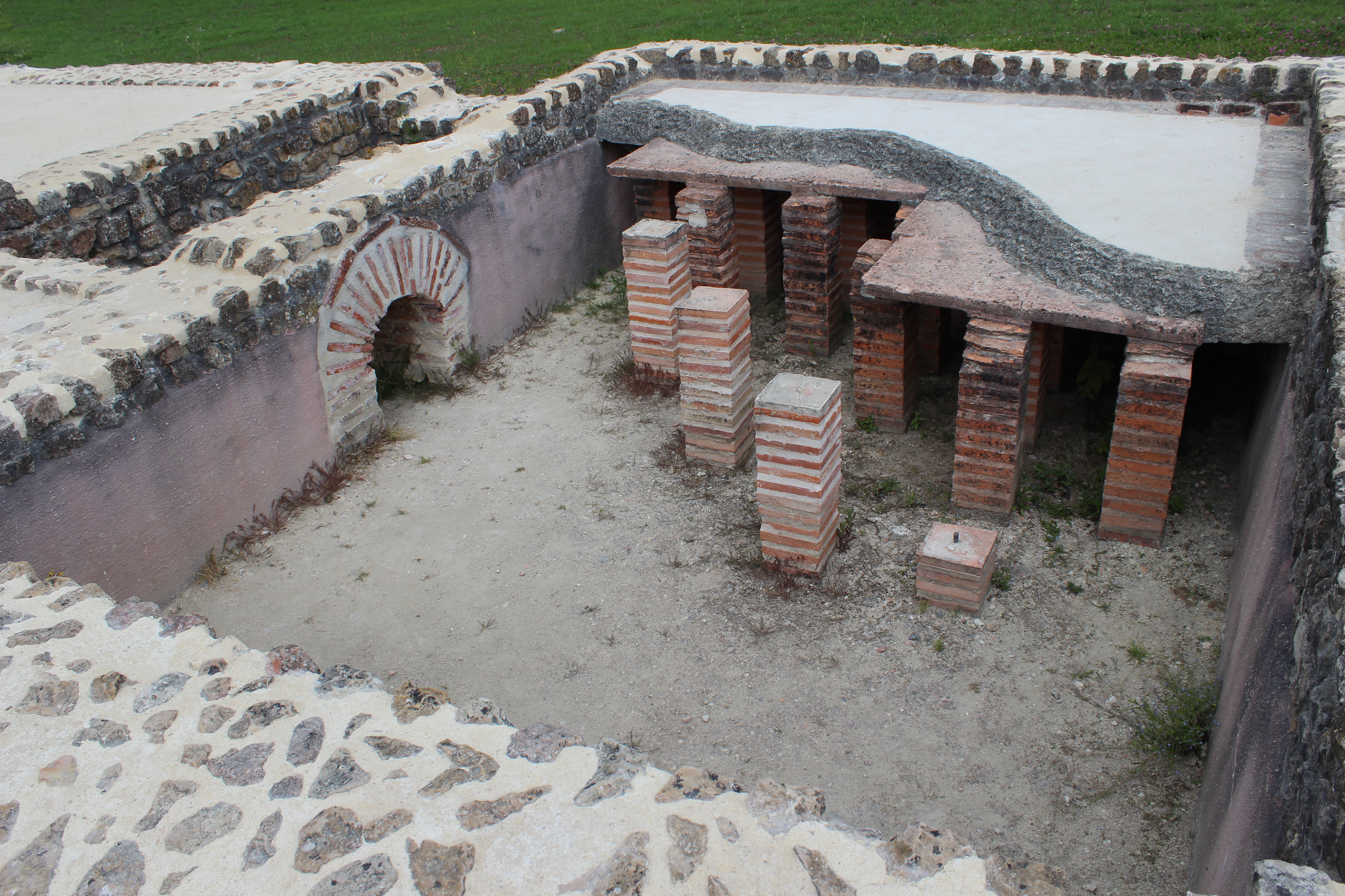
A hypocaust ( la, hypocaustum) is a system of central heating in a building that produces and circulates hot air below the floor of a room, and may also warm the walls with a series of pipes through which the hot air passes. This air can warm the upper floors as well. The word derives from the Ancient Greek meaning "under" and , meaning "burnt" (as in '' caustic''). The earliest reference to such a system suggests that the temple of Ephesus in 350 BC was heated in this manner, although Vitruvius attributes its invention to Sergius Orata in c. 80 BC. Its invention improved the hygiene and living conditions of citizens, and was a forerunner of modern central heating. Roman operation Hypocausts were used for heating hot baths and other public buildings in Ancient Rome. They were also used in private homes. It was a must for the villas of the wealthier merchant class throughout the Roman Empire. The ruins of Roman hypocausts have been found throughout Europe (for example in Ital ... [...More Info...] [...Related Items...] OR: [Wikipedia] [Google] [Baidu] |


