|
Auchallater
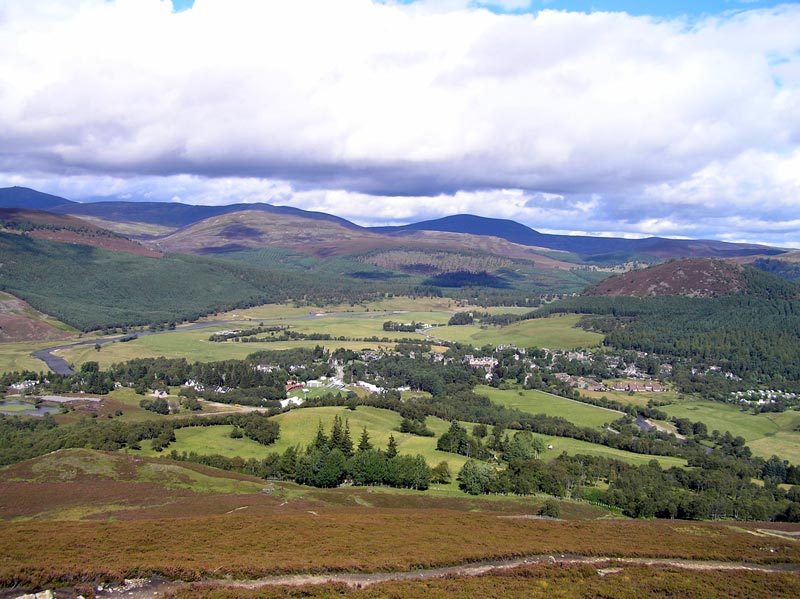
Auchallater is a hamlet in Aberdeenshire, Scotland. It lies along the A93 road, to the south of Braemar. Geography In 1872, the farms estates of Auchallater and Baddoch, including Newbigging and Coirenaleirg in the Auchallater estate, covered an area of . Geologically, grey garnetiferous schist is found in Auchallataer. Several streams run nearby, with the confluence of Clunie Water and Callater Burn in the vicinity and just to the west and Millstone Burn to the east. Loch Callater Loch Callater is an upland, freshwater loch lying approximately south of Braemar, Scotland. The loch trends in a northwest to southeast direction and is surrounded on both sides by steep hills. It is approximately in length. The loch was surve ... is also near, and is the source of Callater Burn. Economy A "little lairdship", Auchallatter is a sheepfarming hamlet. Auchallater Farm charge hikers for car parking near the south side of the bridge over Callater Burn. References Villages ... [...More Info...] [...Related Items...] OR: [Wikipedia] [Google] [Baidu] |
Clunie Water
Clunie Water is a river of Aberdeenshire, Scotland. It is a tributary of the River Dee, joining the river at Braemar, among grey stone buildings. Callater Burn is a tributary of the Clunie; the confluence is at Auchallater. The river flows alongside the A93 road. Bridges and pathways Further south of Auchallater in the Glen of Clunie is Fraser's Bridge, a long segmented arch bridge, measuring 15 ft 4 inches between its parapets. A Grade B listed building, it was completed in around 1749. On a 1776 Taylor and Skinner Map it was labelled "East Bridge". In June 2010, a new link path opened, leading from Highland Society Bridge over Clunie Water to the Glenshee Road. Fishing During the fishing season, from March to September, permits are granted for fishing brown trout The brown trout (''Salmo trutta'') is a European species of salmonid fish that has been widely introduced into suitable environments globally. It includes purely freshwater populations, referred to as th ... [...More Info...] [...Related Items...] OR: [Wikipedia] [Google] [Baidu] |
Aberdeenshire
Aberdeenshire ( sco, Aiberdeenshire; gd, Siorrachd Obar Dheathain) is one of the 32 Subdivisions of Scotland#council areas of Scotland, council areas of Scotland. It takes its name from the County of Aberdeen which has substantially different boundaries. The Aberdeenshire Council area includes all of the area of the Counties of Scotland, historic counties of Aberdeenshire and Kincardineshire (except the area making up the City of Aberdeen), as well as part of Banffshire. The county boundaries are officially used for a few purposes, namely land registration and Lieutenancy areas of Scotland, lieutenancy. Aberdeenshire Council is headquartered at Woodhill House, in Aberdeen, making it the only Scottish council whose headquarters are located outside its jurisdiction. Aberdeen itself forms a different council area (Aberdeen City). Aberdeenshire borders onto Angus, Scotland, Angus and Perth and Kinross to the south, Highland (council area), Highland and Moray to the west and Aber ... [...More Info...] [...Related Items...] OR: [Wikipedia] [Google] [Baidu] |
West Aberdeenshire And Kincardine (UK Parliament Constituency)
West Aberdeenshire and Kincardine is a county constituency of the House of Commons of the Parliament of the United Kingdom of Great Britain and Northern Ireland (Westminster), which elects one Member of Parliament (MP) by the first past the post system of election. It was first used in the 1997 general election, but has undergone boundary changes since that date. There was also a Holyrood constituency of West Aberdeenshire and Kincardine, a constituency of the Scottish Parliament, created in 1999 with the same boundaries as the Westminster constituency at that time. Boundaries 1997–2005: Kincardine and Deeside District, and the Gordon District electoral divisions of Donside and South Gordon. 2005–present: The area of the Aberdeenshire Council other than those parts in the Banff and Buchan County Constituency and the Gordon County Constituency. The constituency covers a southern portion of the Aberdeenshire council area. As redefined by the Fifth Periodical Review ... [...More Info...] [...Related Items...] OR: [Wikipedia] [Google] [Baidu] |
Aberdeenshire West (Scottish Parliament Constituency)
Aberdeenshire West (Gaelic: ''Siorrachd Obar Dheathain an Iar'') is a constituency of the Scottish Parliament ( Holyrood) covering part of the council area of Aberdeenshire. It elects one Member of the Scottish Parliament (MSP) by the first past the post method of election. Also, however, it is one of ten constituencies in the North East Scotland electoral region, which elects seven additional members, in addition to ten constituency MSPs, to produce a form of proportional representation for the region as a whole. The seat has been held by Alexander Burnett of the Scottish Conservatives since the 2016 Scottish Parliament election. Electoral region The other nine constituencies of the North East Scotland region are Aberdeen Central, Aberdeen Donside, Aberdeen South and North Kincardine, Aberdeenshire East, Angus North and Mearns, Angus South, Banffshire and Buchan Coast, Dundee City East and Dundee City West. The region covers all of the Aberdeen City council ... [...More Info...] [...Related Items...] OR: [Wikipedia] [Google] [Baidu] |
A93 Road
The A93 is a major road in Scotland and the highest public road in the United Kingdom. It runs north from Perth through Blairgowrie and Rattray, then through the Grampian Mountains by way of Glenshee, the Cairnwell Pass and Glen Clunie to Braemar in Aberdeenshire. At Braemar, the road then switches east down the strath of the River Dee before crossing the A90 and terminating in Aberdeen. Route Leaving Perth it passes Scone Palace, ancient coronation site of Scottish kings and now home to Britain's most northerly racecourse, continues through the planned 19th-century village of Guildtown before crossing the River Isla and passing the famous Meikleour Beech Hedge, planted to commemorate the 1715 Jacobite Rebellion and now the tallest hedge in the world. Five miles north lies Blairgowrie and Rattray, the largest town in Perthshire, where the road crosses the River Ericht. 6 miles up Glenericht it reaches the little village of Bridge of Cally and begins the long climb up into Glen ... [...More Info...] [...Related Items...] OR: [Wikipedia] [Google] [Baidu] |
Braemar
Braemar is a village in Aberdeenshire, Scotland, around west of Aberdeen in the Highlands. It is the closest significantly-sized settlement to the upper course of the River Dee sitting at an elevation of . The Gaelic ''Bràigh Mhàrr'' properly refers to the area of upper Marr (as it literally means), i.e. the area of Marr to the west of Aboyne, the village itself being Castleton of Braemar (''Baile a' Chaisteil''). The village used to be known as ''Cinn Drochaid'' (bridge end); ''Baile a' Chaisteil'' referred to only the part of the village on the east bank of the river, the part on the west bank being known as ''Ach an Droighinn'' (thorn field). Geography Braemar is approached from the South on the A93 from Glen Clunie and the Cairnwell Pass and from the East also on the A93 from Deeside. Braemar can be approached on foot from the West through Glen Tilt, Glen Feshie, Glen Dee (by the Lairig Ghru), and Glen Derry (by the Lairig an Laoigh). Braemar is within a one-and-a-hal ... [...More Info...] [...Related Items...] OR: [Wikipedia] [Google] [Baidu] |
Millstone Burn
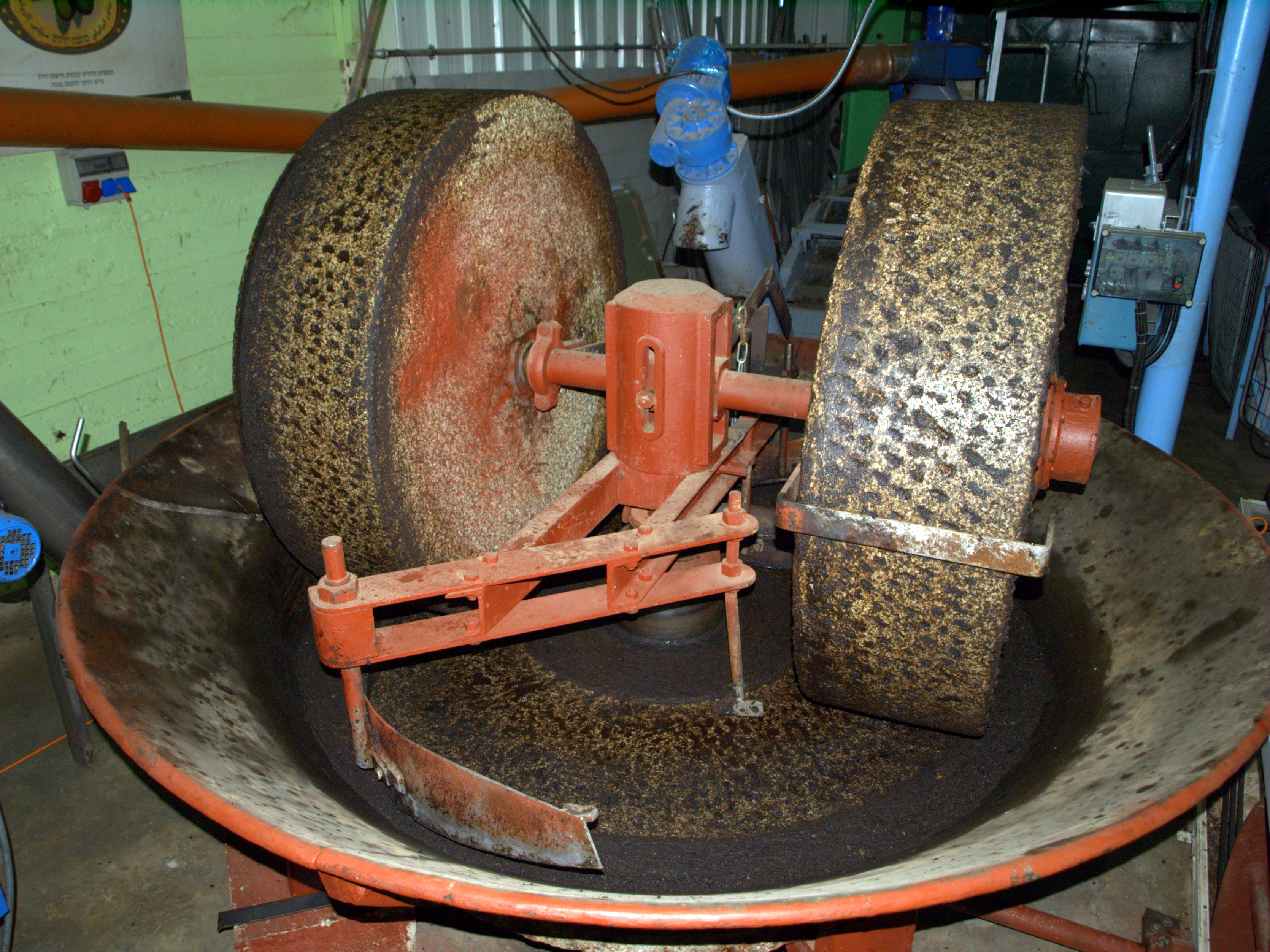
Millstones or mill stones are stones used in gristmills, for grinding wheat or other grains. They are sometimes referred to as grindstones or grinding stones. Millstones come in pairs: a convex stationary base known as the ''bedstone'' and a concave ''runner stone'' that rotates. The movement of the runner on top of the bedstone creates a "scissoring" action that grinds grain trapped between the stones. Millstones are constructed so that their shape and configuration help to channel ground flour to the outer edges of the mechanism for collection. The runner stone is supported by a cross-shaped metal piece ( millrind or rynd) fixed to a "mace head" topping the main shaft or spindle leading to the driving mechanism of the mill ( wind, water (including tide) or other means). History The earliest evidence for stones used to grind food is found in northern Australia, at the Madjedbebe rock shelter in Arnhem Land, dating back around 60,000 years. Grinding stones or g ... [...More Info...] [...Related Items...] OR: [Wikipedia] [Google] [Baidu] |
Loch Callater
Loch Callater is an upland, freshwater loch lying approximately south of Braemar, Scotland. The loch trends in a northwest to southeast direction and is surrounded on both sides by steep hills. It is approximately in length. The loch was surveyed on 11 July 1905 by T.N. Johnston and L.W. Collett and later charted as part of the Sir John Murray's ''Bathymetrical Survey of Fresh-Water Lochs of Scotland 1897-1909''. Trout, salmon, eels and perch are found in the loch. A permit is required for fishing. The loch and surrounding area is popular with walkers and at the north end is the ''Callater Stable'' walkers' bothy A bothy is a basic shelter, usually left unlocked and available for anyone to use free of charge. It was also a term for basic accommodation, usually for gardeners or other workers on an estate. Bothies are found in remote mountainous areas of Sco .... References {{reflist Callater Callater Dee Basin ... [...More Info...] [...Related Items...] OR: [Wikipedia] [Google] [Baidu] |


