|
Annexation Bill Of 1866
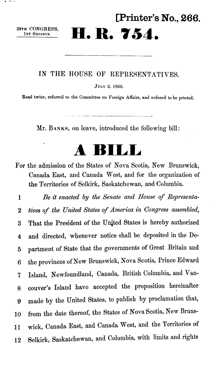
The Annexation Bill of 1866 was a bill introduced on July 2, 1866, but never passed in the United States House of Representatives. It called for the annexation of British North America and the admission of its provinces as states and territories in the Union. The bill was sent to committee but never came back, was never voted upon, and did not become law. The bill never came to the United States Senate. The bill authorized the President of the United States to, subject to the agreement of the governments of the British provinces, "publish by proclamation that, from the date thereof, the States of Nova Scotia, New Brunswick, Canada East, and Canada West, and the Territories of Selkirk, Saskatchewan, and Columbia, with limits and rights as by the act defined, are constituted and admitted as States and Territories of the United States of America." It provided for the admission of all the colonies and the purchase of the Hudson's Bay Company's lands for $10,000,000. The Am ... [...More Info...] [...Related Items...] OR: [Wikipedia] [Google] [Baidu] |
Confederate States Of America
The Confederate States of America (CSA), commonly referred to as the Confederate States or the Confederacy was an unrecognized breakaway republic in the Southern United States that existed from February 8, 1861, to May 9, 1865. The Confederacy comprised U.S. states that declared secession and warred against the United States during the American Civil War: South Carolina, Mississippi, Florida, Alabama, Georgia, Louisiana, Texas, Virginia, Arkansas, Tennessee, and North Carolina. Kentucky and Missouri also declared secession and had full representation in the Confederate Congress, though their territory was largely controlled by Union forces. The Confederacy was formed on February 8, 1861, by seven slave states: South Carolina, Mississippi, Florida, Alabama, Georgia, Louisiana, and Texas. All seven were in the Deep South region of the United States, whose economy was heavily dependent upon agriculture—particularly cotton—and a plantation system that relied upon enslaved ... [...More Info...] [...Related Items...] OR: [Wikipedia] [Google] [Baidu] |
Southern Ontario
Southern Ontario is a primary region of the province of Ontario, Canada, the other primary region being Northern Ontario. It is the most densely populated and southernmost region in Canada. The exact northern boundary of Southern Ontario is disputed; however, the core region is situated south of Algonquin Park, the latter being in an area of transition between coniferous forest north of the French and Mattawa Rivers and southern deciduous forest. It covers between 14 and 15% of the province, depending on the inclusion of the Parry Sound and Muskoka districts which also lie in the transitional area between northern and southern forest regions. With approximately 13.5 million people, the region is home to approximately 36% of Canada's population of 37.0 million. Southern Ontario differs greatly from Northern Ontario, in that it has a much higher population density, a different climate, and a different culture than its northern counterpart. It is broken into smaller subregions, i ... [...More Info...] [...Related Items...] OR: [Wikipedia] [Google] [Baidu] |
Northern Ontario
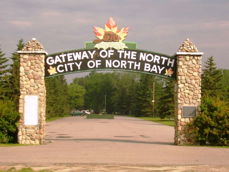
Northern Ontario is a primary geographic and quasi-administrative region of the Canadian province of Ontario, the other primary region being Southern Ontario. Most of the core geographic region is located on part of the Superior Geological Province of the Canadian Shield, a vast rocky plateau located mainly north of Lake Huron (including Georgian Bay), the French River, Lake Nipissing, and the Mattawa River. The statistical region extends south of the Mattawa River to include all of the District of Nipissing. The southern section of this district lies on part of the Grenville Geological Province of the Shield which occupies the transitional area between Northern and Southern Ontario. The extended federal and provincial quasi-administrative regions of Northern Ontario have their own boundaries even further south in the transitional area that vary according to their respective government policies and requirements. Ontario government departments and agencies such as the Growth Pl ... [...More Info...] [...Related Items...] OR: [Wikipedia] [Google] [Baidu] |
Newfoundland And Labrador
Newfoundland and Labrador (; french: Terre-Neuve-et-Labrador; frequently abbreviated as NL) is the easternmost province of Canada, in the country's Atlantic region. The province comprises the island of Newfoundland and the continental region of Labrador, having a total size of 405,212 square kilometres (156,500 sq mi). In 2021, the population of Newfoundland and Labrador was estimated to be 521,758. The island of Newfoundland (and its smaller neighbouring islands) is home to around 94 per cent of the province's population, with more than half residing in the Avalon Peninsula. Labrador borders the province of Quebec, and the French overseas collectivity of Saint Pierre and Miquelon lies about 20 km west of the Burin Peninsula. According to the 2016 census, 97.0 per cent of residents reported English as their native language, making Newfoundland and Labrador Canada's most linguistically homogeneous province. A majority of the population is descended from English and Irish s ... [...More Info...] [...Related Items...] OR: [Wikipedia] [Google] [Baidu] |
Quebec
Quebec ( ; )According to the Canadian government, ''Québec'' (with the acute accent) is the official name in Canadian French and ''Quebec'' (without the accent) is the province's official name in Canadian English is one of the thirteen provinces and territories of Canada. It is the largest province by area and the second-largest by population. Much of the population lives in urban areas along the St. Lawrence River, between the most populous city, Montreal, and the provincial capital, Quebec City. Quebec is the home of the Québécois nation. Located in Central Canada, the province shares land borders with Ontario to the west, Newfoundland and Labrador to the northeast, New Brunswick to the southeast, and a coastal border with Nunavut; in the south it borders Maine, New Hampshire, Vermont, and New York in the United States. Between 1534 and 1763, Quebec was called ''Canada'' and was the most developed colony in New France. Following the Seven Years' War, Quebec b ... [...More Info...] [...Related Items...] OR: [Wikipedia] [Google] [Baidu] |
Prince Edward Island
Prince Edward Island (PEI; ) is one of the thirteen Provinces and territories of Canada, provinces and territories of Canada. It is the smallest province in terms of land area and population, but the most densely populated. The island has several nicknames: "Garden of the Gulf", "Birthplace of Confederation" and "Cradle of Confederation". Its capital and largest city is Charlottetown. It is one of the three Maritime provinces and one of the four Atlantic provinces. Part of the traditional lands of the Miꞌkmaq, it was colonized by the French in 1604 as part of the colony of Acadia. The island was ceded to the British at the conclusion of the French and Indian War in 1763 and became part of the colony of Nova Scotia, and in 1769 the island became its own British colony. Prince Edward Island hosted the Charlottetown Conference in 1864 to discuss a Maritime Union, union of the Maritime provinces; however, the conference became the first in a series of meetings which led to Canadi ... [...More Info...] [...Related Items...] OR: [Wikipedia] [Google] [Baidu] |
Unorganized Area
An unorganized area or unorganized territory (french: Territoire non organisé) is any geographic region in Canada that does not form part of a municipality or Indian reserve. In these areas, the lowest level of government is provincial or territorial. In some of these areas, local service agencies may have some of the responsibilities that would otherwise be covered by municipalities. British Columbia Most regional districts in British Columbia include some electoral areas, which are unincorporated areas that do not have their own municipal government, but residents of such areas still receive a form of local government by electing representatives to their regional district boards. The Stikine Region in the province's far northwest is the only part of British Columbia not in a regional district, because of its low population and the lack of any incorporated municipalities. The Stikine Region—not to be confused with the Stikine Country or the Kitimat-Stikine Regional Distri ... [...More Info...] [...Related Items...] OR: [Wikipedia] [Google] [Baidu] |
Arctic Archipelago
The Arctic Archipelago, also known as the Canadian Arctic Archipelago, is an archipelago lying to the north of the Canadian continental mainland, excluding Greenland (an autonomous territory of Denmark). Situated in the northern extremity of North America and covering about , this group of 36,563 islands, surrounded by the Arctic Ocean, comprises much of Northern Canada, predominately Nunavut and the Northwest Territories. The archipelago is showing some effects of climate change, with some computer estimates determining that melting there will contribute to the rise in sea levels by 2100. History Around 2500 BCE, the first humans, the Paleo-Eskimos, arrived in the archipelago from the Canadian mainland. Between 1000–1500 CE, they were replaced by the Thule people, who are the ancestors of today's Inuit. British claims on the islands, the British Arctic Territories, were based on the explorations in the 1570s by Martin Frobisher. Canadian sovereignty was originally (187 ... [...More Info...] [...Related Items...] OR: [Wikipedia] [Google] [Baidu] |
Bahamas And The American Civil War
Despite being a territory of the British Empire, the Bahamas was affected by the American Civil War. Much as it was during the Golden Age of Piracy, the Bahamas was a haven for swashbucklers and blockade runners that were aligned with the Confederate States. Although Florida is only 55 miles away, the state then had few ports of any real consequence and so blockade runners would make their trips from Nassau to Charleston, South Carolina, the largest Confederate port on the East Coast. Grand Bahama Island had a decreasing population in the 19th century because of Nassau, but after the Civil War began in 1861, Grand Bahama Island's population doubled because of the blockade runners' actions. Nassau was also altered by the war. The first blockade runner docked there on December 5, 1861. By the end of the war, 397 ships sailed from the Confederacy to Nassau, and 588 went from Nassau to the Confederacy. Nassau imports were valued at £234,029, and its exports were worth £157,35 ... [...More Info...] [...Related Items...] OR: [Wikipedia] [Google] [Baidu] |
Canada And The American Civil War
At the time of the American Civil War (1861–1865), Canada did not yet exist as a federated nation. Instead, British North America consisted of the Province of Canada (parts of modern southern Ontario and southern Quebec) and the separate colonies of Newfoundland, New Brunswick, Prince Edward Island, Nova Scotia, British Columbia and Vancouver Island, as well as a crown territory administered by the Hudson's Bay Company called Rupert's Land. Britain and its colonies were officially neutral for the duration of the war. Despite this, tensions between Britain and the United States were high due to incidents on the seas, such as the '' Trent'' Affair and the Confederate commissioning of the CSS ''Alabama'' from Britain. Canadians were largely opposed to slavery, and Canada had recently become the terminus of the Underground Railroad. Close economic and cultural links across the long border, also encouraged Canadian sympathy towards the Union. Between 33,000 and 55,000 men from ... [...More Info...] [...Related Items...] OR: [Wikipedia] [Google] [Baidu] |
Confederate Secret Service
The Confederate Secret Service refers to any of a number of official and semi-official secret service organizations and operations conducted by the Confederate States of America during the American Civil War. Some of the organizations were under the direction of the Confederate government, others operated independently with government approval, while still others were either completely independent of the government or operated with only its tacit acknowledgment. By 1864, the Confederate government was attempting to gain control over the various operations that had sprung up since the beginning of the war, but often with little success. Secret legislation was put before the Confederate Congress to create an official Special and Secret Bureau of the War Department. The legislation was not enacted until March 1865 and was never implemented; however, a number of groups and operations have historically been referred to as having been part of the Confederate Secret Service. In April 1865 ... [...More Info...] [...Related Items...] OR: [Wikipedia] [Google] [Baidu] |


