|
Annai Airport
Annai Airport is an airport serving the village of Annai, in the Upper Takutu-Upper Essequibo Region of Guyana. The runway has of asphalt paving, with the remainder grass. It is a small, hinterland airport that serves Guyana's tourism sector. Since 2019, Annai utilizes the Automatic Dependent Surveillance Broadcast System (ADSB) for tracking planes. See also * * * List of airports in Guyana * Transport in Guyana The transport sector comprises the physical infrastructure, docks and vehicle, terminals, fleets, ancillary equipment and service delivery of all the various modes of transport operating in Guyana. The transport services, transport agencies providi ... References Airports in Guyana {{Guyana-airport-stub ... [...More Info...] [...Related Items...] OR: [Wikipedia] [Google] [Baidu] |
Annai, Guyana
Annai is an Amerindian village in the Upper Takutu-Upper Essequibo Region of Guyana. Annai stands at an altitude of 95 metres (314 feet), at the edge of the Rupununi savannah, where the cattle trail to the Atlantic coast begins. It is nestled in the foothills of the Pakaraima Mountains, and is close to the Rupununi River. Annai, considered to be the gateway to the Rupununi, is approximately north of Karanambo and is by road from the nation's capital, Georgetown. Much of the population of the area are members of the Macushi people. Annai is one of the northernmost Macushi Amerindian villages in the North Rupununi Savannahs. It is mainly an agriculture community living on cassava and peanut farming, and cattle ranching. Electricity is provided by solar power. Public services include a nursery, primary, and secondary school as well as a public health centre. Annai's airstrip ( NAI) allows light planes to land. Annai is home to the Rock View Ecotourism Resort, an old ranch bu ... [...More Info...] [...Related Items...] OR: [Wikipedia] [Google] [Baidu] |
Upper Takutu-Upper Essequibo
Upper Takutu-Upper Esequibo (Region 9) is a Regions of Guyana, region of Guyana. Venezuela claims the territory as part of Bolívar (state) in Guayana Esequiba, Esequiban Guyana. It borders the region of Potaro-Siparuni to the north, the region of East Berbice-Corentyne to the east and Brazil to the south and west. It contains the town of Lethem, Guyana, Lethem, and the villages of Aishalton, Nappi, Guyana, Nappi and Surama. It is also the largest region of Guyana. The Rupununi savannah known for its large biodiversity is located between the Rupununi River and the Brazilian border. Population The Government of Guyana has administered three official censuses since the 1980 administrative reforms, in 1980, 1991 and 2002. In 2012, the population of Upper Takutu-Upper Essequibo was recorded at 24,212 people. Official census records for the population of the Upper Takutu-Upper Essequibo region are as follows: *2012 : 24,212 *2002 : 19,387 *1991 : 15,058 *1980 : 12,873 Communities ... [...More Info...] [...Related Items...] OR: [Wikipedia] [Google] [Baidu] |
Guyana
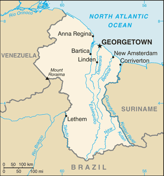
Guyana ( or ), officially the Cooperative Republic of Guyana, is a country on the northern mainland of South America. Guyana is an indigenous word which means "Land of Many Waters". The capital city is Georgetown. Guyana is bordered by the Atlantic Ocean to the north, Brazil to the south and southwest, Venezuela to the west, and Suriname to the east. With , Guyana is the third-smallest sovereign state by area in mainland South America after Uruguay and Suriname, and is the second-least populous sovereign state in South America after Suriname; it is also one of the least densely populated countries on Earth. It has a wide variety of natural habitats and very high biodiversity. The region known as "the Guianas" consists of the large shield landmass north of the Amazon River and east of the Orinoco River known as the "land of many waters". Nine indigenous tribes reside in Guyana: the Wai Wai, Macushi, Patamona, Lokono, Kalina, Wapishana, Pemon, Akawaio and Warao. Histo ... [...More Info...] [...Related Items...] OR: [Wikipedia] [Google] [Baidu] |
List Of Airports In Guyana
This is a list of airports in Guyana, sorted by location. Guyana, officially the Co-operative Republic of Guyana and previously known as British Guiana, is a state on the northern coast of South America. Guyana is bordered to the east by Suriname, to the south and southwest by Brazil, to the west by Venezuela, and to the north by the Atlantic Ocean. It is the only state of the Commonwealth of Nations on mainland South America. Guyana is also a member of the Caribbean Community (CARICOM), which has its secretariat headquarters in Guyana's capital, Georgetown. __TOC__ Airports Airport names shown in bold have scheduled passenger service on commercial airlines. See also * Transport in Guyana * List of airports by ICAO code: S#SY - Guyana * Wikipedia: WikiProject Aviation/Airline destination lists: South America#Guyana References * * - includes IATA codes Airports in Guyana World Aero Data. - ICAO codes, airport data Airports in Guyana Great Circle Mapper. - IATA and ... [...More Info...] [...Related Items...] OR: [Wikipedia] [Google] [Baidu] |
Transport In Guyana
The transport sector comprises the physical infrastructure, docks and vehicle, terminals, fleets, ancillary equipment and service delivery of all the various modes of transport operating in Guyana. The transport services, transport agencies providing these services, the organizations and people who plan, build, maintain, and operate the system, and the policies that mold its development. City transportation Public transport around Guyana's capital Georgetown is provided by privately owned mini buses which operate in allocated zones for which there is a well-regulated fare structure. This arrangement extends to all mini bus routes throughout the country. There are designated bus stops for mini buses for most routes but some buses still pick up passengers at virtually any point on their routes. This practice often poses a serious inconvenience to other vehicles by disrupting the normal flow of traffic. Taxis have freer movement around the city and into rural areas. Their fare, whil ... [...More Info...] [...Related Items...] OR: [Wikipedia] [Google] [Baidu] |

