|
Alaska Central Express
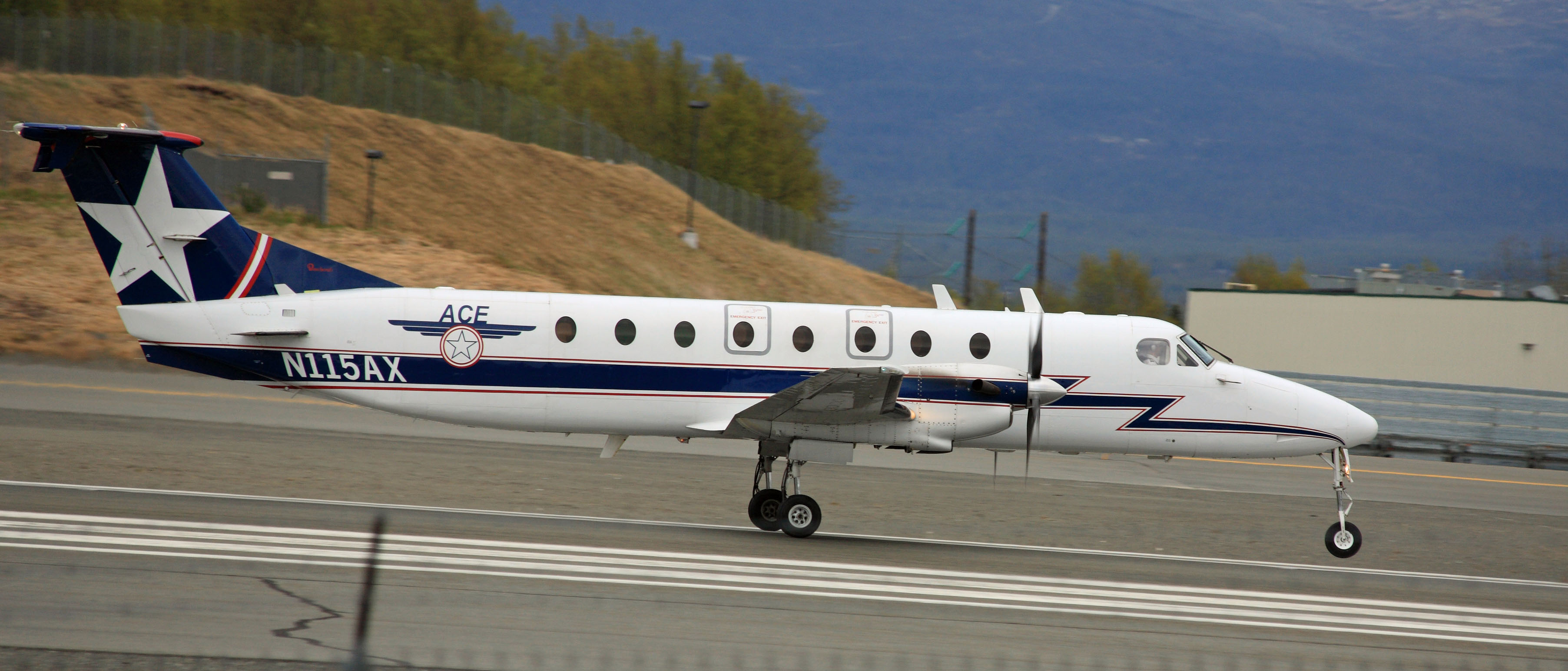
Alaska Central Express is an airline based at Ted Stevens Anchorage International Airport in Anchorage, Alaska, United States. It is a cargo and small package express service. History The airline was established as Yutana Airlines in 1987 and renamed to Alaska Central Express in 1994 when the certificate was bought from the Part 135 in Fairbanks, Alaska. Much of the original pilots, staff, mechanics, and equipment including three Raytheon Beechcraft 1900Cs came from MarkAir Express, a subsidiary of the bankrupt MarkAir. In 2007 with the purchase of a Beech 1900C (N115AX) combi passenger/cargo, ACE Air Cargo began charter passenger flights. Alaska Central Express, as of 2020, owns fifteen airplanes with plans for future expansion. Destinations Alaska Central Express operates freight services to the following domestic scheduled destinations (at January 2005): Anchorage, Aniak, Atmautluak, Bethel, Chefornak, Chevak, Cold Bay, Dillingham, Dutch Harbor, Eek, Hooper Bay, Ju ... [...More Info...] [...Related Items...] OR: [Wikipedia] [Google] [Baidu] |
Ted Stevens Anchorage International Airport
Ted Stevens Anchorage International Airport is a major airport in the U.S. state of Alaska, located southwest of downtown Anchorage. The airport is named for Ted Stevens, a U.S. senator from Alaska in office from 1968 to 2009. It is included in the Federal Aviation Administration (FAA) National Plan of Integrated Airport Systems for 2017–2021, in which it is categorized as a medium-hub primary commercial service facility. History Built in 1951, the airport was served in the 1950s by Alaska Airlines, Northwest Orient, Pacific Northern Airlines and Reeve Aleutian Airways, using aircraft ranging from Douglas DC-3s to Boeing 377s, and was also a refueling stop for Canadian Pacific Air Lines service to the Far East (one such aircraft being involved in a 1951 disappearance). From 1955 to 2011, the eastern end of the airport's southernmost runway connected to the Kulis Air National Guard Base. By the mid-1980s the airport's nickname was "Crossroads of the World". Anchorage was ... [...More Info...] [...Related Items...] OR: [Wikipedia] [Google] [Baidu] |
Dutch Harbor
Dutch Harbor is a harbor on Amaknak Island in Unalaska, Alaska. It was the location of the Battle of Dutch Harbor in June 1942, and was one of the few sites in the United States to be subjected to aerial bombardment by a foreign power during World War II. It was also one of the few sites, besides the attack on Pearl Harbor in Hawaii, in incorporated U.S. territory to be bombed by the Japanese in the war. Dutch Harbor is now the home of an important fishing industry. Russian to American Druzhinin, the commander of the Russian ship ''Zakharii I Elisaveta'', is credited for discovering the deep-water harbor now known as Dutch Harbor. Dutch Harbor is located within the Aleutian Islands of Alaska, more precisely on Amaknak Island in the Fox Islands. A mile long spit extending from the northeast end of Amaknak Island makes Dutch Harbor a natural port, protecting ships from the waves and currents of the Bering Sea, although winds off the Bering Sea have tossed shipments from decks of ... [...More Info...] [...Related Items...] OR: [Wikipedia] [Google] [Baidu] |
Petersburg, Alaska
Petersburg (Tlingit language, Tlingit: ''Séet Ká'' or ''Gantiyaakw Séedi'' "Steamboat Channel") is a census-designated place (CDP) in and essentially the borough seat of Petersburg Borough, Alaska, Petersburg Borough, Alaska, United States. The population was 3,043 at the 2020 United States census, 2020 census, up from 2,948 in 2010. The borough encompasses Petersburg and Kupreanof, Alaska, Kupreanof, plus mostly uninhabited areas stretching to the Canada–United States border, Canadian–American border and the southern boundary of the City and Juneau, Alaska, Borough of Juneau. While the city of Petersburg ceased to exist as a separate administrative entity (the borough assembly created a service area to assume operation of the former city's services), the tiny city of Kupreanof remains separate within the borough. History Tlingit people, Tlingits from Kupreanof Island had long used a summer fish camp at the north end of Mitkof Island. Earlier cultures of indigenous people ... [...More Info...] [...Related Items...] OR: [Wikipedia] [Google] [Baidu] |
Nightmute, Alaska
Nightmute ( esu, Negtemiut or ) is a city and village in Bethel Census Area, Alaska, United States. The population was 208 at the 2000 census and 280 as of the 2010 census. History literally means ‘the people of the pressed-down place’. The first element is ‘to press down on’. The suffix is ‘people’. It first appeared on the 1940 U.S. Census as the unincorporated native village of "Nigtmuit". In 1950 and 1960, it was spelled "Nigtmute". In 1970, the spelling used was "Nightmute". It formally incorporated in 1974. In 1964, many of its residents relocated by dogsled and founded the bayside community of Toksook Bay about downriver. The relocation was to avoid the yearly spring-winter migration to and from Umkumiut and Nightmute. Geography Nightmute is located on Nelson Island near Toksook Bay. The two villages connect by snowmachine trail in winter. According to the United States Census Bureau, the city has a total area of , of which is land and (4. ... [...More Info...] [...Related Items...] OR: [Wikipedia] [Google] [Baidu] |
Newtok, Alaska
Newtok ( esu, Niugtaq) is a small village on the Ningliq River in the Bethel Census Area, Alaska, United States. At the 2010 census, the population was 354, up from 321 in 2000. Climate change is forcing the primarily Central Yup'ik Alaska Native village to consider relocation. Mertarvik is the destination of those leaving the village. Geography According to the United States Census Bureau, the CDP has a total area of , of which, of it is land and of it (7.21%) is water. Demographics Newtok first appeared on the 1950 U.S. Census as "Keyaluvik", an unincorporated native village. This was also the name of the earlier settlement just to the west, which became known as "Old Keyaluvik." In 1960, the name was changed to Newtok. Newtok formally incorporated in 1976, but disincorporated in 1997. It was then made a census-designated place (CDP), effective with the 2000 census. As of the census of 2000, there were 321 people, 63 households, and 51 families residing in the CDP. Th ... [...More Info...] [...Related Items...] OR: [Wikipedia] [Google] [Baidu] |
Marshall, Alaska
Marshall ( esu, Masserculleq) is a city in Kusilvak Census Area, Alaska, United States. At the 2010 census the population was 414, up from 349 in 2000. Geography Marshall is located at . According to the United States Census Bureau, the city has a total area of , all of it land. Demographics The predecessor village to Marshall first appeared on the 1880 U.S. Census as the Inuit village of "Ooglovia." It was also known as Uglovaia. It would not appear again on the census. Marshall first appeared on the 1940 U.S. Census as the unincorporated village of Fortuna Ledge. In 1950, the name was changed to Marshall. It continued to return as Marshall in 1960 and 1970, but in the latter year incorporated as the city of Fortuna Ledge. It reported as Fortuna Ledge on the 1980 census, but the city reverted to the name of Marshall in 1984. It has continued to report as Marshall since the 1990 census. As of the census of 2000, there were 349 people, 91 households, and 73 families residing i ... [...More Info...] [...Related Items...] OR: [Wikipedia] [Google] [Baidu] |
Kwigillingok, Alaska
Kwigillingok ( esu, Kuigilnguq) is a census-designated place (CDP) in Bethel Census Area, Alaska, United States. The population was 321 at the 2010 census, down from 338 in 2000. Geography Kwigillingok is located at . According to the United States Census Bureau, the CDP has a total area of , of which, of it is land and of it (0.35%) is water. Demographics Kwigillingok first appeared on the 1920 U.S. Census as Quigillingok, an unincorporated native village. It did not appear on the 1930 census, but was returned as "Quigilinook" in 1940. In 1950, the name was changed to the present spelling of Kwigillingok. It was made a census-designated place in 1980. As of the census of 2000, there were 388 people, 96 households, and 89 families residing in the CDP. The population density was 16.8 people per square mile (6.5/km2). There were 78 housing units at an average density of 3.9/sq mi (1.5/km2). The racial makeup of the CDP was 2.07% White, 97.63% Native American, and 0.3 ... [...More Info...] [...Related Items...] OR: [Wikipedia] [Google] [Baidu] |
Kongiganak, Alaska
Kongiganak ( esu, Kangirnaq) is a census-designated place (CDP) in Bethel Census Area, Alaska, United States, and primarily sits on the eastern shore of the Kongiganak River. As of the 2010 United States Census, 2010 census, the population was 439, up from 359 in 2000. Geography Kongiganak is located at (59.953896, -162.895199). According to the United States Census Bureau, the CDP has a total area of , of which are land and (9.14%) is water. History The original Kongiganak was settled in the 19th century and was located on a small creek just above Kuskokwim Bay. In 1880, it was called "Kongiganagamute" and had a population of 175 Inuit. The site was later abandoned. It is located a few miles east of present-day Kwigillingok and about 9 miles southeast of the current Kongiganak. The current Kongiganak was permanently settled in the 1960s when former residents of Kwigillingok sought higher ground in search of relief from floods. It is served by Kongiganak Airport. Demographi ... [...More Info...] [...Related Items...] OR: [Wikipedia] [Google] [Baidu] |
Kodiak Island Borough, Alaska
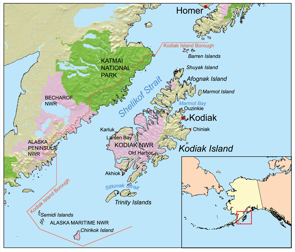
Kodiak Island Borough (russian: Остров Кадьяк) is a borough in the U.S. state of Alaska. At the 2020 census, the population was 13,101, down from 13,592 in 2010. The borough seat is Kodiak. Geography The borough has a total area of , of which is land and (45.5%) is water. Most of the land area belongs to Kodiak Island, but a thin strip of coastal area on the western part of the Alaska Peninsula and other nearby islands (Afognak Island, Shuyak Island, Marmot Island, Raspberry Island, Little Raspberry Island, Whale Island, Spruce Island, Woody Island, Uganik Island, Sitkalidak Island, Tugidak Island, Sitkinak Island, Chirikof Island, and the Semidi Islands) are also in the borough. The waterway between the island and mainland is known as the Shelikof Strait. South of the island are the open waters of the Pacific Ocean, so the site is considered good for launching certain types of satellites. The Kodiak Launch Complex is ideal for putting satellites i ... [...More Info...] [...Related Items...] OR: [Wikipedia] [Google] [Baidu] |
Kipnuk, Alaska
Kipnuk ( esu, Qipneq) is a census-designated place (CDP) in Bethel Census Area, Alaska, United States. At the 2010 census the population was 639, down from 644 in 2000. Kipnuk consists mostly of Yup'ik speaking Native Alaskans; the name means a "bend" referring to the bend in the (Qukaqliq) Kugkaktlik River where it is situated. The original settlement was situated along "Nukallpiarcunarli", a slough feeding into the (Qukaqliq) Kugkaktlik. This slough was thus named, because it was hard to detect. It was ideal for ambushing "Nukallpiaqs" or warrior/providers. Geography Kipnuk is located at (59.937619, -164.043926). According to the United States Census Bureau, the CDP has a total area of , of which, of it is land and of it (1.22%) is water. Kipnuk is served by Kipnuk Airport. Demographics Kipnuk first appeared on the 1940 U.S. Census as an unincorporated native village. It was made a census-designated place (CDP) as of the 1980 census. As of the census of 2000, there were ... [...More Info...] [...Related Items...] OR: [Wikipedia] [Google] [Baidu] |
King Salmon, Alaska
King Salmon is a census-designated place (CDP) in Bristol Bay Borough in the U.S. state of Alaska. It is southwest of Anchorage. As of the 2020 census the population was 307, down from 374 in 2010. It is home to Katmai National Park and Preserve. King Salmon is the borough seat of neighboring Lake and Peninsula Borough, but does not serve that purpose in its own borough, whose borough seat is in Naknek. Geography King Salmon is on the north bank of the Naknek River on the Alaska Peninsula, about upriver from Naknek, near Naknek Lake. According to the United States Census Bureau, the CDP has an area of , of which, is land and (0.82%) is water. Climate King Salmon has a subarctic climate (Köppen ''Dfc'') even though it is at 58° North. Temperatures, especially extreme ones, are much less moderate than in the subpolar oceanic climate of the Pacific Ocean side of the Alaska Peninsula; however, average temperatures in winter are still milder than some locations in the cotermin ... [...More Info...] [...Related Items...] OR: [Wikipedia] [Google] [Baidu] |
Ketchikan, Alaska
Ketchikan ( ; tli, Kichx̱áan) is a city in and the borough seat of the Ketchikan Gateway Borough of Alaska. It is the state's southeasternmost major settlement. Downtown Ketchikan is a National Historic District. With a population at the 2020 census of 8,192, up from 8,050 in 2010, it is the sixth-most populous city in the state, and thirteenth-most populous community when census-designated places are included. The surrounding borough, encompassing suburbs both north and south of the city along the Tongass Highway (most of which are commonly regarded as a part of Ketchikan, albeit not a part of the city itself), plus small rural settlements accessible mostly by water, registered a population of 13,948 in that same census. Incorporated on August 25, 1900, Ketchikan is the earliest extant incorporated city in Alaska, because consolidation or unification elsewhere in Alaska resulted in the dissolution of those communities' city governments. Ketchikan is located on Revillagige ... [...More Info...] [...Related Items...] OR: [Wikipedia] [Google] [Baidu] |

.jpg)
.jpg)


.jpeg)