|
Akbet
Akbet ( kk, Ақбет) is a mountain in Bayanaul District, Pavlodar Region, Kazakhstan. Akbet is located about to the NNW of Bayanaul. According to local folklore, the mountain is named after a Kazakh girl who killed herself there after having been given in marriage to a man she did not love. Geography Akbet rises in the Bayanaul Range, a subrange of the Kazakh Uplands (Saryarka). The mountain has generally gentle slopes, but rocky and strongly dissected on the western side, where there is a gorge with springs. With an elevation , it is the highest mountain in the Bayanaul Range, as well as the highest point of Pavlodar Region.''Kazakhstan National Encyclopedia'' / Ch. ed. B.O. Jakyp. — Almaty: «Kazakh encyclopedia» ZhSS, 2011. ISBN 9965-893-64-0(T.Z.),ISBN 9965-893-19-5 Geologically the peak is made up of Silurian and Devonian granite, syenite, porphyry and shale. See also *Geography of Kazakhstan Kazakhstan is located in Central Asia (with 14% of the country in E ... [...More Info...] [...Related Items...] OR: [Wikipedia] [Google] [Baidu] |
Bayanaul Range
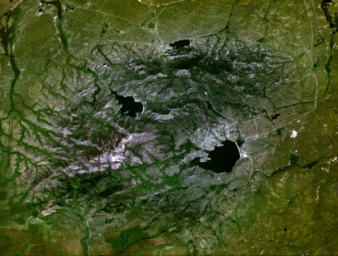
Bayanaul Range ( kk, Баянауыл тауы; russian: Баянаульские горы) is a range of mountains in Bayanaul District, Pavlodar Region, Kazakhstan.Kanysh Satpaev. Encyclopedia / Editor-in-Chief B. O. Jakyp. — Almaty "Kazakh Encyclopedia", 2011. ISBN 9965-893-74-8 Bayanaul, the administrative center of Bayanaul District, lies at the feet of the eastern slopes of the mountains. A large sector of the range is part of the Bayanaul National Park, a protected area established in 1985. Geography The Bayanaul Range is one of the subranges of the Kazakh Upland system (Saryarka). It rises in the northeastern sector of the highlands. The Bayanaul stretches from east to west for about with mountaintops averaging between and . The highest point is Akbet, a high summit. The uppermost levels of the mountains are generally rocky and their slopes are deeply dissected by valleys and ravines. No major rivers have their sources in the range. Most flow into the surrounding ... [...More Info...] [...Related Items...] OR: [Wikipedia] [Google] [Baidu] |
Kazakh Uplands
The Kazakh Uplands ( kk, Сарыарқа, ''Saryarqa'' - "Yellow Ridge", russian: Казахский мелкосопочник, Kazakhskiy Melkosopochnik), also known as the Kazakh Hummocks, is a large peneplain formation extending throughout the central and eastern regions of Kazakhstan.Казахский мелкосопочник (Kazakh Uplands) '''' in 30 vols. — Ch. ed. . - 3rd ed. - M. Soviet Encyclopedia, 1969-1978. (in Russian) Administratively the Kazakh Uplands stretch acros ... [...More Info...] [...Related Items...] OR: [Wikipedia] [Google] [Baidu] |
Bayanaul District
Bayanaul ( kk, Баянауыл ауданы, ) is a district of Pavlodar Region in northern Kazakhstan. The administrative center of the district is the selo of Bayanaul. Population: Geography Bayanaul District lies in the Kazakh Uplands. high mount Akbet in the Bayanaul Range is the highest point in the district and Tuzkol is the largest lake.Google Earth Google Earth is a computer program that renders a 3D computer graphics, 3D representation of Earth based primarily on satellite imagery. The program maps the Earth by superimposition, superimposing satellite images, aerial photography, and geog ... References Districts of Kazakhstan Pavlodar Region {{Kazakhstan-geo-stub ... [...More Info...] [...Related Items...] OR: [Wikipedia] [Google] [Baidu] |
Pavlodar Region
Pavlodar Region ( kk, Павлодар облысы, translit=Pavlodar oblysy; russian: Павлодарская область, translit=Pavlodarskaya oblast) is a region of Kazakhstan. The population of the region was and ; the latest official estimate (as at the start of 2018) was 754,739. Its capital is the city of Pavlodar, which had a population of 360,014 at the start of 2018. Many people, especially Ukrainians, migrated to Pavlodar in Nikita Khrushchev's Virgin Lands Campaign. The Bayanaul National Park, a protected area of the Kazakh Uplands, is located in the Bayanaul Range, within 100 km of Ekibastuz. Geography Pavlodar borders Russia (Altai Krai, Omsk Oblast and Novosibirsk Oblast) to the north, and also borders the following Kazakh regions: Akmola (to the west), East Kazakhstan (to the south-east), North Kazakhstan (to the north-west), and Karaganda (to the south). The Irtysh River flows from the Altay Mountains in China to Russia through the region; the ... [...More Info...] [...Related Items...] OR: [Wikipedia] [Google] [Baidu] |
Google Earth
Google Earth is a computer program that renders a 3D computer graphics, 3D representation of Earth based primarily on satellite imagery. The program maps the Earth by superimposition, superimposing satellite images, aerial photography, and geographic information system, GIS data onto a 3D globe, allowing users to see cities and landscapes from various angles. Users can explore the globe by entering addresses and coordinates, or by using a Computer keyboard, keyboard or computer mouse, mouse. The program can also be downloaded on a smartphone or Tablet computer, tablet, using a touch screen or stylus to navigate. Users may use the program to add their own data using Keyhole Markup Language and upload them through various sources, such as forums or blogs. Google Earth is able to show various kinds of images overlaid on the surface of the earth and is also a Web Map Service client. In 2019, Google has revealed that Google Earth now covers more than 97 percent of the world, and has c ... [...More Info...] [...Related Items...] OR: [Wikipedia] [Google] [Baidu] |
Bayanaul
Bayanaul ( kk, Баянауыл) is a settlement in Pavlodar Region, Kazakhstan. It is the capital of Bayanaul District and the administrative center of the Bayanaul rural district (KATO code - 553630100). Population: Geography Bayanaul lies in the Kazakh Uplands, just below the slopes of Bayanaul Range, near lake Sabyndykol. The Bayanaul National Park, a protected area, is located in the district, within the perimeter of the mountain range.Google Earth Google Earth is a computer program that renders a 3D computer graphics, 3D representation of Earth based primarily on satellite imagery. The program maps the Earth by superimposition, superimposing satellite images, aerial photography, and geog .... References External linksBayanaul - Tourism(in Russian) Populated places in Pavlodar Region {{Kazakhstan-geo-stub ... [...More Info...] [...Related Items...] OR: [Wikipedia] [Google] [Baidu] |
Kazakhstan
Kazakhstan, officially the Republic of Kazakhstan, is a transcontinental country located mainly in Central Asia and partly in Eastern Europe. It borders Russia to the north and west, China to the east, Kyrgyzstan to the southeast, Uzbekistan to the south, and Turkmenistan to the southwest, with a coastline along the Caspian Sea. Its capital is Astana, known as Nur-Sultan from 2019 to 2022. Almaty, Kazakhstan's largest city, was the country's capital until 1997. Kazakhstan is the world's largest landlocked country, the largest and northernmost Muslim-majority country by land area, and the ninth-largest country in the world. It has a population of 19 million people, and one of the lowest population densities in the world, at fewer than 6 people per square kilometre (15 people per square mile). The country dominates Central Asia economically and politically, generating 60 percent of the region's GDP, primarily through its oil and gas industry; it also has vast mineral ... [...More Info...] [...Related Items...] OR: [Wikipedia] [Google] [Baidu] |
Kazakhs
The Kazakhs (also spelled Qazaqs; Kazakh: , , , , , ; the English name is transliterated from Russian; russian: казахи) are a Turkic-speaking ethnic group native to northern parts of Central Asia, chiefly Kazakhstan, but also parts of northern Uzbekistan and the border regions of Russia, as well as Northwestern China (specifically Ili Kazakh Autonomous Prefecture) and Mongolia ( Bayan-Ölgii Province). The Kazakhs are descendants of the ancient Turkic Kipchak tribes and the medieval Mongolic tribes, and generally classified as Turco-Mongol cultural group. Kazakh identity is of medieval origin and was strongly shaped by the foundation of the Kazakh Khanate between 1456 and 1465, when following disintegration of the Golden Horde, several tribes under the rule of the sultans Janibek and Kerei departed from the Khanate of Abu'l-Khayr Khan in hopes of forming a powerful khanate of their own. ''Kazakh'' is used to refer to ethnic Kazakhs, while the term ''Kazakhstani'' ... [...More Info...] [...Related Items...] OR: [Wikipedia] [Google] [Baidu] |
Almaty
Almaty (; kk, Алматы; ), formerly known as Alma-Ata ( kk, Алма-Ата), is the List of most populous cities in Kazakhstan, largest city in Kazakhstan, with a population of about 2 million. It was the capital of Kazakhstan from 1929 to 1936 as an Kazakh Autonomous Soviet Socialist Republic, autonomous republic as part of the Soviet Union, then from 1936 to 1991 as a Kazakh Soviet Socialist Republic, union republic and finally from 1991 as an independent state to 1997 when the government relocated the capital to Astana, Akmola (renamed Astana in 1998, Nur-Sultan in 2019, and back to Astana in 2022). Almaty is still the major commercial, financial, and cultural centre of Kazakhstan, as well as its most populous and most cosmopolitan city. The city is located in the mountainous area of southern Kazakhstan near the border with Kyrgyzstan in the foothills of the Trans-Ili Alatau at an elevation of 700–900 m (2,300–3,000 feet), where the Large and Small Almatinka rivers r ... [...More Info...] [...Related Items...] OR: [Wikipedia] [Google] [Baidu] |
Silurian
The Silurian ( ) is a geologic period and system spanning 24.6 million years from the end of the Ordovician Period, at million years ago ( Mya), to the beginning of the Devonian Period, Mya. The Silurian is the shortest period of the Paleozoic Era. As with other geologic periods, the rock beds that define the period's start and end are well identified, but the exact dates are uncertain by a few million years. The base of the Silurian is set at a series of major Ordovician–Silurian extinction events when up to 60% of marine genera were wiped out. One important event in this period was the initial establishment of terrestrial life in what is known as the Silurian-Devonian Terrestrial Revolution: vascular plants emerged from more primitive land plants, dikaryan fungi started expanding and diversifying along with glomeromycotan fungi, and three groups of arthropods (myriapods, arachnids and hexapods) became fully terrestrialized. A significant evolutionary milestone during ... [...More Info...] [...Related Items...] OR: [Wikipedia] [Google] [Baidu] |
Devonian
The Devonian ( ) is a geologic period and system of the Paleozoic era, spanning 60.3 million years from the end of the Silurian, million years ago (Mya), to the beginning of the Carboniferous, Mya. It is named after Devon, England, where rocks from this period were first studied. The first significant adaptive radiation of life on dry land occurred during the Devonian. Free-sporing vascular plants began to spread across dry land, forming extensive forests which covered the continents. By the middle of the Devonian, several groups of plants had evolved leaves and true roots, and by the end of the period the first seed-bearing plants appeared. The arthropod groups of myriapods, arachnids and hexapods also became well-established early in this period, after starting their expansion to land at least from the Ordovician period. Fish reached substantial diversity during this time, leading the Devonian to often be dubbed the Age of Fishes. The placoderms began dominating ... [...More Info...] [...Related Items...] OR: [Wikipedia] [Google] [Baidu] |
Granite
Granite () is a coarse-grained (phaneritic) intrusive igneous rock composed mostly of quartz, alkali feldspar, and plagioclase. It forms from magma with a high content of silica and alkali metal oxides that slowly cools and solidifies underground. It is common in the continental crust of Earth, where it is found in igneous intrusions. These range in size from dikes only a few centimeters across to batholiths exposed over hundreds of square kilometers. Granite is typical of a larger family of ''granitic rocks'', or ''granitoids'', that are composed mostly of coarse-grained quartz and feldspars in varying proportions. These rocks are classified by the relative percentages of quartz, alkali feldspar, and plagioclase (the QAPF classification), with true granite representing granitic rocks rich in quartz and alkali feldspar. Most granitic rocks also contain mica or amphibole minerals, though a few (known as leucogranites) contain almost no dark minerals. Granite is nearly alway ... [...More Info...] [...Related Items...] OR: [Wikipedia] [Google] [Baidu] |


