|
Airdrie, Scotland
Airdrie (; sco, Airdrie; gd, An t-Àrd Ruigh) is a town in North Lanarkshire, Scotland. It lies on a plateau roughly 400 ft (130 m) above sea level, and is approximately 12 miles (19 km) east of Glasgow city centre. , the town had a population of around 37,130. Historically part of Lanarkshire, Airdrie forms part of a conurbation with its neighbour Coatbridge, in what is commonly known as the Monklands, formerly a district. (population approximately 90,000 including outlying settlements). Name Airdrie's name first appeared in the Register of the Great Seal of Scotland (Registrum Magni Sigilii Regum Scotorum) in 1373 as Ardre. By 1546 it had become Ardry and by 1587 it was known as Ardrie. In 1630 it finally appeared in the Register as Airdrie. Given the topography of the area, the most likely interpretation is that the name derives from the Gaelic ''An Àrd Ruigh'' meaning a level height or high pasture land. Another possibility is that it is from the Gaelic ''An Àrd ... [...More Info...] [...Related Items...] OR: [Wikipedia] [Google] [Baidu] |
North Lanarkshire
North Lanarkshire ( sco, North Lanrikshire; gd, Siorrachd Lannraig a Tuath) is one of 32 council areas of Scotland. It borders the northeast of the City of Glasgow and contains many of Glasgow's suburbs and commuter towns and villages. It also borders East Dunbartonshire, Falkirk (council area), Falkirk, Stirling (council area), Stirling, South Lanarkshire and West Lothian. The council covers parts of the shires of Scotland, traditional counties of Dunbartonshire, Lanarkshire and Stirlingshire. The area was formed in 1996, from the districts (within Strathclyde region) of Cumbernauld and Kilsyth (district), Cumbernauld and Kilsyth, Motherwell (district), Motherwell, and Monklands (district), Monklands, as well as part of the Strathkelvin district (Chryston and Auchinloch), which operated between 1975 and 1996. As a new single-tier authority, North Lanarkshire became responsible for all functions previously performed by both the regional council and the district councils. Histor ... [...More Info...] [...Related Items...] OR: [Wikipedia] [Google] [Baidu] |
Coatbridge
Coatbridge ( sco, Cotbrig or Coatbrig, gd, Drochaid a' Chòta) is a town in North Lanarkshire, Scotland, about east of Glasgow city centre, set in the central Lowlands. Along with neighbouring town Airdrie, Coatbridge forms the area known as the Monklands (population approximately 90,000 including outlying settlements), often considered to be part of the Greater Glasgow urban area – although officially they have not been included in population figures since 2016 due to small gaps between the Monklands and Glasgow built-up areas. In the last years of the 18th century, the area developed from a loose collection of hamlets into the town of Coatbridge. The town's development and growth have been intimately connected with the technological advances of the Industrial Revolution, and in particular with the hot blast process. Coatbridge was a major Scottish centre for iron works and coal mining during the 19th century and was then described as 'the industrial heartland of Scotland' ... [...More Info...] [...Related Items...] OR: [Wikipedia] [Google] [Baidu] |
Cumbernauld
Cumbernauld (; gd, Comar nan Allt, meeting of the streams) is a large town in the historic county of Dunbartonshire and council area of North Lanarkshire, Scotland. It is the tenth most-populous locality in Scotland and the most populated town in North Lanarkshire, positioned in the centre of Scotland's Central Belt. Geographically, Cumbernauld sits between east and west, being on the Scottish watershed between the Forth and the Clyde; however, it is culturally more weighted towards Glasgow and the New Town's planners aimed to fill 80% of its houses from Scotland's largest city to reduce housing pressure there. Traces of Roman occupation are still visible, for example at Westerwood and, less conspicuously, north of the M80 where the legionaries surfaced the Via Flavii, later called the "Auld Cley Road". This is acknowledged in Cumbernauld Community Park, also site of Scotland's only visible open-air Roman altar, in the shadow of the imposing Carrickstone Water Tower. For ... [...More Info...] [...Related Items...] OR: [Wikipedia] [Google] [Baidu] |
Glenboig
Glenboig (Scottish Gaelic: An Gleann Bhog) is a village in North Lanarkshire, Scotland lying north of Coatbridge and to the south east of Kirkintilloch and is approximately from Glasgow City Centre. According to a estimate, the population of Glenboig was . Historically the settlement formed the south eastern extremity of the ancient Gaelic province of the Lennox (Scottish Gaelic: An Leamhnachd) which lay roughly within the former county of Dunbartonshire. The etymology of the name is uncertain but may mean "boggy or soft glen". Some online maps refer to the area as Marnock but locals call the area Glenboig. Glenboig's main industry was fireclay and Glenboig's name was known across the world. History Glenboig's main industry was fireclay, centred on the General Refractories and Glenboig Union Fireclay Company Limited's Star Fireclay Works, which made refractory products for the steel and iron industries. Aerial photographs of the works are available. The Glenboig Union ... [...More Info...] [...Related Items...] OR: [Wikipedia] [Google] [Baidu] |
Upperton, North Lanarkshire
Upperton is a village in North Lanarkshire, Scotland, near Airdrie and Cumbernauld, about north-east of Glasgow. It lies close to the B803 between Greengairs and Slamannan. Other nearby roads include Hulks Road towards the A73, Fannyside Road to Abronhill and the road to Caldercruix via Longriggend. The Avon Water flows through the village and meets the Shielhill Burn, a tributary of the River Avon, just outside the village. William Forrest's 1816 map of Lanarkshire shows the site as Upper Town. The Ordnance Survey map sites "Uppertown" on Shiel Hill. Longriggend Fever Hospital and Remand Institution Upperton was formerly a part the neighbouring village of Longriggend and a tuberculosis sanitorium was built in the village. The hospital was converted into Longriggend Remand Institution which has now been closed and demolished. Today's Village Maintenance disputes between the Scottish Prison Service and North Lanarkshire Council have left residents angry about the neglect of ... [...More Info...] [...Related Items...] OR: [Wikipedia] [Google] [Baidu] |
Stand, North Lanarkshire
Stand is a hamlet in North Lanarkshire, Scotland situated on the A73 near Airdrie. Its Ordnance Survey grid reference is NS7668. The village appeared on a map by Timothy Pont, published in 1596. It is near the top right of the map near the Black Loch. Stand is also shown on another map by Roy c1754. The etymology of the name is uncertain although a horse stop or stabling point has been suggested. It is between the Fleming estates at Biggar and Cumbernauld. Facilities There is a bed and breakfast in Stand. For more facilities, residents can travel to nearby towns such as Airdrie, Coatbridge and Cumbernauld, along with the nearby cities of Glasgow and Stirling Stirling (; sco, Stirlin; gd, Sruighlea ) is a city in central Scotland, northeast of Glasgow and north-west of Edinburgh. The market town, surrounded by rich farmland, grew up connecting the royal citadel, the medieval old town with its me .... References Populated places in North Lanarkshire Hamlets i ... [...More Info...] [...Related Items...] OR: [Wikipedia] [Google] [Baidu] |
Longriggend
Longriggend is a village in North Lanarkshire, Scotland, with a population of approximately 200. It is situated on moorland 8 km north-east of Airdrie, in the parish of New Monkland. It is roughly half way between Upperton and Caldercruix. The village appeared on a map by Timothy Pont, under the name of ''Langrodge''. It was published in 1596 but the letters are difficult to read. The toponymy is listed along with other -rigg placenames. Longriggend is also shown on another map by Roy c1754. Slamannan Railway joined Longriggend with Airdrie and the Union Canal in 1840, but its gauge prevented its connection with the ''Edinburgh & Glasgow Railway''. Coal pits in the area used the railway extensively, and by 1895 there was a station at Longriggend. By 1901 its population had reached over 1500, and it had a post and telegraph office, and an inn nearby. The Ordnance Survey in 1867 also recorded a Roman Catholic school in the village. Longriggend Fever Hospital and Remand ... [...More Info...] [...Related Items...] OR: [Wikipedia] [Google] [Baidu] |
Airthrey Castle
Airthrey Castle is a historic building and estate which now forms part of the buildings and grounds of the University of Stirling in central Scotland. The 18th-century building with 19th-century additions occupies a beautiful setting in landscaped grounds in the southern edge of the Ochil Hills, above the Forth valley. It is located close to Bridge of Allan, two miles from the historic city of Stirling. Name There are several suggested origins of the name "Airthrey". One is that it is a corruption of Ard-rhedadie (a high or ascending road, referring to the old road which leads through it to Sheriffmuir). It could alternatively come from the Gaelic "Aithrin" – "a sharp point" or "conflict". This could refer to a battle fought near the site of the Castle in 839, when the Picts were defeated by the Scots under Kenneth McAlpine (standing stones in the park to the east of the Castle are reputed to commemorate the battle). Another, Brythonic rather than Gaelic, version se ... [...More Info...] [...Related Items...] OR: [Wikipedia] [Google] [Baidu] |
Kingdom Of Strathclyde
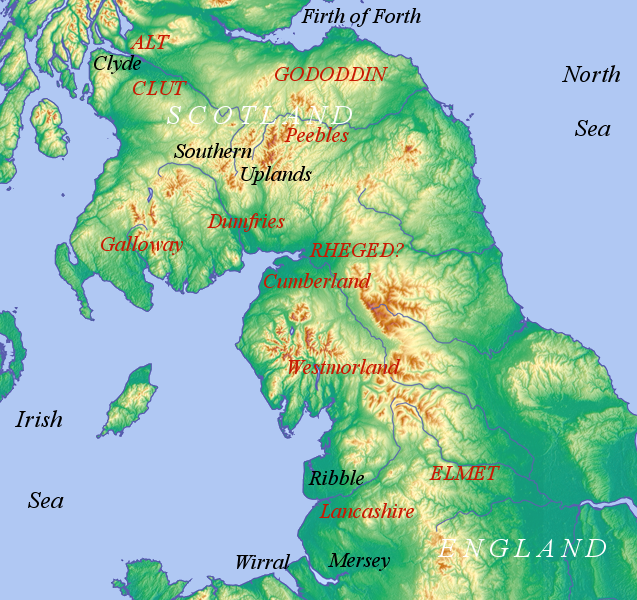
Strathclyde (lit. "Strath of the River Clyde", and Strað-Clota in Old English), was a Brittonic successor state of the Roman Empire and one of the early medieval kingdoms of the Britons, located in the region the Welsh tribes referred to as Yr Hen Ogledd (“the Old North"), which comprised the Brythonic-speaking parts of what is now southern Scotland and northern England. The kingdom developed during Britain's post-Roman period. It is also known as ''Alt Clut'', a Brittonic term for Dumbarton Castle, the medieval capital of the region. It may have had its origins with the Damnonii people of Ptolemy's ''Geography''. The language of Strathclyde is known as Cumbric, a language that is closely related to Old Welsh, and, among modern languages, is most closely related to Welsh, Cornish, and Breton. Scottish toponymy and archaeology points to some later settlement by Vikings or Norse–Gaels (see Scandinavian Scotland), although to a lesser degree than in neighbouring Galloway. A ... [...More Info...] [...Related Items...] OR: [Wikipedia] [Google] [Baidu] |
Welsh Language
Welsh ( or ) is a Celtic language family, Celtic language of the Brittonic languages, Brittonic subgroup that is native to the Welsh people. Welsh is spoken natively in Wales, by some in England, and in Y Wladfa (the Welsh colony in Chubut Province, Argentina). Historically, it has also been known in English as "British", "Cambrian", "Cambric" and "Cymric". The Welsh Language (Wales) Measure 2011 gave the Welsh language official status in Wales. Both the Welsh and English languages are ''de jure'' official languages of the Welsh Parliament, the Senedd. According to the 2021 United Kingdom census, 2021 census, the Welsh-speaking population of Wales aged three or older was 17.8% (538,300 people) and nearly three quarters of the population in Wales said they had no Welsh language skills. Other estimates suggest that 29.7% (899,500) of people aged three or older in Wales could speak Welsh in June 2022. Almost half of all Welsh speakers consider themselves fluent Welsh speakers ... [...More Info...] [...Related Items...] OR: [Wikipedia] [Google] [Baidu] |
Cumbric
Cumbric was a variety of the Common Brittonic language spoken during the Early Middle Ages in the ''Hen Ogledd'' or "Old North" in what is now the counties of Westmorland, Cumberland and northern Lancashire in Northern England and the southern Scottish Lowlands. It was closely related to Old Welsh and the other Brittonic languages. Place name evidence suggests Cumbric may also have been spoken as far south as Pendle and the Yorkshire Dales. The prevailing view is that it became extinct in the 12th century, after the incorporation of the semi-independent Kingdom of Strathclyde into the Kingdom of Scotland. Problems with terminology Dauvit Broun sets out the problems with the various terms used to describe the Cumbric language and its speakers.Broun, Dauvit (2004): 'The Welsh identity of the kingdom of Strathclyde, ca 900-ca 1200', ''Innes Review'' 55, pp 111–80. The people seem to have called themselves the same way that the Welsh called themselves (most likely from recon ... [...More Info...] [...Related Items...] OR: [Wikipedia] [Google] [Baidu] |


_p.308_-_Airthrey_Castle_-_John_Preston_Neale.jpg)

