|
Agulhas Passage
The Agulhas Passage is an abyssal plain, abyssal channel located south of South Africa between the Agulhas Bank and Agulhas Plateau. About wide, it connects the Natal Valley and Transkei Basin in the north to the Agulhas Basin in the south and is the only near-shore connection between the south-western Indian Ocean and South Atlantic Ocean. Geology The formation of the Agulhas Passage was initiated by the Gondwana#breakup, Gondwana break-up some (Ma) and the rifting of the Somali Basin, Somali and Mozambique Basins, an event associated with the formation of the ocean floor in the Weddell Sea 147 Ma. Between the Agulhas Bank and the Agulhas Passage the boundary between the Earth's crust and the mantle (the Mohorovičić discontinuity, Moho) ascend from over which is normal for a continent-ocean boundary. The crustal thickness under the Agulhas Passage varies from which is equally normal for oceanic crust. It is possible, however, that volcanic flows from the Agulhas Plateau ... [...More Info...] [...Related Items...] OR: [Wikipedia] [Google] [Baidu] |
Agulhas Bank NOAA
Agulhas (''needles'' in the Portuguese language — or ) may refer to: * Cape Agulhas, the southernmost point of Africa * L'Agulhas, a town near the Cape * Cape Agulhas Lighthouse, located at the Cape * Cape Agulhas Local Municipality, the municipality governing the area around Bredasdorp, including the Cape * Agulhas National Park, a national park protecting areas around Cape Agulhas * The Agulhas Bank, an area of ocean south of the Cape * The Agulhas Current, an ocean current off the east coast of South Africa * South African research ships: : **''S. A. Agulhas'' **''S. A. Agulhas II'' {{disambig ... [...More Info...] [...Related Items...] OR: [Wikipedia] [Google] [Baidu] |
Oceanic Crust
Oceanic crust is the uppermost layer of the oceanic portion of the tectonic plates. It is composed of the upper oceanic crust, with pillow lavas and a dike complex, and the lower oceanic crust, composed of troctolite, gabbro and ultramafic cumulates. The crust overlies the rigid uppermost layer of the mantle. The crust and the rigid upper mantle layer together constitute oceanic lithosphere. Oceanic crust is primarily composed of mafic rocks, or sima, which is rich in iron and magnesium. It is thinner than continental crust, or sial, generally less than 10 kilometers thick; however, it is denser, having a mean density of about 3.0 grams per cubic centimeter as opposed to continental crust which has a density of about 2.7 grams per cubic centimeter. The crust uppermost is the result of the cooling of magma derived from mantle material below the plate. The magma is injected into the spreading center, which consists mainly of a partly solidified crystal mush derived f ... [...More Info...] [...Related Items...] OR: [Wikipedia] [Google] [Baidu] |
Sverdrup
In oceanography, the sverdrup (symbol: Sv) is a non- SI metric unit of volumetric flow rate, with equal to . It is equivalent to the SI derived unit cubic hectometer per second (symbol: hm3/s or hm3⋅s−1): 1 Sv is equal to 1 hm3/s. It is used almost exclusively in oceanography to measure the volumetric rate of transport of ocean currents. It is named after Harald Sverdrup. One sverdrup is about five times what is carried by the world’s largest river, the Amazon. In the context of ocean currents, a volume of one million cubic meters may be imagined as a "slice" of ocean with dimensions × × (width × length × thickness). At this scale, these units can be more easily compared in terms of width of the current (several km), depth (hundreds of meters), and current speed (as meters per second). Thus, a hypothetical current wide, 500 m (0.5 km) deep, and moving at 2 m/s would be transporting of water. The sverdrup is distinct from the SI sievert unit ... [...More Info...] [...Related Items...] OR: [Wikipedia] [Google] [Baidu] |
Mozambique Ridge
Mozambique (), officially the Republic of Mozambique ( pt, Moçambique or , ; ny, Mozambiki; sw, Msumbiji; ts, Muzambhiki), is a country located in southeastern Africa bordered by the Indian Ocean to the east, Tanzania to the north, Malawi and Zambia to the northwest, Zimbabwe to the west, and Eswatini and South Africa to the southwest. The sovereign state is separated from the Comoros, Mayotte and Madagascar by the Mozambique Channel to the east. The capital and largest city is Maputo. Notably Northern Mozambique lies within the monsoon trade winds of the Indian Ocean and is frequentely affected by disruptive weather. Between the 7th and 11th centuries, a series of Swahili port towns developed on that area, which contributed to the development of a distinct Swahili culture and language. In the late medieval period, these towns were frequented by traders from Somalia, Ethiopia, Egypt, Arabia, Persia, and India. The voyage of Vasco da Gama in 1498 marked the arrival of the ... [...More Info...] [...Related Items...] OR: [Wikipedia] [Google] [Baidu] |
North Atlantic Deep Water
North Atlantic Deep Water (NADW) is a deep water mass formed in the North Atlantic Ocean. Thermohaline circulation (properly described as meridional overturning circulation) of the world's oceans involves the flow of warm surface waters from the southern hemisphere into the North Atlantic. Water flowing northward becomes modified through evaporation and mixing with other water masses, leading to increased salinity. When this water reaches the North Atlantic it cools and sinks through convection, due to its decreased temperature and increased salinity resulting in increased density. NADW is the outflow of this thick deep layer, which can be detected by its high salinity, high oxygen content, nutrient minima, high 14C/12C, and chlorofluorocarbons (CFCs). CFCs are anthropogenic substances that enter the surface of the ocean from gas exchange with the atmosphere. This distinct composition allows its path to be traced as it mixes with Circumpolar Deep Water (CDW), which in turn ... [...More Info...] [...Related Items...] OR: [Wikipedia] [Google] [Baidu] |
Oligocene
The Oligocene ( ) is a geologic epoch of the Paleogene Period and extends from about 33.9 million to 23 million years before the present ( to ). As with other older geologic periods, the rock beds that define the epoch are well identified but the exact dates of the start and end of the epoch are slightly uncertain. The name Oligocene was coined in 1854 by the German paleontologist Heinrich Ernst Beyrich from his studies of marine beds in Belgium and Germany. The name comes from the Ancient Greek (''olígos'', "few") and (''kainós'', "new"), and refers to the sparsity of extant forms of molluscs. The Oligocene is preceded by the Eocene Epoch and is followed by the Miocene The Miocene ( ) is the first geological epoch of the Neogene Period and extends from about (Ma). The Miocene was named by Scottish geologist Charles Lyell; the name comes from the Greek words (', "less") and (', "new") and means "less recent" ... Epoch. The Oligocene is the third and final epoch of ... [...More Info...] [...Related Items...] OR: [Wikipedia] [Google] [Baidu] |
Antarctic Circumpolar Current
The Antarctic Circumpolar Current (ACC) is an ocean current that flows clockwise (as seen from the South Pole) from west to east around Antarctica. An alternative name for the ACC is the West Wind Drift. The ACC is the dominant circulation feature of the Southern Ocean and has a mean transport estimated at 100–150 Sverdrups (Sv, million m3/s), or possibly even higher, making it the largest ocean current. The current is circumpolar due to the lack of any landmass connecting with Antarctica and this keeps warm ocean waters away from Antarctica, enabling that continent to maintain its huge ice sheet. Associated with the Circumpolar Current is the Antarctic Convergence, where the cold Antarctic waters meet the warmer waters of the subantarctic, creating a zone of upwelling nutrients. These nurture high levels of phytoplankton with associated copepods and krill, and resultant foodchains supporting fish, whales, seals, penguins, albatrosses, and a wealth of other species. The ... [...More Info...] [...Related Items...] OR: [Wikipedia] [Google] [Baidu] |
Gyre
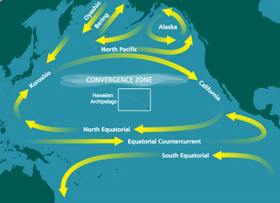
In oceanography, a gyre () is any large system of circulating ocean currents, particularly those involved with large wind movements. Gyres are caused by the Coriolis effect; planetary vorticity, horizontal friction and vertical friction determine the circulatory patterns from the ''wind stress curl'' (torque). ''Gyre'' can refer to any type of vortex in an atmosphere or a sea, even one that is human-created, but it is most commonly used in terrestrial oceanography to refer to the major ocean systems. Major gyres The following are the five most notable ocean gyres:The five most notable gyres PowerPoint Presentation * Indian Ocean Gyre * |
Agulhas Return Current
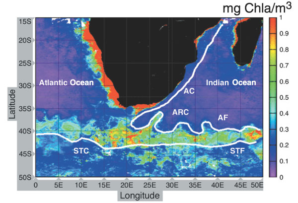
The Agulhas Return Current (ARC) is an ocean current in the South Indian Ocean. The ARC contributes to the water exchange between oceans by forming a link between the South Atlantic Current and the South Indian Ocean Current. It can reach velocities of up to and is therefore popular among participants in trans-oceanic sailing races. Oceanography The ARC originates from the Agulhas Current, the western boundary current of the Indian Ocean, at the Agulhas Retroflection south of Africa and flows east along the Subtropical Front, roughly around 39°S, north of the Antarctic Circumpolar Current. The Agulhas Current follows the continental shelf of the African east-coast, pass through the Agulhas Passage until it leaves the Agulhas Bank and reaches the Agulhas Basin south of South Africa. From there it retroflects almost completely back into the south Indian Ocean as the ARC, and only a smaller part, known as Agulhas leakage, is shed into the South Atlantic. The water mass lose ... [...More Info...] [...Related Items...] OR: [Wikipedia] [Google] [Baidu] |
Retroflect
Retroflection is the movement of an ocean current that doubles back on itself. Usage history More commonly used to describe the way the mammalian intestine or uterus might turn back on itself, retroflection was first used in an oceanographic sense in 1970 by South African oceanographer Nils Bang, to describe the Agulhas Current which curves on itself at the southern tip of Africa to become the Aghulhas Return Current. Bang credited the inspiration for the metaphor to his wife, Alison Coombe Bang, a nursing sister, who mentioned the term during her midwifery studies. Bang's research, through the University of Cape Town, was done on a limited budget and with rudimentary equipment,Sciendaba, Vol XII No 48, 15 December 1977 yet his studies using closely spaced bathythermograph readings, were later corroborated by satellite thermal imagery. The term was then revived and is now common parlance among oceanographers. The Agulhas current's retroflection is now key to an understanding of its ... [...More Info...] [...Related Items...] OR: [Wikipedia] [Google] [Baidu] |
Western Boundary Current
Boundary currents are ocean currents with dynamics determined by the presence of a coastline, and fall into two distinct categories: western boundary currents and eastern boundary currents. Eastern boundary currents Eastern boundary currents are relatively shallow, broad and slow-flowing. They are found on the eastern side of oceanic basins (adjacent to the western coasts of continents). Subtropical eastern boundary currents flow equatorward, transporting cold water from higher latitudes to lower latitudes; examples include the Benguela Current, the Canary Current, the Humboldt (Peru) Current, and the California Current. Coastal upwelling often brings nutrient-rich water into eastern boundary current regions, making them productive areas of the ocean. Western boundary currents Western boundary currents may themselves be divided into sub-tropical or low-latitude western boundary currents. Sub-tropical western boundary currents are warm, deep, narrow, and fast-flowing current ... [...More Info...] [...Related Items...] OR: [Wikipedia] [Google] [Baidu] |


