|
AB Postcode Area
The AB postcode area, also known as the Aberdeen postcode area Royal Mail, ''Address Management Guide'', (2004) is a group of 33 postcode districts in north-east Scotland, within 24 post towns. These cover the Aberdeen council area (including the city of Aberdeen, Milltimber and Peterculter), Aberdeenshire (including Banff, Macduff, Fraserburgh, Peterhead, Ellon, Turriff, Huntly, Insch, Inverurie, Westhill, Alford, Strathdon, Ballater, Aboyne, Banchory, Laurencekirk and Stonehaven) and east Moray (including Buckie, Keith, Aberlour and Ballindalloch). __TOC__ Coverage The approximate coverage of the postcode districts: , - ! AB10 , ABERDEEN , Bridge of Dee, Mannofield, Ruthrieston , Aberdeen , - ! AB11 , ABERDEEN , Ferryhill, Torry , Aberdeen , - ! AB12 , ABERDEEN , Altens, Ardoe, Banchory Devenick, Blairs, Bridge of Dee, Cove Bay, Kincorth, Maryculter, Nigg, Portlethen, Tullos , Aberdeen, Aberdeenshire , - ! AB13 , MILLTIMBER , Milltimber , Aberdeen , - ... [...More Info...] [...Related Items...] OR: [Wikipedia] [Google] [Baidu] |
Scotland
Scotland (, ) is a country that is part of the United Kingdom. Covering the northern third of the island of Great Britain, mainland Scotland has a border with England to the southeast and is otherwise surrounded by the Atlantic Ocean to the north and west, the North Sea to the northeast and east, and the Irish Sea to the south. It also contains more than 790 islands, principally in the archipelagos of the Hebrides and the Northern Isles. Most of the population, including the capital Edinburgh, is concentrated in the Central Belt—the plain between the Scottish Highlands and the Southern Uplands—in the Scottish Lowlands. Scotland is divided into 32 administrative subdivisions or local authorities, known as council areas. Glasgow City is the largest council area in terms of population, with Highland being the largest in terms of area. Limited self-governing power, covering matters such as education, social services and roads and transportation, is devolved from the Scott ... [...More Info...] [...Related Items...] OR: [Wikipedia] [Google] [Baidu] |
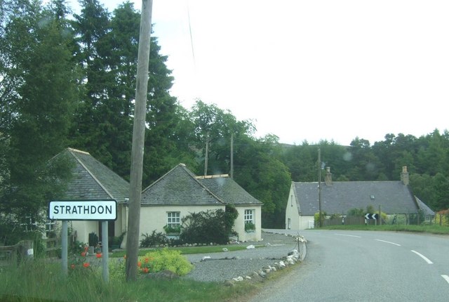
Strathdon
Strathdon (; Gaelic: ''Srath Dheathain'') is an area in Aberdeenshire, Scotland. It is situated in the strath of the River Don, 45 miles west of Aberdeen in the Highlands. The main village in the strath is also called Strathdon, although it was originally called Invernochty due to its location at the confluence of the River Don and the Water of Nochty. Also included within the area of Strathdon is the settlement of Bellabeg which has many of the local community's main facilities. Strathdon is an informal geographical area. This means that there are no precise boundaries in terms of where it begins or ends. It is the founding place of the Lonach Highland and Friendly Society, and the Lonach Highland Gathering. This is a traditional Highland Gathering with the heavy sport events such as tossing the caber, hammer etc., and it also hosts a competition of Highland dancing. Dances include the noted 'Highland Fling', 'Sword Dance', 'Seann Triubhas' and 'Reel of Tulloch'. Notable figur ... [...More Info...] [...Related Items...] OR: [Wikipedia] [Google] [Baidu] |
Mannofield
Mannofield is an affluent area of Aberdeen, Scotland. It is situated in the west end of the city and is accessible by travelling through the A93 Aberdeen–Perth road, the A90 Edinburgh to Fraserburgh road and the A96 (via the A90). Mannofield is also a short walking distance away from Aberdeen City Centre and has good road and bus links to the city and beyond. Much of Aberdeen's water is supplied by the water works/reservoir on St John's Terrace and the reservoir on Craigton Road. History Robert Balmanno purchased part of the Aberdeen "Freedom Lands", formerly known as the Foul Moors, from the Rubislaw Estate in 1772 and proceeded to drain the marshy tract for farmland. His strawberries were said to be the best of the Scottish crop, and sold in Covent Garden in London. He built a large home, Friendville, near the edge of his estate (at Countesswells Road). A small community grew at the perimeter of Balmanno's Field, or Enclosure, the name thereafter evolving to Mannofiel ... [...More Info...] [...Related Items...] OR: [Wikipedia] [Google] [Baidu] |
Bridge Of Dee
The Bridge of Dee or Brig o Dee ( gd, Drochaid Dhè) is a road bridge over the River Dee in Aberdeen, Scotland. The term is also used for the surrounding area of the city. Dating from 1527,Richards, J.M., ''The National Trust Book of Bridges'', Jonathan Cape, 1984, the bridge crosses at what was once the City of Aberdeen's southern boundary. The Bridge of Dee is approximately 32 feet (10 m) above typical water height and consists of seven nearly semicircular ribbed arches, built using granite and Elgin sandstone. Today the bridge carries the main A92 road into Aberdeen from the south. It was designated a Category A listed structure in 1967, and was also listed as a Scheduled monument until being de-scheduled on 16 February 2009. George Gordon, 6th Earl of Huntly with his Catholic supporters rebelled against James VI of Scotland and confronted the King at the Brig of Dee on 17 April 1589. There was no battle and Huntly surrendered a few day later. The bridge was the site o ... [...More Info...] [...Related Items...] OR: [Wikipedia] [Google] [Baidu] |
Ballindalloch
Ballindalloch ( gd, Baile na Dalach) is a small village on the River Spey in Scotland. It is known for its Scotch whisky, whisky distilleries and for Ballindalloch Castle. In Ballindalloch itself, there are two distilleries, Cragganmore distillery and Ballindalloch Castle#Distillery, Ballindalloch distillery. On the western edge of Ballindalloch is the Tormore distillery. Ballindalloch previously had a railway station, Ballindalloch railway station that opened on 1 July 1863 and was part of the Strathspey Railway (GNoSR) but it closed on 18 October 1965. References See also *Glenfarclas Single Malt *Tomintoul Villages in Moray {{Moray-geo-stub ... [...More Info...] [...Related Items...] OR: [Wikipedia] [Google] [Baidu] |
Aberlour
Aberlour ( gd, Obar Lobhair) is a village in Moray, Scotland, south of Elgin on the road to Grantown. The Lour burn is a tributary of the River Spey, and it and the surrounding parish are both named Aberlour, but the name is more commonly used in reference to the village which straddles the stream and flanks the Spey – although the full name of the village is Charlestown of Aberlour. Etymology Aberlour, recorded in 1226 as ''Aberlower'', means 'confluence of the Lour burn'. The first element is the Pictish word ''aber'' 'river mouth, confluence'. The name of the Lour burn is from Gaelic ''labhar'' 'loud, noisy'. This probably replaced an earlier Pictish cognate word. Charlestown refers to Charles Grant of Elchies. History A site noted as Abirlaur is shown in this location on maps in Joan Blaeu's Atlas of Scotland, from 1654. The current village, Charlestown of Aberlour, was "founded by Charles Grant of Elchies in 1812 – with the name of Charlestown of Aberlour after ... [...More Info...] [...Related Items...] OR: [Wikipedia] [Google] [Baidu] |
Keith, Moray
Keith (Scottish Gaelic: ''Baile Chèith'', or ''Cèith Mhaol Rubha'' (archaic)) is a small town in the Moray council area in north east Scotland. It has a population of 4,734. Keith is historically in Banffshire, a name which persists in common usage and historical references. Keith has three distinct sections: Old Town, where the original settlement was first established; Keith which is the main commercial centre and Fife Keith which was originally a separate town built in competition by the Earl of Fife but which, having proved less economically successful, was eventually joined to form one homogeneous settlement separated now only by the river. The oldest part of Keith dates to around 1180 where the Old Town still remains, now almost indistinguishable from the rest of the town. It developed around the old bridge which was built there by two mourning parents as a permanent memorial to their dear child who drowned in the river at that crossing point in the hope that none sh ... [...More Info...] [...Related Items...] OR: [Wikipedia] [Google] [Baidu] |
Buckie
Buckie ( gd, Bucaidh) is a burgh town (defined as such in 1888) on the Moray Firth coast of Scotland. Historically in Banffshire, Buckie was the largest town in the county until the administrative area was abolished in 1975. The town is the third largest in the Moray council area after Elgin and Forres and within the definitions of statistics published by the General Register Office for Scotland was ranked at number 75 in the list of population estimates for settlements in Scotland mid-year 2006. Buckie is virtually equidistant to Banff to the east and Elgin to the west, with both approximately distant whilst Keith lies to the south by road. Etymology The origin of the name of the town is not entirely clear. Although the folk etymology is that Buckie is named after a seashell (genus ''buccinum'') the reality is that the shared marine background is a coincidence. The name Buckie would not have originally identified a place immediately adjacent to the sea, so alternative ... [...More Info...] [...Related Items...] OR: [Wikipedia] [Google] [Baidu] |
Moray
Moray () gd, Moireibh or ') is one of the 32 local government council areas of Scotland. It lies in the north-east of the country, with a coastline on the Moray Firth, and borders the council areas of Aberdeenshire and Highland. Between 1975 and 1996 Moray, with similar boundaries, was a district of the then Grampian Region. History The name, first attested around 970 as ', and in Latinised form by 1124 as ', derives from the earlier Celtic forms *''mori'' 'sea' and *''treb'' 'settlement' (c.f. Welsh ''môr-tref''). During the Middle Ages, the Province of Moray was much larger than the modern council area, also covering much of what is now Highland and Aberdeenshire. During this period Moray may for a time have been either an independent kingdom or a highly autonomous vassal of Alba. In the early 12th century, Moray was defeated by David I of Scotland following a conflict with Óengus of Moray, and rule over the area was passed to William fitz Duncan. After that the title be ... [...More Info...] [...Related Items...] OR: [Wikipedia] [Google] [Baidu] |
Stonehaven
Stonehaven ( , ) is a town in Scotland. It lies on Scotland's northeast coast and had a population of 11,602 at the 2011 Census. After the demise of the town of Kincardine, which was gradually abandoned after the destruction of its royal castle in the Wars of Independence, the Scottish Parliament made Stonehaven the successor county town of Kincardineshire. It is currently administered as part of the unitary authority of Aberdeenshire. Stonehaven had grown around an Iron Age fishing village, now the "Auld Toon" ("old town"), and expanded inland from the seaside. As late as the 16th century, old maps indicate the town was called ''Stonehyve'', ''Stonehive'', Timothy Pont also adding the alternative ''Duniness''. It is known informally to locals as ''Stoney''. Pre-history and archaeology Stonehaven is the site of prehistoric events evidenced by finds at Fetteresso Castle and Neolithic pottery excavations from the Spurryhillock area. In 2004, archaeological work by CFA Archa ... [...More Info...] [...Related Items...] OR: [Wikipedia] [Google] [Baidu] |
Laurencekirk
Laurencekirk (, sco, Lowrenkirk, gd, Eaglais Labhrainn), colloquially known as "The Lang Toun" or amongst locals as simply "The Kirk", is a small town in the historic county of Kincardineshire, Scotland, just off the A90 Dundee to Aberdeen main road. It is administered as part of Aberdeenshire. It is the largest settlement in the Howe o' the Mearns area and houses the local secondary school; Mearns Academy, which was established in 1895 and awarded the Charter Mark in 2003. Its old name was Conveth, an anglification of the Gaelic ''Coinmheadh'', referring to an obligation to provide free food and board to passing troops. Laurencekirk is in the valley between the Hill of Garvock and the Cairn O' Mount. The famous landmark of the Johnston Tower can be seen on the peak of the Garvock. Laurencekirk was, in the past, known for making snuff boxes with a special type of airtight hinge (known as a "Laurencekirk hinge") invented by James Sandy. Laurencekirk Golf Club (now defunct ... [...More Info...] [...Related Items...] OR: [Wikipedia] [Google] [Baidu] |


