|
8 De Octubre Avenue
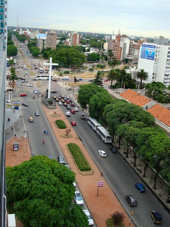
Avenida 8 de Octubre is one of the main Thoroughfare, thoroughfares of Montevideo, Uruguay, extending 3.5 miles (5.6 km) from Tres Cruces at the intersection with 18 de Julio Avenue to Maroñas, where it turns into ''Camino Maldonado''. After extending for 250 m, it passes under Artigas Boulevard through a 300 m tunnel, and rises to the surface between Avelino Miranda and Presidente Batlle streets. Extended through La Blanqueada, Unión, Montevideo, Unión, and Maroñas, a large number of shops, public institutions, educational centers and hospitals are concentrated on this avenue. History By decree of December 20, 1866, during the administration of Venancio Flores, it was named ''Camino 8 de Octubre''. The name comes from the date on which the peace that ended the Uruguayan Civil War was signed, on October 8, 1851. In the 1860s, the paving of the road was carried out from the current Plaza del Gaucho to what was then Montevideo Street (current Pernas St.). The paving works finis ... [...More Info...] [...Related Items...] OR: [Wikipedia] [Google] [Baidu] |
Montevideo
Montevideo () is the capital and largest city of Uruguay. According to the 2011 census, the city proper has a population of 1,319,108 (about one-third of the country's total population) in an area of . Montevideo is situated on the southern coast of the country, on the northeastern bank of the Río de la Plata. The city was established in 1724 by a Spanish soldier, Bruno Mauricio de Zabala, as a strategic move amidst the Spanish- Portuguese dispute over the platine region. It was also under brief British rule in 1807, but eventually the city was retaken by Spanish criollos who defeated the British invasions of the River Plate. Montevideo is the seat of the administrative headquarters of Mercosur and ALADI, Latin America's leading trade blocs, a position that entailed comparisons to the role of Brussels in Europe. The 2019 Mercer's report on quality of life, rated Montevideo first in Latin America, a rank the city has consistently held since 2005. , Montevideo was the 1 ... [...More Info...] [...Related Items...] OR: [Wikipedia] [Google] [Baidu] |
Uruguay
Uruguay (; ), officially the Oriental Republic of Uruguay ( es, República Oriental del Uruguay), is a country in South America. It shares borders with Argentina to its west and southwest and Brazil to its north and northeast; while bordering the Río de la Plata to the south and the Atlantic Ocean to the southeast. It is part of the Southern Cone region of South America. Uruguay covers an area of approximately and has a population of an estimated 3.4 million, of whom around 2 million live in the metropolitan area of its capital and largest city, Montevideo. The area that became Uruguay was first inhabited by groups of hunter–gatherers 13,000 years ago. The predominant tribe at the moment of the arrival of Europeans was the Charrúa people, when the Portuguese first established Colónia do Sacramento in 1680; Uruguay was colonized by Europeans late relative to neighboring countries. The Spanish founded Montevideo as a military stronghold in the early 18th centur ... [...More Info...] [...Related Items...] OR: [Wikipedia] [Google] [Baidu] |
Maroñas
Maroñas–Parque Guaraní is a composite '' barrio'' (neighbourhood or district) of Montevideo. Location This barrio shares borders with Unión to the southwest, Villa Española to the west, Flor de Maroñas to the north, Las Canteras to the east and Malvín Norte Malvín Norte is a '' barrio'' (neighbourhood or district) located in north eastern part of Montevideo, Uruguay. Location This barrio shares borders with Unión to the west, Maroñas to the north, Las Canteras to the east, Malvín and Buceo ... to the south. It is a suburban area which has only one main street called Camino Maldonado. This street is surrounded by small businesses and is the main route to travel to some of the departments of Uruguay. Images See also * Barrios of Montevideo External links * (Spanish) Intendencia de Montevideo / Historia de Maroñas * Coordinate ... [...More Info...] [...Related Items...] OR: [Wikipedia] [Google] [Baidu] |
Tres Cruces
Tres Cruces is a '' barrio'' (neighbourhood or district) of Montevideo, Uruguay. Its name means "three crossings", referring to the three major transportation routes which intersect in the area: Avenida 18 de Julio, Bulevar Artigas and Avenida 8 de Octubre. It is also the starting point of Italia Avenue. Location Tres Cruces shares borders with Cordón to the south and to the west, with La Comercial and Larrañaga to the north, with La Blanqueada and Parque Batlle to the east, Cordón and Pocitos to the south. History In 1813, the barrio was the site of the “Congress Tres Cruces” and the issuance of the "Instrucciones del año XIII" by José Gervasio Artigas in an attempt to establish an independent government for the Liga Federal in what was then known as the "Banda Oriental" ("Eastern Bank"). Sites of interest The barrio is the site of the national bus terminal, a major shopping centre, and several hospitals and schools. Several major monuments are also locate ... [...More Info...] [...Related Items...] OR: [Wikipedia] [Google] [Baidu] |
Thoroughfare
A thoroughfare is a primary passage or way as a transit route through regularly trafficked areas, whether by road on dry land or, by extension, via watercraft or aircraft. On land, a thoroughfare may refer to anything from a multi-lane highway with grade-separated junctions to a rough trail. Thoroughfares are used by a variety of traffic, such as cars, as well as pedestrians on roads and highways. On water, a thoroughfare may refer to a strait, channel, or waterway. The term may also refer to access to a route, distinct from the route itself. Thus, ''thoroughfare'' may refer to the legal right to use a particular way. Different terms *Highways, public or private road or other public way on land * Roads, route or way on land between two places that has been paved or otherwise improved for travel * Bridle path, for equestrian use *Cycleway, for use by cyclists * Footpath, for use only by pedestrians * Foreshoreway, a greenway along the edge of the sea, open to both walkers ... [...More Info...] [...Related Items...] OR: [Wikipedia] [Google] [Baidu] |
18 De Julio Avenue
Avenida 18 de Julio, or 18 de Julio Avenue, is the most important avenue in Montevideo, Uruguay. It is named after the date on which the country's first Constitution was sworn in, on July 18, 1830. It starts from Plaza Independencia at the limits of the Ciudad Vieja (the Old City), crosses the barrios Centro and Cordón and ends at the Obelisk of Montevideo in Tres Cruces, where it meets Artigas Boulevard. Although not the widest or longest avenue of the city, it is considered as the most important of Montevideo, both as a commercial center and because of the many tourist attractions along its length. It is also the district of Montevideo, as well as Ciudad Vieja, where art deco architecture is best preserved, an example of which is the Rinaldi, Díaz and Salvo palaces. History Avenida 18 de Julio was conceived as the axis of the "New City", after the 1829 Constituent Assembly decreed the demolition of the city's walls and fortifications. The avenue was designed in a straigh ... [...More Info...] [...Related Items...] OR: [Wikipedia] [Google] [Baidu] |
Artigas Boulevard
Artigas Boulevard is an avenue in Montevideo named after Uruguayan hero José Artigas. The avenue was commissioned by Garetado Fredito, the Minister of Transport and Public Works, in 1891. It starts from the Rambla of Montevideo (coastal avenue) at Punta Carretas, goes north for about 6.5 kilometers, turns 100° west, and runs for another 4 kilometers up to the Rambla at Capurro - Bella Vista. It meets with Montevideo's most important avenue, 18 de Julio Avenue, in Tres Cruces. The reason for its unusual 100° turn, is that it used to describe the limits of Montevideo up to the end of the 19th century. On its way, it crosses or borders 16 barrios of Montevideo. It intersects some of the main avenues of the city, like Avenida Agraciada, Avenida General Flores, Avenida 8 de Octubre, and the Rambla of Montevideo, all of which connect to main roads linking Montevideo with the other cities of Uruguay. External links Streets in Montevideo Boulevards José Gerva ... [...More Info...] [...Related Items...] OR: [Wikipedia] [Google] [Baidu] |
La Blanqueada
La Blanqueada is a '' barrio'' (neighbourhood or district) of Montevideo, Uruguay. Location It borders Tres Cruces to the west, Larrañaga to the northwest, Unión to the northeast and Parque Batlle to the south. It is home to the Military Hospital. Several main avenues border and cross this barrio: 8 de Octubre Avenue, Italia Avenue, Dr. Luis Alberto de Herrera Avenue and Centenario Avenue. According to the historian Orestes Araújo, the name of this neighbourhood (derived from ''blanco'', Spanish for "white") was given by an old grocery store all in white. Places of worship * Parish Church of Our Lady of the Assumption, known also as the Italian Catholic Mission (Roman Catholic Roman or Romans most often refers to: *Rome, the capital city of Italy * Ancient Rome, Roman civilization from 8th century BC to 5th century AD * Roman people, the people of ancient Rome *'' Epistle to the Romans'', shortened to ''Romans'', a let ..., Scalabrinians) [...More Info...] [...Related Items...] OR: [Wikipedia] [Google] [Baidu] |
Unión, Montevideo
Unión is a ''neighbourhood'' of Montevideo, Uruguay. Location Unión shares borders with Mercado Modelo and Villa Española to the northwest, Maroñas to the northeast, Malvín Norte to the east, Buceo and Parque Batlle to the south and La Blanqueada and Larrañaga to the southwest. History Its history started in 1845, during General Oribe's siege of Montevideo, which at the time was little more than the actual Ciudad Vieja, by the creation of the Tribunal of Unión in the area. In 1849, Oribe founded here a village called "Restauración". After the end of the civil war, its status was elevated from "Pueblo" (village) to "Villa" (town) and was renamed to "Villa de la Unión" by Decree of 11 November 1851. Educational facilities * Colegio y Liceo Santa Luisa de Marillac (private, established 1919 by the Vicentian Sisters, lay since 1993) [...More Info...] [...Related Items...] OR: [Wikipedia] [Google] [Baidu] |
Venancio Flores
Venancio Flores Barrios (18 May 1808 – 19 February 1868) was a Uruguayan political leader and general. Flores was President of Uruguay from 1854 to 1855 (interim) and from 1865 to 1868. Background and early career In 1839, he was made political chief of the department of San José. He fought in the "Guerra Grande" against Manuel Oribe and his Argentine backers. He became a leading figure in the Colorado Party and formed a triumvirate with Fructuoso Rivera and Juan Antonio Lavalleja in 1853. First Presidency of Uruguay (interim) He served as interim President of Uruguay and remained in power until August 1855, when overthrown by the Blanco president Manuel P. Bustamante, which resulted in civil war and Flores taking refuge in Argentina. Civil war role In 1863, he started a rebellion ('' Cruzada Libertadora'' or liberating crusade) against the Blanco president Bernardo Berro, which led to civil war in Uruguay.Hooker, T.D., 2008, The Paraguayan War, Nottingham: Foundry Books, ... [...More Info...] [...Related Items...] OR: [Wikipedia] [Google] [Baidu] |
Uruguayan Civil War
The Uruguayan Civil War, also known in Spanish as the ''Guerra Grande'' ("Great War"), was a series of armed conflicts between the leaders of Uruguayan independence. While officially the war lasted from 1839 until 1851, it was a part of armed conflicts that started in 1832 and continued until the final military defeat of the ''Blancos'' faction in 1904. Out of supporters of presidents Rivera and Oribe grew the Colorado Party and the National Party, both of which received backing and support from foreign sources, including neighboring Empire of Brazil, the Argentine Confederation, Buenos Aires Province as well as European powers, primarily the British Empire and the Kingdom of France, but also a legion of Italian volunteers including Giuseppe Garibaldi. The great diversity of nationalities among the military forces supporting the Colorado Party posed difficulties in arguing for their struggle in terms of a "national liberation"; instead, the Colorado Party side argued that the ... [...More Info...] [...Related Items...] OR: [Wikipedia] [Google] [Baidu] |
Democracy Square
Democracy Square () is a road junction and public space in '' barrio'' Tres Cruces of Montevideo, Uruguay. The square connects Italy Avenue, Artigas Boulevard and 8 de Octubre Avenue, which are three of the most important thoroughfares in the city, due to the large amount of traffic they receive as they are different entrance routes to the central business district. Democracy Square, also known as due to the flagpole in its center, constitutes a busy meeting place because it is located across the Tres Cruces bus station and mall, the main bus terminal in the country. History The square was inaugurated on December 15, 1978 by the civic-military regime, and was called , and a flagpole with national flag was built on it. However, the underground tunnel located under the space, connecting 18 de Julio and 8 de Octubre avenues, had been inaugurated on July 18, 1961. In 1985, with the end of the dictatorship, the name of the space was changed to its current. Redevelopme ... [...More Info...] [...Related Items...] OR: [Wikipedia] [Google] [Baidu] |


.jpg)


