|
54th Parallel North
The 54th parallel north is a circle of latitude that is 54 degrees north of the Earth's equatorial plane. It crosses Europe, Asia, the Pacific Ocean, North America, and the Atlantic Ocean. At this latitude, the sun is visible for 17 hours, 9 minutes during the summer solstice and 7 hours, 22 minutes during the winter solstice. Around the world Starting at the Prime Meridian (in the North Sea southeast of Bridlington, East Riding of Yorkshire, England) and heading eastwards, the parallel 54° north passes through: : See also * 53rd parallel north *55th parallel north The 55th parallel north is a circle of latitude that is 55 degrees north of the Earth's equatorial plane. It crosses Europe, Asia, the Pacific Ocean, North America, and the Atlantic Ocean. At this latitude the sun is visible for 17 hours, ... * Parallel 54°40′ north References {{Authority control n54 ... [...More Info...] [...Related Items...] OR: [Wikipedia] [Google] [Baidu] |
Circle Of Latitude
A circle of latitude or line of latitude on Earth is an abstract east–west small circle connecting all locations around Earth (ignoring elevation) at a given latitude coordinate line. Circles of latitude are often called parallels because they are Parallel (geometry), parallel to each other; that is, planes that contain any of these circles never Intersection, intersect each other. A location's position along a circle of latitude is given by its longitude. Circles of latitude are unlike circles of longitude, which are all great circles with the centre of Earth in the middle, as the circles of latitude get smaller as the distance from the Equator increases. Their length can be calculated by a common sine or cosine function. The 60th parallel north or 60th parallel south, south is half as long as the Equator (disregarding Earth's minor flattening by 0.335%). On the Mercator projection or on the Gall-Peters projection, a circle of latitude is perpendicular to all meridian (geo ... [...More Info...] [...Related Items...] OR: [Wikipedia] [Google] [Baidu] |
Bridlington
Bridlington is a coastal town and a civil parish on the Holderness Coast of the North Sea in the East Riding of Yorkshire, England. It is about north of Hull and east of York. The Gypsey Race enters the North Sea at its harbour. The 2011 Census gave a parish population of 35,369. As a sea-fishing port, it is known for shellfish, and is the largest lobster port in Europe, with over 300 tonnes of the crustaceans landed there each year. It has been termed the "Lobster Capital of Europe". Alongside manufacturing, retail and service firms, its main trade is summer tourism. It is twinned with Millau, France, and until 2020 was twinned with Bad Salzuflen, Germany. It holds one of the UK's coastal weather stations. The Priory Church of St Mary and associated Bayle (or gate) are Grade I listed buildings on the site of an Augustinian Priory. History Archaeological evidence shows habitation in the Bronze Age and in Roman Britain. The settlement after the Norman conquest was called ' ... [...More Info...] [...Related Items...] OR: [Wikipedia] [Google] [Baidu] |
Smolensk Oblast
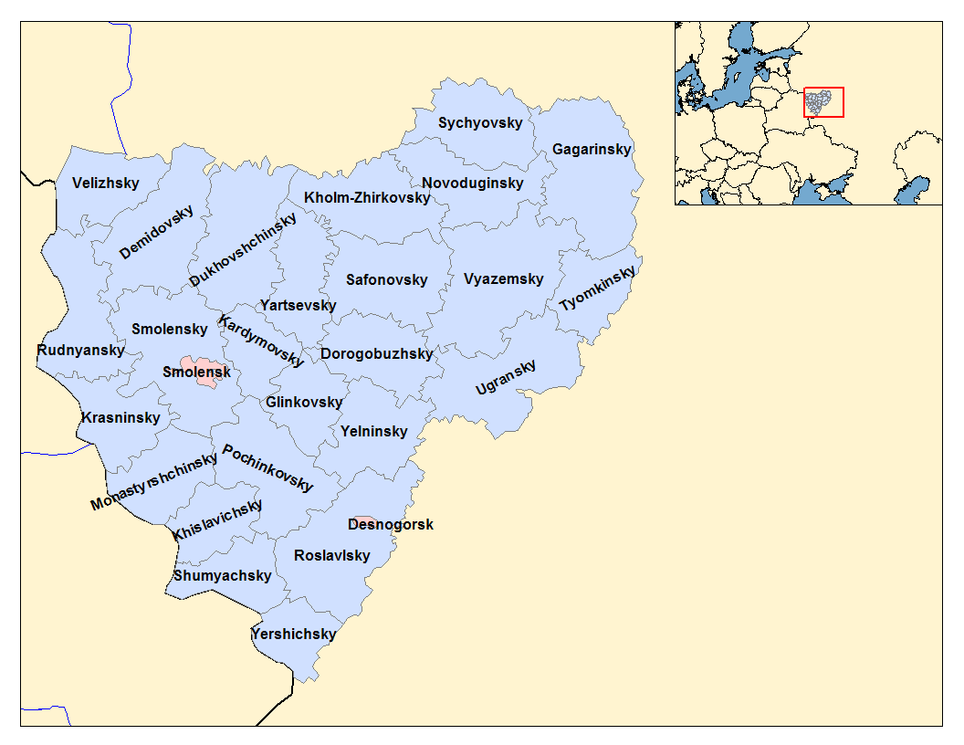
Smolensk Oblast (russian: Смоле́нская о́бласть, ''Smolenskaya oblast''; informal name — ''Smolenschina'' (russian: Смоле́нщина)) is a federal subject of Russia (an oblast). Its administrative centre is the city of Smolensk. As of the 2010 Census, its population was 985,537. Geography The oblast was founded on 27 September 1937.Исполнительный комитет Смоленского областного совета народных депутатов. Государственный архив Смоленской области. "Административно-территориальное устройство Смоленской области. Справочник", изд. "Московский рабочий", Москва 1981. Стр. 8 It borders Pskov Oblast in the north, Tver Oblast in the northeast, Moscow Oblast in the east, Kaluga Oblast in south, Bryansk Oblast in the southwest, and Mogilev and Vitebsk Oblast ... [...More Info...] [...Related Items...] OR: [Wikipedia] [Google] [Baidu] |
Minsk
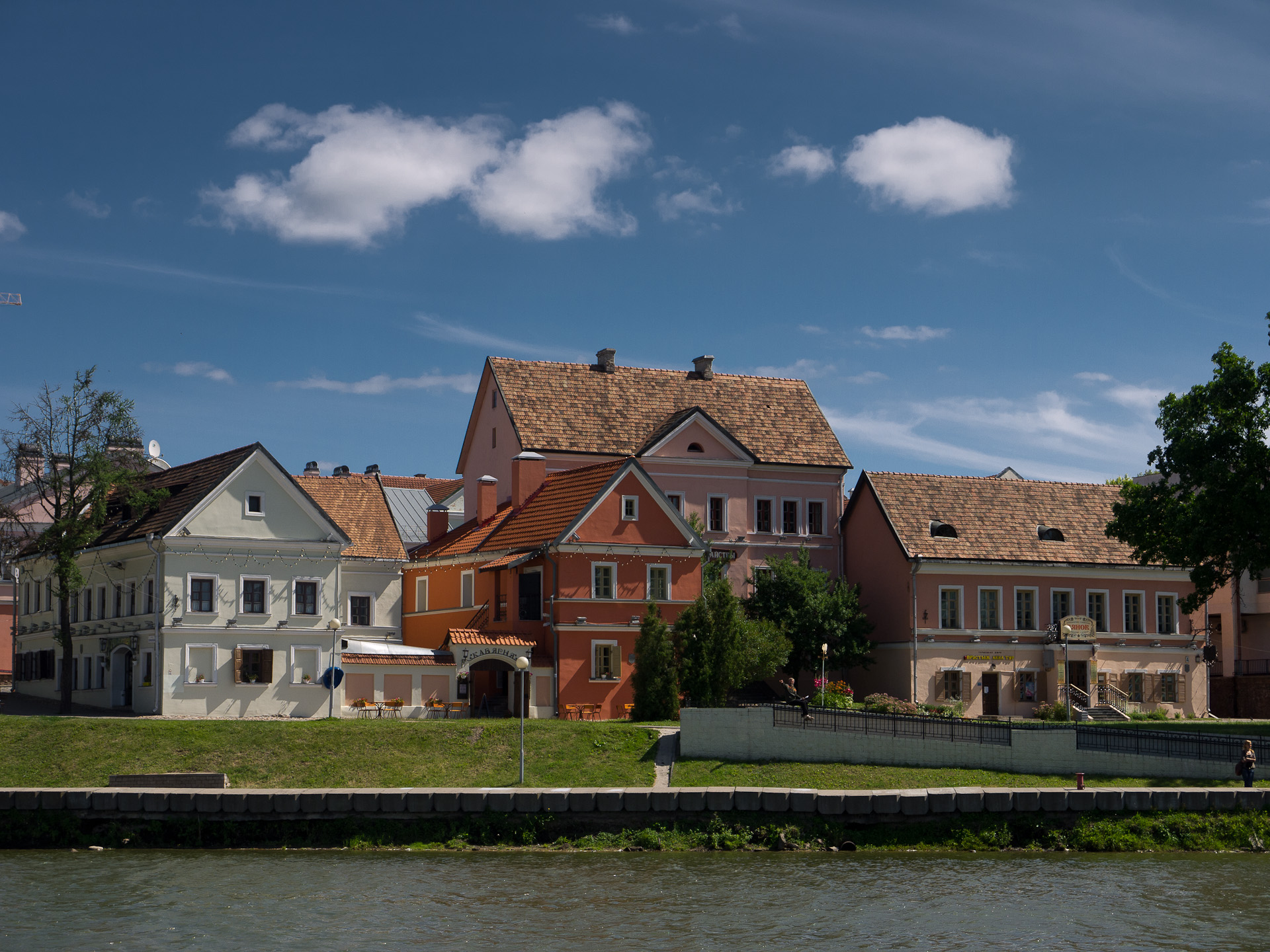
Minsk ( be, Мінск ; russian: Минск) is the capital and the largest city of Belarus, located on the Svislach and the now subterranean Niamiha rivers. As the capital, Minsk has a special administrative status in Belarus and is the administrative centre of Minsk Region (voblast) and Minsk District (raion). As of January 2021, its population was 2 million, making Minsk the 11th most populous city in Europe. Minsk is one of the administrative capitals of the Commonwealth of Independent States (CIS) and the Eurasian Economic Union (EAEU). First documented in 1067, Minsk became the capital of the Principality of Minsk before being annexed by the Grand Duchy of Lithuania in 1242. It received town privileges in 1499. From 1569, it was the capital of the Minsk Voivodeship, an administrative division of the Polish–Lithuanian Commonwealth. It was part of a region annexed by the Russian Empire in 1793, as a consequence of the Second Partition of Poland. From 1919 to 1991, aft ... [...More Info...] [...Related Items...] OR: [Wikipedia] [Google] [Baidu] |
Alytus County
Alytus County ( lt, Alytaus apskritis) is one of ten counties of Lithuania, counties in Lithuania. It is the southernmost county, and its Capital (political), capital is the city of Alytus. Its territory lies within the Regions of Lithuania, ethnographic region of Dzūkija. On 1 July 2010, the county administration was abolished, and since that date, Alytus County remains as the territorial and statistical unit. Municipalities The municipalities in Alytus County are: Geography The town of Druskininkai, a spa visited for its healing waters, is located in Alytus County, as is Grūtas Park, also known as ''Stalin World'', a Soviet Union, Soviet theme park. There are more than 420 lakes in Alytus County. Population by municipality References External links Social and demographic characteristics of Alytus CountyEconomy of Alytus CountyEnvironment of Alytus County {{Authority control Alytus County, Counties of Lithuania ... [...More Info...] [...Related Items...] OR: [Wikipedia] [Google] [Baidu] |
Wolin
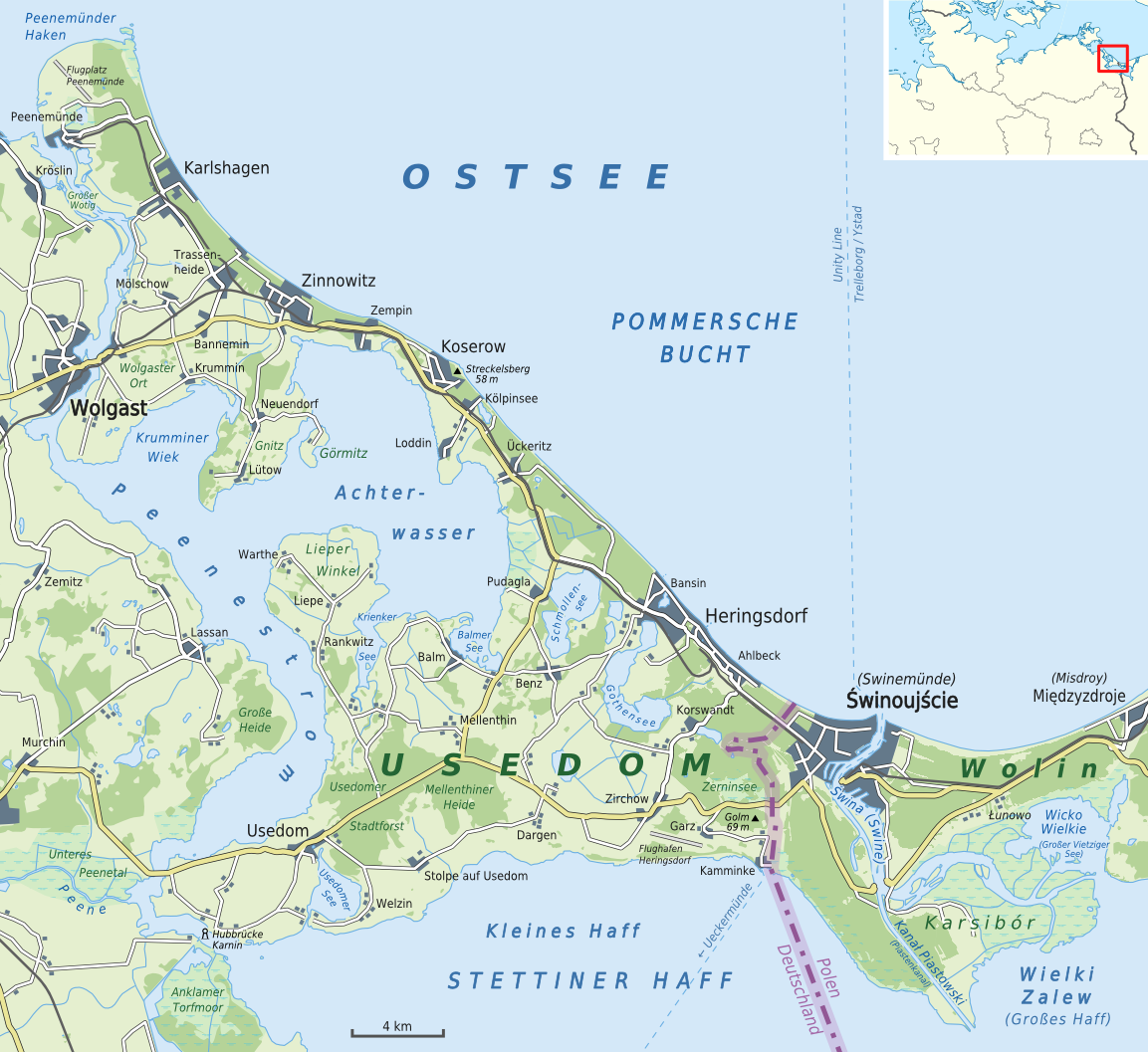
Wolin (; formerly german: Wollin ) is the name both of a Polish island in the Baltic Sea, just off the Polish coast, and a town on that island. Administratively, the island belongs to the West Pomeranian Voivodeship. Wolin is separated from the island of Usedom (Uznam) by the Strait of Świna, and from mainland Pomerania by the Strait of Dziwna. The island has an area of and its highest point is Mount Grzywacz at 116 m above sea level. The number of inhabitants is 30,000. Water from the river Oder flows into the Szczecin Lagoon and from there through the Peene west of Usedom, Świna and Dziwna into the Bay of Pomerania in the Baltic Sea. Most of the island consists of forests and postglacial hills. In the middle is the Wolin National Park. The island is the main tourist attraction of northwestern Poland, and it is crossed by several specially marked tourist trails, such as a trail from Międzyzdroje to Dziwnówek. There is a main, electrified rail line, which connects Szcze ... [...More Info...] [...Related Items...] OR: [Wikipedia] [Google] [Baidu] |
Usedom
Usedom (german: Usedom , pl, Uznam ) is a Baltic Sea island in Pomerania, divided between Germany and Poland. It is the second largest Pomeranian island after Rügen, and the most populous island in the Baltic Sea. It is north of the Szczecin Lagoon estuary of the Oder river. About 80% of the island belongs to the German district of Vorpommern-Greifswald in the state of Mecklenburg-Vorpommern. The eastern part and the largest city on the island, Świnoujście, are part of the Polish West Pomeranian Voivodeship. The island's total area is – in the German part and in the Polish part. Its population is 76,500 (German part 31,500; Polish part 45,000). With an annual average of 1,906 hours of sunshine, Usedom is the sunniest region of both Germany and Poland, and it is also one of the sunniest islands in the Baltic Sea, hence its nickname "Sun Island" (german: Sonneninsel, pl, Wyspa Słońca). The island has been a tourist destination since the Gründerzeit in the 19th centur ... [...More Info...] [...Related Items...] OR: [Wikipedia] [Google] [Baidu] |
Poel
Poel () or Poel Island (german: Insel Poel), is an island in the Baltic Sea. It forms the natural northern and eastern boundaries of the Bay of Wismar on the German coast. The northern coast of the island is also on the south side of the large gulf known as the Bay of Mecklenburg, which Wismar Bay enters into. Insel Poel thus forms on its northern side the unofficial latitude of the northern boundary of the Wismar Bay. It is close to the cities of Lübeck, Wismar and Schwerin and is part of the Hamburg Metropolitan Region. Administratively it is a municipality in the Nordwestmecklenburg district. It consists of Kirchdorf and Oertzenhof (the main towns) and the smaller villages of Timmendorf, Wangern, Hinterwangern, Weitendorf, Weitendorf-Hof, Brandenhusen, Neuhof, Seedorf, Niendorf, Schwarzer Busch, Kaltenhof, Fährdorf, Malchow, Vorwerk and Gollwitz. It covers an area of and has 2,873 citizens. Satellite pictures show that most of it is used as farmland. With its good air, cl ... [...More Info...] [...Related Items...] OR: [Wikipedia] [Google] [Baidu] |
Bay Of Wismar
The Bay of WismarKohl, Horst; Marcinek, Joachim and Nitz, Bernhard (1986). ''Geography of the German Democratic Republic'', VEB Hermann Haack, Gotha, p. 47. . or more commonly Wismar Bay or ''Wismarbucht'' is a well sheltered multi-sectioned bay in the southwestern Baltic Sea, in Mecklenburg-Vorpommern, Germany, and is considered the south-central part of the much larger arm of the Baltic known as the Mecklenburg Bay (or Mecklenburg Bight, for its long narrow bent shape)—a long fingerlike gulf oriented to the west-southwest (WSW) from the (central) Baltic proper. Wismar bay is considered one of the finest natural harbors on the Baltic, and served as the destination for much seaborne shipping until circa the 1910s when its minimum depths of became too shallow for larger more modern ships. Today, because of the shallow sheltered waters the bay is the subject of much research via underwater archeology There are four lobe like parts of the Bay of Wismar which are themselves bays ... [...More Info...] [...Related Items...] OR: [Wikipedia] [Google] [Baidu] |
Mecklenburg-Vorpommern
Mecklenburg-Vorpommern (MV; ; nds, Mäkelborg-Vörpommern), also known by its anglicized name Mecklenburg–Western Pomerania, is a state in the north-east of Germany. Of the country's sixteen states, Mecklenburg-Vorpommern ranks 14th in population; it covers an area of , making it the sixth largest German state in area; and it is 16th in population density. Schwerin is the state capital and Rostock is the largest city. Other major cities include Neubrandenburg, Stralsund, Greifswald, Wismar, and Güstrow. It was named after the 2 regions of Mecklenburg and Vorpommern (which means West Pomerania). The state was established in 1945 after World War II through the merger of the historic regions of Mecklenburg and the Prussian Western Pomerania by the Soviet military administration in Allied-occupied Germany. It became part of the German Democratic Republic in 1949, but was dissolved in 1952 during administrative reforms and its territory divided into the districts of R ... [...More Info...] [...Related Items...] OR: [Wikipedia] [Google] [Baidu] |
Bay Of Lübeck
The Bay of Lübeck (, ) is a basin in the southwestern Baltic Sea, off the shores of German states of Mecklenburg-Vorpommern and Schleswig-Holstein. It forms the southwestern part of the Bay of Mecklenburg. The main port is Travemünde, a borough of the city of Lübeck, at the mouth of river Trave. The Elbe–Lübeck Canal connects the Baltic Sea with the Elbe River. The bay is surrounded by the landstrips of Ostholstein and Nordwestmecklenburg. Located in the North of the Bay, the Hansa-Park amusement park creates a popular sight for families all around the region and Southern Denmark. The Pötenitzer Wiek lake splits the states of Schleswig-Holstein and Mecklenburg-Vorpommern and got historical attention, as it gave East Germany refugees the possibility to flee from East Germany in to West Germany. Gallery File:Lübecker Bucht, Seegebiet.jpg, File:Blick auf Nordermole und Lübecker Bucht.JPG File:Lübecker Bucht vom Hansapark aus gesehen - panoramio.jpg File:Lübecker Buc ... [...More Info...] [...Related Items...] OR: [Wikipedia] [Google] [Baidu] |
Baltic Sea
The Baltic Sea is an arm of the Atlantic Ocean that is enclosed by Denmark, Estonia, Finland, Germany, Latvia, Lithuania, Poland, Russia, Sweden and the North and Central European Plain. The sea stretches from 53°N to 66°N latitude and from 10°E to 30°E longitude. A marginal sea of the Atlantic, with limited water exchange between the two water bodies, the Baltic Sea drains through the Danish Straits into the Kattegat by way of the Øresund, Great Belt and Little Belt. It includes the Gulf of Bothnia, the Bay of Bothnia, the Gulf of Finland, the Gulf of Riga and the Bay of Gdańsk. The " Baltic Proper" is bordered on its northern edge, at latitude 60°N, by Åland and the Gulf of Bothnia, on its northeastern edge by the Gulf of Finland, on its eastern edge by the Gulf of Riga, and in the west by the Swedish part of the southern Scandinavian Peninsula. The Baltic Sea is connected by artificial waterways to the White Sea via the White Sea–Baltic Canal and to the German ... [...More Info...] [...Related Items...] OR: [Wikipedia] [Google] [Baidu] |

.jpg)


