|
45th Meridian East
The meridian 45° east of Greenwich is a line of longitude that extends from the North Pole across the Arctic Ocean, Europe, Asia, Africa, the Indian Ocean, the Southern Ocean, and Antarctica to the South Pole. The 45th meridian east forms a great circle with the 135th meridian west. The meridian is the mid point of the Moscow Time. From Pole to Pole Starting at the North Pole and heading south to the South Pole The South Pole, also known as the Geographic South Pole, Terrestrial South Pole or 90th Parallel South, is one of the two points where Earth's axis of rotation intersects its surface. It is the southernmost point on Earth and lies antipod ..., the 45th meridian east passes through: : See also * 44th meridian east * 46th meridian east {{geographical coordinates, state=collapsed e045 meridian east ... [...More Info...] [...Related Items...] OR: [Wikipedia] [Google] [Baidu] |
Prime Meridian
A prime meridian is an arbitrary meridian (a line of longitude) in a geographic coordinate system at which longitude is defined to be 0°. Together, a prime meridian and its anti-meridian (the 180th meridian in a 360°-system) form a great circle. This great circle divides a spheroid, like the Earth, into two hemispheres: the Eastern Hemisphere and the Western Hemisphere (for an east-west notational system). For Earth's prime meridian, various conventions have been used or advocated in different regions throughout history. The Earth's current international standard prime meridian is the IERS Reference Meridian. It is derived, but differs slightly, from the Greenwich Meridian, the previous standard. A prime meridian for a planetary body not tidally locked (or at least not in synchronous rotation) is entirely arbitrary, unlike an equator, which is determined by the axis of rotation. However, for celestial objects that are tidally locked (more specifically, synchronous), th ... [...More Info...] [...Related Items...] OR: [Wikipedia] [Google] [Baidu] |
Chesha Bay
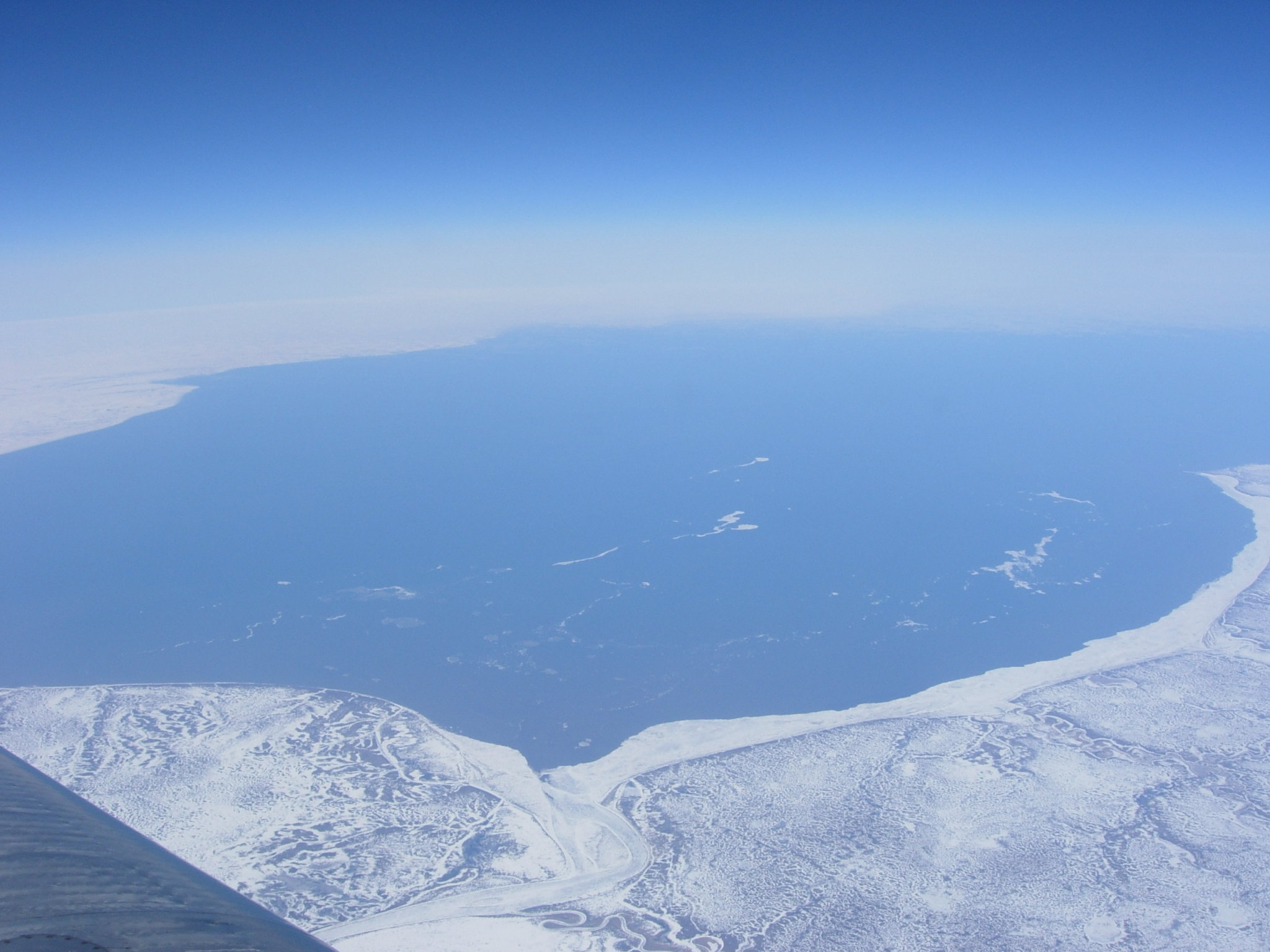
Chosha Bay (Choshskaya Guba, russian: Чёшская губа) is an inlet of the Barents Sea, 84 miles (135 km) wide and 62 miles (100 km) long, lies between the East shore of Kanin peninsula and the mainland of northern European Russia Russia (, , ), or the Russian Federation, is a List of transcontinental countries, transcontinental country spanning Eastern Europe and North Asia, Northern Asia. It is the List of countries and dependencies by area, largest country in the .... Bays of the Barents Sea Bays of Russia Bodies of water of Nenets Autonomous Okrug {{NenetsAutonomousOkrug-geo-stub ... [...More Info...] [...Related Items...] OR: [Wikipedia] [Google] [Baidu] |
Overseas Department
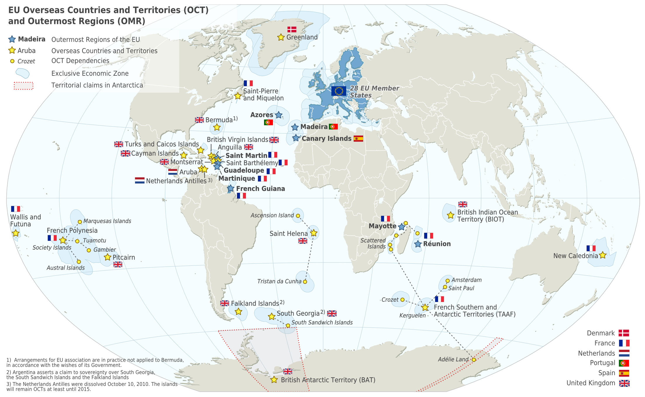
The overseas departments and regions of France (french: départements et régions d'outre-mer, ; ''DROM'') are departments of France that are outside metropolitan France, the European part of France. They have exactly the same status as mainland France's regions and departments. The French Constitution provides that, in general, French laws and regulations (France's civil code, penal code, administrative law, social laws, tax laws, etc.) apply to French overseas regions the same as in metropolitan France, but can be adapted as needed to suit the region's particular needs. Hence, the local administrations of French overseas regions cannot themselves pass new laws. As integral parts of France and the European Union, overseas departments are represented in the National Assembly, Senate, and Economic and Social Council, vote to elect members of the European Parliament (MEP), and also use the euro as their currency. The overseas departments and regions are not the same as the overs ... [...More Info...] [...Related Items...] OR: [Wikipedia] [Google] [Baidu] |
Mayotte
Mayotte (; french: Mayotte, ; Shimaore: ''Maore'', ; Kibushi: ''Maori'', ), officially the Department of Mayotte (french: Département de Mayotte), is an overseas department and region and single territorial collectivity of France. It is located in the northern part of the Mozambique Channel in the Indian Ocean off the coast of Southeastern Africa, between Northwestern Madagascar and Northeastern Mozambique. Mayotte consists of a main island, Grande-Terre (or Maore), a smaller island, Petite-Terre (or Pamanzi), as well as several islets around these two. Mayotte is the most prosperous territory in the Mozambique Channel, making it a major destination for immigration. Mayotte's land area is and, with its 299,348 people according to January 2022 official estimates, is very densely populated at 800 inhabitants per km2 (2,073 per sq mi). The biggest city and prefecture is Mamoudzou on Grande-Terre. The Dzaoudzi–Pamandzi International Airport is located on the neighbouring is ... [...More Info...] [...Related Items...] OR: [Wikipedia] [Google] [Baidu] |
Berbera
Berbera (; so, Barbara, ar, بربرة) is the capital of the Sahil region of Somaliland and is the main sea port of the country. Berbera is a coastal city and was the former capital of the British Somaliland protectorate before Hargeisa. It also served as a major port of the Ifat, Adal and Isaaq sultanates from the 13th to 19th centuries. In antiquity, Berbera was part of a chain of commercial port cities along the Somali seaboard. During the early modern period, Berbera was the most important place of trade in the Somali Peninsula. It later served as the capital of the British Somaliland protectorate from 1884 to 1941, when it was replaced by Hargeisa. In 1960, the British Somaliland protectorate gained independence as the State of Somaliland and united five days later with the Trust Territory of Somalia (the former Italian Somalia) to form the Somali Republic.Encyclopædia Britannica, ''The New Encyclopædia Britannica'', (Encyclopædia Britannica: 2002), p.835 Located s ... [...More Info...] [...Related Items...] OR: [Wikipedia] [Google] [Baidu] |
Somaliland
Somaliland,; ar, صوماليلاند ', ' officially the Republic of Somaliland,, ar, جمهورية صوماليلاند, link=no ''Jumhūrīyat Ṣūmālīlānd'' is a ''de facto'' sovereign state in the Horn of Africa, still considered internationally to be part of Somalia. Somaliland lies in the Horn of Africa, on the southern coast of the Gulf of Aden. It is bordered by Djibouti to the northwest, Ethiopia to the south and west, and Somalia to the east.Encyclopædia Britannica, ''The New Encyclopædia Britannica'', (Encyclopædia Britannica: 2002), p.835 Its claimed territory has an area of , with approximately 5.7 million residents as of 2021. The capital and largest city is Hargeisa. The government of Somaliland regards itself as the successor state to British Somaliland, which, as the briefly independent State of Somaliland, united in 1960 with the Trust Territory of Somaliland (the former Italian Somaliland) to form the Somali Republic.''The New Encyclopædia Br ... [...More Info...] [...Related Items...] OR: [Wikipedia] [Google] [Baidu] |
Gulf Of Aden
The Gulf of Aden ( ar, خليج عدن, so, Gacanka Cadmeed 𐒅𐒖𐒐𐒕𐒌 𐒋𐒖𐒆𐒗𐒒) is a deepwater gulf of the Indian Ocean between Yemen to the north, the Arabian Sea to the east, Djibouti to the west, and the Guardafui Channel, Socotra and Somalia to the south. In the northwest, it connects with the Red Sea through the Bab-el-Mandeb strait, and it connects with the Arabian Sea to the east. To the west, it narrows into the Gulf of Tadjoura in Djibouti. The ancient Greeks regarded the gulf as one of the most important parts of the Erythraean Sea. It later came to be dominated by Muslims, as the area around the gulf converted to Islam. From the late 1960s onwards, there started to be an increased Soviet naval presence in the Gulf. The importance of the Gulf of Aden declined when the Suez Canal was closed, but it was revitalized when the canal was reopened in 1975, after being deepened and widened by the Egyptian government. The waterway is part of the importa ... [...More Info...] [...Related Items...] OR: [Wikipedia] [Google] [Baidu] |
Aden
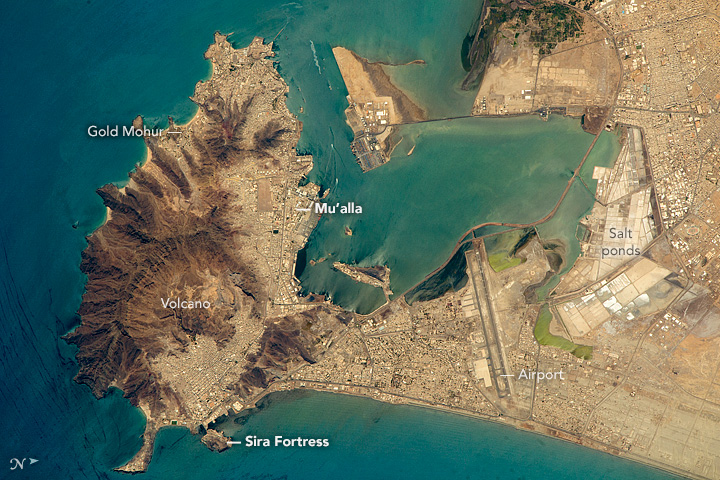
Aden ( ar, عدن ' Yemeni: ) is a city, and since 2015, the temporary capital of Yemen, near the eastern approach to the Red Sea (the Gulf of Aden), some east of the strait Bab-el-Mandeb. Its population is approximately 800,000 people. Aden's natural harbour lies in the crater of a dormant volcano, which now forms a peninsula joined to the mainland by a low isthmus. This harbour, Front Bay, was first used by the ancient Kingdom of Awsan between the 7th to 5th centuries BC. The modern harbour is on the other side of the peninsula. Aden gets its name from the Gulf of Aden. Aden consists of a number of distinct sub-centres: Crater, the original port city; Ma'alla, the modern port; Tawahi, known as "Steamer Point" in the colonial period; and the resorts of Gold Mohur. Khormaksar, on the isthmus that connects Aden proper with the mainland, includes the city's diplomatic missions, the main offices of Aden University, and Aden International Airport (the former British Roy ... [...More Info...] [...Related Items...] OR: [Wikipedia] [Google] [Baidu] |
Urmia
Urmia or Orumiyeh ( fa, ارومیه, Variously transliterated as ''Oroumieh'', ''Oroumiyeh'', ''Orūmīyeh'' and ''Urūmiyeh''.) is the largest city in West Azerbaijan Province of Iran and the capital of Urmia County. It is situated at an altitude of above sea level, and is located along the Shahar River on the Urmia Plain. Lake Urmia, one of the world's largest salt lakes, lies to the east of the city, and the mountainous Turkish border area lies to the west. Urmia is the 10th-most populous city in Iran. At the 2012 census, its population was 667,499, with 197,749 households. The majority of the city's residents are Azerbaijanis, with a large minority of Kurds, and a smaller number of Assyrians, and Armenians, as well as Persian-speakers who moved to the city mostly for employment. The city is the trading center for a fertile agricultural region where fruits (especially apples and grapes) and tobacco are grown. Even though the majority of the residents of Urmia are Musli ... [...More Info...] [...Related Items...] OR: [Wikipedia] [Google] [Baidu] |
Nakhchivan Autonomous Republic
The Nakhchivan Autonomous Republic ( az, Naxçıvan Muxtar Respublikası, ), is a landlocked exclave of the Republic of Azerbaijan. The region covers Official portal of Nakhchivan Autonomous RepublicNakhchivan Autonomous Republic with a population of 459,600 bordered by Armenia to the east and north, Iran to the southwest, and Turkey to the west. The republic, especially the capital city of Nakhchivan, has a long history dating back to about 1500 BCE. ''Nakhijevan'' was one the cantons of the historical Armenian province of Vaspurakan in the Kingdom of Armenia. Historically though, the Persians, Armenians, Mongols, and Turks all competed for the region. The area that is now Nakhchivan became part of Safavid Iran in the 16th century. In 1828, after the last Russo-Persian War and the Treaty of Turkmenchay, the Nakhchivan Khanate passed from Iranian into Imperial Russian possession. After the 1917 February Revolution, Nakhchivan and its surrounding region were under the autho ... [...More Info...] [...Related Items...] OR: [Wikipedia] [Google] [Baidu] |
Lake Sevan
Lake Sevan ( hy, Սևանա լիճ, Sevana lich) is the largest body of water in both Armenia and the Caucasus region. It is one of the largest freshwater high-altitude (alpine) lakes in Eurasia. The lake is situated in Gegharkunik Province, at an altitude of above sea level. The total surface area of its basin is about , which makes up of Armenia's territory. The lake itself is , and the volume is . It is fed by 28 rivers and streams. Only 10% of the incoming water is drained by the Hrazdan River, while the remaining 90% evaporates. The lake provides some 90% of the fish and 80% of the crayfish catch of Armenia. Sevan has significant economic, cultural, and recreational value. Its sole major island (now a peninsula) is home to a medieval monastery. Sevan was heavily exploited for irrigation of the Ararat plain and hydroelectric power generation during the Soviet period. Consequently, its water level decreased by around and its volume reduced by more than 40%. Later two ... [...More Info...] [...Related Items...] OR: [Wikipedia] [Google] [Baidu] |
Exclave
An enclave is a territory (or a small territory apart of a larger one) that is entirely surrounded by the territory of one other state or entity. Enclaves may also exist within territorial waters. ''Enclave'' is sometimes used improperly to denote a territory that is only partly surrounded by another state. The Vatican City and San Marino, both enclaved by Italy, and Lesotho, enclaved by South Africa, are completely enclaved sovereign states. An exclave is a portion of a state or district geographically separated from the main part by surrounding alien territory (of one or more states or districts etc). Many exclaves are also enclaves, but not all: an exclave can be surrounded by the territory of more than one state. The Azerbaijani exclave of Nakhchivan is an example of an exclave that is not an enclave, as it borders Armenia, Turkey and Iran. Semi-enclaves and semi-exclaves are areas that, except for possessing an unsurrounded sea border (a coastline contiguous with internati ... [...More Info...] [...Related Items...] OR: [Wikipedia] [Google] [Baidu] |
_033.jpg)


