|
1990 Carlentini Earthquake
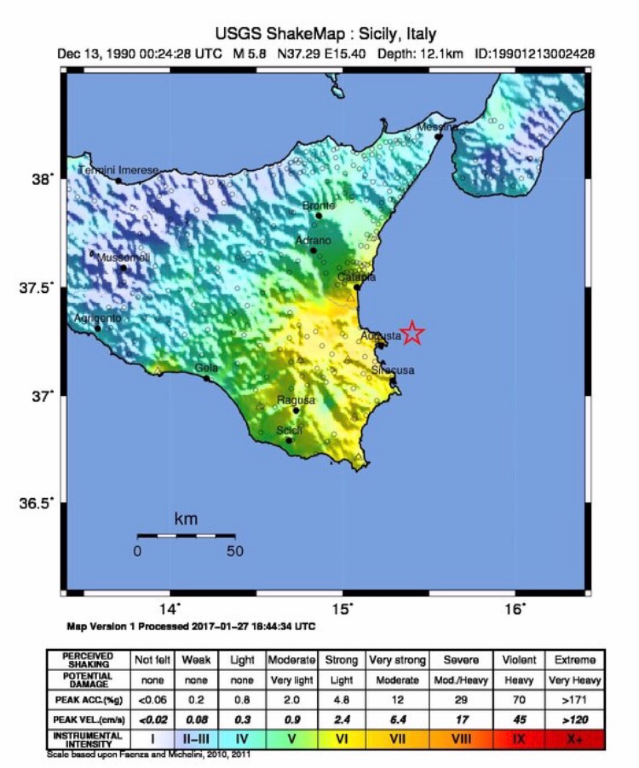
The 1990 Carlentini earthquake (Italian: ''Terremoto di Carlentini del 1990'') occurred off the Sicilian coast, 20 km east northeast from the town of Augusta, Sicily on 13 December at 01:24 local time. The moderately-sized earthquake measuring 5.6 on the moment magnitude scale () resulted in the deaths of 19 people and caused at least 200 injuries. It also inflicted significant damage in the region, leaving 2,500 homeless. Lasting 45 seconds, the shock was assigned a maximum Modified Mercalli intensity of VII–VIII (''Very strong–Severe''). The earthquake was followed-up by four aftershocks that were felt by people. Tectonic setting The island of Sicily is situated near the edge of a convergent plate boundary where the African Plate is colliding with Eurasia. The denser African Plate subducts or dives beneath the Eurasian Plate. Subduction occurs offshore in the Mediterranean Sea along the Calabrian subduction zone. The presence of active subduction makes Sicily a seis ... [...More Info...] [...Related Items...] OR: [Wikipedia] [Google] [Baidu] |
Eastern European Time
Eastern European Time (EET) is one of the names of UTC+02:00 time zone, 2 hours ahead of Coordinated Universal Time. The zone uses daylight saving time, so that it uses UTC+03:00 during the summer. A number of African countries use UTC+02:00 all year long, where it is called Central Africa Time (CAT), although Egypt and Libya also use the term ''Eastern European Time''. The most populous city in the Eastern European Time zone is Cairo, with the most populous EET city in Europe being Athens. Usage The following countries, parts of countries, and territories use Eastern European Time all year round: * Egypt, since 21 April 2015; used EEST ( UTC+02:00; UTC+03:00 with daylight saving time) from 1988–2010 and 16 May–26 September 2014. See also Egypt Standard Time. * Kaliningrad Oblast (Russia), since 26 October 2014; also used EET in years 1945 and 1991–2011. See also Kaliningrad Time. * Libya, since 27 October 2013; switched from Central European Time, which was u ... [...More Info...] [...Related Items...] OR: [Wikipedia] [Google] [Baidu] |
Foreshocks
A foreshock is an earthquake that occurs before a larger seismic event (the mainshock) and is related to it in both time and space. The designation of an earthquake as ''foreshock'', ''mainshock'' or aftershock is only possible after the full sequence of events has happened. Occurrence Foreshock activity has been detected for about 40% of all moderate to large earthquakes, and about 70% for events of M>7.0. They occur from a matter of minutes to days or even longer before the main shock; for example, the 2002 Sumatra earthquake is regarded as a foreshock of the 2004 Indian Ocean earthquake with a delay of more than two years between the two events. Some great earthquakes (M>8.0) show no foreshock activity at all, such as the M8.6 1950 India–China earthquake. The increase in foreshock activity is difficult to quantify for individual earthquakes but becomes apparent when combining the results of many different events. From such combined observations, the increase before the m ... [...More Info...] [...Related Items...] OR: [Wikipedia] [Google] [Baidu] |
Niscemi
Niscemi is a little town and ''comune'' in the province of Caltanissetta, Sicily, Italy. It has a population of 27,558. It is located not far from Gela and Caltagirone and 90 km from Catania. Etymology The name Niscemi is derived from the Arabic word ''نَشَم neshem'' or its singular form ''نَشَمَة neshemeh'', this being the name of a particular type of tree. Main Sights * Santa Maria d'Itria: chiesa madre or mother church of town World War II During World War II, Niscemi was the location of ''Ponte Olivo Airfield'', a military airfield used by the United States Twelfth Air Force during the Italian campaign. After the war the area was redeveloped and no evidence of the wartime airfield remains. American military installation Today, there is a military radio station for naval communication, U.S. Naval Radio Transmitter Facility (NRTF) Niscemi. Its tallest antenna is a guyed mast, high, situated at 37°7'32"N 14°26'11"E. The United States Navy installation ... [...More Info...] [...Related Items...] OR: [Wikipedia] [Google] [Baidu] |
Catania
Catania (, , Sicilian and ) is the second largest municipality in Sicily, after Palermo. Despite its reputation as the second city of the island, Catania is the largest Sicilian conurbation, among the largest in Italy, as evidenced also by the presence of important road and rail transport infrastructures as well as by the main airport in Sicily, fifth in Italy. It is located on Sicily's east coast, at the base of the active volcano, Mount Etna, and it faces the Ionian Sea. It is the capital of the 58-municipality region known as the Metropolitan City of Catania, which is the seventh-largest metropolitan city in Italy. The population of the city proper is 311,584, while the population of the Metropolitan City of Catania is 1,107,702. Catania was founded in the 8th century BC by Chalcidian Greeks. The city has weathered multiple geologic catastrophes: it was almost completely destroyed by a catastrophic earthquake in 1169. A major eruption and lava flow from nearby Mount ... [...More Info...] [...Related Items...] OR: [Wikipedia] [Google] [Baidu] |
Lentini
Lentini ( scn, Lintini, historically Liuntini; la, Leontīnī; grc, Λεοντῖνοι) is a town and in the Province of Syracuse, South East of Sicily (Southern Italy). History The city was founded by colonists from Naxos as Leontini in 729 BC, which in its beginnings was a Chalcidian colony established five years earlier. It is virtually the only Greek settlement in Sicily that is not located on the coast, founded around 10 km inland. The site, originally held by the Sicels, was seized by the Greeks owing to their command on the fertile plain in the north. The city was reduced to subject status in 494 BC by Hippocrates of Gela, who made his ally Aenesidemus its tyrant. In 476 BC, Hieron of Syracuse moved the inhabitants from Catana and Naxos to Leontini. Later on, the city of Leontini regained its independence. However, as a part of the inhabitants efforts to retain their independence, they invoked more than once the interventions of Athens. It was mainly the eloqu ... [...More Info...] [...Related Items...] OR: [Wikipedia] [Google] [Baidu] |
Carlentini
Carlentini ( Sicilian: ''Carruntini'') is a town and ''comune'' in the Province of Syracuse, Sicily (Italy). It lies 45 km (28 mi) outside the provincial capital of Syracuse. The city's name has its origins in the neighboring town of Lentini. In 1551, Vice-King Giovanni De Vega founded a new city in honour of Emperor Carlo V, naming it in Latin ''Carleontini'', or ''Leontini of Carlo''. In Italian, it became ''Carlentini'', and in the various Sicilian dialects, ''Carrintini'' or ''Carruntini''. Among the churches in town are: * Chiesa Madre dedicated to the Immacolata Concezione *Santa Maria di Roccadia *San Sebastiano *Madonna delle Grazie Twin towns – sister cities Carlentini is twinned with: * Santa Luċija Santa Luċija ( en, Saint Lucia) is a village in the Southern Region of Malta, with a population of 2,997 as of March 2014. It is one of the modern towns developed in Malta during the 20th century. By virtue of an article which appeared in Gove ..., ... [...More Info...] [...Related Items...] OR: [Wikipedia] [Google] [Baidu] |
Ragusa Province
The Province of Ragusa ( it, Provincia di Ragusa; Sicilian: ''Pruvincia 'i Rausa'') was a province in the autonomous region of Sicily in southern Italy, located in the south-east of the island. Following the abolition of the Sicilian provinces, it was replaced in 2015 by the Free municipal consortium of Ragusa. Its capital is the city of Ragusa, which is the most southerly provincial capital in Italy. Geography From Scoglitti to Pozzallo, the Ragusan coastline is approximately long. Along the Ragusan coast are many fishing villages such as Kaukana, Punta Secca, Marina di Ragusa and Marina di Modica. The Hyblaean Mountains are dominating the north of the province and its highest peaks are Monte Lauro, Monte Casale and Monte Arcibessi. The rivers of the province are the Irminio, Dirillo and Ippari and the only lake in the province is the Lago di Santa Rosalia along the course of the Irminio river. The skyline of Ragusa is punctuated by the towers, domes and cupolas of the ... [...More Info...] [...Related Items...] OR: [Wikipedia] [Google] [Baidu] |
Catania Province
The Province of Catania ( it, Provincia di Catania; scn, Pruvincia di Catania) was a province in the autonomous island region of Sicily in southern Italy. Its capital was the city of Catania. It had an area of and a total population of about 1,116,917 as of 31 December 2014. Historically known also as ''Val di Catania'',, with the administrative meaning of Province of Catania, from sqr, وَلاية, wālāya (based on ar, وَلِيّ, wālī), but also used with the geographical meaning of Catania Valley, from la, vallis. it included until 1927 a large part of the Province of Enna. It was replaced by the Metropolitan City of Catania starting from 4 August 2015. History The Province of Catania was founded by Greeks, in 729 B.C. It was conquered by the Roman, in the First Punic War, in 263 BC. It had experienced many volcanic eruptions from the Mount Etna, of which the first eruption was recorded in 475 BC. It was hit by a devastating earthquake in 1169, which caused an ... [...More Info...] [...Related Items...] OR: [Wikipedia] [Google] [Baidu] |
Syracuse Province
The Province of Syracuse ( it, provincia di Siracusa; scn, pruvincia di Sarausa) was a province in the autonomous island region of Sicily in Italy. Its capital was the city of Syracuse, a town established by Greek colonists arriving from Corinth in the 8th century BC. It had an area of and a total population of 403,985 (2016). Syracuse had 8% of the Sicilian population and 8.2% of Sicily's area. Following the suppression of the Sicilian provinces, it was replaced in August 2015 by the Free municipal consortium of Syracuse ( it, Libero consorzio comunale di Siracusa, links=no). Geography and heritage The Province of Syracuse lies in the southeastern Sicily, in southwestern Italy. It is bordered to the north and north-west by the Province of Catania to the west by the Province of Ragusa, and to the east and south by the Ionian and Mediterranean seas. It occupies an area of . In 2002, ancient centres of Noto, Palazzolo Acreide and six other towns in the Noto Valley, were awarded U ... [...More Info...] [...Related Items...] OR: [Wikipedia] [Google] [Baidu] |
Mineo
Mineo ( scn, Minìu, Greek: ''Menaion'' and ''Μεναί'', Latin: ''Menaeum'' and ''Menaenum'') is a town and ''comune'' in the Metropolitan City of Catania, part of Sicily. It lies southwest of Catania, from Ragusa, from Gela, and from Caltagirone. It has approximately 5,600 inhabitants. It serves as the center of the cult of Saint Agrippina of Mineo. Among the churches in the town are: * Sant'Agrippina * Santi Pietro e Paolo * Santa Maria Maggiore It is also a site of interest since Luigi Capuana, one of Italy Italy ( it, Italia ), officially the Italian Republic, ) or the Republic of Italy, is a country in Southern Europe. It is located in the middle of the Mediterranean Sea, and its territory largely coincides with the homonymous geographical ...'s most famous writers in the 19th and early 20th centuries, hailed from Mineo and was at one time the town's mayor. Mineo now houses a small library and museum dedicated to Capuana. References Municipal ... [...More Info...] [...Related Items...] OR: [Wikipedia] [Google] [Baidu] |
Scordia
Scordia ( scn, Scurdìa) is a ''comune'' (municipality) in the Metropolitan City of Catania in the Italian region Sicily, located about southeast of Palermo and about southwest of Catania. Scordia borders the following municipalities: Lentini Lentini ( scn, Lintini, historically Liuntini; la, Leontīnī; grc, Λεοντῖνοι) is a town and in the Province of Syracuse, South East of Sicily (Southern Italy). History The city was founded by colonists from Naxos as Leontini in 72 ..., Militello in Val di Catania. References External links Official website Cities and towns in Sicily {{Sicily-geo-stub ... [...More Info...] [...Related Items...] OR: [Wikipedia] [Google] [Baidu] |
Brucoli
Brucoli ( scn, Brùculi) is a southern Italian hamlet (''frazione'') of Augusta, a municipality part of the Province of Syracuse, Sicily. Brucoli is located by the Ionian Sea coast of the island of Sicily and is from Augusta. It has a population of 1,098. At the ancient time, it was a colony of Megara Megara (; el, Μέγαρα, ) is a historic town and a municipality in West Attica, Greece. It lies in the northern section of the Isthmus of Corinth opposite the island of Salamis, which belonged to Megara in archaic times, before being take ... founded by the Megarian Lamis ( grc, Λάμις) and called Trotilon ( grc, Τρώτιλον). Gallery File:Brucoli_Village.jpg , Panorama File:Brucoli - Castle and Lighthouse.jpg , Lighthouse and castle File:Brucoli Castel - Castello di Brucoli.jpg, The castle of Brucoli File:Chiesa di San Nicola di Bari, Brucoli.JPG , Saint Nicholas church References External links * Frazioni of the Province of Syracuse Ancient cities ... [...More Info...] [...Related Items...] OR: [Wikipedia] [Google] [Baidu] |


