|
1970 Caribbean–Azores Hurricane
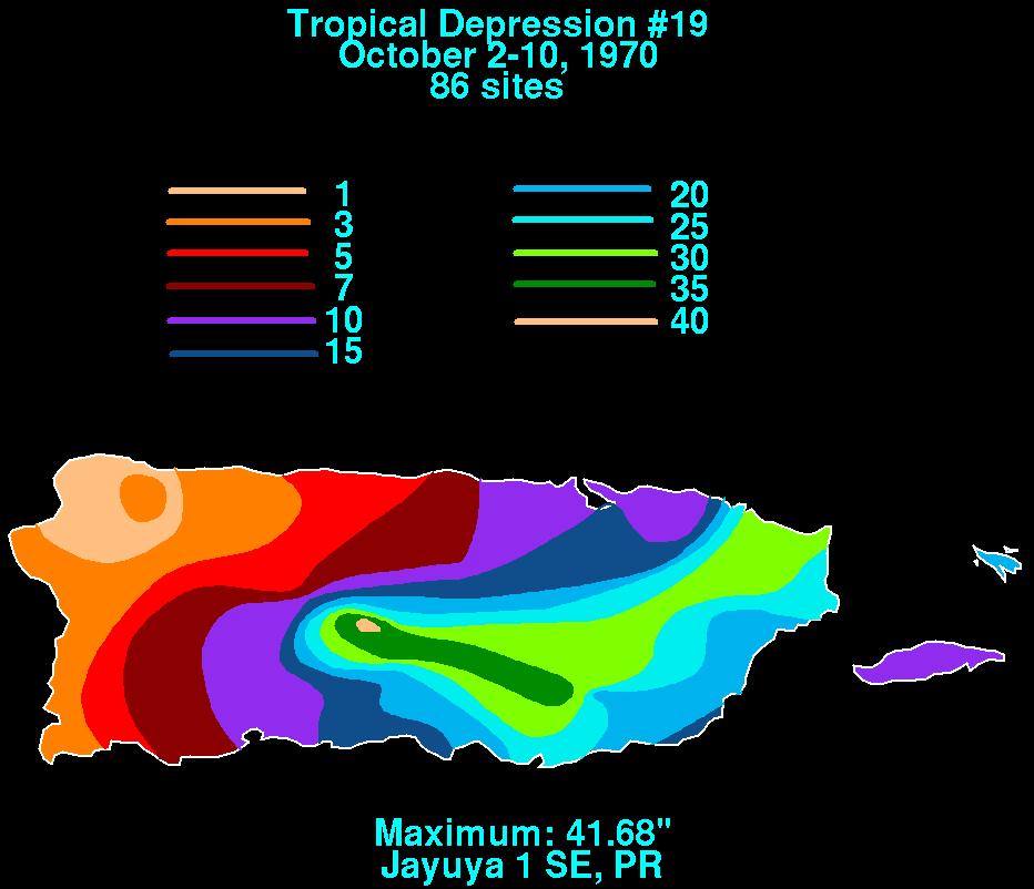
The 1970 Caribbean–Azores hurricane was an unnamed Atlantic hurricane that became the wettest known tropical cyclone on record to affect the United States territory of Puerto Rico. The long-lived system formed on September 24 just off the west coast of Africa, and for several days maintained a general westward track. It passed through the Lesser Antilles on October 1, and later stalled in the eastern Caribbean Sea. On October 8, the depression crossed over the Dominican Republic, and subsequently it accelerated to the northeast. It was declassified as a tropical cyclone on October 12, although its remnants persisted for another week before dissipating in the westerlies near the Azores. The depression produced heavy rainfall in the Lesser Antilles, reaching on Barbados; it left three deaths and moderate damage on the island. Another death was reported in the United States Virgin Islands. Torrential rainfall on Puerto Rico inflicted heavy damage, totaling $65 ... [...More Info...] [...Related Items...] OR: [Wikipedia] [Google] [Baidu] |
Lesser Antilles
The Lesser Antilles is a group of islands in the Caribbean Sea, forming part of the West Indies in Caribbean, Caribbean region of the Americas. They are distinguished from the larger islands of the Greater Antilles to the west. They form an arc which begins east of Geography of Puerto Rico, Puerto Rico at the Virgin Islands, archipelago of the Virgin Islands, swings southeast through the Leeward Islands, Leeward and Windward Islands towards South America, and turns westward through the Leeward Antilles along the Geography of Venezuela, Venezuelan coast. Most of them are part of a long, partially volcanic arc, volcanic island arc between the Greater Antilles to the north-west and the continent of South America."West Indies." ''Merriam-Webster's Geographical Dictionary'', 3rd ed. 2001. () Springfield, MA: Merriam-Webster Inc., p. 1298. The islands of the Lesser Antilles form the eastern boundary of the Caribbean Sea where it meets the Atlantic Ocean. Together, the Lesser Antilles a ... [...More Info...] [...Related Items...] OR: [Wikipedia] [Google] [Baidu] |
Guinea
Guinea, officially the Republic of Guinea, is a coastal country in West Africa. It borders the Atlantic Ocean to the west, Guinea-Bissau to the northwest, Senegal to the north, Mali to the northeast, Côte d'Ivoire to the southeast, and Sierra Leone and Liberia to the south. It is sometimes referred to as Guinea-Conakry, after its capital Conakry, to distinguish it from other territories in the Guinea (region), eponymous region, such as Guinea-Bissau and Equatorial Guinea. Guinea has a population of 14 million and an area of . Formerly French Guinea, it achieved independence in 1958. Guinea has a history of military coup d'état, coups d'état.Nicholas Bariyo & Benoit FauconMilitary Faction Stages Coup in Mineral-Rich Guinea ''Wall Street Journal'' (5 September 2021).Krista LarsonEXPLAINER: Why is history repeating itself in Guinea's coup? Associated Press (7 September 2021).Danielle PaquettHere's what we know about the unfolding coup in Guinea ''Washington Post'' (6 Septembe ... [...More Info...] [...Related Items...] OR: [Wikipedia] [Google] [Baidu] |
Saint Vincent (Antilles)
Saint Vincent is a volcanic island in the Caribbean. It is the largest island of the country Saint Vincent and the Grenadines and is located in the Caribbean Sea, between Saint Lucia and Grenada. It is composed of partially submerged volcanic mountains. Its largest volcano and the country's highest peak, Soufrière (volcano), La Soufrière, is active, with the latest episode of volcanic activity having begun in December 2020 and intensifying in April 2021. There were major territory wars between the indigenous population of the Black Caribs, also called the Garifuna, and Great Britain in the 18th century, before the island was ceded to the British in 1763, and again in 1783. Saint Vincent and the Grenadines gained independence from the United Kingdom on 27 October 1979, and became part of the British Commonwealth of Nations thereafter. Approximately 130,000 people currently live on the island, and the population saw significant migration to the UK in the early 1900s, and betwee ... [...More Info...] [...Related Items...] OR: [Wikipedia] [Google] [Baidu] |
Tropical Depression Nineteen 1970 Rainfall
The tropics are the regions of Earth surrounding the equator, where the sun may shine Effect of Sun angle on climate, directly overhead. This contrasts with the temperate or Polar regions of Earth, polar regions of Earth, where the Sun can never be directly overhead. This is because of Axial tilt#Earth, Earth's axial tilt; the width of the tropics (in latitude) is twice the tilt. The tropics are also referred to as the tropical zone and the torrid zone (see geographical zone). Due to the overhead sun, the tropics insolation, receive the most solar energy over the course of the year, and consequently have the highest temperatures on the planet. Even when not directly overhead, the sun is still close to overhead throughout the year, therefore the tropics also have the lowest seasonal variation on the planet; "winter" and "summer" lose their temperature contrast. Instead, seasons are more commonly divided Season#Tropical, by precipitation variations than by temperature variations. ... [...More Info...] [...Related Items...] OR: [Wikipedia] [Google] [Baidu] |


