|
1891–92 Scottish Cup
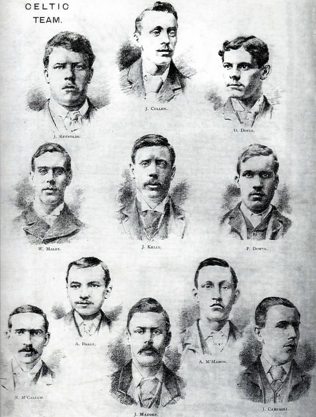
The 1891–92 Scottish Cup was the 19th season of Scotland's most prestigious football knockout competition. The Cup was won by Celtic when they beat Queen's Park 5–1 in the final after a replay. Calendar Fifth round * Match Abandoned Fifth round replay Sixth round Sixth round replay Sixth round second replay Quarter-final Quarter-final replay Quarter-final second replay Semi-finals Semi-final replay Final Match declared void due to repeated crowd encroachment. The Scottish Referee, 14 March 1892, scan via London Hearts Supporters Club Final replay Teams See also * 1891–92 in ...[...More Info...] [...Related Items...] OR: [Wikipedia] [Google] [Baidu] |
Scotland
Scotland (, ) is a country that is part of the United Kingdom. Covering the northern third of the island of Great Britain, mainland Scotland has a border with England to the southeast and is otherwise surrounded by the Atlantic Ocean to the north and west, the North Sea to the northeast and east, and the Irish Sea to the south. It also contains more than 790 islands, principally in the archipelagos of the Hebrides and the Northern Isles. Most of the population, including the capital Edinburgh, is concentrated in the Central Belt—the plain between the Scottish Highlands and the Southern Uplands—in the Scottish Lowlands. Scotland is divided into 32 administrative subdivisions or local authorities, known as council areas. Glasgow City is the largest council area in terms of population, with Highland being the largest in terms of area. Limited self-governing power, covering matters such as education, social services and roads and transportation, is devolved from the Scott ... [...More Info...] [...Related Items...] OR: [Wikipedia] [Google] [Baidu] |
Cambuslang F
Cambuslang ( sco, Cammuslang, from gd, Camas Lang) is a town on the south-eastern outskirts of Greater Glasgow, Scotland. With approximately 30,000 residents, it is the 27th largest town in Scotland by population, although, never having had a town hall, it may also be considered the largest village in Scotland. It is within the local authority area of South Lanarkshire and directly borders the town of Rutherglen to the west. Historically, it was a large civil parish incorporating the nearby hamlets of Newton, Flemington, Westburn and Halfway. Cambuslang is located just south of the River Clyde and about southeast of the centre of Glasgow. It has a long history of coal mining, from at least 1490, iron and steel making, and ancillary engineering works, most recently The Hoover Company (in the town from 1946 to 2005). The Clydebridge Steelworks and other smaller manufacturing businesses continue but most employment in the area comes from the distribution or service industries ... [...More Info...] [...Related Items...] OR: [Wikipedia] [Google] [Baidu] |
Arbroath F
Arbroath () or Aberbrothock ( gd, Obar Bhrothaig ) is a former royal burgh and the largest town in the council area of Angus, Scotland, with a population of 23,902. It lies on the North Sea coast some ENE of Dundee and SSW of Aberdeen. There is evidence of Iron Age settlement, but its history as a town began with the founding of Arbroath Abbey in 1178. It grew much during the Industrial Revolution through the flax and then the jute industry and the engineering sector. A new harbour created in 1839; by the 20th century, Arbroath was one of Scotland's larger fishing ports. It is notable for the Declaration of Arbroath and the Arbroath smokie. Arbroath Football Club holds the world record for the number of goals scored in a professional football match: 36–0 against Bon Accord of Aberdeen in the Scottish Cup in 1885 History Toponymy The earliest recorded name was 'Aberbrothock', referring to the Brothock Burn that runs through the town. The prefix ''Aber'' derived either ... [...More Info...] [...Related Items...] OR: [Wikipedia] [Google] [Baidu] |
Bathgate Rovers F
Bathgate ( sco, Bathket or , gd, Both Chèit) is a town in West Lothian, Scotland, west of Livingston and adjacent to the M8 motorway. Nearby towns are Armadale, Blackburn, Linlithgow, Livingston, West Calder and Whitburn. Situated south of the ancient Neolithic burial site at Cairnpapple Hill, Bathgate and the surrounding area show signs of habitation since about 3500 BC and the world's oldest known reptile fossil has been found in the town. By the 12th century, Bathgate was a small settlement, with a church at Kirkton and a castle south of the present day town centre. Local mines were established in the 17th century but the town remained small in size until the coming of the industrial revolution. By the Victorian era, Bathgate grew in prominence as an industrial and mining centre, principally associated with the coal and shale oil industries. By the early 20th century, much of the mining and heavy industry around the town had ceased and the town developed manufacturing i ... [...More Info...] [...Related Items...] OR: [Wikipedia] [Google] [Baidu] |
Linthouse F
Linthouse is a neighbourhood in the city of Glasgow, Scotland. It is situated directly south of the River Clyde and lies immediately west of Govan, with other adjacent areas including Shieldhall and the Southern General Hospital to the west, and Drumoyne to the south. Although it is currently located within the Govan ward of Glasgow City Council, it was in fact a distinct area separate from Govan (the boundary being the former Fairfield Shipbuilding Company headquarters and Elder Park) until 1901 when it willfully became part of the Burgh of GovanBrotchie, T.C.F., (1905) The History Of Govan in turn both areas were annexed to Glasgow in 1912. Linthouse was home to the shipbuilder Alexander Stephen and Sons Limited who built many famous vessels for the Royal Navy in the 20th Century. Linthouse was a separate Church of Scotland parish (Linthouse St. Kenneth) until November 2007 when it merged with the neighbouring parishes of Govan Old and New Govan to become part of the new Go ... [...More Info...] [...Related Items...] OR: [Wikipedia] [Google] [Baidu] |
Dunblane F
Dunblane (, gd, Dùn Bhlàthain) is a small town in the council area of Stirling in central Scotland, and inside the historic boundaries of the county of Perthshire. It is a commuter town, with many residents making use of good transport links to much of the Central Belt, including Glasgow and Edinburgh. Dunblane is built on the banks of the Allan Water (or River Allan), a tributary of the River Forth. Dunblane Cathedral is its most prominent landmark. Dunblane had a population of 8,114 at the 2001 census, which grew to 8,811 at the 2011 census; both of these figures were computed according to the 2010 definition of the locality. In mid-2016 it was estimated that the population had grown to 9,410. Origin of name The most popular theory for the derivation of the name "Dunblane" is that it means "fort of Blane", commemorating Saint Blane (or Blán in Old Irish), an early Christian saint who lived probably in the late 6th century. His main seat was originally Kingarth on the ... [...More Info...] [...Related Items...] OR: [Wikipedia] [Google] [Baidu] |
Leith Athletic F
Leith (; gd, Lìte) is a port area in the north of the city of Edinburgh, Scotland, founded at the mouth of the Water of Leith. In 2021, it was ranked by '' Time Out'' as one of the top five neighbourhoods to live in the world. The earliest surviving historical references are in the royal charter authorising the construction of Holyrood Abbey in 1128 in which it is termed ''Inverlet'' (Inverleith). After centuries of control by Edinburgh, Leith was made a separate burgh in 1833 only to be merged into Edinburgh in 1920. Leith is located on the southern coast of the Firth of Forth and lies within the City of Edinburgh Council area; since 2007 it has formed one of 17 multi-member wards of the city. History As the major port serving Edinburgh, Leith has seen many significant events in Scottish history. First settlement The earliest evidence of settlement in Leith comes from several archaeological digs undertaken in The Shore area in the late 20th century. Amongst the f ... [...More Info...] [...Related Items...] OR: [Wikipedia] [Google] [Baidu] |
Bridge Of Allan F
A bridge is a structure built to span a physical obstacle (such as a body of water, valley, road, or rail) without blocking the way underneath. It is constructed for the purpose of providing passage over the obstacle, which is usually something that is otherwise difficult or impossible to cross. There are many different designs of bridges, each serving a particular purpose and applicable to different situations. Designs of bridges vary depending on factors such as the function of the bridge, the nature of the terrain where the bridge is constructed and anchored, and the material used to make it, and the funds available to build it. The earliest bridges were likely made with fallen trees and stepping stones. The Neolithic people built boardwalk bridges across marshland. The Arkadiko Bridge (dating from the 13th century BC, in the Peloponnese) is one of the oldest arch bridges still in existence and use. Etymology The ''Oxford English Dictionary'' traces the origin of the wo ... [...More Info...] [...Related Items...] OR: [Wikipedia] [Google] [Baidu] |
Kilmarnock Athletic F
Kilmarnock (, sco, Kilmaurnock; gd, Cill Mheàrnaig (IPA: ʰʲɪʎˈveaːɾnəkʲ, "Marnock's church") is a large town and former burgh in East Ayrshire, Scotland and is the administrative centre of East Ayrshire Council. With a population of 46,770, Kilmarnock is the 14th most populated settlement in Scotland and the largest town in Ayrshire. The town is continuous to nearby neighbouring villages Crookedholm and Hurlford to the east, and Kilmaurs to the west of the town. It includes former villages subsumed by the expansion of the town such as Bonnyton and new purpose built suburbs such as New Farm Loch. The town and the surrounding Greater Kilmarnock area is home to 32 listed buildings and structures designated by Historic Environment Scotland. The River Irvine runs through the eastern section of Kilmarnock, and the Kilmarnock Water passes through it, giving rise to the name 'Bank Street'. The first collection of work by Scottish poet Robert Burns, ''Poems, Chiefly in ... [...More Info...] [...Related Items...] OR: [Wikipedia] [Google] [Baidu] |
Clyde F
Clyde may refer to: People * Clyde (given name) * Clyde (surname) Places For townships see also Clyde Township (other), Clyde Township Australia * Clyde, New South Wales * Clyde, Victoria * Clyde River, New South Wales Canada * Clyde, Alberta * Clyde, Ontario, a town in North Dumfries, Regional Municipality of Waterloo, Ontario * Clyde Township, a geographic township in the municipality of Dysart et al, Ontario * Clyde River, Nunavut New Zealand * Clyde, New Zealand ** Clyde Dam Scotland * Clydeside * River Clyde * Firth of Clyde United States * Clyde, California, a CDP in Contra Costa County * Clyde, Georgia * Clyde Township, Whiteside County, Illinois * Clyde, Iowa * Clyde, Kansas * Clyde, Michigan * Clyde Township, Allegan County, Michigan * Clyde Township, St. Clair County, Michigan * Clyde, New Jersey * Clyde, New York * Clyde, North Carolina * Clyde, North Dakota * Clyde, Ohio ** Clyde cancer cluster * Clyde, Pennsylvania * Clyde, South Carolina * Clyde, Texas * ... [...More Info...] [...Related Items...] OR: [Wikipedia] [Google] [Baidu] |
Kilmarnock F
Kilmarnock (, sco, Kilmaurnock; gd, Cill Mheàrnaig (IPA: ʰʲɪʎˈveaːɾnəkʲ, "Marnock's church") is a large town and former burgh in East Ayrshire, Scotland and is the administrative centre of East Ayrshire Council. With a population of 46,770, Kilmarnock is the 14th most populated settlement in Scotland and the largest town in Ayrshire. The town is continuous to nearby neighbouring villages Crookedholm and Hurlford to the east, and Kilmaurs to the west of the town. It includes former villages subsumed by the expansion of the town such as Bonnyton and new purpose built suburbs such as New Farm Loch. The town and the surrounding Greater Kilmarnock area is home to 32 listed buildings and structures designated by Historic Environment Scotland. The River Irvine runs through the eastern section of Kilmarnock, and the Kilmarnock Water passes through it, giving rise to the name 'Bank Street'. The first collection of work by Scottish poet Robert Burns, ''Poems, Chiefly in ... [...More Info...] [...Related Items...] OR: [Wikipedia] [Google] [Baidu] |


