|
ÃcrÃĐhous
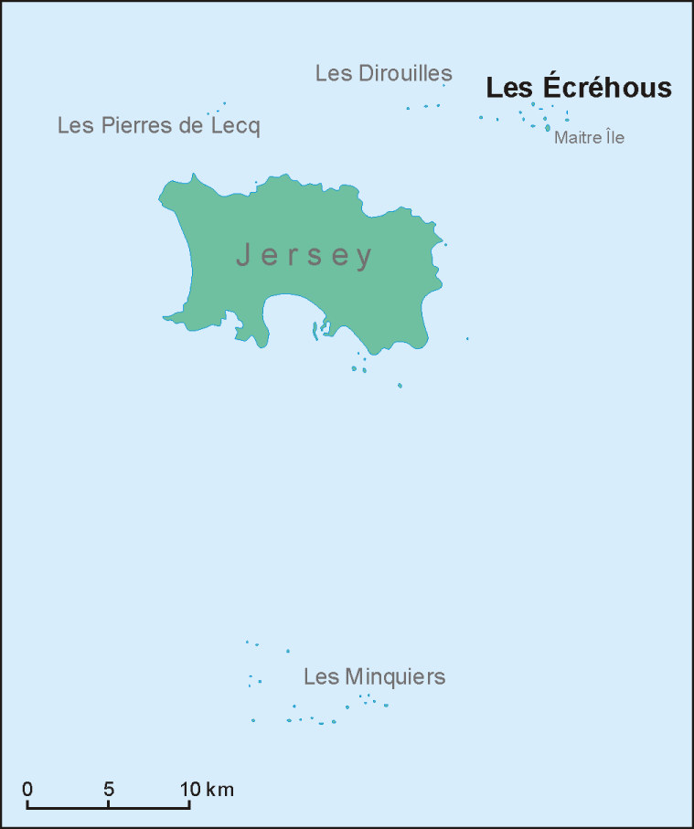
The ÃcrÃĐhous (; or in JÃĻrriais: ''ÃcrÃĐho'') are a group of islands and rocks situated north-east of Jersey, and from France. They form part of the Bailiwick of Jersey and are administratively part of the Parish of St Martin. Etymology The name 'Ecrehous' is Norse in origin. "Esker" as in Skerry meaning a stony bank and ' Hou', the toponym found also in Jethou, Lihou, Brecqhou, Burhou and other islets, derives from ''holm'', meaning ''island''. The first part of the name appears to be traced back to the Norse word ''sker'', meaning ''reef''. The Ecrehous are actually, geologically, part of the same island group as Les Dirouilles (west) and Les Pierres de Lecq ('the Paternosters') (further west). Islets The most significant islets in the group are: *MaÃŪtr'Ãle *La MarmotchiÃĐthe ('La MarmotiÃĻre' in gallicized form) *LÃĐ Bliantch'Ãle (''La Blanche Ãle'' in gallicized form); others include: *Les D'mies *La Grand' Naithe *L'EtchiÃĻrviÃĐthe *LÃĐ Fou *La Froutchie Al ... [...More Info...] [...Related Items...] OR: [Wikipedia] [Google] [Baidu] |
-hou
''-hou'' or ''hou'' is a place-name element found commonly in the Norman toponymy of the Channel Islands and continental Normandy. Etymology and signification Its etymology and meaning are disputed, but most specialists think it comes from Saxon or Anglo-Saxon ''hÅh'' "heel", sometimes ''hÅ'', then "heel-shaped promontory", "rocky steep slope", "steep shore". This toponymic appellative appears as a final ''-hou'' or associated with the Romance definite article ''le Hou''. It can be found everywhere in Normandy, but more in the western part of it. The English toponymy uses this Saxon or Anglo-Saxon element the same way, but its result is phonetically ''-hoo'' or ''-hoe'', sometimes ''-(h)ow'' or ''-ho'' e. g. : Northoo (Suffolk); Poddinghoo (Worcestershire); Millhoo (Essex); Fingringhoe (Essex); Rainow (Cheshire); Soho (London); etc. Eilert Ekwall, ''The Concise Oxford Dictionary of English Place-names'' (4th edition), Oxford University Press, Oxford, 1960, p. 244b. As ... [...More Info...] [...Related Items...] OR: [Wikipedia] [Google] [Baidu] |
Jersey
Jersey ( ; ), officially the Bailiwick of Jersey, is an autonomous and self-governing island territory of the British Islands. Although as a British Crown Dependency it is not a sovereign state, it has its own distinguishing civil and government institutions, so qualifies as a small nation or island country. Located in Northwestern Europe, off the coast of north-west France, it is the largest of the Channel Islands and is from Normandy's Cotentin Peninsula. The Bailiwick consists of the main island of Jersey and some surrounding uninhabited islands and rocks including Les Dirouilles, Les ÃcrÃĐhous, Les Minquiers, and Les Pierres de Lecq. Jersey was part of the Duchy of Normandy, whose dukes became kings of England from 1066. After Normandy was lost by the kings of England in the 13th century, and the ducal title surrendered to France, Jersey remained loyal to the English Crown, though it never became part of the Kingdom of England. At the end of the Napoleonic ... [...More Info...] [...Related Items...] OR: [Wikipedia] [Google] [Baidu] |
Saint Martin, Jersey
St Martin (JÃĻrriais: ) is one of the twelve parishes of Jersey in the Channel Islands. It is north-east of St Helier. It has a population of 3,948.''Portrait of the Channel Islands'', Raoul LempriÃĻre, 1970 The parish covers . The parish is a mixed rural-urban community and forms the north-east corner of the Jersey rectangle. It has the easternmost point of the Bailiwick. Most of the population is concentrated in the villages of the parish and along La Grande Route de Faldouet and the coast towards St Catherine's. The village of Gorey is partly located in the parish, with the remainder of the village in Grouville. In Gorey, the parish hosts one of the three principal English military fortifications located in Jersey: Mont Orgeuil (Gorey) Castle. The village of Maufant is also partly located in St Martin, along the boundary with St Saviour. History Historically it was called (Saint Martin the Old) to distinguish it from (known today as Grouville). This explains why the p ... [...More Info...] [...Related Items...] OR: [Wikipedia] [Google] [Baidu] |
Les Dirouilles
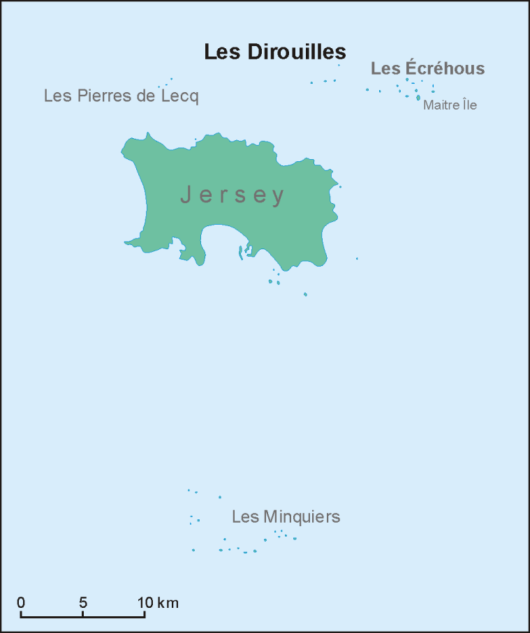
Les Dirouilles (; ) are a range of rocks to the North-East of Jersey Jersey ( ; ), officially the Bailiwick of Jersey, is an autonomous and self-governing island territory of the British Islands. Although as a British Crown Dependency it is not a sovereign state, it has its own distinguishing civil and gov .... Historically and administratively, they belong to the parish of Saint Martin. They have a large range of names, taken individually, and are also known as just ''Les PiÃĻrres'' (the rocks).R RamsarLesEcrehousManagementPlan (size 1Mb) DM 02022012.pdf References External linksLes DithouÃŊl'yes with lists of names Dirouilles Dirouilles Wetlands of the Channel Islands {{Jersey-geo-stub ... [...More Info...] [...Related Items...] OR: [Wikipedia] [Google] [Baidu] |
Bailiwick
A bailiwick () is usually the area of jurisdiction of a bailiff, and once also applied to territories in which a privately appointed bailiff exercised the sheriff's functions under a royal or imperial writ. In English, the original French combined with , the Anglo-Saxon suffix (meaning a village) to produce a term meaning literally 'bailiff's village'âthe original geographic scope of a bailiwick. In the 19th century, it was absorbed into American English as a metaphor for a sphere of knowledge or activity. The term can also be used colloquially to mean 'one's area of expertise.' The term survives in administrative usage in the British Crown Dependencies of the Channel Islands, which are grouped for administrative purposes into two bailiwicksthe Bailiwick of Jersey (comprising the island of Jersey and uninhabited islets such as the Minquiers and ÃcrÃĐhous) and the Bailiwick of Guernsey (comprising the islands of Guernsey, Sark, Alderney, Brecqhou, Herm, Jethou and L ... [...More Info...] [...Related Items...] OR: [Wikipedia] [Google] [Baidu] |
Islet
An islet ( ) is generally a small island. Definitions vary, and are not precise, but some suggest that an islet is a very small, often unnamed, island with little or no vegetation to support human habitation. It may be made of rock, sand and/or hard coral; may be permanent or tidal (i.e. surfaced reef or seamount); and may exist in the sea, lakes, rivers or any other sizeable bodies of water. Definition As suggested by its origin ''islette'', an Old French diminutive of "isle", use of the term implies small size, but little attention is given to drawing an upper limit on its applicability. The World Landforms website says, "An islet landform is generally considered to be a rock or small island that has little vegetation and cannot sustain human habitation", and further that size may vary from a few square feet to several square miles, with no specific rule pertaining to size. Other terms * Ait (/eÉŠt/, like eight) or eyot (/aÉŠ(É)t, eÉŠt/), a small island. It is espe ... [...More Info...] [...Related Items...] OR: [Wikipedia] [Google] [Baidu] |
Cotentin Peninsula
The Cotentin Peninsula (, ; ), also known as the Cherbourg Peninsula, is a peninsula in Normandy that forms part of the northwest coast of France. It extends north-westward into the English Channel, towards Great Britain. To its west lie the Gulf of Saint-Malo and the Channel Islands, and to the southwest lies the peninsula of Brittany. The peninsula lies wholly within the department of Manche, in the region of Normandy. Geography The Cotentin peninsula is part of the Armorican Massif (with the exception of the Plain lying in the Paris Basin) and lies between the estuary of the Vire river and Mont Saint-Michel Bay. It is divided into three areas: the headland of Cap de la Hague, the Cotentin Pass (the Plain), and the valley of the Saire River ( Val de Saire). It forms the bulk of the department of Manche. Its southern part, known as "le Marais" (the Marshlands), crosses from east to west from just north west of Saint Lo and east of Lessay and marks a natural border with t ... [...More Info...] [...Related Items...] OR: [Wikipedia] [Google] [Baidu] |
French Language
French ( or ) is a Romance languages, Romance language of the Indo-European languages, Indo-European family. Like all other Romance languages, it descended from the Vulgar Latin of the Roman Empire. French evolved from Northern Old Gallo-Romance, a descendant of the Latin spoken in Northern Gaul. Its closest relatives are the other langues d'oÃŊlâlanguages historically spoken in northern France and in southern Belgium, which French (Francien language, Francien) largely supplanted. It was also substratum (linguistics), influenced by native Celtic languages of Northern Roman Gaul and by the Germanic languages, Germanic Frankish language of the post-Roman Franks, Frankish invaders. As a result of French and Belgian colonialism from the 16th century onward, it was introduced to new territories in the Americas, Africa, and Asia, and numerous French-based creole languages, most notably Haitian Creole, were established. A French-speaking person or nation may be referred to as Fra ... [...More Info...] [...Related Items...] OR: [Wikipedia] [Google] [Baidu] |
Tide
Tides are the rise and fall of sea levels caused by the combined effects of the gravitational forces exerted by the Moon (and to a much lesser extent, the Sun) and are also caused by the Earth and Moon orbiting one another. Tide tables can be used for any given locale to find the predicted times and amplitude (or " tidal range"). The predictions are influenced by many factors including the alignment of the Sun and Moon, the phase and amplitude of the tide (pattern of tides in the deep ocean), the amphidromic systems of the oceans, and the shape of the coastline and near-shore bathymetry (see '' Timing''). They are however only predictions, the actual time and height of the tide is affected by wind and atmospheric pressure. Many shorelines experience semi-diurnal tidesâtwo nearly equal high and low tides each day. Other locations have a diurnal tideâone high and low tide each day. A "mixed tide"âtwo uneven magnitude tides a dayâis a third regular category. ... [...More Info...] [...Related Items...] OR: [Wikipedia] [Google] [Baidu] |
English Channel
The English Channel, also known as the Channel, is an arm of the Atlantic Ocean that separates Southern England from northern France. It links to the southern part of the North Sea by the Strait of Dover at its northeastern end. It is the busiest Sea lane, shipping area in the world. It is about long and varies in width from at its widest to at its narrowest in the Strait of Dover."English Channel". ''The Columbia Encyclopedia'', 2004. It is the smallest of the shallow seas around the continental shelf of Europe, covering an area of some . The Channel aided the United Kingdom in becoming a naval superpower, serving as a natural defence against invasions, such as in the Napoleonic Wars and in the World War II, Second World War. The northern, English coast of the Channel is more populous than the southern, French coast. The major languages spoken in this region are English language, English and French language, French. Names Roman historiography, Roman sources as (or , ... [...More Info...] [...Related Items...] OR: [Wikipedia] [Google] [Baidu] |


