Cross Green, Leeds on:
[Wikipedia]
[Google]
[Amazon]
 Cross Green is a mainly industrial area of
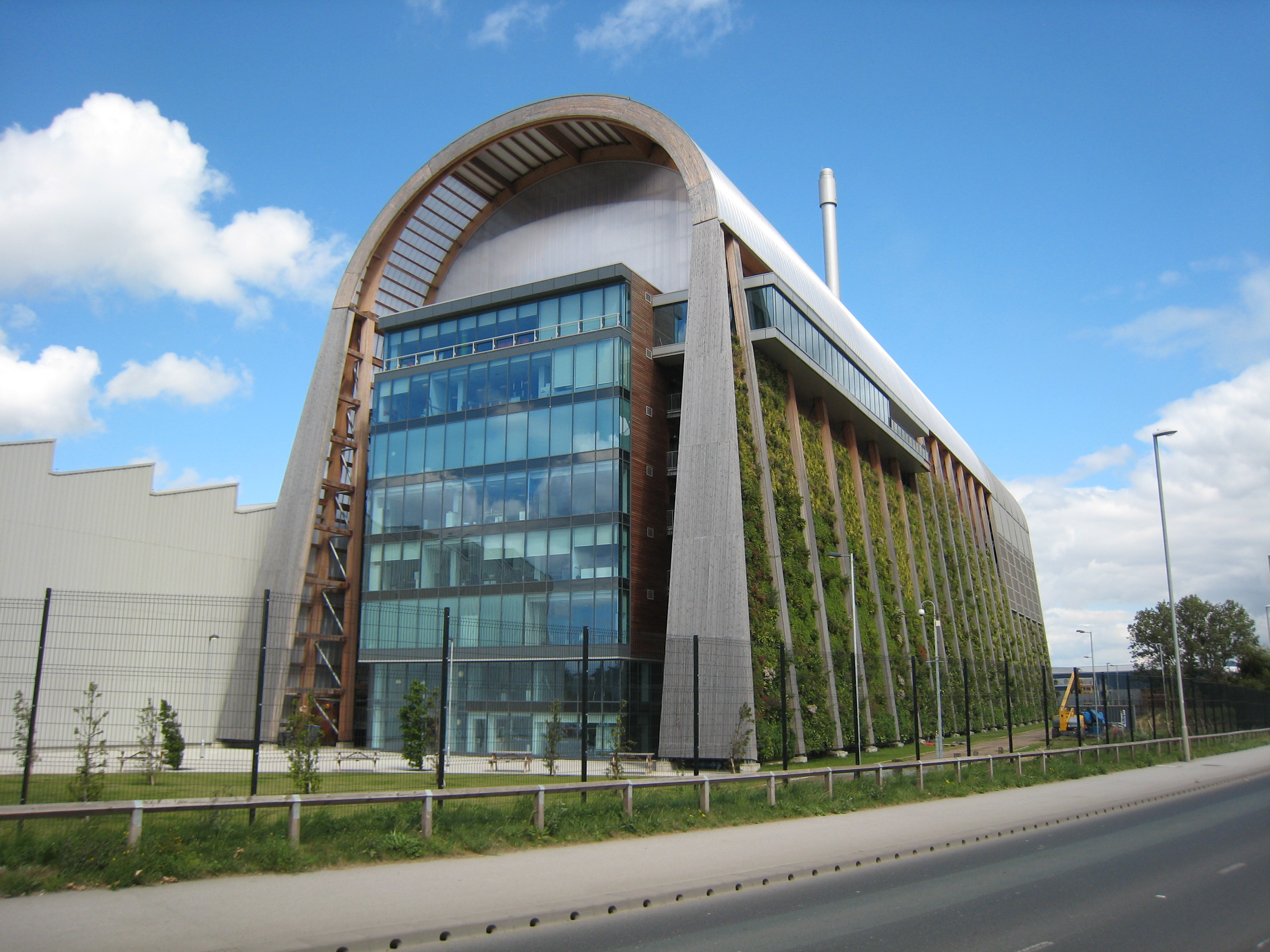
 An area north of Pontefract Lane formerly housed the main Leeds wholesale markets, one for meat, one for fish, fruit and vegetables. This was redeveloped into a facility for converting household waste into energy which opened in April 2016, and handles all the black bag bin waste from Leeds. This is called the Leeds Recycling and Energy Recovery Facility (RERF), and is operated by
File:Knowsthorpe Gate Roundabout sign 20 July 2017.jpg, Road from the industrial estate to the A63 roundabout
File:Cross Green Way and Vale 20 July 2017.jpg, Road on Cross Green Industrial Estate
File:St Hildas Place, Cross Green 5 Nov 2016.jpg, Terraced housing
File:Leeds GATE, Cross Green Lane 14 Sep 2013.jpg, Leeds GATE
File:St Hilda Cross Green 01 5 Nov 2016.jpg, St Hilda exterior
File:St Hilda Cross Green interior 2013.jpg, St Hilda interior
 Cross Green is a mainly industrial area of
 Leeds
Leeds () is a City status in the United Kingdom, city and the administrative centre of the City of Leeds district in West Yorkshire, England. It is built around the River Aire and is in the eastern foothills of the Pennines. It is also the thi ...
, West Yorkshire
West Yorkshire is a metropolitan and ceremonial county in the Yorkshire and Humber Region of England. It is an inland and upland county having eastward-draining valleys while taking in the moors of the Pennines. West Yorkshire came into exis ...
, England. It is around on a hill to the south east of Leeds city centre
Leeds city centre is the central business district of Leeds, West Yorkshire, England. It is roughly bounded by the Inner Ring Road to the north and the River Aire to the south and can be divided into several quarters.
Central districts
A ...
, with the A63 road
The A63 is a major road in Yorkshire, England between Leeds and Kingston upon Hull. A section between North Cave and Hull forms the eastward continuation of the M62 motorway and is part of the unsigned Euroroute E20.
Leeds – Howden
The ...
(Pontefract Lane) running through the middle and dividing it into a residential estate with playing fields and housing to the north, and a large industrial estate
An industrial park (also known as industrial estate, trading estate) is an area zoned and planned for the purpose of industrial development. An industrial park can be thought of as a more "heavyweight" version of a business park or office park, ...
to the south. The area lies in the LS9 Leeds postcode area between Osmondthorpe, Richmond Hill and Hunslet
Hunslet () is an inner-city area in south Leeds, West Yorkshire, England. It is southeast of the city centre and has an industrial past.
It is situated in the Hunslet and Riverside ward of Leeds City Council and Leeds Central parliamentary ...
.
Leeds RERF
 An area north of Pontefract Lane formerly housed the main Leeds wholesale markets, one for meat, one for fish, fruit and vegetables. This was redeveloped into a facility for converting household waste into energy which opened in April 2016, and handles all the black bag bin waste from Leeds. This is called the Leeds Recycling and Energy Recovery Facility (RERF), and is operated by
 Veolia
Veolia Environnement S.A., branded as Veolia, is a French transnational company with activities in three main service and utility areas traditionally managed by public authorities – water management, waste management and energy services. It p ...
. The main building itself is distinctive in appearance, because of its arched timber beam construction and a Green wall on the South side, and won the Project of the Year award at the Structural Timber Awards 2015.
Residential Area
This consists of 450 homes, largely traditional terraced and back-to-back houses on Cross Green Lane and streets north of it. It is home to Leeds GATE (Gypsy And Traveller Exchange). A school, Cross Green Comprehensive School, became Copperfields College, but has now been demolished. The Anglican Church of St Hilda and its vicarage are both Grade II Listed Buildings. It is a red brick church by J. T. Micklethwaite, dating from 1881.Notable people
It was the birthplace in 1942 of the poetBarry Tebb
Barry Tebb is an English poet, publisher and author. He was born in Leeds, West Riding of Yorkshire in 1942.
Early career
Tebb studied English at the Leeds Training College 1961-1964 and while there ... "read widely, Proust, Firbank, Dickens, Gi ...
.
See also
* Listed buildings in Leeds (Burmantofts and Richmond Hill Ward)References
Places in Leeds {{WestYorkshire-geo-stub