Achtermannshöhe on:
[Wikipedia]
[Google]
[Amazon]
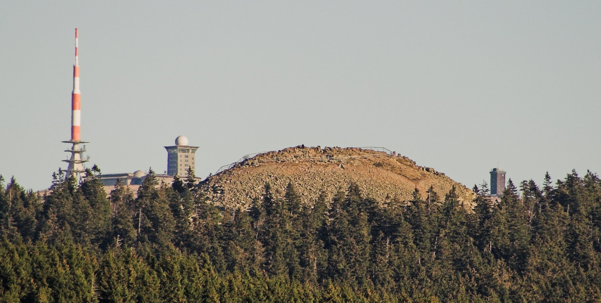
At , the Achtermannshöhe (also just called the Achtermann) in the

Harz National Park
Harz National Park is a nature reserve in the German federal states of Lower Saxony and Saxony-Anhalt. It comprises portions of the western Harz mountain range, extending from Herzberg and Bad Lauterberg at the southern edge to Bad Harzburg ...
is the third highest mountain
A mountain is an elevated portion of the Earth's crust, generally with steep sides that show significant exposed bedrock. Although definitions vary, a mountain may differ from a plateau in having a limited summit area, and is usually higher t ...
in Lower Saxony
Lower Saxony (german: Niedersachsen ; nds, Neddersassen; stq, Läichsaksen) is a German state (') in northwestern Germany. It is the second-largest state by land area, with , and fourth-largest in population (8 million in 2021) among the 16 ...
and the fourth highest in the Harz mountains
The Harz () is a highland area in northern Germany. It has the highest elevations for that region, and its rugged terrain extends across parts of Lower Saxony, Saxony-Anhalt, and Thuringia. The name ''Harz'' derives from the Middle High German w ...
.
It lies in the unparished area
In England, an unparished area is an area that is not covered by a civil parish (the lowest level of local government, not to be confused with an ecclesiastical parish). Most urbanised districts of England are either entirely or partly unparis ...
of Harz
The Harz () is a highland area in northern Germany. It has the highest elevations for that region, and its rugged terrain extends across parts of Lower Saxony, Saxony-Anhalt, and Thuringia. The name ''Harz'' derives from the Middle High German w ...
between the Harz-Heide route
The Harz-Heide Road is a road that runs over the Harz mountains in Germany through heath (German: ''Heide'') landscape and which is known for its scenery.
It runs from Göttingen along the Bundesstraße 27, B 27 and Bundesstraße 446, B 446 federa ...
( B 4) and the old Inner German Border
The inner German border (german: Innerdeutsche Grenze or ; initially also ) was the border between the German Democratic Republic (GDR, East Germany) and the West Germany, Federal Republic of Germany (FRG, West Germany) from 1949 to 1990. Not ...
about 6 km north of Braunlage
Braunlage () is a town and health resort in the Goslar district of Lower Saxony in Germany. Situated within the Harz mountain range, south of the Brocken massif, Braunlage's main business is tourism, particularly skiing. Nearby ski resorts includ ...
. Its summit, covered with loose boulders, stands proud of the surrounding trees and offers a superb all-round view. Equally its characteristic rounded hilltop or '' Kuppe'' is visible in good weather from many other points in the Harz.
The Achtermann may be accessed by paths leading from Oderbrück and Königskrug
Braunlage () is a town and health resort in the Goslar district of Lower Saxony in Germany. Situated within the Harz mountain range, south of the Brocken massif, Braunlage's main business is tourism, particularly skiing. Nearby ski resorts ...
.
Geology
The base of the Achtermannshöhe is part of thegranite
Granite () is a coarse-grained ( phaneritic) intrusive igneous rock composed mostly of quartz, alkali feldspar, and plagioclase. It forms from magma with a high content of silica and alkali metal oxides that slowly cools and solidifies und ...
massif of the Brocken
The Brocken, also sometimes referred to as the Blocksberg, is the highest peak in the Harz mountain range and also the highest peak in Northern Germany; it is near Schierke in the German state of Saxony-Anhalt between the rivers Weser and Elb ...
, which extends across a wide area between Wurmberg
Wurmberg is a municipality in the district of Enz in Baden-Württemberg in Germany.
Geography
Wurmberg is located on the so-called Platte, a Karst mountain range in the northern Black Forest (Schwarzwald).
Municipality
The municipality ...
, Torfhaus and Elend. By contrast, the rocky, treeless ''Kuppe'' of the Achtermann comprises hornfels
Hornfels is the group name for a set of contact metamorphic rocks that have been baked and hardened by the heat of intrusive igneous masses and have been rendered massive, hard, splintery, and in some cases exceedingly tough and durable. These pr ...
, a contact metamorphic rock. The hornstone on the summit has a depth of about
10 m and was formed from Grauwacke
Greywacke or graywacke ( German ''grauwacke'', signifying a grey, earthy rock) is a variety of sandstone generally characterized by its hardness, dark color, and poorly sorted angular grains of quartz, feldspar, and small rock fragments or ...
as it was heated during the intrusion of granitic magma
Magma () is the molten or semi-molten natural material from which all igneous rocks are formed. Magma is found beneath the surface of the Earth, and evidence of magmatism has also been discovered on other terrestrial planets and some natura ...
.

History
Earlier names include ''Uchteneshoge'' and ''Uchtenhoch''.Hiking
The Achtermannshöhe is checkpoint no. 12 in the network of ‘stamp’ checkpoints on the Harz Wandernadel route.See also
*List of mountains and hills of Lower Saxony
This List of mountains and hills in Lower Saxony shows a selection of high or well-known mountains and hills in the German state of Lower Saxony (''in order of height''). Although there is no universally agreed definition of a ' mountain', summ ...
* List of mountains of the Harz
References
{{DEFAULTSORT:Achtermannshohe Mountains of Lower Saxony Mountains of the Harz Braunlage Mountains under 1000 metres