|
West Greenland Current
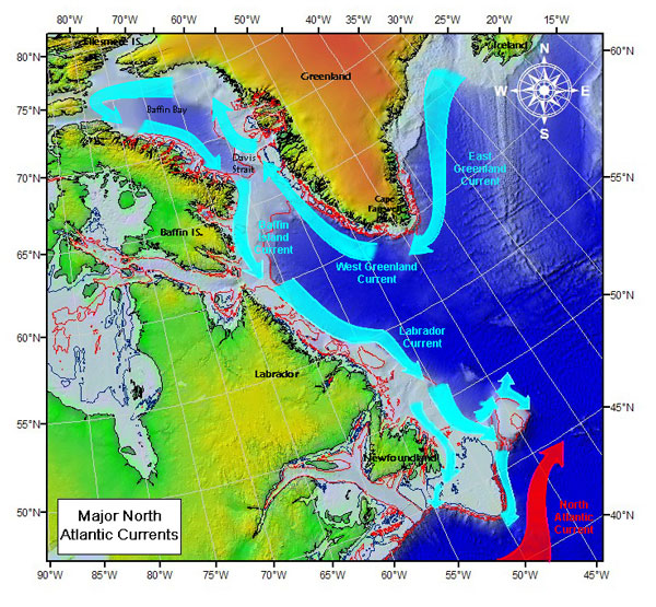
The West Greenland Current is a weak cold water current that flows to the north along the west coast of Greenland. The current results from the movement of water flowing around the southernmost point of Greenland caused by the East Greenland Current. According to Lloyd et al., 2007, the WGC is a WARM current connected to a broader scale North Atlantic climate via the combined influences of Atlantic water from the Irminger Current (IC) and polar water from the East Greenland Current. Paleoclimatology records derived from foraminifera abundance show that periodic influxes of warm subsurface temperatures and near-bottom temperatures occurred throughout the Late Holocene epoch, particularly during the Holocene climatic optimum. The increased flow from the nearby East Greenland Current was associated with increased glacial iceberg calving from the large Jakobshavn Isbrae glacial outlet within the western Greenland Ice Sheet, causing rapid melting and destabilization events. Follo ... [...More Info...] [...Related Items...] OR: [Wikipedia] [Google] [Baidu] |
Jakobshavn Isbrae
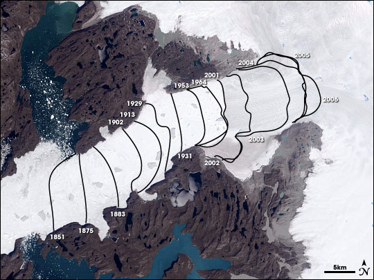
Jakobshavn Glacier ( da, Jakobshavn Isbræ), also known as Ilulissat Glacier ( kl, Sermeq Kujalleq), is a large outlet glacier in West Greenland. It is located near the Greenlandic town of Ilulissat (colonial name in da, Jakobshavn) and ends at the sea in the Ilulissat Icefjord. Jakobshavn Glacier drains 6.5% of the Greenland ice sheet and produces around 10% of all Greenland icebergs. Some 35 billion tonnes of icebergs calve off and pass out of the fjord every year. Icebergs breaking from the glacier are often so large (up to 1 km in height) that they are too tall to float down the fjord and lie stuck on the bottom of its shallower areas, sometimes for years, until they are broken up by the force of the glacier and icebergs further up the fjord. Studied for over 250 years, the Jakobshavn Glacier has helped develop modern understanding of climate change and icecap glaciology. Ilulissat Icefjord ( kl, Ilulissat Kangerlua) was declared a UNESCO World Heritage Site in 2004, ... [...More Info...] [...Related Items...] OR: [Wikipedia] [Google] [Baidu] |
Currents Of The Atlantic Ocean
Currents, Current or The Current may refer to: Science and technology * Current (fluid), the flow of a liquid or a gas ** Air current, a flow of air ** Ocean current, a current in the ocean *** Rip current, a kind of water current ** Current (stream), currents in rivers and streams ** Convection current, flow caused by unstable density variation due to temperature differences * Current (mathematics), geometrical current in differential topology * Conserved current, a field associated to a symmetry in field theory * Electric current, a flow of electric charge through a medium * Probability current, in quantum mechanics * IBM Current, an early personal information management program Arts and entertainment Music * ''Current'' (album), a 1982 album by Heatwave * ''Currents'' (Eisley album) * ''Currents'' (Tame Impala album) * "The Current" (song), by the Blue Man Group * "Currents", a song by Dashboard Confessional from ''Dusk and Summer'', 2006 * "Currents", a song by Drake from ... [...More Info...] [...Related Items...] OR: [Wikipedia] [Google] [Baidu] |
Physical Oceanography
Physical oceanography is the study of physical conditions and physical processes within the ocean, especially the motions and physical properties of ocean waters. Physical oceanography is one of several sub-domains into which oceanography is divided. Others include biological, chemical and geological oceanography. Physical oceanography may be subdivided into ''descriptive'' and ''dynamical'' physical oceanography. Descriptive physical oceanography seeks to research the ocean through observations and complex numerical models, which describe the fluid motions as precisely as possible. Dynamical physical oceanography focuses primarily upon the processes that govern the motion of fluids with emphasis upon theoretical research and numerical models. These are part of the large field of Geophysical Fluid Dynamics (GFD) that is shared together with meteorology. GFD is a sub field of Fluid dynamics describing flows occurring on spatial and temporal scales that are greatly influenced ... [...More Info...] [...Related Items...] OR: [Wikipedia] [Google] [Baidu] |
Oceanic Gyres
In oceanography, a gyre () is any large system of circulating ocean currents, particularly those involved with large wind movements. Gyres are caused by the Coriolis effect; planetary vorticity, horizontal friction and vertical friction determine the circulatory patterns from the ''wind stress curl'' (torque). ''Gyre'' can refer to any type of vortex in an atmosphere or a sea, even one that is human-created, but it is most commonly used in terrestrial oceanography to refer to the major ocean systems. Major gyres The following are the five most notable ocean gyres:The five most notable gyres PowerPoint Presentation * * |
Gulf Stream
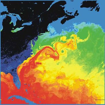
The Gulf Stream, together with its northern extension the North Atlantic Current, North Atlantic Drift, is a warm and swift Atlantic Ocean, Atlantic ocean current that originates in the Gulf of Mexico and flows through the Straits of Florida and up the eastern coastline of the United States then veers east near 36 latitude (North Carolina) and moves toward Northwest Europe as the North Atlantic Current. The process of Boundary current, western intensification causes the Gulf Stream to be a northwards accelerating current off the east coast of North America. At about , it splits in two, with the northern stream, the North Atlantic Drift, crossing to Northern Europe and the southern stream, the Canary Current, recirculating off West Africa. The Gulf Stream influences the climate of the coastal areas of the east coast of the United States from Florida to southeast Virginia (near 36 north latitude), and to a greater degree the climate of Northwest Europe. There is consensus that t ... [...More Info...] [...Related Items...] OR: [Wikipedia] [Google] [Baidu] |
Baffin Island Current
Baffin Island Current (or Baffin Current) is an ocean current running south down the western side of Baffin Bay in the Arctic Ocean, along Baffin Island. Its sources are the West Greenland Current and outflow from the Arctic Ocean. Its speed is approximately per day. References See also * Labrador Current * East Greenland Current The East Greenland Current (EGC) is a cold, low- salinity current that extends from Fram Strait (~80N) to Cape Farewell (~60N). The current is located off the eastern coast of Greenland along the Greenland continental margin. The current cuts t ... Baffin Bay Baffin Island Currents of the Arctic Ocean {{Marine-current-stub ... [...More Info...] [...Related Items...] OR: [Wikipedia] [Google] [Baidu] |
Labrador Current
The Labrador Current is a cold current in the North Atlantic Ocean which flows from the Arctic Ocean south along the coast of Labrador and passes around Newfoundland, continuing south along the east coast of Canada near Nova Scotia. Near Nova Scotia, this cold water current meets the warm northward moving Gulf Stream. The combination of these two currents produces heavy fogs and has also created one of the richest fishing grounds in the world. In spring and early summer, the Labrador Current transports icebergs from the glaciers of Greenland southwards into the trans-Atlantic shipping lanes. The waters of the current have a cooling effect on the Canadian Atlantic provinces, and on the United States' upper northeast coast from Maine south to Massachusetts. South of Cape Cod, Massachusetts, the Gulf Stream becomes the dominant ocean current. Iceberg transport The Labrador Current has a tendency to sometimes go farther south and/or east than normal. This can produce hazardous sh ... [...More Info...] [...Related Items...] OR: [Wikipedia] [Google] [Baidu] |
Ice Tongue
An ice tongue is a long and narrow sheet of ice projecting out from the coastline. An ice tongue forms when a valley glacier moves very rapidly (relative to surrounding ice) out into the ocean or a lake. They can gain mass from water freezing at their base, or by snow falling on top of them. Mass is then lost by calving or by melting. Ice tongues can range in length from to . Icebergs are often formed when ice tongues break off in part or wholly from the main glacier. Two examples of ice tongues are the Erebus Ice Tongue and the Drygalski Ice Tongue The Drygalski Ice Tongue, Drygalski Barrier, or Drygalski Glacier Tongue is a glacier in Antarctica, on the Scott Coast, in the northern McMurdo Sound of Ross Dependency, north of Ross Island. The Drygalski Ice Tongue is stable by the standar .... References * Bodies of ice Glaciers {{glaciology-stub ... [...More Info...] [...Related Items...] OR: [Wikipedia] [Google] [Baidu] |
Neoglaciation
The neoglaciation ("renewed glaciation") describes the documented cooling trend in the Earth's climate during the Holocene, following the retreat of the Wisconsin glaciation, the most recent glacial period. Neoglaciation has followed the hypsithermal or Holocene Climatic Optimum, the warmest point in the Earth's climate during the current interglacial stage, excluding the global warming-induced temperature increase starting in the 20th century. The neoglaciation has no well-marked universal beginning: local conditions and ecological inertia affected the onset of detectably cooler (and wetter) conditions. Driven inexorably by the Milankovitch cycle, cooler summers in higher latitudes of North America, which would cease to completely melt the annual snowfall, were masked at first by the presence of the slowly disappearing continental ice sheets, which persisted long after the astronomically calculated moment of maximum summer warmth: "the neoglaciation can be said to have begun wh ... [...More Info...] [...Related Items...] OR: [Wikipedia] [Google] [Baidu] |
Greenland Ice Sheet
The Greenland ice sheet ( da, Grønlands indlandsis, kl, Sermersuaq) is a vast body of ice covering , roughly near 80% of the surface of Greenland. It is sometimes referred to as an ice cap, or under the term ''inland ice'', or its Danish equivalent, ''indlandsis''. An acronym, GIS, is frequently used in the scientific literature. It is the second largest ice body in the world, after the Antarctic ice sheet. The ice sheet is almost long in a north–south direction, and its greatest width is at a latitude of 77°N, near its northern margin. The average thickness is about and over at its thickest point. In addition to the large ice sheet, smaller ice caps (such as Maniitsoq and Flade Isblink) as well as glaciers, cover between around the periphery. The Greenland ice sheet is adversely affected by climate change. It is more vulnerable to climate change than the Antarctic ice sheet because of its position in the Arctic, where it is subject to the regional amplification o ... [...More Info...] [...Related Items...] OR: [Wikipedia] [Google] [Baidu] |
Iceberg Calving
Ice calving, also known as glacier calving or iceberg calving, is the breaking of ice chunks from the edge of a glacier.Essentials of Geology, 3rd edition, Stephen Marshak It is a form of ice ablation or ice disruption. It is the sudden release and breaking away of a mass of ice from a glacier, iceberg, ice front, ice shelf, or crevasse. The ice that breaks away can be classified as an iceberg, but may also be a growler, bergy bit, or a crevasse wall breakaway.Glossary of Glacier Terms Ellin Beltz, 2006. Retrieved July 2009. Calving of glaciers is often accompanied by a loud cracking or booming sound before blocks of ice up to high break loose and crash into the water. The entry of the ice into the water causes large, and often hazardous waves. The waves formed in locations like |


