|
Woodburn, Oregon
Woodburn is a city in Marion County, Oregon, United States. Incorporated in 1889, the community had been platted in 1871 after the arrival of the railroad. The city is located in the northern end of the Willamette Valley between Portland, Oregon, Portland and Salem, Oregon, Salem. Interstate 5 in Oregon, Interstate 5 connects it to major cities to the north and south. Oregon routes Oregon Route 211, 211, Oregon Route 214, 214, Oregon Route 219, 219, and Oregon Route 99E, 99E also serve the city, as do Union Pacific and Willamette Valley Railway freight rail lines. Woodburn is part of the Salem Metropolitan Statistical Area. With a population of 26,013 at the 2020 United States census, 2020 census, it is the third-most populous in that metropolitan area after Salem and Keizer, Oregon, Keizer. History Originally, the area around Woodburn was inhabited by the Kalapuya Native Americans. After the Provisional Government of Oregon set-up land claims in the Oregon Country, the United S ... [...More Info...] [...Related Items...] OR: [Wikipedia] [Google] [Baidu] |
City
A city is a human settlement of a substantial size. The term "city" has different meanings around the world and in some places the settlement can be very small. Even where the term is limited to larger settlements, there is no universally agreed definition of the lower boundary for their size. In a narrower sense, a city can be defined as a permanent and Urban density, densely populated place with administratively defined boundaries whose members work primarily on non-agricultural tasks. Cities generally have extensive systems for housing, transportation, sanitation, Public utilities, utilities, land use, Manufacturing, production of goods, and communication. Their density facilitates interaction between people, government organisations, government organizations, and businesses, sometimes benefiting different parties in the process, such as improving the efficiency of goods and service distribution. Historically, city dwellers have been a small proportion of humanity overall, bu ... [...More Info...] [...Related Items...] OR: [Wikipedia] [Google] [Baidu] |
Oregon Route 211
Oregon Route 211 is a state highway which runs through part of the northeastern portion of Oregon's Willamette Valley. Its northeastern terminus is its intersection with U.S. Route 26 in Sandy, a small town on the outskirts of the Portland metro area. It runs south and west, through farmland and forest, to its southwestern terminus with OR 99E in Woodburn. After its intersection with OR 99E, a short segment (about ) of Oregon Route 214 connects OR 211 with Interstate 5. A segment (about ) of OR 211 north of Estacada is shared with OR 224. OR 211 comprises the Eagle Creek-Sandy Highway No. 172 (see Oregon highways and routes), part of the Clackamas Highway No. 171 (over the concurrency with OR 224), and the Woodburn-Estacada Highway No. 161. Major intersections References {{Reflist 211 Year 211 ( CCXI) was a common year starting on Tuesday of the Julian calendar. At the time, in the Roman Empire it was known as the Year of the Consulship of Terenti ... [...More Info...] [...Related Items...] OR: [Wikipedia] [Google] [Baidu] |
Donation Land Claim Act
The Donation Land Claim Act of 1850, sometimes known as the Donation Land Act, was a statute enacted by the United States Congress in late 1850, intended to promote homestead settlements in the Oregon Territory. It followed the Distribution-Preemption Act 1841. The law, a forerunner of the later Homestead Act, brought thousands of settlers into the new territory, swelling their ranks along the Oregon Trail. 7,437 land patents were issued under the law, which expired in late 1855. The Donation Land Claim Act allowed white men or partial Native Americans (mixed with white) who had arrived in Oregon before 1850 to work on a piece of land for four years and legally claim the land for themselves. Along with other US land grant legislation, the Donation Land Claim Act discriminated against nonwhite settlers and had the effect of dispossessing land from Native Americans. History The passage of the law was largely due to the efforts of Samuel R. Thurston, the Oregon territorial del ... [...More Info...] [...Related Items...] OR: [Wikipedia] [Google] [Baidu] |
Oregon Territory
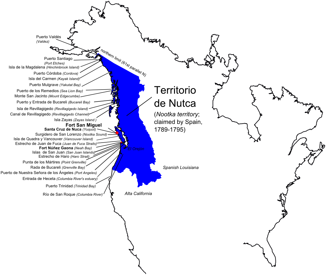
The Territory of Oregon was an organized incorporated territory of the United States that existed from August 14, 1848, until February 14, 1859, when the southwestern portion of the territory was admitted to the United States, Union as the Oregon, State of Oregon. Originally claimed by several countries (see Oregon Country), Spanish "El Orejón" was part of the Territorio de Nutca (1789–1795), later in the 19th century, the region was divided between the British North America, British Empire and the US in 1846. When established, the territory encompassed an area that included the current states of Oregon, Washington (state), Washington, and Idaho, as well as parts of Wyoming and Montana. The capital of the territory was first Oregon City, Oregon, Oregon City, then Salem, Oregon, Salem, followed briefly by Corvallis, Oregon, Corvallis, then back to Salem, which became the state capital upon Oregon's admission to the Union. Background Originally inhabited by Native Americans, ... [...More Info...] [...Related Items...] OR: [Wikipedia] [Google] [Baidu] |
Oregon Country
Oregon Country was a large region of the Pacific Northwest of North America that was subject to a long Oregon boundary dispute, dispute between the United Kingdom and the United States in the early 19th century. The area, which had been demarcated by the Treaty of 1818, consisted of the land north of 42nd parallel north, 42° N latitude, south of 54°40′ N latitude, and west of the Rocky Mountains down to the Pacific Ocean and east to the Continental Divide of the Americas, Continental Divide. Article III of the 1818 treaty gave joint control to both nations for ten years, allowed land to be claimed, and guaranteed free navigation to all mercantile trade. However, both countries disputed the terms of the international treaty. Oregon Country was the American name, while the British used Columbia District for the British Empire, region. British North America, British and French Canadians, French History of Canada (1763–1867), Canadian North American fur trade, fur tr ... [...More Info...] [...Related Items...] OR: [Wikipedia] [Google] [Baidu] |
Provisional Government Of Oregon
The Provisional Government of Oregon was a popularly elected settler government created in the Oregon Country (1818-1846), in the Pacific Northwest region of the western portion of the continent of North America. Its formation had been advanced at the Champoeg Meetings since February 17, 1841, and it existed from May 2, 1843 until March 3, 1849, and provided a legal system and a common defense amongst the mostly American pioneers settling an area then inhabited by the many Indigenous Nations. Much of the region's geography and many of the Natives were not known by people of European descent until several exploratory tours and expeditions were authorized at the turn of the 18th to the 19th centuries, such as Lewis and Clark's Corps of Discovery going northwest in 1804-1806, and United States Army Lt. Zebulon Pike and his party first journeying north, then later to the far southwest. The Organic Laws of Oregon were adopted in 1843 with its preamble stating that settlers onl ... [...More Info...] [...Related Items...] OR: [Wikipedia] [Google] [Baidu] |
Kalapuya
The Kalapuya are a Native American people, which had eight independent groups speaking three mutually intelligible dialects. The Kalapuya tribes' traditional homelands were the Willamette Valley of present-day western Oregon in the United States, an area bounded by the Cascade Range to the east, the Oregon Coast Range at the west, the Columbia River at the north, to the Calapooya Mountains of the Umpqua River at the south. Today, most Kalapuya people are enrolled in the federally recognized Confederated Tribes of the Grand Ronde Community of Oregon; in addition, some are members of the Confederated Tribes of the Siletz. In both cases descendants have often intermarried with people of other tribes in the confederated tribes, and are counted in overall tribal numbers, rather than separately. Most of the Kalapuya descendants live at the Grand Ronde reservation, located in Yamhill and Polk counties. Name The tribal name has been rendered into English under various spellings as ... [...More Info...] [...Related Items...] OR: [Wikipedia] [Google] [Baidu] |
Keizer, Oregon
Keizer () is a city located in Marion County, Oregon, United States, along the 45th parallel north, 45th parallel. As of the 2020 United States census, its population was 39,376, making it the List of cities in Oregon, 14th most populous city in Oregon. It lies in the Willamette Valley, and is part of the Salem Metropolitan Statistical Area. It was named after pioneer Thomas Dove (T. D.) Keizur and his family, who arrived in the Wagon Train of 1843, and later filed Donation Land Claim Act of 1850, donation land claims. History The original settlement was at Keizer Bottom, near the banks of the Willamette River. The community was named after Thomas Dove Keizur, one of its first settlers. Somewhere in the translation of donation land claim records, his name was misspelled. The settlement suffered in the Great Flood of 1862, flood of 1861, and the inhabitants rebuilt their homes on higher ground. Further floods in 1943, 1945, 1946 and 1948 Columbia River flood, 1948 hampered the grow ... [...More Info...] [...Related Items...] OR: [Wikipedia] [Google] [Baidu] |
Salem Metropolitan Statistical Area
The Salem metropolitan statistical area, as defined by the United States Census Bureau, is a metropolitan statistical area consisting of two counties in western Oregon, Marion and Polk. The principal city is Salem, the state capital, which has a population of 175,535. The Salem MSA had a population of 433,353 at the 2020 census. In 2010, there were 390,738 people living in the Salem MSA. In 2000, the MSA had a population of 347,214, and had a population of 278,024 according to the 1990 census. Counties * Marion * Polk Communities Places with more than 125,000 inhabitants * Salem, 175,535 (principal city) Places with 10,000 to 40,000 inhabitants *Dallas, 16,854 *Four Corners, 16,740 (census-designated place) * Hayesville, 21,891 (census-designated place) * Keizer, 39,376 * Woodburn, 26,013 *Monmouth, 11,110 * Silverton, 10,484 Places with 1,000 to 10,000 inhabitants * Aumsville *Aurora *Donald * Falls City * Gervais * Grand Ronde (census-designated place) * Hubbard *Independe ... [...More Info...] [...Related Items...] OR: [Wikipedia] [Google] [Baidu] |
Willamette Valley Railway
The Willamette Valley Railway (reporting marks WVR, WGR) is a short-line railroad that operates in the Willamette Valley of Oregon. It leased a line from Woodburn to Stayton from the Southern Pacific Transportation Company in February 1993, as well as a branch from Geer west to Salem (partly abandoned in 1995), and purchased the property in 1996. The company also leased a line between Albany and Mill City in 1993, but transferred the lease to the Albany and Eastern Railroad in October 2000. November 16, 2007Edward A. Lewis, American Shortline Railway Guide, 5th Edition, |
Union Pacific
The Union Pacific Railroad is a Class I freight-hauling railroad that operates 8,300 locomotives over routes in 23 U.S. states west of Chicago and New Orleans. Union Pacific is the second largest railroad in the United States after BNSF, with which it shares a duopoly on transcontinental freight rail lines in the Western, Midwestern and West South Central United States. Founded in 1862, the original Union Pacific Rail Road was part of the first transcontinental railroad project, later known as the Overland Route. Over the next century, UP absorbed the Missouri Pacific Railroad, the Western Pacific Railroad, the Missouri–Kansas–Texas Railroad and the Chicago, Rock Island and Pacific Railroad. In 1995, the Union Pacific merged with Chicago and North Western Transportation Company, completing its reach into the Upper Midwest. In 1996, the company merged with Southern Pacific Transportation Company, itself a giant system that was absorbed by the Denver and Rio Gr ... [...More Info...] [...Related Items...] OR: [Wikipedia] [Google] [Baidu] |


