|
White Rock, British Columbia
White Rock is a city in British Columbia, Canada, and a member municipality of the Metro Vancouver Regional District. It is bordered by Semiahmoo Bay to the south and is surrounded on three sides by Surrey, British Columbia, Surrey. To the southeast across a footbridge lies the Semiahmoo First Nation, which is within the borders of Surrey. Semiahmoo Bay and the Southern Gulf Islands in the Strait of Georgia are also to the south. White Rock is named for a large white boulder on its beach near the promenade, a glacial erratic that migrated south during the last glaciation. The 486-ton granite boulder was kept white by shellfish-eating seabirds whose guano covered the rock so much that 19th-century sailors used it as a beacon. It is now kept white through monthly applications of white paint by the city parks department and has been a graffiti target. The White Rock Pier is located nearby. History Early history The Straits Salish, Straits Salish people dominated the region from ... [...More Info...] [...Related Items...] OR: [Wikipedia] [Google] [Baidu] |
Metro Vancouver
The Metro Vancouver Regional District (MVRD), or simply Metro Vancouver, is a Canadian political subdivision and Corporation, corporate entity representing the metropolitan area of Greater Vancouver, designated by provincial legislation as one of the 28 regional districts of British Columbia, regional districts in British Columbia. The organization was known as the Regional District of Fraser–Burrard for nearly one year upon incorporating in 1967, and as the Greater Vancouver Regional District (GVRD) from 1968 to 2017. Metro Vancouver borders Whatcom County, Washington, to the south, the Fraser Valley Regional District to the east, the Squamish-Lillooet Regional District to the north, and the Nanaimo Regional District and Cowichan Valley Regional District across the Strait of Georgia to the west. The MVRD is under the direction of 23 local authorities and delivers regional services, sets policy and acts as a political forum. The regional district's most populous city is Va ... [...More Info...] [...Related Items...] OR: [Wikipedia] [Google] [Baidu] |
Semiahmoo Bay
Semiahmoo Bay ( ) is the southeastern section of Boundary Bay on the Pacific coast of North America in British Columbia, Canada. The bay is named for the Semiahmoo First Nation, who originally occupied the area. The Semiahmoo Peninsula borders the bay and was home to cannery operations. It is now home to the Semiahmoo Golf Resort. From the north to south, the following communities and places are located on its shore: * North of the border, in British Columbia: ** the Crescent Beach and Ocean Park neighbourhoods of the city of Surrey ** the city of White Rock ** the Semiahmoo Indian Reserve of the Semiahmoo First Nation ** Peace Arch Provincial Park * South of the border, in Washington State: ** Peace Arch State Park Peace Arch Park is an international park consisting of Peace Arch Historical State Park in Washington, United States and Peace Arch Provincial Park in British Columbia, Canada. The park straddles the international boundary between the two count ... ** B ... [...More Info...] [...Related Items...] OR: [Wikipedia] [Google] [Baidu] |
Oregon Treaty
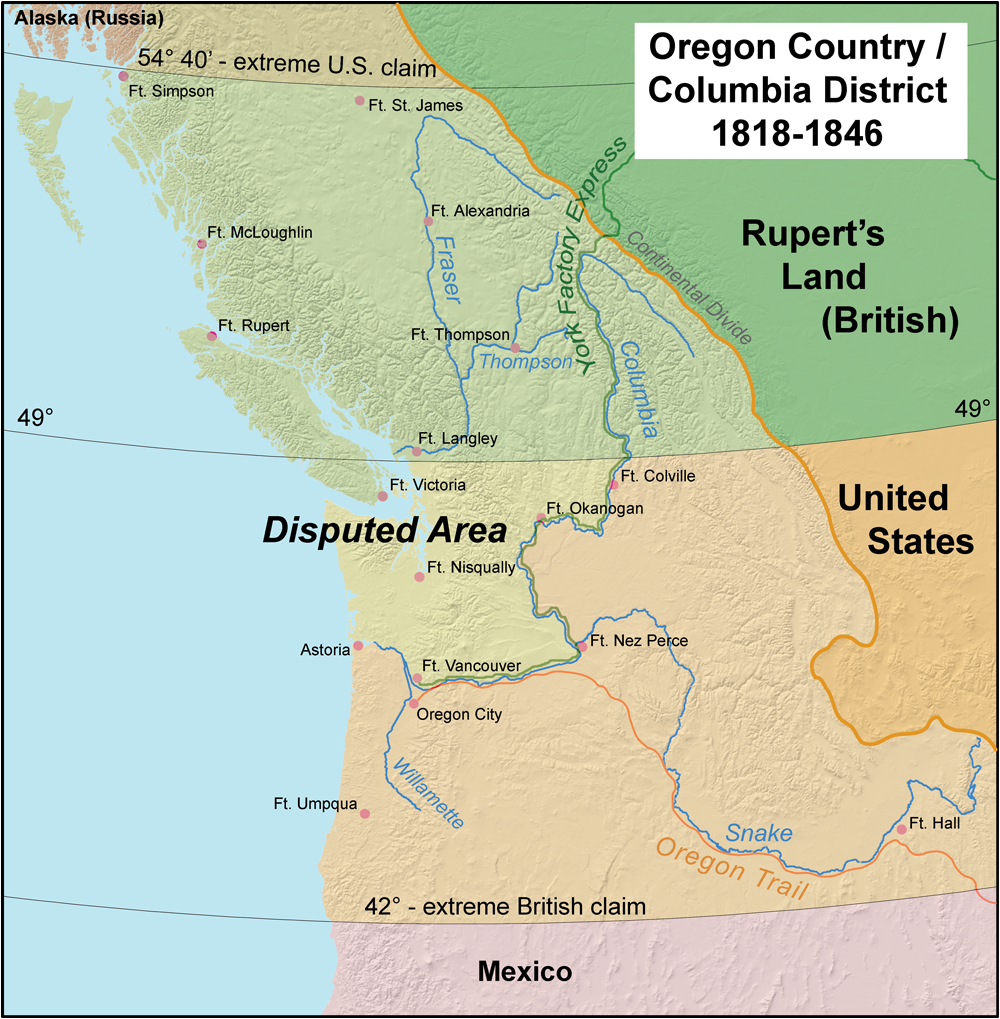
The Oregon Treaty was a treaty between the United Kingdom and the United States that was signed on June 15, 1846, in Washington, D.C. The treaty brought an end to the Oregon boundary dispute by settling competing American and British claims to the Oregon Country; the area had been Condominium (international law), jointly occupied by both Britain and the U.S. since the Treaty of 1818. Background The Treaty of 1818 set the boundary between the United States and British North America along the 49th parallel north, 49th parallel of north latitude from Minnesota to the "Stony Mountains" (now known as the Rocky Mountains). The region west of those mountains was known to the Americans as the Oregon Country and to the British as the Columbia Department or Columbia District of the Hudson's Bay Company. (Also included in the region was the southern portion of another fur district, New Caledonia (Canada), New Caledonia.) The treaty provided for joint control of that land for ten years. ... [...More Info...] [...Related Items...] OR: [Wikipedia] [Google] [Baidu] |
Oregon Boundary Dispute
The Oregon boundary dispute or the Oregon Question was a 19th-century territorial dispute over the political division of the Pacific Northwest of North America between several nations that had competing territorial and commercial aspirations in the region. Expansionist competition into the region began in the 18th century, with participants including the Russian Empire, Kingdom of Great Britain, Great Britain, Spain, and the United States. After the War of 1812, the Oregon dispute took on increased importance for diplomatic relations between the British Empire and the fledgling American republic. In the mid-1820s, the Russians signed the Russo-American Treaty of 1824 and the Russo-British Treaty of 1825, and the Spanish signed the Adams–Onís Treaty of 1819, by which Russia and Spain formally withdrew their respective territorial claims in the region, and the British and the Americans acquired residual territorial rights in the disputed area. But the question of sovereignty ov ... [...More Info...] [...Related Items...] OR: [Wikipedia] [Google] [Baidu] |
Boundary Bay
Boundary Bay is a shallow bay situated on the Pacific coast of North America on the Canada–United States border between the Canadian province of British Columbia and the U.S. state of Washington. Geography Boundary Bay is bounded to the east by the city of Blaine in Washington and the cities White Rock and Surrey in British Columbia. It is also bounded to the east by the reserves of the Semiahmoo First Nation in British Columbia. To the north, it is bounded by the City of Delta. To the west, it is bounded by the Tsawwassen Peninsula, which contains the communities of Tsawwassen (a suburb of Delta) and Point Roberts, Washington (a pene-exclave of the United States). To the south, it is bounded by the Strait of Georgia, the northern arm of the larger Salish Sea. The eastern section of Boundary Bay straddling the US/Canada border and adjacent to the cities of White Rock and Blaine is known as Semiahmoo Bay; Blaine's Drayton Harbor opens into it. The northern tip of Boundar ... [...More Info...] [...Related Items...] OR: [Wikipedia] [Google] [Baidu] |
Straits Salish
Northern Straits Salish (also referred to as North Straits Salish) is a language composed of several mutually-intelligible dialects within the Coast Salish language family spoken in western Washington and British Columbia. The various dialects of Northern Straits Salish are often referred to as separate languages, both in historic and modern times, and although their similarities are recognized by its speakers, there is no word for the language as a whole. Dialects The dialects of Northern Straits are as follows: (''†'') marks a dialect that has no native speakers. * Lummi () * Saanich (, ) * Samish () * Semiahmoo (''†'') * Songhees (; also known as Lekwungen or Songish) * T'sou-ke (also known as Sooke) Classification Northern Straits is a Salishan language within the Coast Salish branch. Among the Coast Salish languages, Northern Straits is one of the two languages in the Straits Salish branch, the other being Klallam. Klallam and Northern Straits are very closely re ... [...More Info...] [...Related Items...] OR: [Wikipedia] [Google] [Baidu] |
White Rock (2024)
White Rock or White Rocks may refer to: Places Australia * Wedding Cake Rock, New South Wales * White Rock Conservation Park, Queensland *Albino Rock, Queensland, an island formerly known as White Rock *White Rock River (New South Wales) * White Rock, Queensland (Cairns Region), a suburb in Cairns, Queensland * White Rock, Queensland (Ipswich), a suburb in the city of Ipswich, Queensland Canada *White Rock, British Columbia, Canada, a city * White Rock, Nova Scotia, Canada, an unincorporated community United States *White Rock, Franklin County, Arkansas, an unincorporated community * White Rock, Washington County, Arkansas, an unincorporated community * White Rock, California, an unincorporated community * White Rock, Illinois, an unincorporated community * White Rock, Kansas, a former settlement * White Rock, Michigan, an unincorporated community * White Rock, Minnesota, an unincorporated community *White Rock, Missouri, an unincorporated community * White Rock, Nevada, a ghost ... [...More Info...] [...Related Items...] OR: [Wikipedia] [Google] [Baidu] |
White Rock Pier
White Rock Pier is a pier in White Rock, British Columbia. The pier has a sign identifying it as Canada's longest pier. However, the title is disputed with the Quai de Portneuf in Portneuf, Quebec, which is built in the same manner as the longer causeway at the nearby Tsawwassen ferry terminal. History The original version of the pier was built in 1912 and resembled nothing more than a floating dock about 300 feet in length. It was destroyed by winter storms in 1913. In 1914 the pier was rebuilt with an eye to making it a dock for steamship A steamship, often referred to as a steamer, is a type of steam-powered vessel, typically ocean-faring and seaworthy, that is propelled by one or more steam engines that typically move (turn) propellers or paddlewheels. The first steamships ...s that arrived when the Great Northern Railway began operation. Although it was completed in August of that year, the onset of the First World War pushed the official opening back to Nove ... [...More Info...] [...Related Items...] OR: [Wikipedia] [Google] [Baidu] |
Guano
Guano (Spanish from ) is the accumulated excrement of seabirds or bats. Guano is a highly effective fertiliser due to the high content of nitrogen, phosphate, and potassium, all key nutrients essential for plant growth. Guano was also, to a lesser extent, sought for the production of gunpowder and other explosive materials. The 19th-century seabird guano trade played a pivotal role in the development of modern Intensive farming, input-intensive farming. The demand for guano spurred the human colonisation of remote bird islands in many parts of the world. Unsustainable seabird guano mining processes can result in permanent habitat destruction and the loss of millions of seabirds. Bat guano is found in caves throughout the world. Many cave ecosystems are wholly dependent on bats to provide nutrients via their guano which supports bacteria, Fungus, fungi, invertebrates, and vertebrates. The loss of bats from a cave can result in the extinction of species that rely on their guano ... [...More Info...] [...Related Items...] OR: [Wikipedia] [Google] [Baidu] |
Glacial Erratic
A glacial erratic is a glacially deposited rock (geology), rock differing from the type of country rock (geology), rock native to the area in which it rests. Erratics, which take their name from the Latin word ' ("to wander"), are carried by glacial ice, often over distances of hundreds of kilometres. Erratics can range in size from pebbles to large boulders such as Okotoks Erratic, Big Rock (16,500 metric tons) in Alberta. Geologists identify erratics by studying the rocks surrounding the position of the erratic and the composition of the erratic itself. Erratics are significant because: *They can be transported by glaciers, and are thereby one of a series of indicators which mark the path of prehistoric Glacial motion, glacier movement. Their lithographic origin can be traced to the parent bedrock, allowing for confirmation of the ice flow route. *They can be transported by ice rafting, which allows quantification of the extent of glacial flooding resulting from ice dam failure ... [...More Info...] [...Related Items...] OR: [Wikipedia] [Google] [Baidu] |
Strait Of Georgia
The Strait of Georgia () or the Georgia Strait is an arm of the Salish Sea between Vancouver Island and the extreme southwestern mainland coast of British Columbia, Canada, and the extreme northwestern mainland coast of Washington, United States. It is approximately long and varies in width from .Environmental History and Features of Puget Sound , NOAA-NWFSC Along with the and , it is a constituent part of the |


