|
Väinameri Conservation Area
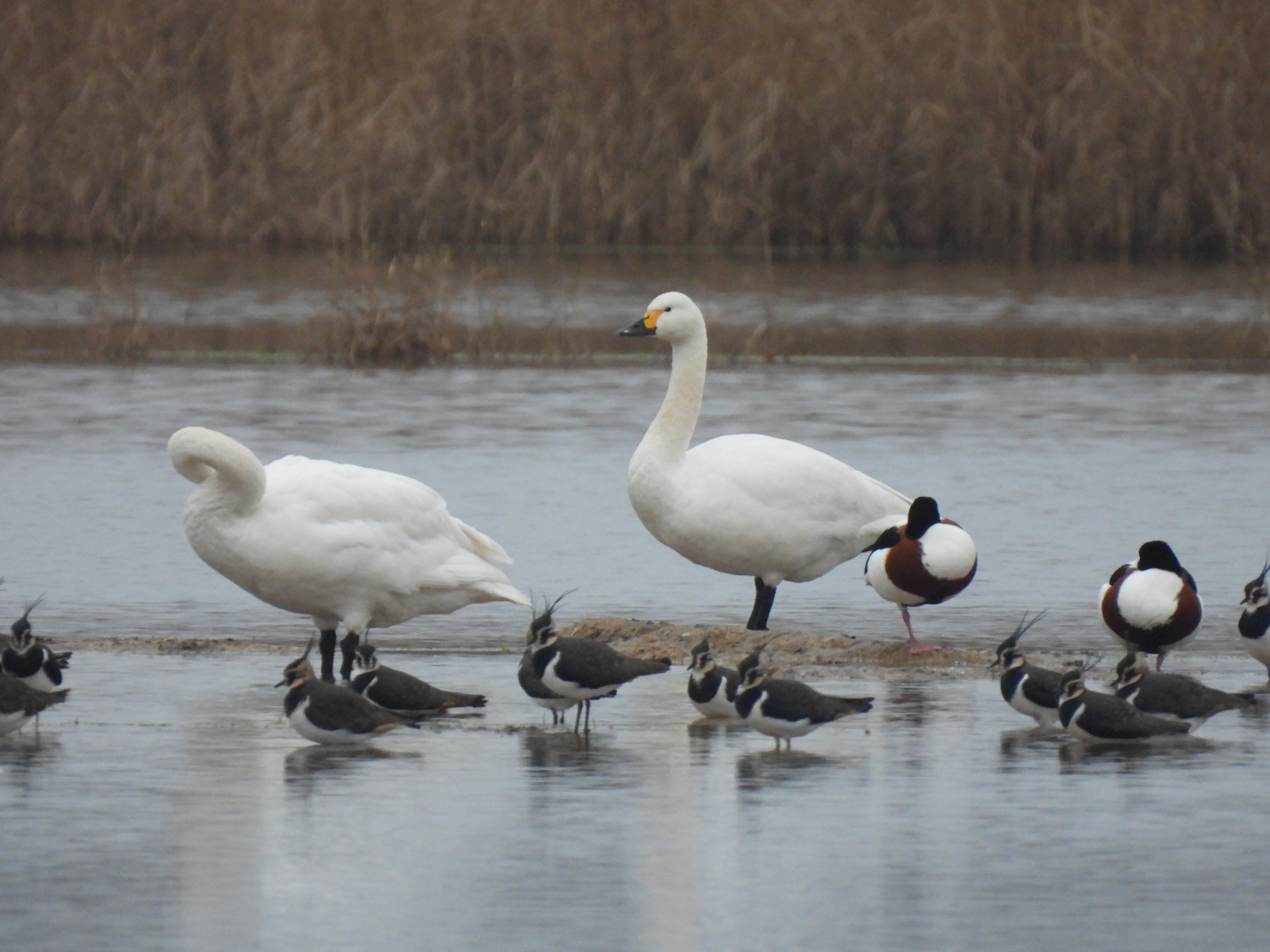
The Väinameri Conservation Area () is a protected area in Estonia. The Väinameri Conservation Area was established in 2007 to protect the ''Väinameri Conservation Area'' and the surrounding coastal area. The conservation area consists of the Väinameri Sea and the partial conservation areas of four counties; the Hiiu sub-conservation area, the Lääne County sub-conservation area, the Pärnu County sub-conservation area, and the Saare sub-conservation area. It has also been designated an Important Bird Area (IBA) by BirdLife International. The conservation area protects, for example, coastal lakes, underwater sand dunes, small islands, islets and coastal meadows, as well as the habitats of many protected species (''Cypripedium calceolus'', northern shoveler, tundra swan). See also * Protected areas of Estonia Protected areas of Estonia are regulated by the Nature Conservation Act (), which was passed by the Riigikogu, Estonian parliament on April 21, 2004 and entered i ... [...More Info...] [...Related Items...] OR: [Wikipedia] [Google] [Baidu] |
Väinameri Location Map
The Väinameri (Estonian language, Estonian for ''Strait Sea'' or ''Sea of Straits''; ) or Väinameri Sea is a strait and sub-bay of the Baltic Sea, located between the West Estonian Archipelago and the Estonian mainland, within western Estonia. It is the northern section of the Gulf of Riga, extending north to the eastern Baltic Sea. The area of the Väinameri Sea is about . The Väinameri Sea is home to the Väinameri Conservation Area, Väinameri Conservation area. The Kumari Channel is a shipping lane running north–south in the Väinameri. It is 35 km long and has a minimum depth of five metres. The Rukki Channel runs east–west between Hiiumaa and the port of Rohuküla on the mainland. In World War One it was the site of a major Battle of Moon Sound, naval battle between Germany and Post Imperial Russia. See also * Moonsund Regatta References External links Gulf of Riga Straits of the Baltic Sea Straits of Estonia Saaremaa {{Latvia-geo-s ... [...More Info...] [...Related Items...] OR: [Wikipedia] [Google] [Baidu] |
BirdLife International
BirdLife International is a global partnership of non-governmental organizations that strives to conserve birds and their habitats. BirdLife International's priorities include preventing extinction of bird species, identifying and safeguarding important sites for birds, maintaining and restoring key bird habitats, and empowering conservationists worldwide. It has a membership of more than 2.5 million people across List of BirdLife International national partner organisations, 116 country partner organizations, including the Royal Society for the Protection of Birds, the Wild Bird Society of Japan, the National Audubon Society, and American Bird Conservancy. BirdLife International has identified 13,000 Important Bird Area, Important Bird and Biodiversity Areas and is the official International Union for Conservation of Nature's IUCN Red List, Red List authority for birds. BirdLife International has established that 1,375 bird species (13% of the total) are threatened with extinc ... [...More Info...] [...Related Items...] OR: [Wikipedia] [Google] [Baidu] |
Protected Areas Of Estonia
Protected areas of Estonia are regulated by the Nature Conservation Act (), which was passed by the Riigikogu, Estonian parliament on April 21, 2004 and entered into force May 10, 2004. Overall Estonia has 15403 protected areas covering 21% of the country land and 18% of it marine and coastal territory,Estonia Protected Planet including 6 national parks: Lahemaa National Park, Karula National Park, Soomaa National Park,Vilsandi National Park, Matsalu National Park, and Alutaguse National Park Protected areas As stated in §10.1: An area shall be placed under protection as a protected area or a special conservation area by a regulation of the Government of the Republic of Estonia, Government of the Republic. According to the law, protected areas are areas maintained in a state unaltered by human act ...[...More Info...] [...Related Items...] OR: [Wikipedia] [Google] [Baidu] |
Tundra Swan
The tundra swan (''Cygnus columbianus'') is a small swan of the Holarctic. The two taxa within it are usually regarded as conspecific, but are also sometimes split into two species: Bewick's swan (''Cygnus bewickii'') of the Palaearctic and the whistling swan (''C. columbianus'') proper of the Nearctic. Birds from eastern Russia (roughly east of the Taymyr Peninsula) are sometimes separated as the subspecies ''C. c. jankowskii'', but this is not widely accepted as distinct, with most authors including them in ''C. c. bewickii''. Tundra swans are sometimes separated in the subgenus ''Olor'' together with the other Arctic swan species. Bewick's swan was named in 1830 by William Yarrell after the engraver Thomas Bewick, who specialised in illustrations of birds and animals. ''Cygnus'' is the Latin for "swan", and '' columbianus'' comes from the Columbia River, the type locality. Description ''C. columbianus'' is the smallest of the Holarctic swans, at in length, in wingspan and ... [...More Info...] [...Related Items...] OR: [Wikipedia] [Google] [Baidu] |
Northern Shoveler
The northern shoveler (; ''Spatula clypeata''), known simply in Britain as the shoveler, is a common and widespread duck. It breeds in northern areas of Europe and throughout the Palearctic and across most of North America, and winters in southern Europe, the Indian subcontinent, Southeast Asia, Central America, the Caribbean, and northern South America. It is a rare vagrant to Australia. In North America, it breeds along the southern edge of Hudson Bay and west of this body of water, and as far south as the Great Lakes west to Colorado, Nevada, and Oregon. The northern shoveler is one of the species to which the ''Agreement on the Conservation of African-Eurasian Migratory Waterbirds'' ( AEWA) applies. The conservation status of this bird is Least Concern. Taxonomy The Northern Shoveler was first formally described by the Swedish naturalist Carl Linnaeus in 1758 in the tenth edition of his ''Systema Naturae''. He introduced the binomial name ''Anas clypeata''. A molecular ... [...More Info...] [...Related Items...] OR: [Wikipedia] [Google] [Baidu] |
Cypripedium Calceolus
''Cypripedium calceolus'' is a lady's-slipper orchid, and the type species of the genus ''Cypripedium''. It is native to Europe and Asia. Taxonomy ''Cypripedium'' comes from the Greek Κύπρις πεδίον (''Kypris pedion''), meaning Aphrodite's foot (a reference to the goddess Aphrodite, equivalent to the Roman Venus). ''calceolus'' is Latin for a small shoe. ''Cypripedium calceolus'' does not occur in North America, though the closely related '' Cypripedium parviflorum'' and '' C. pubescens'' are often still referred to as subspecies or varieties of ''C. calceolus''. Description This is the largest-flowered orchid species in Europe, growing to 60 cm tall with flowers as wide as 9 cm. Before it flowers, it is distinguished from other orchids by the large size and width of its ovate leaves (as big as 18 cm long, 9 cm wide), which like other orchids exhibit parallel venation. Each shoot has up to four leaves and a small number of flowers (typically one o ... [...More Info...] [...Related Items...] OR: [Wikipedia] [Google] [Baidu] |
Coastal Meadow
Coastal meadows are meadows in the coastal zone, influenced by the sea. Under this definition, the salinity of the air and wind is usually high and the flora is dominated by salt-tolerant species. Some coastal meadows may be flooded by seawater occasionally, increasing the demands on the flora even further. These conditions however, do not make a meadow. To be categorized as a meadow in the first place, the plant growth has to be low in height, and normally this can only be achieved from wear by general traffic or grazing of the landscape (artificially or by livestock). Coastal meadows are therefore usually thought of as cultural landscapes or biotopes, requiring some degree of intervention and not being able to sustain themselves on their own. If left alone, coastal meadows would often transform into a transitional meadow and eventually a shrubby or bushy seashore habitat. Depending on the geology, climate and local conditions, coastal meadows can take on different expressions, ... [...More Info...] [...Related Items...] OR: [Wikipedia] [Google] [Baidu] |
Islet
An islet ( ) is generally a small island. Definitions vary, and are not precise, but some suggest that an islet is a very small, often unnamed, island with little or no vegetation to support human habitation. It may be made of rock, sand and/or hard coral; may be permanent or tidal (i.e. surfaced reef or seamount); and may exist in the sea, lakes, rivers or any other sizeable bodies of water. Definition As suggested by its origin ''islette'', an Old French diminutive of "isle", use of the term implies small size, but little attention is given to drawing an upper limit on its applicability. The World Landforms website says, "An islet landform is generally considered to be a rock or small island that has little vegetation and cannot sustain human habitation", and further that size may vary from a few square feet to several square miles, with no specific rule pertaining to size. Other terms * Ait (/eɪt/, like eight) or eyot (/aɪ(ə)t, eɪt/), a small island. It is espe ... [...More Info...] [...Related Items...] OR: [Wikipedia] [Google] [Baidu] |
Important Bird Area
An Important Bird and Biodiversity Area (IBA) is an area identified using an internationally agreed set of criteria as being globally important for the conservation of bird populations. IBA was developed and sites are identified by BirdLife International. There are over 13,000 IBAs worldwide. These sites are small enough to be entirely conserved and differ in their character, habitat or ornithological importance from the surrounding habitat. In the United States the program is administered by the National Audubon Society. Often IBAs form part of a country's existing protected area network, and so are protected under national legislation. Legal recognition and protection of IBAs that are not within existing protected areas varies within different countries. Some countries have a National IBA Conservation Strategy, whereas in others protection is completely lacking. History In 1985, following a specific request from the European Economic Community, Birdlife International dr ... [...More Info...] [...Related Items...] OR: [Wikipedia] [Google] [Baidu] |
Protected Area
Protected areas or conservation areas are locations which receive protection because of their recognized natural or cultural values. Protected areas are those areas in which human presence or the exploitation of natural resources (e.g. firewood, non-timber forest products, water, ...) is limited. The term "protected area" also includes marine protected areas and transboundary protected areas across multiple borders. As of 2016, there are over 161,000 protected areas representing about 17 percent of the world's land surface area (excluding Antarctica). For waters under national jurisdiction beyond inland waters, there are 14,688 Marine Protected Areas (MPAs), covering approximately 10.2% of coastal and marine areas and 4.12% of global ocean areas. In contrast, only 0.25% of the world's oceans beyond national jurisdiction are covered by MPAs. In recent years, the 30 by 30 initiative has targeted to protect 30% of ocean territory and 30% of land territory worldwide by 2030; this ... [...More Info...] [...Related Items...] OR: [Wikipedia] [Google] [Baidu] |
Saaremaa (county)
Saare County ( or ''Saaremaa''; ; ; ; ) is one of 15 counties of Estonia. It consists of Saaremaa, the largest island of Estonia, and several smaller islands near it, most notably Muhu, Ruhnu, Abruka and Vilsandi. The county borders Lääne County to the east, Hiiu County to the north, and Latvia to the south. In 2022, Saare County had a population of 31,292, which was 2.4% of the population of Estonia. Municipalities The county is subdivided into municipalities. There are 3 rural municipalities ( – parishes) in Saare County. Geography The largest islands of the county are Saaremaa, Muhu, Ruhnu, Abruka and Vilsandi. Arable land is and it has a mild maritime climate. The mean annual air temperature is and the mean annual precipitation is . Religion The largest number of congregations in the county are of the Estonian Evangelical Lutheran Church (EELC) and there are 15 congregations in the county, which are administered by the EELC's Saarte Deanery. 14 Orthodox congr ... [...More Info...] [...Related Items...] OR: [Wikipedia] [Google] [Baidu] |
Pärnu County
Pärnu County ( or ''Pärnumaa''; ) is one of 15 counties of Estonia. It is situated in the south-western part of the country, on the coast of Gulf of Riga, and borders Lääne and Rapla counties to the north, Järva and Viljandi counties to the east, and Latvia to the south. In 2022, Pärnu County had a population of 85,705 – constituting 6.4% of the total population of Estonia. Pärnu County is the largest county of Estonia in terms of land area. History In Pärnu county, there is the oldest known human settlement in Estonia, which is the town of Sindi, and it is up the Pärnu River, near the village of Pulli. It dates back to 8500 BCE in the Mesolithic historical period. County government The administrative reform in Estonia abolished county governments by the end of 2017. Before that, counties were led by a governor, who was appointed by the Government of Estonia for a term of five years. Previous county governors: * 1993–2009: Toomas Kivimägi * 201 ... [...More Info...] [...Related Items...] OR: [Wikipedia] [Google] [Baidu] |


