|
Varve
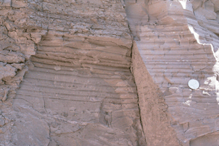
A varve is an annual layer of sediment or sedimentary rock. The word 'varve' derives from the Swedish word ''varv'' whose meanings and connotations include 'revolution', 'in layers', and 'circle'. Of the many rhythmites in the geological record, varves are one of the most important and illuminating in studies of past climate change. Varves are amongst the smallest-scale events recognised in stratigraphy. An annual layer can be highly visible because the particles washed into the layer in the spring when there is greater flow strength are much coarser than those deposited later in the year. This forms a pair of layers—one coarse and one fine—for each annual cycle. Varves form only in fresh or brackish water, because the high levels of salt in normal sea water coagulate the clay into coarse grains. Since the saline waters leave coarse particles all year, it is nearly impossible to distinguish the individual layers in salt waters. Indeed, clay flocculation occurs at high ioni ... [...More Info...] [...Related Items...] OR: [Wikipedia] [Google] [Baidu] |
Gerard De Geer
Baron Gerard Jacob De Geer (20 November 1858 – 24 July 1943) was a Swedish geologist who made significant contributions to Quaternary geology, particularly geomorphology and geochronology. De Geer is best known for his work on varves. In 1890 De Geer was the first to apply the name Ancylus Lake to the Baltic paleolake discovered by Henrik Munthe. He subsequently participated the protracted scientific controversy surrounding this lake. Biography Baron Gerard Jacob De Geer comes from a well-known Swedish aristocratic family of Brabant origin, who had emigrated to Sweden in the early seventeenth century. His family included prominent industrialists and politicians. His father Louis and older brother Gerhard Louis served as the Prime Minister of Sweden. Gerard Jacob was born on 2 October 1858, in Stockholm in the family of Baron Louis Gerhard de Geer, at that time the first Minister of Justice in the Swedish government, and Carolina de Geer, née Countess Wachtmeister. Si ... [...More Info...] [...Related Items...] OR: [Wikipedia] [Google] [Baidu] |
Rhythmite
A rhythmite consists of layers of sediment or sedimentary rock which are laid down with an obvious periodicity and regularity. They may be created by annual processes such as seasonally varying deposits reflecting variations in the runoff cycle, by shorter term processes such as tides, or by longer term processes such as periodic floods. Rhythmites serve a significant role in unraveling prehistoric events, providing insights into sea level change, glaciation change, and Earth's orbital variations which serve to answer questions about climate change. Annually-laminated rhythmites Annually-laminated deposits ( varves) are rhythmites with annual periodicity: annual layers of sediment or sedimentary rock are laid down through seasonal variations that result from precipitation, or from temperature, which influences precipitation rates and debris loads in runoff. Of the many rhythmites found in the geological record, varves are among the most important and illuminating to studies of ... [...More Info...] [...Related Items...] OR: [Wikipedia] [Google] [Baidu] |
Carl Caldenius
Carl Caldenius (1887–1961), until 1920 known by the surname Carlzon, was a Swedish Quaternary geologist and geotechnical engineer. He is mostly known for his geochronological work in Patagonia. Caldenius worked as geotechnical engineer for the Swedish State Railways until 1922 when he started to work full-time with his PhD thesis "Ragundasjöns stratigrafi och geokronologi" (Stratigraphy and geochronology of Lake Ragunda) that he defended in 1924. In 1925 he travelled to Argentina as part of a Swedish-Argentine collaboration to extend the clay varve chronology of Gerard De Geer to the Southern Hemisphere. After returning to Swedsen in 1930 he joined an expedition to Australia and New Zealand where he applied knowledge of varves to study the Carboniferous The Carboniferous ( ) is a Geologic time scale, geologic period and System (stratigraphy), system of the Paleozoic era (geology), era that spans 60 million years, from the end of the Devonian Period Ma (million years ag ... [...More Info...] [...Related Items...] OR: [Wikipedia] [Google] [Baidu] |
Sedimentary Rock
Sedimentary rocks are types of rock (geology), rock formed by the cementation (geology), cementation of sediments—i.e. particles made of minerals (geological detritus) or organic matter (biological detritus)—that have been accumulated or deposited at Earth's surface. Sedimentation is any process that causes these particles to settle in place. Geological detritus originates from weathering and erosion of existing rocks, or from the solidification of molten lava blobs erupted by volcanoes. The geological detritus is transported to the place of deposition by water, wind, ice or Mass wasting, mass movement, which are called agents of denudation. Biological detritus is formed by bodies and parts (mainly shells) of dead aquatic organisms, as well as their fecal mass, suspended in water and slowly piling up on the floor of water bodies (marine snow). Sedimentation may also occur when dissolved minerals precipitate from aqueous solution, water solution. The sedimentary rock cover of ... [...More Info...] [...Related Items...] OR: [Wikipedia] [Google] [Baidu] |
Stratigraphy
Stratigraphy is a branch of geology concerned with the study of rock layers (strata) and layering (stratification). It is primarily used in the study of sedimentary and layered volcanic rocks. Stratigraphy has three related subfields: lithostratigraphy (lithologic stratigraphy), biostratigraphy (biologic stratigraphy), and chronostratigraphy (stratigraphy by age). Historical development Catholic priest Nicholas Steno established the theoretical basis for stratigraphy when he introduced the law of superposition, the principle of original horizontality and the principle of lateral continuity in a 1669 work on the fossilization of organic remains in layers of sediment. The first practical large-scale application of stratigraphy was by William Smith in the 1790s and early 19th century. Known as the "Father of English geology", Smith recognized the significance of strata or rock layering and the importance of fossil markers for correlating strata; he created the first geo ... [...More Info...] [...Related Items...] OR: [Wikipedia] [Google] [Baidu] |
Dendrochronology
Dendrochronology (or tree-ring dating) is the scientific method of chronological dating, dating tree rings (also called growth rings) to the exact year they were formed in a tree. As well as dating them, this can give data for dendroclimatology, the study of climate and atmospheric conditions during different periods in history from the wood of old trees. Dendrochronology derives from the Ancient Greek (), meaning "tree", (), meaning "time", and (), "the study of". Dendrochronology is useful for determining the precise age of samples, especially those that are too recent for radiocarbon dating, which always produces a range rather than an exact date. However, for a precise date of the death of the tree a full sample to the edge is needed, which most trimmed timber will not provide. It also gives data on the timing of events and rates of change in the environment (most prominently climate) and also in wood found in archaeology or works of art and architecture, such as old pane ... [...More Info...] [...Related Items...] OR: [Wikipedia] [Google] [Baidu] |
Asia
Asia ( , ) is the largest continent in the world by both land area and population. It covers an area of more than 44 million square kilometres, about 30% of Earth's total land area and 8% of Earth's total surface area. The continent, which has long been home to the majority of the human population, was the site of many of the first civilisations. Its 4.7 billion people constitute roughly 60% of the world's population. Asia shares the landmass of Eurasia with Europe, and of Afro-Eurasia with both Europe and Africa. In general terms, it is bounded on the east by the Pacific Ocean, on the south by the Indian Ocean, and on the north by the Arctic Ocean. The border of Asia with Europe is a social constructionism, historical and cultural construct, as there is no clear physical and geographical separation between them. A commonly accepted division places Asia to the east of the Suez Canal separating it from Africa; and to the east of the Turkish straits, the Ural Mountains an ... [...More Info...] [...Related Items...] OR: [Wikipedia] [Google] [Baidu] |
Tierra Del Fuego
Tierra del Fuego (, ; Spanish for "Land of Fire", rarely also Fireland in English) is an archipelago off the southernmost tip of the South America, South American mainland, across the Strait of Magellan. The archipelago consists of the main island, Isla Grande de Tierra del Fuego, with an area of , along with numerous smaller islands, including Cape Horn and Diego Ramírez Islands. The western part of the Tierra del Fuego archipelago, about two-thirds including its many islands, is part of Chile, and the eastern part is part of Argentina. The southernmost extent of the archipelago, Cape Horn, lies just north of latitude 56th parallel south, 56°S. The earliest-known human settlement in Tierra del Fuego dates to approximately 8,000 BC. Europeans first explored the islands during Ferdinand Magellan's expedition of 1520. ''Tierra del Fuego'' ("Land of Fire") and similar names stem from sightings of the many fires that the inhabitants built along the coastline and possibly even in ... [...More Info...] [...Related Items...] OR: [Wikipedia] [Google] [Baidu] |
Patagonia
Patagonia () is a geographical region that includes parts of Argentina and Chile at the southern end of South America. The region includes the southern section of the Andes mountain chain with lakes, fjords, temperate rainforests, and glaciers in the west and Patagonian Desert, deserts, Plateaus, tablelands, and steppes to the east. Patagonia is bounded by the Pacific Ocean on the west, the Atlantic Ocean to the east, and many bodies of water that connect them, such as the Strait of Magellan, the Beagle Channel, and the Drake Passage to the south. The northern limit of the region is not precisely defined; the Colorado River, Argentina, Colorado and Barrancas River, Barrancas rivers, which run from the Andes to the Atlantic, are commonly considered the northern limit of Argentine Patagonia. The archipelago of Tierra del Fuego is sometimes considered part of Patagonia. Most geographers and historians locate the northern limit of Chilean Patagonia at Huincul Fault, in Araucanía R ... [...More Info...] [...Related Items...] OR: [Wikipedia] [Google] [Baidu] |
Edward Hitchcock
Edward Hitchcock (May 24, 1793 – February 27, 1864) was an American geologist and the third President of Amherst College (1845–1854). Life Born to poor parents, he attended newly founded Deerfield Academy, where he was later principal, from 1815 to 1818. In 1821 he was ordained as a Congregationalist pastor and served as pastor of the Congregational Church in Conway, Massachusetts, 1821–1825. He left the ministry to become Professor of Chemistry and Natural History at Amherst College. He held that post from 1825 to 1845, serving as Professor of Natural Theology and Geology from 1845 until his death in 1864. In 1845, Hitchcock became President of the College, a post he held until 1854. As president, Hitchcock was responsible for Amherst's recovery from severe financial difficulties. He is also credited with developing the college's scientific resources and establishing its reputation for scientific teaching. In addition to his positions at Amherst, Hitchcock was a wel ... [...More Info...] [...Related Items...] OR: [Wikipedia] [Google] [Baidu] |
Hudson Bay
Hudson Bay, sometimes called Hudson's Bay (usually historically), is a large body of Saline water, saltwater in northeastern Canada with a surface area of . It is located north of Ontario, west of Quebec, northeast of Manitoba, and southeast of Nunavut, but politically entirely part of Nunavut. It is an inland sea, inland List of seas on Earth#Marginal seas by ocean, marginal sea of the Arctic Ocean. The Hudson Strait provides a connection between the Labrador Sea and the Atlantic Ocean in the northeast, while the Foxe Channel connects Hudson Bay with the Arctic Ocean in the north. The Hudson Bay drainage basin drains a very large area, about , that includes parts of southeastern Nunavut, Alberta, Saskatchewan, Ontario, Quebec, all of Manitoba, and parts of the U.S. states of North Dakota, South Dakota, Minnesota, and Montana. Hudson Bay's southern arm is called James Bay. The East Cree, Eastern Cree name for Hudson and James Bay is (southern dialect) or (northern dialect), m ... [...More Info...] [...Related Items...] OR: [Wikipedia] [Google] [Baidu] |
Lake Timiskaming
Lake Timiskaming or Lake Temiskaming (, ) is a large freshwater lake on the Provinces and territories of Canada, provincial boundary between Ontario and Quebec, Canada. The lake, which forms part of the Ottawa River, is in length and covers an area of . Its water level ranges between and above sea-level, with a mean annual average of . The lake is in places up to deep. There are several islands on the lake, notably Mann and du Collège Islands. The name is from the Algonquin language, Algonquin ''Temikami'' or ''Temikaming'', meaning "deep body of water with rapid winds” There are 30 species of fish in Lake Timiskaming, the best known are northern pike, sturgeon, lake trout, walleye, smallmouth bass, Ameiurus, bullhead, carp, burbot, Yellow perch, perch, and Freshwater whitefish, whitefish. The lake was shaped during the last ice age when glaciers carved into the rock. It is also the remnants of a huge basin called Lake Ojibway, which existed about 9,500 years ago. Fo ... [...More Info...] [...Related Items...] OR: [Wikipedia] [Google] [Baidu] |


