|
Umiken
Umiken was a municipality in the district of Brugg in the canton of Aargau in Switzerland. On 1 January 2010 the municipality of Umiken merged into Brugg , neighboring_municipalities = Gebenstorf, Habsburg, Hausen, Holderbank, Lupfig, Riniken, Rüfenach, Schinznach, Untersiggenthal, Villigen, Villnachern, Veltheim, Windisch , twintowns = Rottweil (Germany) , website .... Economy there was a total of 525 workers who lived in the municipality. Of these, 472 or about 89.9% of the residents worked outside Umiken while 45 people commuted into the municipality for work. There were a total of 98 jobs (of at least 6 hours per week) in the municipality. accessed 21 January 2010 Refer ...
|
Brugg
, neighboring_municipalities = Gebenstorf, Habsburg, Hausen, Holderbank, Lupfig, Riniken, Rüfenach, Schinznach, Untersiggenthal, Villigen, Villnachern, Veltheim, Windisch , twintowns = Rottweil (Germany) , website = www.stadt-brugg.ch Brugg (sometimes written as Brugg AG in order to distinguish it from other ''Brugg''s) is a Swiss municipality and a town in the canton of Aargau and is the seat of the district of the same name. The town is located at the confluence of the Aare, Reuss, and Limmat, with the Aare flowing through its medieval part. It is located approximately from the cantonal capital of Aarau; from Zürich; and about from Basel. Brugg is the Swiss German term for bridge (german: Brücke). This is an allusion to the purpose of the medieval town's establishment under the Habsburgs, as the town is located at the narrowest point on the Aare in the Swiss midlands. The Habsburgs’ oldest known residence is located in ... [...More Info...] [...Related Items...] OR: [Wikipedia] [Google] [Baidu] |
Riniken
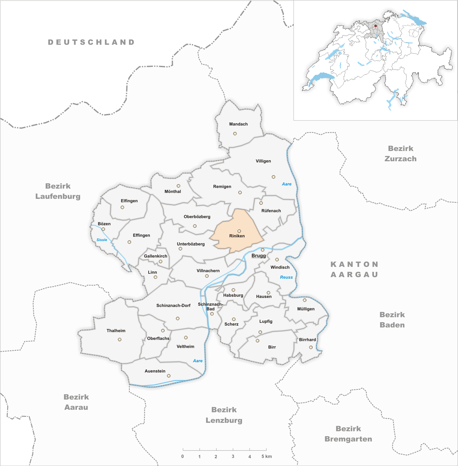
Riniken is a municipality in the district of Brugg in the canton of Aargau in Switzerland. History While Iberg Castle was built in the 11th Century and abandoned in 1200, the village of Riniken is first mentioned in 1253 as ''Rinikon''. The rights to high justice were held by the Habsburgs until 1460, when the rights went to the bailiwick of Schenkenberg under the city of Bern. The low justice right was held, until 1406, by Königsfelden Abbey and after the Protestant Reformation those rights transferred to Bözberg. Religiously, Riniken belonged to the Umiken parish. In 1967 the village received a private cemetery, and in 1978 an ecumenical ecclesiastical center. Starting in 1712, there was a migration of villagers to Dättwil (now part of Baden), as agriculture offered very little money. There was never any industry in Riniken, but in 1960 about half of the workforce worked in the second sector. The recent population growth is mainly due to commuters who have moved in ... [...More Info...] [...Related Items...] OR: [Wikipedia] [Google] [Baidu] |
Brugg (district)
Brugg District is a district in the Canton of Aargau, Switzerland. The capital of the district is the town of Brugg, Switzerland, Brugg. Geography Brugg District has an area, , of . Of this area, 42.6% is used for agricultural purposes, while 41.3% is forested. The rest of the land, (14.1%) is settled. It is located around the rivers Aare and Reuss (river), Reuss. The northern part of the district, north of the Aare, lies in the Aargau part of the Jura mountains. Demographics Brugg District has a population () of 46,471.Statistical Department of Canton Aargau -Bereich 01 -Bevölkerung accessed 20 January 2010 , there were 1,635 homes with 1 or 2 persons in the household, 8,736 homes with 3 or 4 persons in the household, and 6,792 homes with 5 or more persons in the household. The average number of pe ... [...More Info...] [...Related Items...] OR: [Wikipedia] [Google] [Baidu] |
Unterbözberg
Unterbözberg is a former municipality in the district of Brugg in the canton of Aargau in Switzerland. On 1 January 2013 the former municipalities of Gallenkirch, Linn, Oberbözberg and Unterbözberg merged to form the new municipality of Bözberg.Amtliches Gemeindeverzeichnis der Schweiz published by the Swiss Federal Statistical Office accessed 2 January 2013 History Unterbözberg is first mentioned in 1189 as ''Bozeberch''. Until 1873, the municipality was part of Bözberg, which split into and Unterbözberg.Geography [...More Info...] [...Related Items...] OR: [Wikipedia] [Google] [Baidu] |
Villnachern
Villnachern is a municipality in the district of Brugg in the canton of Aargau in Switzerland. Geography Villnachern has an area, , of . Of this area, or 29.1% is used for agricultural purposes, while or 49.7% is forested. Of the rest of the land, or 12.5% is settled (buildings or roads), or 7.0% is either rivers or lakes and or 0.7% is unproductive land.Swiss Federal Statistical Office-Land Use Statistics 2009 data accessed 25 March 2010 Of the built up area, housing and buildings made up 7.8% and transportation infrastructure made up 4.2%. 46.9% of the total land area is heavily forested and 2.8% is covered with orchards or small clusters of trees. Of the agricultural land, 17.1% is used for growing crops and 9.2% is pastures, while 2.8% is u ... [...More Info...] [...Related Items...] OR: [Wikipedia] [Google] [Baidu] |
Municipalities Of Switzerland
Municipalities (german: Gemeinden, ' or '; french: communes; it , comuni; rm, vischnancas) are the lowest level of administrative division in Switzerland. Each municipality is part of one of the Swiss cantons, which form the Swiss Confederation. In most cantons, municipalities are also part of districts or other sub-cantonal administrative divisions. There are 2,136 municipalities . Their populations range between several hundred thousand (Zürich), and a few dozen people ( Kammersrohr, Bister), and their territory between 0.32 km² (Rivaz) and 439 km² ( Scuol). History The beginnings of the modern municipality system date back to the Helvetic Republic. Under the Old Swiss Confederacy, citizenship was granted by each town and village to only residents. These citizens enjoyed access to community property and in some cases additional protection under the law. Additionally, the urban towns and the rural villages had differing rights and laws. The creation of a uniform ... [...More Info...] [...Related Items...] OR: [Wikipedia] [Google] [Baidu] |
Cantons Of Switzerland
The 26 cantons of Switzerland (german: Kanton; french: canton ; it, cantone; Sursilvan and Surmiran: ; Vallader and Puter: ; Sutsilvan: ; Rumantsch Grischun: ) are the member states of the Swiss Confederation. The nucleus of the Swiss Confederacy in the form of the first three confederate allies used to be referred to as the . Two important periods in the development of the Old Swiss Confederacy are summarized by the terms ('Eight Cantons'; from 1353–1481) and ('Thirteen Cantons', from 1513–1798).rendered "the 'confederacy of eight'" and "the 'Thirteen-Canton Confederation'", respectively, in: Each canton of the Old Swiss Confederacy, formerly also ('lieu/locality', from before 1450), or ('estate', from ), was a fully sovereign state with its own border controls, army, and currency from at least the Treaty of Westphalia (1648) until the establishment of the Swiss federal state in 1848, with a brief period of centralised government during the Helvetic Repub ... [...More Info...] [...Related Items...] OR: [Wikipedia] [Google] [Baidu] |
Aargau
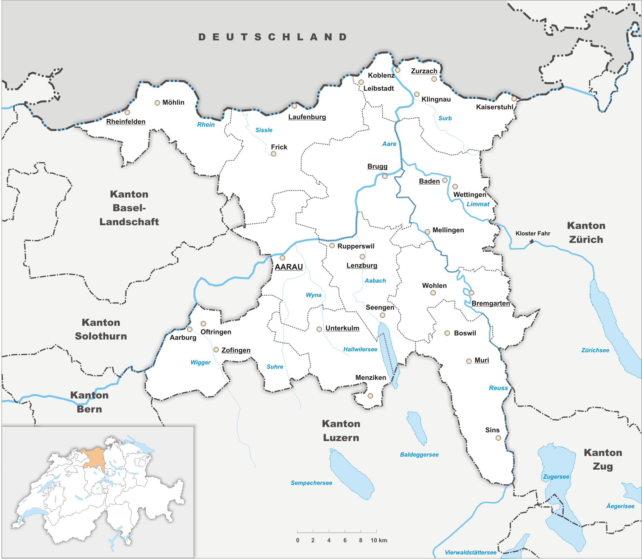
Aargau, more formally the Canton of Aargau (german: Kanton Aargau; rm, Chantun Argovia; french: Canton d'Argovie; it, Canton Argovia), is one of the 26 cantons forming the Swiss Confederation. It is composed of eleven districts and its capital is Aarau. Aargau is one of the most northerly cantons of Switzerland. It is situated by the lower course of the Aare River, which is why the canton is called ''Aar- gau'' (meaning "Aare province"). It is one of the most densely populated regions of Switzerland. History Early history The area of Aargau and the surrounding areas were controlled by the Helvetians, a member of the Celts, as far back as 200 BC. It was eventually occupied by the Romans and then by the 6th century, the Franks. The Romans built a major settlement called Vindonissa, near the present location of Brugg. Medieval Aargau The reconstructed Old High German name of Aargau is ''Argowe'', first unambiguously attested (in the spelling ''Argue'') in 795. Th ... [...More Info...] [...Related Items...] OR: [Wikipedia] [Google] [Baidu] |
Switzerland
). Swiss law does not designate a ''capital'' as such, but the federal parliament and government are installed in Bern, while other federal institutions, such as the federal courts, are in other cities (Bellinzona, Lausanne, Luzern, Neuchâtel, St. Gallen a.o.). , coordinates = , largest_city = Zürich , official_languages = , englishmotto = "One for all, all for one" , religion_year = 2020 , religion_ref = , religion = , demonym = , german: Schweizer/Schweizerin, french: Suisse/Suissesse, it, svizzero/svizzera or , rm, Svizzer/Svizra , government_type = Federal assembly-independent directorial republic with elements of a direct democracy , leader_title1 = Federal Council , leader_name1 = , leader_title2 = , leader_name2 = Walter Thurnherr , legislature = Federal Assembly , upper_house = Council of ... [...More Info...] [...Related Items...] OR: [Wikipedia] [Google] [Baidu] |
Former Municipalities Of Aargau
A former is an object, such as a template, gauge or cutting die, which is used to form something such as a boat's hull. Typically, a former gives shape to a structure that may have complex curvature. A former may become an integral part of the finished structure, as in an aircraft fuselage, or it may be removable, being using in the construction process and then discarded or re-used. Aircraft formers Formers are used in the construction of aircraft fuselage, of which a typical fuselage has a series from the nose to the empennage, typically perpendicular to the longitudinal axis of the aircraft. The primary purpose of formers is to establish the shape of the fuselage and reduce the column length of stringers to prevent instability. Formers are typically attached to longerons, which support the skin of the aircraft. The "former-and-longeron" technique (also called stations and stringers) was adopted from boat construction, and was typical of light aircraft built until the adv ... [...More Info...] [...Related Items...] OR: [Wikipedia] [Google] [Baidu] |


