|
Unité Kasaïenne
Kasaï-Occidental (French language, French for "Western Kasai"; ) was one of the eleven provinces of the Democratic Republic of the Congo between 1966 and 2015, when it was split into the Kasaï-Central and the Kasai Province, Kasaï provinces. History The province of Kasaï-Occidental was established in 1966 by regrouping the provinces of Luluabourg and Unité Kasaïenne which in turn were created 1962 when the historical Kasaï (former province), Kasaï Province was divided in five provinces namely Lomami, Sankuru, Sud-Kasai, Luluabourg, Unité-Kasaïenne. The former provinces of Luluabourg and Unité-Kasaïenne correspond to the current districts of Lulua District and Kasaï District. Since its formation the provincial seat is Kananga (formerly Luluabourg) which was also the seat of the Kasaï Province between 1957 and 1962. The Province of Lusambo precedes the current entity, it was created 1933 by carving out the districts of Kasai and Sankuru from the Province of Congo-Kasa ... [...More Info...] [...Related Items...] OR: [Wikipedia] [Google] [Baidu] |
Provinces Of The Democratic Republic Of The Congo
Article 2 of the Constitution of the Democratic Republic of the Congo divides the country into the capital city of Kinshasa and 25 named provinces. It also gives the capital the status of a province. Therefore, in many contexts Kinshasa is regarded as the 26th province. List History When Belgium annexed the Belgian Congo as a colony in November 1908, it was initially organised into 22 districts. Ten western districts were administered directly by the main colonial government, while the eastern part of the colony was administered under two vice-governments: eight northeastern districts formed Orientale Province, and four southeastern districts formed Katanga. In 1919, the colony was organised into four provinces: * Congo-Kasaï (five southwestern districts), * Équateur (five northwestern districts), * Orientale Province and Katanga (previous vice-governments). [...More Info...] [...Related Items...] OR: [Wikipedia] [Google] [Baidu] |
Congo-Kasaï
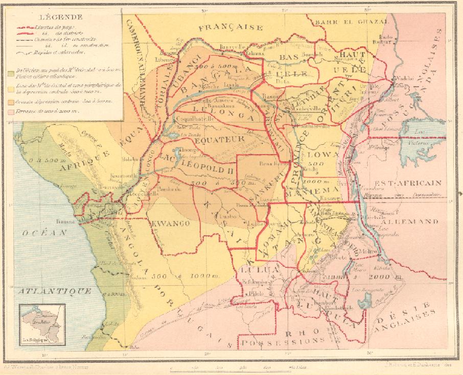
Congo-Kasaï was one of the four large provinces of the Belgian Congo defined in 1914. It was formally established in 1919, and in 1933 was divided into the new provinces of Léopoldville Province, Léopoldville and Lusambo Province, Lusambo. Location Congo-Kasaï was named after the Kasai River, a major left tributary of the Congo River that provides access to the region. By 1910 a factory of the Kasai Company had been established near Misumba, which had about two thousand inhabitants. The company had made successful trial rubber plantations. The company also bought rubber and ivory from the local people, some of whom used it to buy liquor from the Portuguese territory (Angola). Congo-Kasaï had five districts: the urban district of Léopoldville, capital of the colony, and the districts (from west to east) of Bas-Congo District, Bas-Congo, Kwango District, Kwango, Kasaï District, Kasaï and Sankuru District, Sankuru. The ''Huileries du Congo Belge'' company had two zones (o ... [...More Info...] [...Related Items...] OR: [Wikipedia] [Google] [Baidu] |
Dibaya
Dibaya is a small town in Kasai-Central province of southern Democratic Republic of the Congo. As of 2009 it had an estimated population of 5,213. Dibaya has an airport with regular flights to Kinshasa, Kikwit and Angola. As a result of the Kasaï-Central clashes, between February 9, 2017 and February 13, 2017, 101 Kamwina Nsapu militia members were killed by the Armed Forces of the Democratic Republic of the Congo Armed (May, 1941–1964) was an American Thoroughbred gelding race horse who was the American Horse of the Year in 1947 and Champion Older Male Horse in both 1946 and 1947. He was inducted into the National Museum of Racing and Hall of Fame ... in Dibaya. References Populated places in Kasaï-Central Communes of the Democratic Republic of the Congo {{DRC-geo-stub ... [...More Info...] [...Related Items...] OR: [Wikipedia] [Google] [Baidu] |
Demba, Democratic Republic Of The Congo
Demba is a town in Kasai-Central province in the southern part of the Democratic Republic of the Congo. As of 2009 it had an estimated population of 25,384. Transport Demba is served by the national railway system. See also * Railway stations in DRCongo References Populated places in Kasaï-Central Communes of the Democratic Republic of the Congo {{DRC-geo-stub ... [...More Info...] [...Related Items...] OR: [Wikipedia] [Google] [Baidu] |
Dekese
Dekese is a community in the Democratic Republic of the Congo, on the right bank of the Lukenie River. It is the administrative center of the Dekese territory of Kasai province. History Dekese was founded as a colonial post by Alexandre Delcommune around 1888. The territory is isolated. Roads are impassable and radio reception is very poor. The region suffered badly during the Second Congo War. In December 2001 there was an Ebola scare. Uganda, which was occupying the area, decided to screen all soldiers on their return home. The Kinshasa government asked the World Health Organization to help open a humanitarian corridor so they could also use the general hospital and medical personnel of Dekese. However, the illness had a much lower death rate than Ebola, with most of the victims being children under five and adults over 55, and appeared to be a respiratory disease. In October 2006 an outbreak of monkeypox was reported. The isolation of the region made it difficult to fight th ... [...More Info...] [...Related Items...] OR: [Wikipedia] [Google] [Baidu] |
Tshimbulu
Tshimbulu is a town in Kasaï-Central, Democratic Republic of the Congo The Democratic Republic of the Congo (DRC), also known as the DR Congo, Congo-Kinshasa, or simply the Congo (the last ambiguously also referring to the neighbouring Republic of the Congo), is a country in Central Africa. By land area, it is t .... References Populated places in Kasaï-Central {{KasaïCentral-geo-stub ... [...More Info...] [...Related Items...] OR: [Wikipedia] [Google] [Baidu] |
Luebo
Luebo or Lwebo is a town (officially a Communes of the Democratic Republic of the Congo, commune) of Kasai Province in south-central Democratic Republic of the Congo. It is also the seat of the Luebo Territory, territory of the same name. As of 2009 it had an estimated population of 40,115. History The town was founded in November 1885 by Ludwig Wolf and a group of other European colonists as an outpost of King Leopold II of Belgium's Congo Free State. The state used this outpost to claim the surrounding region, despite it already being inhabited, notably by the nearby Kuba Kingdom. The trading post was sold to the Sanford Exploring Expedition, an American company, in December 1886, and it was sold again to 1888 to the Société anonyme belge pour le commerce du Haut-Congo. A mission was founded in the town three years later, by William Henry Sheppard and Samuel Lapsley. In 1904 it again became property of the Congo Free State. In 1908, it was incorporated into the Belgian Congo ... [...More Info...] [...Related Items...] OR: [Wikipedia] [Google] [Baidu] |
Angola
Angola, officially the Republic of Angola, is a country on the west-Central Africa, central coast of Southern Africa. It is the second-largest Portuguese-speaking world, Portuguese-speaking (Lusophone) country in both total area and List of countries and dependencies by population, population and is the List of African countries by area, seventh-largest country in Africa. It is bordered by Namibia to the south, the Democratic Republic of the Congo to the north, Zambia to the east, and the Atlantic Ocean to the west. Angola has an Enclave and exclave, exclave province, the province of Cabinda Province, Cabinda, that borders the Republic of the Congo and the Democratic Republic of the Congo. The capital and most populous city is Luanda. Angola has been inhabited since the Paleolithic, Paleolithic Age. After the Bantu expansion reached the region, states were formed by the 13th century and organised into confederations. The Kingdom of Kongo ascended to achieve hegemony among the ... [...More Info...] [...Related Items...] OR: [Wikipedia] [Google] [Baidu] |
Katanga Province
Katanga was one of the four large provinces created in the Belgian Congo in 1914. It was one of the eleven provinces of the Democratic Republic of the Congo between 1966 and 2015, when it was split into the Tanganyika Province, Tanganyika, Haut-Lomami, Lualaba Province, Lualaba, and Haut-Katanga provinces. Between 1971 and 1997 (during the rule of Mobutu Sese Seko when Congo was known as Zaire), its official name was Shaba Province. Katanga's area encompassed . Farming and ranching are carried out on the Katanga Plateau. The eastern part of the province is a rich mining region which supplies cobalt, copper, tin, radium, uranium, and diamonds. The region's former capital, Lubumbashi, is the second-largest city in the Congo. History Copper mining in Katanga dates back over 1,000 years, and mines in the region were producing standard-sized ingots of copper for international transport by the end of the 10th century CE. In the 1890s, the province was beleaguered from the south by ... [...More Info...] [...Related Items...] OR: [Wikipedia] [Google] [Baidu] |
Province Of Équateur
Équateur is one of the 21 newest provinces of the Democratic Republic of the Congo created by the 2015 repartitioning. The provinces of Équateur, Mongala, Nord-Ubangi, Sud-Ubangi, and Tshuapa are the result of the division of the former Équateur province. The current province was formed from the Équateur district and the independently administered city of Mbandaka which retained its status as a provincial capital. The 2020 population was estimated to be 1,856,000. History The province of Équateur created in 1917 was much larger than today. Over time it went through a number of border and name changes. Under Article 2 of the 2006 Constitution it was to assume its current boundaries, but administratively they were not finalized until 2015. Administrative divisions The province consists of eight administrative subdivisions, one of which is the provincial capital, Mbandaka; and seven of which are territories: :# Bikoro Territory (Bukoro Territory) with the town of ... [...More Info...] [...Related Items...] OR: [Wikipedia] [Google] [Baidu] |
Bandundu Province
Bandundu is one of eleven former provinces of the Democratic Republic of the Congo. It bordered the provinces of Kinshasa and Bas-Congo to the west, Équateur (former province), Équateur to the north, and Kasai-Occidental to the east. The provincial capital is also called Bandundu (city), Bandundu (formerly Banningstad/Banningville). History Bandundu was formed in 1966 by merging the three post-colonial political regions: Kwilu, Kwango, and Mai-Ndombe. Under the 2006 constitution, Bandundu was to be broken up again into the aforementioned political regions. This finally took place in the Subdivisions of the DR Congo#New provinces, 2015 repartitioning. Kwilu Province, Kwilu province was formed by combining the Kwilu District, Kwilu district and the cities of Bandundu (city), Bandundu and Kikwit, Kwango province from the Kwango District, Kwango district, and Mai-Ndombe Province, Mai-Ndombe province by combining the Plateaux District, Plateaux and Mai-Ndombe District, Mai-Ndombe di ... [...More Info...] [...Related Items...] OR: [Wikipedia] [Google] [Baidu] |


