|
Trollheimen
Trollheimen is a mountain range in Møre og Romsdal and Trøndelag counties in central Norway. The mountain range is part of the Scandinavian Mountains. Etymology The name ('the home of the trolls') was proposed by Håkon Løken and used by Trondhjems Turistforening in the 1880s, and is considered a "tourist name" (there was no single name for the entire area before). Trollheimen is now the common name in Norway for this mountain range. Topography and climate Trollheimen is often considered the most varied of all mountain ranges in Norway for several reasons. The mountains in the western part are alpine in form, with pointed peaks and typical river valleys. The mountains in the east are less steep with more rounded shapes predominating, and the valleys are wider and bear the mark of being created by glaciers. The climate differs from the more oceanic climate in the west to a considerably drier, continental climate in the eastern valleys, due to their being sheltered by moun ... [...More Info...] [...Related Items...] OR: [Wikipedia] [Google] [Baidu] |
Trolla (mountain)
Trolla is a mountain in the Trollheimen mountain range in Sunndal Municipality in Møre og Romsdal county, Norway. It is located about east of the village of Sunndalsøra and about north of the village of Grøa. The mountain is made up of several peaks along the ridge of the mountain: * ''Store Trolla'', at an elevation of , the highest peak in all of the Trollheimen mountain range * ''Nordre Trolla'', at an elevation , located about northwest of Store Trolla * ''Søndre Trolla'', at an elevation , located about southeast of Store Trolla The ridge continues northwards to the peak Skarfjellet (). See also * List of peaks in Norway by prominence, Store Trolla is number 14. References Trolla Trolla is a village in the municipality of Trondheim in Trøndelag county, Norway. It is located in the Midtbyen borough, along the Trondheimsfjord on the north coast of the Bymarka area. It is about northeast of the village of Langørjan a ... Sunndal {{MøreRomsd ... [...More Info...] [...Related Items...] OR: [Wikipedia] [Google] [Baidu] |
Såtbakkollen
Såtbakkollen is a tall mountain in Sunndal Municipality in Møre og Romsdal county, Norway. It is located in the Trollheimen mountain range, just north of the Sunndalen valley. It forms the southern end of the "Tårn massif", which also includes Tåga, Tårnfjellet, and the quite famous Innerdalstårnet. Other mountains nearby include Navardalsnebba, Trolla Trolla is a village in the municipality of Trondheim in Trøndelag county, Norway. It is located in the Midtbyen borough, along the Trondheimsfjord on the north coast of the Bymarka area. It is about northeast of the village of Langørjan a ..., and Skarfjellet. The name "Såtbakkollen" is also commonly used for the peak Tåga (elevation: , prominence: ; second highest point in Trollheimen). Tåga is actually located about further north, probably because the name "Tåga" was missing from older maps. References Mountains of Møre og Romsdal Sunndal {{MøreRomsdal-geo-stub ... [...More Info...] [...Related Items...] OR: [Wikipedia] [Google] [Baidu] |
Innerdalstårnet
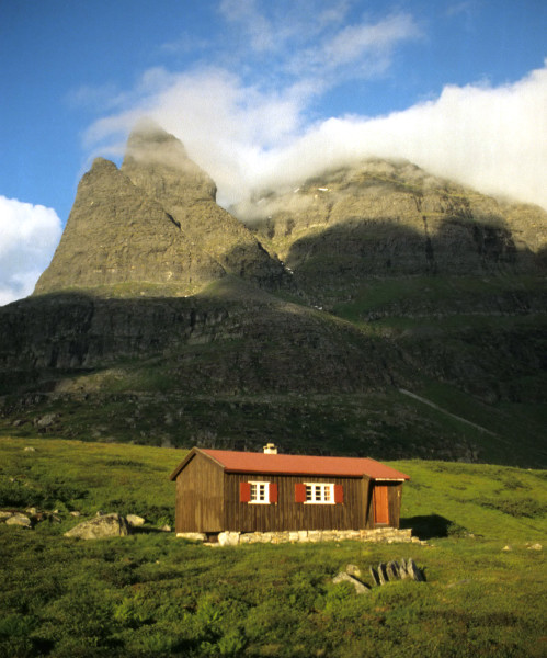
Innerdalstårnet or Dalatårnet is a tall mountain on the south side of the Innerdalen valley in Sunndal Municipality in Møre og Romsdal county, Norway. It is located about southeast of the village of Ålvundeid. The mountain is also known as the ''Matterhorn of Norway'' for its characteristic pyramidal shape. The summit can be reached with some scrambling, and the mountain is a very popular destination for rock climbing, several routes are established up the mountain.Klatrefører for Innerdalen, Norsk Tindeklubb The northern sub-peak, Litle Innerdalstårnet (seen in the picture) is slightly more inaccessible. Directly south of Innerdalstårnet are the mountains Tårnfjellet and Såtbakkollen, which is the second highest in Trollheimen Trollheimen is a mountain range in Møre og Romsdal and Trøndelag counties in central Norway. The mountain range is part of the Scandinavian Mountains. Etymology The name ('the home of the trolls') was proposed by Håkon Løken and us ... [...More Info...] [...Related Items...] OR: [Wikipedia] [Google] [Baidu] |
Gjevilvatnet
Gjevillvatnet (or ''Gjevilvatnet'') is a lake in the municipality of Oppdal in Trøndelag county, Norway. It is located in the Trollheimen mountain range, about south of the mountain Blåhøa and about northwest of the village of Vognillan. The lake was regulated for hydroelectric power-production in the 1970s. Water is tapped from the bottom in the western part of the lake, for use in the Driva power station. In the spring, the water level can be below the natural water level. The river Festa runs out of the lake Gjevillvatnet, and it was once a very good trout river from where the lake is now, all the way down to the intake dam at the old powerstation (Vardammen). This river now mostly runs dry every year due to the dam on Gjevillvatnet, and the trout are almost non-existent in the watercourse. The Gjevilvass valley is still regarded as one of Norway's most scenic valleys, and a cruise boat runs on the lake during summer. Along the middle of the lake, lies the ''Gjevillv ... [...More Info...] [...Related Items...] OR: [Wikipedia] [Google] [Baidu] |
Blåhøa
: ''For the mountain peak Blåhøi in Innlandet, Norway, see Blåhøi.'' : Blåhøa (or ''Blåhø'') is a mountain in the municipality of Oppdal in Trøndelag county, Norway. It is the highest mountain at the northeastern side of the Trollheimen mountain range. The mountain is located in the northwestern part of the municipality of Oppdal, about north of the lake Gjevillvatnet, about west of Nerskogen (in Rennebu), and about northwest of Vognillan. The tall mountain has a topographic prominence of . The Speilsalen glacial tunnel was located about northeast of the peak. Name The first element is ''blå'' which means "blue Blue is one of the three primary colours in the RYB colour model (traditional colour theory), as well as in the RGB (additive) colour model. It lies between violet and cyan on the spectrum of visible light. The eye perceives blue when ...", and the last element is ''hø(a)'' which means a "large and round mountain". References Oppdal ... [...More Info...] [...Related Items...] OR: [Wikipedia] [Google] [Baidu] |
Trollhetta
Trollhøtta or Trollhetta is a mountain on the border of Trøndelag and Møre og Romsdal counties in Norway. The tall mountain is located on the border of the municipalities of Surnadal (in Møre og Romsdal) and Rindal (in Trøndelag). It is part of the Trollheimen mountain range, just east of the lake Gråsjøen and the mountains Snota and Neådalssnota. To the south, across the valley ''Svartådalen'', you see the mountains ''Geithetta'' and ''Svarthetta''. The mountain has three peaks: the eastern peak is tall, the north one is and the south one is . You can access all three peaks during the summer, but a sharp and steep ridge between the eastern and northern peak is problematic in the winter for access from the east. The Norwegian Mountain Touring Association The Norwegian Trekking Association ( no, Den norske turistforening, DNT) is a Norwegian association which maintains mountain trails and cabins in Norway. The association was founded on 21 January 1868 with the ... [...More Info...] [...Related Items...] OR: [Wikipedia] [Google] [Baidu] |
Sunndal
is a municipality in the Nordmøre region located in the northeast part of Møre og Romsdal county, Norway. The administrative center of the municipality is the village of Sunndalsøra. Other villages include Gjøra, Grøa, Hoelsand, Jordalsgrenda, Romfo, Ålvund, Ålvundeidet, and Øksendalsøra. With an area of , it is the largest municipality in Møre og Romsdal county. The important occupations in Sunndal include industry (with Hydro Aluminium Sunndal as the biggest employer), public services, retail, and farming. The municipality is the 47th largest by area out of the 356 municipalities in Norway and it is the largest in Møre og Romsdal county. Sunndal is the 143rd most populous municipality in Norway with a population of 6,932. The municipality's population density is and its population has decreased by 3.7% over the previous 10-year period. General information The parish of Sunndal was established as a municipality on 1 January 1838 (see formannskapsdistrik ... [...More Info...] [...Related Items...] OR: [Wikipedia] [Google] [Baidu] |
Snota
Snota is a prominent mountain in the Trollheimen mountain range in the municipality of Surnadal in Møre og Romsdal county, Norway. It is also the highest mountain in the municipality of Surnadal. It lies west of the mountain Trollhetta and north of the mountain Neådalssnota. The peak is accessible from a parking lot by the lake Gråsjøen, from the cabin ''Trollheimshytta'' (owned by the Norwegian Mountain Touring Association The Norwegian Trekking Association ( no, Den norske turistforening, DNT) is a Norwegian association which maintains mountain trails and cabins in Norway. The association was founded on 21 January 1868 with the scope "to help and develop tourism i ...), and also from Vindøldalen/Vassdalen valley to the west (though less common). The main peak is tall and approximately to the north, there is the neighboring tall summit of ''Litjsnota''. The south wall of Snota is high and it was first climbed in 1994. The first winter ascent was in 1997. Below th ... [...More Info...] [...Related Items...] OR: [Wikipedia] [Google] [Baidu] |
Kongskrona
Kongskrona is a tall mountain peak in the municipality of Sunndal in Møre og Romsdal county, Norway. It is the higher of the two peaks on the main mountain Vinnufjellet. Its neighbouring peak is Dronningkrona, which is about shorter. The name means ''King's crown'' in Norwegian (the neighboring peak Dronningkrona means ''Queen's crown''). The peak lies about northeast of the village of Sunndalsøra. To the north of the mountain lies the Innerdalen valley. The top of the mountain is a glacier A glacier (; ) is a persistent body of dense ice that is constantly moving under its own weight. A glacier forms where the accumulation of snow exceeds its ablation over many years, often centuries. It acquires distinguishing features, such a ... called ''Vinnubreen'' or ''Vinnufonna''. References Mountains of Møre og Romsdal Sunndal {{MøreRomsdal-geo-stub ... [...More Info...] [...Related Items...] OR: [Wikipedia] [Google] [Baidu] |
Dronningkrona
Dronningkrona is a tall mountain peak in Sunndal Municipality in Møre og Romsdal county, Norway. It is one of the two peaks on the main mountain Vinnufjellet. Its neighbor peak is Kongskrona, which reaches higher. The peak is located just northeast of the village of Sunndalsøra and the Sunndalsfjorden Sunndalsfjorden (or just ''Sunndalsfjord'') is a fjord in Sunndal Municipality in Møre og Romsdal county, Norway. The long Sunndalsfjorden comprises the southern end of the main Tingvollfjorden. It begins at the Ballsneset peninsula, at the mu .... References Mountains of Møre og Romsdal Sunndal {{MøreRomsdal-geo-stub ... [...More Info...] [...Related Items...] OR: [Wikipedia] [Google] [Baidu] |
Oppdal
is a municipality in Trøndelag county, Norway. It is part of the Dovre region and the traditional district of Orkdalen. The administrative centre of the municipality is the village of Oppdal. Other villages in the municipality include Lønset, Vognillan, Fagerhaug, and Holan. The Oppdal Airport, Fagerhaug is located in the northeastern part of the municipality. The municipality is the 24th largest by area out of the 356 municipalities in Norway. Oppdal is the 139th most populous municipality in Norway with a population of 7,066. The municipality's population density is and its population has increased by 4.6% over the previous 10-year period. General information The prestegjeld of Oppdal was established as a municipality on 1 January 1838 (see formannskapsdistrikt law). The municipal boundaries have not changed since that time. On 1 January 2018, the municipality switched from the old Sør-Trøndelag county to the new Trøndelag county. Name The municipality (originally ... [...More Info...] [...Related Items...] OR: [Wikipedia] [Google] [Baidu] |
Gråsjøen
Gråsjøen is a lake/reservoir in the municipality of Surnadal in Møre og Romsdal county, Norway (and a very small part in the northeastern corner of the lake is in Rindal Municipality in Trøndelag county). The lake is located in the northern part of the Trollheimen mountain range. The lake is dammed and the water is used in the Gråsjø power station. The water flows out of the lake and into the lake Foldsjøen. Mount Snota lies just south of the lake. See also *List of lakes in Norway This is a list of lakes and reservoirs in Norway, sorted by county. For the geography and history of lakes in that country, see Lakes in Norway, including: * List of largest lakes in Norway * List of deepest lakes in Norway Akershus * Bjø ... References Rindal Surnadal Lakes of Trøndelag Lakes of Møre og Romsdal Reservoirs in Norway {{MøreRomsdal-geo-stub ... [...More Info...] [...Related Items...] OR: [Wikipedia] [Google] [Baidu] |


