|
Typhoon Durian
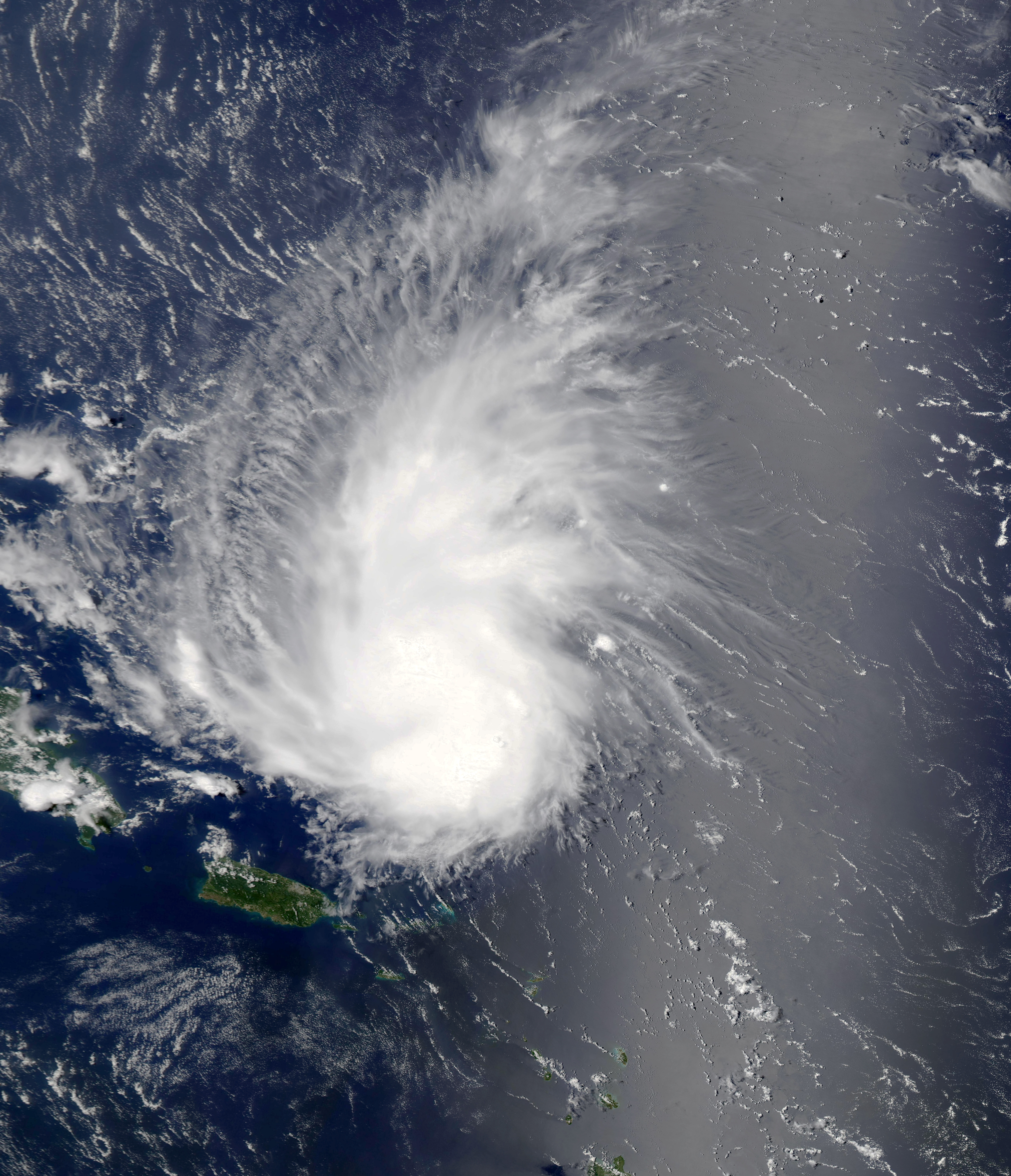
Typhoon Durian, known in the Philippines as Super Typhoon Reming, was a deadly tropical cyclone that wreaked havoc in the Philippines and later crossed the Malay Peninsula in late November 2006, causing massive loss of life when mudflows from the Mayon Volcano buried many villages. Durian first made landfall in the Philippines, packing strong winds and heavy rains that caused mudflows near Mayon Volcano. After causing massive damage in the Philippines, it exited into the South China Sea and weakened slightly, before managing to reorganise and restrengthen into a typhoon shortly before its second landfall, this time in Vietnam near Ho Chi Minh City, causing further damage of more than US$450 million. In all, Durian killed almost 2,000 people, and left hundreds more missing. Damages in the Philippines from the typhoon amounted to 5.086 billion PHP (US$130 million). Meteorological history The origins of Typhoon Durian can be traced to a tropical disturbance ... [...More Info...] [...Related Items...] OR: [Wikipedia] [Google] [Baidu] [Amazon] |
Yap State
Yap State ( or ) is one of the four states of the Federated States of Micronesia, located in the westernmost portion of the country. The state borders Palau to the southwest, Guam to the north, and Chuuk State to the east. According to the state's population census carried out in 2020, the total population is 11,577 residing across a total area of 119.54 sq km (46.15 sq mi), though a large majority of the area is water. The only town area in the state, Colonia, serves as the state capital. What is now current-day Yap State and some parts of Chuuk State were the historical Yapese Empire, which at its peak, controlled 1,300 km of the western Pacific comprising all the inhabited islands and atolls between Yap and Chuuk. The rulers of the chiefdom of Gagil in Yap maintained sovereignty of these islands to the east and extracted resources and tribute, maintaining close economic and political relationships with the different island groups. After losing its influence and becoming inc ... [...More Info...] [...Related Items...] OR: [Wikipedia] [Google] [Baidu] [Amazon] |
Tropical Wave
A tropical wave (also called easterly wave, tropical easterly wave, and African easterly wave), in and around the Atlantic Ocean, is a type of atmospheric trough, an elongated area of relatively low air pressure, oriented north to south, which moves from east to west across the tropics, causing areas of cloudiness and thunderstorms. Tropical waves form in the easterly flow along the equatorial side of the subtropical ridge or belt of high air pressure which lies north and south of the Intertropical Convergence Zone (ITCZ). Tropical waves are generally carried westward by the prevailing easterly winds along the tropics and subtropics near the equator. They can lead to the formation of tropical cyclones in the north Atlantic and northeastern Pacific basins. A tropical wave study is aided by Hovmöller diagrams, a graph of meteorological data. West-moving waves can also form from the tail end of frontal zones in the subtropics and tropics, and may be referred to as easterly ... [...More Info...] [...Related Items...] OR: [Wikipedia] [Google] [Baidu] [Amazon] |
Area Of Responsibility
Area of responsibility (AOR) is a pre-defined geographic region assigned to Combatant commanders of the Unified Command Plan (UCP), that are used to define an area with specific geographic boundaries where they have the authority to plan and conduct operations; for which a force, or component commander bears a certain responsibility. The term may also be used in other countries worldwide but it originated within the United States Armed Forces. This system is designed to allow a single commander to exercise command and control of all military forces in the AOR, regardless of their branch of service. George W. Bush signed the U.S. Unified Command Plan (UCP) 2008 on 17 December 2008, establishing the up-to-date boundaries for the newest Command, United States Africa Command (USAFRICOM), and all changes to boundaries of the other Commands.DefenseLINK-Unified Command Plan"The World with Commanders' Area of Responsibility". Retrieved 29 December 2009. U.S. Unified Command Plan (UCP ... [...More Info...] [...Related Items...] OR: [Wikipedia] [Google] [Baidu] [Amazon] |
Philippine Atmospheric, Geophysical And Astronomical Services Administration
The Philippine Atmospheric, Geophysical and Astronomical Services Administration (, abbreviated as PAGASA , which means "hope" as in the Tagalog word ''pag-asa'') is the National Meteorological and Hydrological Services (NMHS) agency of the Philippines mandated to provide protection against natural calamities and to ensure the safety, well-being and economic security of all the people, and for the promotion of national progress by undertaking scientific and technological services in meteorology, hydrology, climatology, astronomy and other geophysical sciences. Created on December 8, 1972, by reorganizing the Weather Bureau, PAGASA now serves as one of the Scientific and Technological Services Institutes of the Department of Science and Technology. History The ''Observatorio Meteorológico de Manila'' Formal meteorological and astronomical services in the Philippines began in 1865 with the establishment of the ''Observatorio Meteorológico de Manila'' (Manila Meteorologica ... [...More Info...] [...Related Items...] OR: [Wikipedia] [Google] [Baidu] [Amazon] |
Philippine Sea
The Philippine Sea is a List of seas#Marginal seas by ocean, marginal sea of the Pacific Ocean, Western Pacific Ocean east of the list of islands of the Philippines, Philippine Archipelago (hence the name) and the List of seas#Largest seas by area, largest sea in the world, occupying an estimated surface area of . The Philippine Sea Plate forms the floor of the sea. Its western border is the first island chain to the west, comprising the Ryukyu Islands in the northwest and Taiwan in the west. Its southwestern border comprises the Philippines, Philippine islands of Luzon, Catanduanes, Samar, Leyte, and Mindanao. Its northern border comprises the Japanese islands of Honshu, Shikoku and Kyūshū. Its eastern border is the second island chain to the east, comprising the Bonin Islands and Iwo Jima in the northeast, the Mariana Islands (including Guam, Saipan, and Tinian) in the due east, and Halmahera, Palau, Yap and Ulithi (of the Caroline Islands) in the southeast. Its southern ... [...More Info...] [...Related Items...] OR: [Wikipedia] [Google] [Baidu] [Amazon] |
Durian
The durian () is the edible fruit of several tree species belonging to the genus ''Durio''. There are 30 recognized species, at least nine of which produce edible fruit. ''Durio zibethinus'', native to Borneo and Sumatra, is the only species available on the international market. It has over 300 named varieties in Thailand and over 200 in Malaysia as of 2021. Other species are sold in their local regions. Known in some regions as the "king of fruits", the durian is distinctive for its large size, strong odour, and Spine (botany), thorn-covered peel (fruit), rind. The fruit can grow as large as long and in diameter, and it typically weighs . Its shape ranges from oblong to round, the colour of its husk from green to brown, and its flesh from pale yellow to red, depending on the species. Some people regard the durian as having a pleasantly sweet fragrance, whereas others find the aroma overpowering and unpleasant. The persistence of its strong odour, which may linger for sev ... [...More Info...] [...Related Items...] OR: [Wikipedia] [Google] [Baidu] [Amazon] |
World Meteorological Organization
The World Meteorological Organization (WMO) is a List of specialized agencies of the United Nations, specialized agency of the United Nations responsible for promoting international cooperation on atmospheric science, climatology, hydrology and geophysics. The WMO originated from the International Meteorological Organization (IMO), a nongovernmental organization founded in 1873 as a forum for exchanging weather data and research. Proposals to reform the status and structure of the IMO culminated in the World Meteorological Convention of 1947, which formally established the World Meteorological Organization. The Convention entered into force on 23 March 1950, and the following year the WMO began operations as an intergovernmental organization within the UN system. The WMO is made up of 193 countries and territories, and facilitates the "free and unrestricted" exchange of data, information, and research between the respective meteorological and hydrological institutions of its m ... [...More Info...] [...Related Items...] OR: [Wikipedia] [Google] [Baidu] [Amazon] |
Tropical Cyclone Naming
Tropical cyclones and subtropical cyclones are named by various warning centers to simplify communication between forecasters and the general public regarding forecasts, watches and warnings. The names are intended to reduce confusion in the event of concurrent storms in the same Tropical cyclone basins, basin. Once storms develop sustained wind speeds of more than , names are generally assigned to them from predetermined lists, depending on the basin in which they originate. Some tropical depressions are named in the Western Pacific, while tropical cyclones must contain a significant amount of gale-force winds before they are named in the Southern Hemisphere. Before it became standard practice to give Given name, personal (first) names to tropical cyclones, they were named after places, objects, or the saints' feast days on which they occurred. Credit for the first usage of personal names for weather systems is generally given to Queensland Government meteorologist Clement Wr ... [...More Info...] [...Related Items...] OR: [Wikipedia] [Google] [Baidu] [Amazon] |
Ridge (meteorology)
In meteorology a ridge or barometric ridge is an elongated area of relatively high atmospheric pressure compared to the surrounding environment, without being a closed circulation. It is associated with an area of maximum anticyclonic curvature of wind flow. The ridge originates in the center of an anticyclone and sandwiched between two low-pressure areas, and the locus of the maximum curvature is called the ''ridge line''. This phenomenon is the opposite of a trough. Description Ridges can be represented in two ways: * On surface weather maps, the pressure isobars form contours where the maximum pressure is found along the axis of the ridge. * In upper-air maps, geopotential height isohypses form similar contours where the maximum defines the ridge. Related weather Given the direction of the winds around an anticyclonic circulation and the fact that weather systems move from west to east: *ahead of an upper-ridge, the airflow that comes from the polar regions and bri ... [...More Info...] [...Related Items...] OR: [Wikipedia] [Google] [Baidu] [Amazon] |
Regional Specialized Meteorological Center
A Regional Specialized Meteorological Centre (RSMC) is responsible for the distribution of information, advisories, and warnings regarding the specific program they have a part of, agreed by consensus at the World Meteorological Organization as part of the World Weather Watch. Environmental emergency response programme As a result of the poor communications between countries following the Chernobyl disaster in the Spring of 1986, the World Meteorological Organization (WMO) was requested by the International Atomic Energy Agency (IAEA) and other international organizations to arrange for early warning messages about nuclear accidents to be transmitted over the Global Telecommunications System (GTS). In addition some WMO member countries that lacked extensive forecasting capability requested that specialized pollutant transport and dispersion forecasts be provided during these emergencies. As a result, during 1989 Meteo-France (MF), Environment Canada (EC) and the United Kingdom ... [...More Info...] [...Related Items...] OR: [Wikipedia] [Google] [Baidu] [Amazon] |
Japan Meteorological Agency
The Japan Meteorological Agency (JMA; ''気象庁, Kishō-chō'') is a division of the Ministry of Land, Infrastructure, Transport and Tourism dedicated to the Scientific, scientific observation and research of natural phenomena. Headquartered in Minato, Tokyo the government agency, agency collects data on meteorology, hydrology, seismology, volcanology, and other related fields. The JMA is responsible for collecting and disseminating weather data and Forecasting, forecasts to the public, as well as providing specialized information for aviation and Marine weather forecasting, marine sectors. Additionally, the JMA issues warnings for volcanic eruptions and is integral to the nationwide Earthquake Early Warning (Japan), Earthquake Early Warning (EEW) system. As one of the Regional Specialized Meteorological Centers designated by the World Meteorological Organization (WMO), the JMA also Forecasting, forecasts, Tropical cyclone naming, names, and distributes warnings for tropical ... [...More Info...] [...Related Items...] OR: [Wikipedia] [Google] [Baidu] [Amazon] |
Coordinated Universal Time
Coordinated Universal Time (UTC) is the primary time standard globally used to regulate clocks and time. It establishes a reference for the current time, forming the basis for civil time and time zones. UTC facilitates international communication, navigation, scientific research, and commerce. UTC has been widely embraced by most countries and is the effective successor to Greenwich Mean Time (GMT) in everyday usage and common applications. In specialised domains such as scientific research, navigation, and timekeeping, other standards such as Universal Time, UT1 and International Atomic Time (TAI) are also used alongside UTC. UTC is based on TAI (International Atomic Time, abbreviated from its French name, ''temps atomique international''), which is a weighted average of hundreds of atomic clocks worldwide. UTC is within about one second of mean solar time at 0° longitude, the currently used prime meridian, and is not adjusted for daylight saving time. The coordination of t ... [...More Info...] [...Related Items...] OR: [Wikipedia] [Google] [Baidu] [Amazon] |


