|
Tureia
Tureia (also called Papahena) is an atoll in the Tuamotu Archipelago in French Polynesia. Tureia atoll is 15 km long and has a maximum width of ; its total land area is 8 km2. A very long island covers completely its eastern reef. The lagoon has no navigable entrance. The village of Hakamaru (or Fakamaru) is the only settlement on Tureia, at the northern tip of the atoll. Almost all of the arable land on Tureia is dedicated to growing coconuts. The population in this atoll has risen to 275 in 2017; in 1977 there were only 121 inhabitants. History The first recorded European to arrive at Tureia was Captain Edward Edwards in 1791, during his search for the Bounty mutineers. Edwards called the atoll "Carysfort", after John Proby, 1st Earl of Carysfort. From 1966 to 1999, Tureia hosted an outpost of the ''Centre d'Expテゥrimentation du Pacifique'', the French authority supervising nuclear tests on the nearby atolls of Moruroa and Fangataufa, which lie about 115 km south ... [...More Info...] [...Related Items...] OR: [Wikipedia] [Google] [Baidu] |
Tureia Airport
Tureia Airport is an airport on Tureia in French Polynesia . Tureia Airport An airport is an aerodrome with extended facilities, mostly for commercial air transport. Airports usually consists of a landing area, which comprises an aerially accessible open space including at least one operationally active surfa ... was inaugurated in 1985. Airlines and destinations Passenger No scheduled flights as of May 2019. Statistics References Airports in French Polynesia {{FrenchPolynesia-geo-stub ... [...More Info...] [...Related Items...] OR: [Wikipedia] [Google] [Baidu] |
Vanavana
Vanavana, Kurataki, or Huataki is an atoll in the southeastern area of the Tuamotu Archipelago, French Polynesia. Vanavana's nearest neighbour is Tureia, which is located to the east. Vanavana is a small oval-shaped atoll. It measures approximately in length, has a maximum width of and a land area of approximately . Its reef encloses completely the deep lagoon, which is . There is one hook-shaped large island in the north and another in the south of its reef. Vanavana Atoll is uninhabited; however, buildings on the northern end of the island are present. History The first recorded European to arrive at Vanavana was British mariner Captain Frederick Beechey in 1826. He named this atoll "Barrow Island", after Sir John Barrow. Administration Administratively Vanavana Atoll belongs to the commune of Tureia, which includes the atolls of Tureia, Fangataufa, Moruroa Moruroa (Mururoa, Mururura), also historically known as Aopuni, is an atoll which forms part of the Tuamotu Ar ... [...More Info...] [...Related Items...] OR: [Wikipedia] [Google] [Baidu] |
Tuamotus
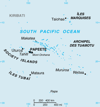
The Tuamotu Archipelago or the Tuamotu Islands (french: テ四es Tuamotu, officially ) are a French Polynesian chain of just under 80 islands and atolls in the southern Pacific Ocean. They constitute the largest chain of atolls in the world, extending (from northwest to southeast) over an area roughly the size of Western Europe. Their combined land area is . This archipelago's major islands are Anaa, Fakarava, Hao and Makemo. The Tuamotus have approximately 16,000 inhabitants. The islands were initially settled by Polynesians, and modern Tuamotuans have inherited from them a shared culture and the Tuamotuan language. The Tuamotus are a French overseas collectivity. History The early history of the Tuamotu islands is generally unknown. Archaeological findings suggest that the western Tuamotus were settled from the Society Islands as early as 900 CE or as late as 1200 CE. DNA evidence suggests that they were settled about 1110 CE. On the islands of Rangiroa, Manihi and M ... [...More Info...] [...Related Items...] OR: [Wikipedia] [Google] [Baidu] |
Tematangi
Tematagi or TematangiBoard of Geographical Names Site Internet: http://geonames.usgs.gov/foreign/index.html is an atoll in the southeastern area of the Tuamotu Archipelago, French Polynesia. Tematagi's nearest neighbour is Mururoa, which is located to the ESE. Tematagi is a medium-sized atoll. It measures approximately in length and has a maximum width of with a land area of almost . As its reef completely encloses the deep lagoon, which is , there is no navigable pass to enter the lagoon. There are many relatively large islands on Tematagi's reef, as well as a few small motu. The main village is Tuihana. There were 58 inhabitants on Tematagi in the last census. History The first recorded European to visit this atoll was Captain William Bligh on the ship ''Providence'' on April 5, 1792. At the time of Bligh's visit, it was uninhabited. Tematagi Atoll appears in some maps as "Bligh's Lagoon Island". When Frederick Beechey visited Tematagi in 1826 he found inhabitants there. ... [...More Info...] [...Related Items...] OR: [Wikipedia] [Google] [Baidu] |
Fangataufa
Fangataufa (or Fangatafoa) is an uninhabited coral atoll in the eastern part of the Tuamotu Archipelago in French Polynesia. The atoll has been fully-owned by the French state since 1964. From 1966 to 1996 it was used as a nuclear test site by the French government. In total, 4 atmospheric and 10 underground nuclear explosions were carried out on the atoll. Geography The atoll is a coral outgrowth of a seamount which rises some from the seafloor, to a depth of . The seamount was formed 33.4 - 34.7 million years ago by the Pitcairn hotspot. The island is approx. long and wide. It has a lagoon area of and a land area of . It is located south of Moruroa atoll, east of Tematangi, southwest of the Gambier Islands and southeast of Tahiti. Access to the lagoon is through a pass lying SW of the northernmost point of the atoll; the channel has a width of about and a dredged depth of . A quay, in of water, is situated in the NE part of the lagoon; another quay, long in of wat ... [...More Info...] [...Related Items...] OR: [Wikipedia] [Google] [Baidu] |
Moruroa
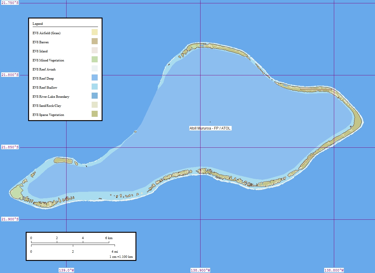
Moruroa (Mururoa, Mururura), also historically known as Aopuni, is an atoll which forms part of the Tuamotu Archipelago in French Polynesia in the southern Pacific Ocean. It is located about southeast of Tahiti. Administratively Moruroa Atoll is part of the commune of Tureia, which includes the atolls of Tureia, Fangataufa, Tematangi and Vanavana. France undertook nuclear weapon tests between 1966 and 1996 at Moruroa and Fangataufa, causing international protests, notably in 1974 and 1995. The number of tests performed on Moruroa has been variously reported as 175 and 181. History Ancient Polynesians knew Mururoa Atoll by the ancestral name of Hiti-Tautau-Mai. The first recorded European to visit this atoll was Commander Philip Carteret on HMS ''Swallow'' in 1767, just a few days after he had discovered Pitcairn Island. Carteret named Mururoa "Bishop of Osnaburgh Island". In 1792, the British whaler was wrecked here, and it became known as Matilda's Rocks. Frederick Will ... [...More Info...] [...Related Items...] OR: [Wikipedia] [Google] [Baidu] |
テ四es Tuamotu-Gambier
The テ四es Tuamotu-Gambier (french: テ四es Tuamotu-Gambier or ''Archipels des Tuamotu et des Gambier'' or ''Archipel des Tuamotu-Gambier'' or ''Tuamotu-Gambier'' or officially ''subdivision administrative des (テ四es) Tuamotu-Gambier'') is an administrative division in French Polynesia. It consists of the Tuamotus and the Gambier Islands which are geographically located closely together. Because of a difference between administrative districts and electoral circumscriptions on the テ四es Tuamotu-Gambier, French Polynesia has 5 administrative subdivisions (french: subdivisions administratives), but 6 electoral districts/electoral circumscriptions (french: circonscriptions テゥlectorales). It has an area of 726.5 square kilometers and an estimated population of 16,881 people according to data from 2017. Administrative division Administratively, the テ四es Tuamotu-Gambier form one of the 5 administrative subdivisions (''subdivision administratives'') of French Polynesia, the administrativ ... [...More Info...] [...Related Items...] OR: [Wikipedia] [Google] [Baidu] |
Pacific Ocean
The Pacific Ocean is the largest and deepest of Earth's five oceanic divisions. It extends from the Arctic Ocean in the north to the Southern Ocean (or, depending on definition, to Antarctica) in the south, and is bounded by the continents of Asia and Oceania in the west and the Americas in the east. At in area (as defined with a southern Antarctic border), this largest division of the World Ocean窶蚤nd, in turn, the hydrosphere窶把overs about 46% of Earth's water surface and about 32% of its total surface area, larger than Earth's entire land area combined .Pacific Ocean . '' Britannica Concise.'' 2008: Encyclopテヲdia Britannica, Inc. The centers of both the [...More Info...] [...Related Items...] OR: [Wikipedia] [Google] [Baidu] |
Lテゥgifrance
Lテゥgifrance is the official website of the French government for the publication of legislation, regulations, and legal information. Access to the site is free. Virtually complete, it presents or refers to all concerned institutions or administrations, all texts still in force since 1539 and all the upper courts jurisprudence since 1986 as well as the most pertinent one of all courts since 1875. C.E. 19 February 1875, Prince Napolテゥon, 46707. See also *References ''All texts in French unless otherwise noted.''[...More Info...] [...Related Items...] OR: [Wikipedia] [Google] [Baidu] |
Commune Of France
The () is a level of administrative division in the French Republic. French are analogous to civil townships and incorporated municipalities in the United States and Canada, ' in Germany, ' in Italy, or ' in Spain. The United Kingdom's equivalent are civil parishes, although some areas, particularly urban areas, are unparished. are based on historical geographic communities or villages and are vested with significant powers to manage the populations and land of the geographic area covered. The are the fourth-level administrative divisions of France. vary widely in size and area, from large sprawling cities with millions of inhabitants like Paris, to small hamlets with only a handful of inhabitants. typically are based on pre-existing villages and facilitate local governance. All have names, but not all named geographic areas or groups of people residing together are ( or ), the difference residing in the lack of administrative powers. Except for the municipal arrondi ... [...More Info...] [...Related Items...] OR: [Wikipedia] [Google] [Baidu] |
Weather Station
A weather station is a facility, either on land or sea, with instruments and equipment for measuring atmospheric conditions to provide information for weather forecasts and to study the weather and climate. The measurements taken include temperature, atmospheric pressure, humidity, wind speed, wind direction, and precipitation amounts. Wind measurements are taken with as few other obstructions as possible, while temperature and humidity measurements are kept free from direct solar radiation, or insolation. Manual observations are taken at least once daily, while automated measurements are taken at least once an hour. Weather conditions out at sea are taken by ships and buoys, which measure slightly different meteorological quantities such as sea surface temperature (SST), wave height, and wave period. Drifting weather buoys outnumber their moored versions by a significant amount. Weather instruments Typical weather stations have the following instruments: * Thermomete ... [...More Info...] [...Related Items...] OR: [Wikipedia] [Google] [Baidu] |


.jpg)
