|
Tunitas, California
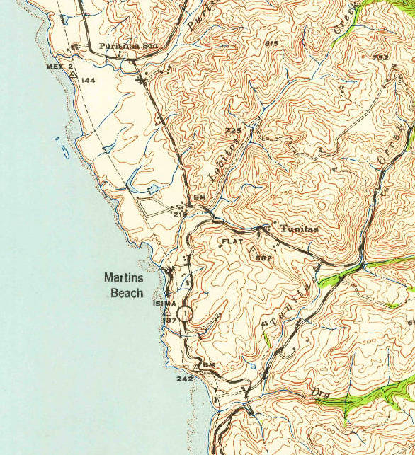
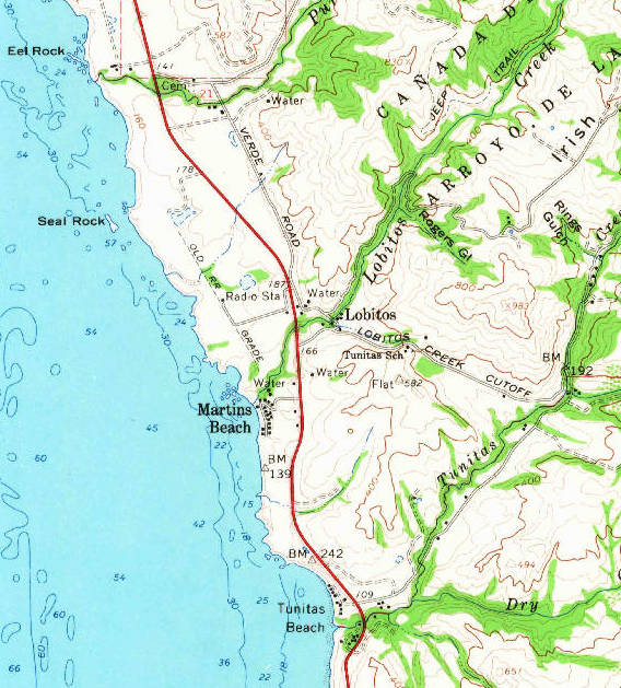
Tunitas, California was a small unincorporated community in San Mateo County, California, San Mateo County. It was originally located on California State Route 1, State Route 1 until that state route was moved to the west. It was also renamed Lobitos, California, Lobitos. ''Arroyo de las Tunitas'' is shown on the ''diseños'', about 1839, of the Rancho San Gregorio, San Gregorio and Rancho Cañada de Verde y Arroyo de la Purisima, Canada Verde grants. The name means “A small bush…grows super-abundant at and near its mouth, and its fruit is known to the present generation as sea apples.” References [...More Info...] [...Related Items...] OR: [Wikipedia] [Google] [Baidu] |
Ghost Town
Ghost Town(s) or Ghosttown may refer to: * Ghost town, a town that has been abandoned Film and television * ''Ghost Town'' (1936 film), an American Western film by Harry L. Fraser * ''Ghost Town'' (1956 film), an American Western film by Allen H. Miner * ''Ghost Town'' (1988 film), an American horror film by Richard McCarthy (as Richard Governor) * ''Ghost Town'' (2008 film), an American fantasy comedy film by David Koepp * ''Ghost Town'', a 2008 TV film featuring Billy Drago * '' Derek Acorah's Ghost Towns'', a 2005–2006 British paranormal reality television series * "Ghost Town" (''CSI: Crime Scene Investigation''), a 2009 TV episode Literature * ''Ghost Town'' (''Lucky Luke'') or ''La Ville fantôme'', a 1965 ''Lucky Luke'' comic *''Ghost Town'', a Beacon Street Girls novel by Annie Bryant *''Ghost Town'', a 1998 novel by Robert Coover *''Ghosttown'', a 2007 novel by Douglas Anne Munson Music * Ghost Town (band), an American electronic band * ''Ghost Town'', a 19 ... [...More Info...] [...Related Items...] OR: [Wikipedia] [Google] [Baidu] |
Geographic Names Information System
The Geographic Names Information System (GNIS) is a database of name and locative information about more than two million physical and cultural features throughout the United States and its territories, Antarctica, and the associated states of the Marshall Islands, Federated States of Micronesia, and Palau. It is a type of gazetteer. It was developed by the United States Geological Survey (USGS) in cooperation with the United States Board on Geographic Names (BGN) to promote the standardization of feature names. Data were collected in two phases. Although a third phase was considered, which would have handled name changes where local usages differed from maps, it was never begun. The database is part of a system that includes topographic map names and bibliographic references. The names of books and historic maps that confirm the feature or place name are cited. Variant names, alternatives to official federal names for a feature, are also recorded. Each feature receives ... [...More Info...] [...Related Items...] OR: [Wikipedia] [Google] [Baidu] |
Rancho San Gregorio
Rancho San Gregorio was a Mexican land grant in present day San Mateo County, California given in 1839 by Governor Juan Alvarado to Antonio Buelna. At the time, the grant was in Santa Cruz County; an 1868 boundary adjustment gave the land to San Mateo County. The rancho extended from Tunitas Creek in the north to the mouth of Pomponio Creek and encompassed San Gregorio, California, San Gregorio State Beach and La Honda History Antonio Jose Buelna (1790–1846), son of José Antonio Buelna (1754–1821) married Maria Concepción Valencia (b.1798) in 1816. In 1836, José Castro, Juan Alvarado, Antonio Buelna, and José Antonio de la Guerra (son José de la Guerra y Noriega) signed the demand that Governor Nicolás Gutiérrez resign. In addition to the four square league Rancho San Gregorio grant, Alvarado granted Antonio Buelna Rancho San Francisquito in Santa Clara County in 1839. Buelna built a road, known today as La Honda Road and Old La Honda Road, over the ... [...More Info...] [...Related Items...] OR: [Wikipedia] [Google] [Baidu] |
Lobitos, California
Lobitos (Spanish for "Little wolves") is a populated place in San Mateo County, just east of State Route 1 and south of Half Moon Bay and the ghost town of Purissima. It is above sea level. Name Lobitos means 'little wolves', a nickname for 'otters' in Spanish. It was originally named " Tunitas". History The Ocean Shore Railroad, which operated between San Francisco and Tunitas Creek from 1907 to 1920, passed near the village. There was apparently no station in Lobitos. Highway 1 originally passed through Lobitos; it was later rerouted to the west of the village, closely following the old railroad route. Today, the portion of the former state highway through Lobitos has become Verde Road. The Lobitos Creek Cut-Off connects the village with Tunitas Creek Road, which runs between Highway 1 and State Route 35 (Skyline Boulevard A skyline is the outline or shape viewed near the horizon. It can be created by a city’s overall structure, or by human intervention in a ... [...More Info...] [...Related Items...] OR: [Wikipedia] [Google] [Baidu] |
California State Route 1
State Route 1 (SR 1) is a major north–south state highway that runs along most of the Pacific coastline of the U.S. state of California. At , it is the longest state route in California, and the second-longest in the US after Montana Highway 200. SR 1 has several portions designated as either Pacific Coast Highway (PCH), Cabrillo Highway, Shoreline Highway, or Coast Highway. Its southern terminus is at Interstate 5 (I-5) near Dana Point in Orange County and its northern terminus is at U.S. Route 101 (US 101) near Leggett in Mendocino County. SR 1 also at times runs concurrently with US 101, most notably through a stretch in Ventura and Santa Barbara counties, and across the Golden Gate Bridge. The highway is designated as an All-American Road. In addition to providing a scenic route to numerous attractions along the coast, the route also serves as a major thoroughfare in the Greater Los Angeles Area, the San Francisco Bay Area, and seve ... [...More Info...] [...Related Items...] OR: [Wikipedia] [Google] [Baidu] |
OSRR With Lobitos And Tunitas Stations
Ohio Southern Railroad is a railroad owned by Genesee & Wyoming Inc. It begins in Zanesville, Ohio along the intersections of Ohio Central Railroad and Columbus and Ohio River Railroad which are both also owned by Genesee & Wyoming. The other end of the line is in New Lexington, Ohio, with trackage rights on the Kanawha River Railroad (formerly Norfolk Southern) to South Glouster, Ohio. The company was acquired by Genesee & Wyoming in 2008 as part of its purchase of the Ohio Central Railroad System The Ohio Central Railroad System is a network of ten short line railroads operating in Ohio and western Pennsylvania. It is owned by Genesee & Wyoming Headquartered in Coshocton, Ohio, the system operates of track divided among 10 subsidiary r .... References External links Ohio Southern Railroad official webpage - Genesee and Wyoming website*https://web.archive.org/web/20050922213322/http://www.michiganrailroads.com/RRHX/Stories/DT%26I-TheRailroadThatWentNoPlacePart1.htm *htt ... [...More Info...] [...Related Items...] OR: [Wikipedia] [Google] [Baidu] |
Federal Information Processing Standard
The Federal Information Processing Standards (FIPS) of the United States are a set of publicly announced standards that the National Institute of Standards and Technology (NIST) has developed for use in computer systems of non-military, American government agencies and contractors. FIPS standards establish requirements for ensuring computer security and interoperability, and are intended for cases in which suitable industry standards do not already exist. Many FIPS specifications are modified versions of standards the technical communities use, such as the American National Standards Institute (ANSI), the Institute of Electrical and Electronics Engineers (IEEE), and the International Organization for Standardization (ISO). Specific areas of FIPS standardization The U.S. government has developed various FIPS specifications to standardize a number of topics including: * Codes, e.g., FIPS county codes or codes to indicate weather conditions or emergency indications. In 1994, N ... [...More Info...] [...Related Items...] OR: [Wikipedia] [Google] [Baidu] |
List Of Sovereign States
The following is a list providing an overview of sovereign states around the world with information on their status and recognition of their sovereignty. The 206 listed states can be divided into three categories based on membership within the United Nations System: 193 member states of the United Nations, UN member states, 2 United Nations General Assembly observers#Present non-member observers, UN General Assembly non-member observer states, and 11 other states. The ''sovereignty dispute'' column indicates states having undisputed sovereignty (188 states, of which there are 187 UN member states and 1 UN General Assembly non-member observer state), states having disputed sovereignty (16 states, of which there are 6 UN member states, 1 UN General Assembly non-member observer state, and 9 de facto states), and states having a political status of the Cook Islands and Niue, special political status (2 states, both in associated state, free association with New Zealand). Compi ... [...More Info...] [...Related Items...] OR: [Wikipedia] [Google] [Baidu] |
Pacific Time Zone
The Pacific Time Zone (PT) is a time zone encompassing parts of western Canada, the western United States, and western Mexico. Places in this zone observe standard time by subtracting eight hours from Coordinated Universal Time ( UTC−08:00). During daylight saving time, a time offset of UTC−07:00 is used. In the United States and Canada, this time zone is generically called the Pacific Time Zone. Specifically, time in this zone is referred to as Pacific Standard Time (PST) when standard time is being observed (early November to mid-March), and Pacific Daylight Time (PDT) when daylight saving time (mid-March to early November) is being observed. In Mexico, the corresponding time zone is known as the ''Zona Noroeste'' (Northwest Zone) and observes the same daylight saving schedule as the U.S. and Canada. The largest city in the Pacific Time Zone is Los Angeles, whose metropolitan area is also the largest in the time zone. The zone is two hours ahead of the Hawaii–Ale ... [...More Info...] [...Related Items...] OR: [Wikipedia] [Google] [Baidu] |


