|
Tumu, Ghana
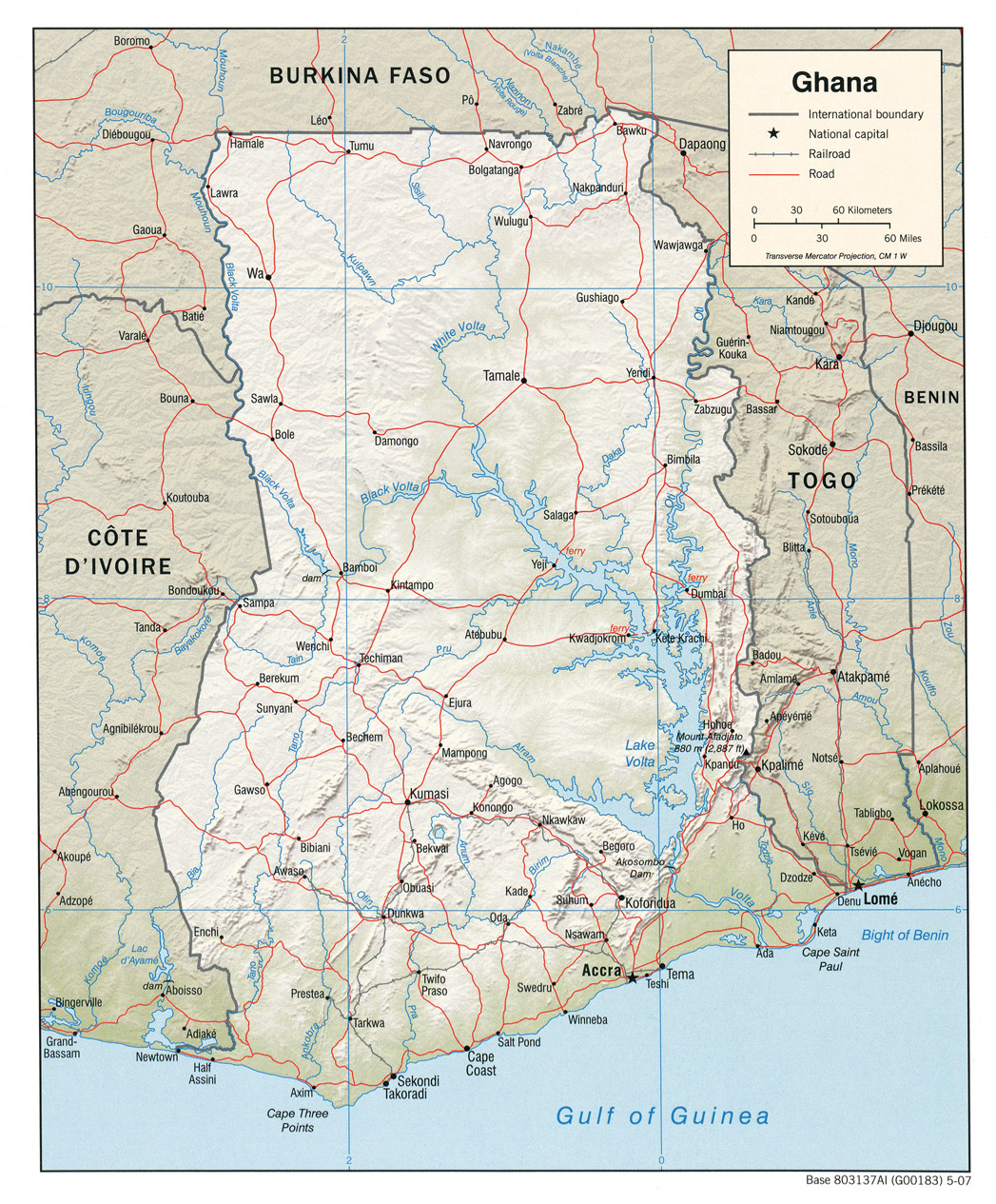
Tumu is a small town and is the capital of Sissala East district, a district in the Upper West Region of north Ghana, adjacent to the border with Burkina Faso.Sissala East District Tumu is connected by road to the town of Navrongo. Tumu is the nearest town to Gbele Resource Centre
The Gbele Resource Centre or Gbele Game Production Reserve is one of the lesser known game reserves in Ghana. It is located in the Sissala West, Sissala East Municipal and Daffiama Bussie Issa districts of the Upper West Region The reserve is ... , the fourth largest ...
[...More Info...] [...Related Items...] OR: [Wikipedia] [Google] [Baidu] |
Municipal
A municipality is usually a single administrative division having corporate status and powers of self-government or jurisdiction as granted by national and regional laws to which it is subordinate. The term ''municipality'' may also mean the governing body of a given municipality. A municipality is a general-purpose administrative subdivision, as opposed to a special-purpose district. The term is derived from French and Latin . The English word ''municipality'' derives from the Latin social contract (derived from a word meaning "duty holders"), referring to the Latin communities that supplied Rome with troops in exchange for their own incorporation into the Roman state (granting Roman citizenship to the inhabitants) while permitting the communities to retain their own local governments (a limited autonomy). A municipality can be any political jurisdiction, from a sovereign state such as the Principality of Monaco, to a small village such as West Hampton Dunes, New Yo ... [...More Info...] [...Related Items...] OR: [Wikipedia] [Google] [Baidu] |
Upper West Region
The Upper West Region of Ghana is located in the north-western corner of Ghana and is bordered by Upper East region to the east, Northern region to the south, and Burkina Faso to the west and north. The Upper West regional capital and largest settlement is Wa. The Upper West was created by the then Head of State, Flight-Lieutenant Jerry Rawlings in 1983 under the Provisional National Defense Council (PNDC) military regime. The area was carved out of the former Upper Region, which is now the Upper East Region. For about thirty-five years, it remained the youngest region of Ghana until 2018 when six more regions were created by the Nana Addo Dankwa Akufo-Addo government; hence increasing the total number of administrative regions in the country to sixteen. Geography and climate Location and size The Upper West Region is one of the 16 regions of Ghana. It is located at the North Western corner of Ghana with latitude 9.8°- 11.O° North and longitude 1.6°- 3.0 West, bounded to Bu ... [...More Info...] [...Related Items...] OR: [Wikipedia] [Google] [Baidu] |
Ghana
Ghana (; tw, Gaana, ee, Gana), officially the Republic of Ghana, is a country in West Africa. It abuts the Gulf of Guinea and the Atlantic Ocean to the south, sharing borders with Ivory Coast in Ghana–Ivory Coast border, the west, Burkina Faso in Burkina Faso–Ghana border, the north, and Togo in Ghana–Togo border, the east.Jackson, John G. (2001) ''Introduction to African Civilizations'', Citadel Press, p. 201, . Ghana covers an area of , spanning diverse biomes that range from coastal savannas to tropical rainforests. With nearly 31 million inhabitants (according to 2021 census), Ghana is the List of African countries by population, second-most populous country in West Africa, after Nigeria. The capital and List of cities in Ghana, largest city is Accra; other major cities are Kumasi, Tamale, Ghana, Tamale, and Sekondi-Takoradi. The first permanent state in present-day Ghana was the Bono state of the 11th century. Numerous kingdoms and empires emerged over the centuri ... [...More Info...] [...Related Items...] OR: [Wikipedia] [Google] [Baidu] |
Sissala East Municipal
{{dab ...
Sissala may be, *Sissala East District, Ghana *Sissala West District *Sissala language Sisaala (''Sissala'') is a Gur language cluster spoken in northern Ghana near the town of TumuEdited by M.E.Kropp Dakubu, ''The Languages of Ghana'', Kegan Paul International, 1988. and in the neighbouring republic of Burkina Faso. Western Sisa ... [...More Info...] [...Related Items...] OR: [Wikipedia] [Google] [Baidu] |
Sissala East District
Sissala East Municipal District is one of the eleven districts in Upper West Region, Ghana. Originally it was formerly part of the then-larger Sissala District in 1988; until the western part of the district was later split off to create Sissala West District in July 2004; thus the remaining part has been renamed as Sissala East District, which it was later elevated to municipal district assembly status on 15 March 2018 to become Sissala East Municipal District. The municipality is located in the northeast/eastern part of Upper West Region and has Tumu as its capital town. Populated places * Chato * Pudo Pudo is a town in Sissala East Municipal District, Upper West Region in northern Ghana near the border with Burkina Faso. Mining Historically, the Pudo area has been a significant source of ironware. Pudo is near significant unexploited iron ... * Saiye * Tumu Sources * References {{coord, 10, 52, 22, N, 1, 58, 49, W, region:GH, display=title Sissala East Mu ... [...More Info...] [...Related Items...] OR: [Wikipedia] [Google] [Baidu] |
Burkina Faso–Ghana Border
The Burkina Faso–Ghana border is 602 km (374 m) in length and runs from the tripoint with Ivory Coast in the west to the tripoint with Togo in the east. Description The border starts in the west at the tripoint with Ivory Coast on the Black Volta river; the border continues north along this river up to the 11th parallel north. The border then turns east, following this parallel until it reaches the Red Volta (though note that the border is not entirely straight in this sector, as at several points the boundary jogs north or south). The border follows the Red Volta briefly to the south-east, before turning to the north-east via a series of irregular overland lines. It then reaches the White Volta, following this river briefly, and then the Nouhao, before it turns to the south-east in a straight line down to the Togolese tripoint. History Europeans had begun exploring the coast of Ghana (then referred to as the Gold Coast) from the 15th century, and it became the centre of ... [...More Info...] [...Related Items...] OR: [Wikipedia] [Google] [Baidu] |
Burkina Faso
Burkina Faso (, ; , ff, 𞤄𞤵𞤪𞤳𞤭𞤲𞤢 𞤊𞤢𞤧𞤮, italic=no) is a landlocked country in West Africa with an area of , bordered by Mali to the northwest, Niger to the northeast, Benin to the southeast, Togo and Ghana to the south, and the Ivory Coast to the southwest. It has a population of 20,321,378. Previously called Republic of Upper Volta (1958–1984), it was Geographical renaming, renamed Burkina Faso by President of Burkina Faso, President Thomas Sankara. Its citizens are known as ''Burkinabè'' ( ), and its Capital city, capital and largest city is Ouagadougou. The largest ethnic group in Burkina Faso is the Mossi people, who settled the area in the 11th and 13th centuries. They established powerful kingdoms such as the Ouagadougou, Tenkodogo, and Yatenga. In 1896, it was colonized by the French colonial empire, French as part of French West Africa; in 1958, Upper Volta became a self-governing colony within the French Community. In 1960, it gained f ... [...More Info...] [...Related Items...] OR: [Wikipedia] [Google] [Baidu] |
Navrongo
Navrongo is a town and the capital of Kassena-Nankana District in the Upper East Region of northern Ghana, adjacent to the border with Burkina Faso. Navrongo is the capital of Kassena-Nankana District – which is within the Upper East Region of northern Ghana. Navrongo has a 2012 settlement population of 27,306 people. Navrongo is an important market town, known for its cathedral and its grotto. Navrongo is located at . Navrongo's population in 2005 was estimated to be 25,470, and its population in 2012 was estimated to be 27,306. The terrain is flat and the ecology is typical of the Sahel – arid grassland with occasional shrubbery. The first ever Solar Plant with a capacity of 2 Megawatts in Ghana is located at Navrongo: Navrongo Solar Power Station. ''ghana.gov.gh''. History Th ...[...More Info...] [...Related Items...] OR: [Wikipedia] [Google] [Baidu] |
Gbele Resource Centre
The Gbele Resource Centre or Gbele Game Production Reserve is one of the lesser known game reserves in Ghana. It is located in the Sissala West, Sissala East Municipal and Daffiama Bussie Issa districts of the Upper West Region The reserve is the fourth largest in Ghana. The nearest town is Tumu, capital of the Sissala East Municipal District which is 17 kilometres to the north. A total of 176 species of birds have been recorded in the reserve. The staff in the reserve are aware of an additional 18 species. The reserve contains antelope, hartebeest, bushbuck, waterbuck, savannah duikers and warthogs, baboon, patas, green monkey among others. There are about 190 species of birds as well. There are nature hikes provided as well. About 30 kilometres to the north of the centre is the Gwollu Defence Wall. Location The Gbele Resource Centre is located to the northeast of Wa, capital of the Upper West Region. To the west is Nadowli, Jirapa and Lawra. To the north is Nandom and H ... [...More Info...] [...Related Items...] OR: [Wikipedia] [Google] [Baidu] |

