|
Treasure Falls, Colorado
Treasure Falls is a waterfall in the San Juan Mountains, within Mineral County, Colorado, United States. It is located in the San Juan National Forest The San Juan National Forest is a U.S. National Forest covering over 1,878,846 acres (2,935.7 sq mi, or 7,603.42 km²) in western Colorado. The forest occupies land in Archuleta, Conejos, Dolores, Hinsdale, La Plata, Mineral, Montezuma, ..., off U.S. Route 160, about northeast of Pagosa Springs. The falls are named after a local legend about "a treasure of gold" buried in the mountain that the falls plunge from. Access There is a trailhead off Highway 160. The falls are somewhat visible from the parking lot, and a short and moderately steep hike of about of elevation gain will bring hikers to the base of the falls, where there is a foot bridge for viewing. A switchback trail will take hikers closer to the plunge base, called the "Misty Deck" where hikers can view and feel the spray of the falls. Gallery Image ... [...More Info...] [...Related Items...] OR: [Wikipedia] [Google] [Baidu] |
San Juan National Forest
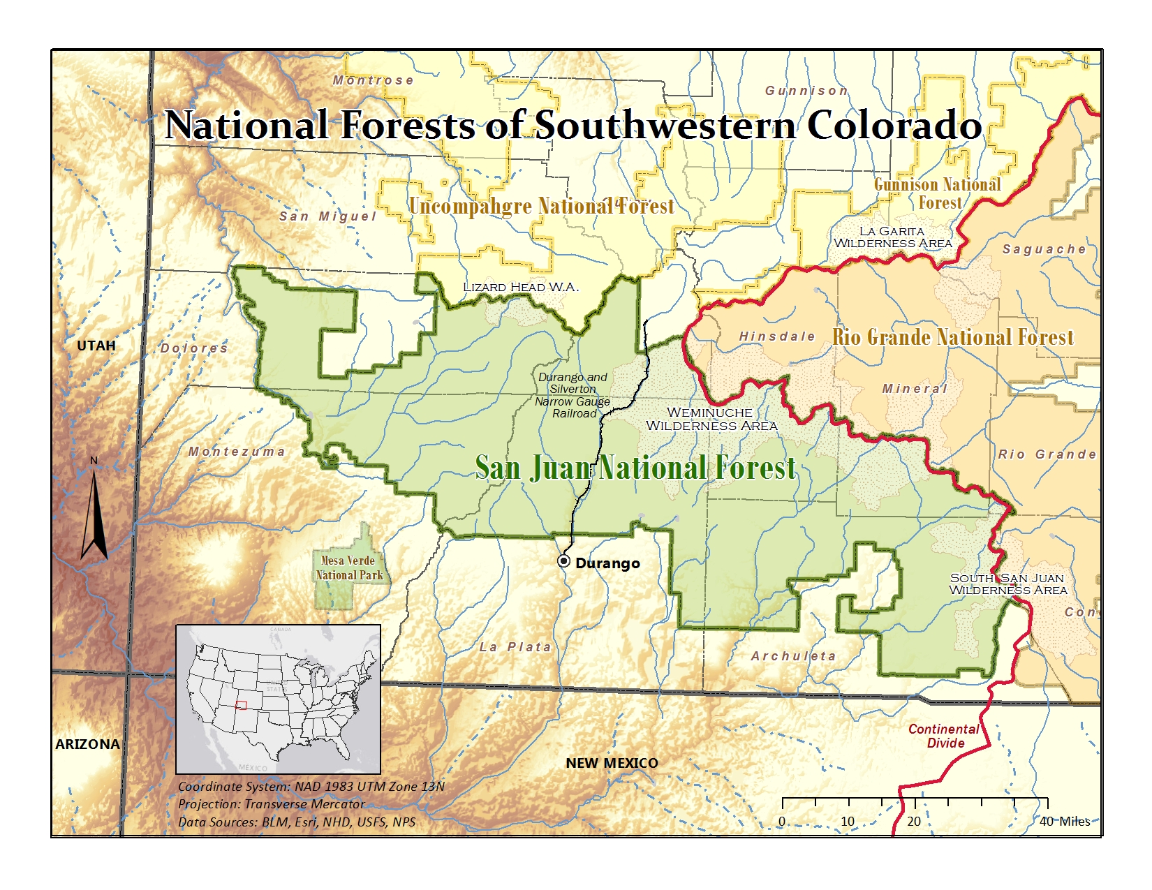
The San Juan National Forest is a U.S. National Forest covering over 1,878,846 acres (2,935.7 sq mi, or 7,603.42 km²) in western Colorado. The forest occupies land in Archuleta, Conejos, Dolores, Hinsdale, La Plata, Mineral, Montezuma, Rio Grande, San Miguel and San Juan Counties. It borders the Uncompahgre National Forest to the north and the Rio Grande National Forest to the east. The forest covers most of the southern portion of the San Juan Mountains west of the Continental Divide. The forest contains two alpine wilderness areas; the Weminuche and South San Juan, as well as the Piedra Area. The Durango and Silverton Narrow Gauge Railroad passes through the National Forest. The name of the forest comes from the San Juan River, which was originally called the Rio San Juan, after Saint John the Baptist (San Juan Bautista in Spanish). History Theodore Roosevelt created the forest by proclamation on June 3, 1905. Forest headquarters are located in Durango, Colo ... [...More Info...] [...Related Items...] OR: [Wikipedia] [Google] [Baidu] |
Mineral County, Colorado
Mineral County is a county located in the U.S. state of Colorado. As of the 2020 census, the population was 865, making it the third-least populous county in Colorado, behind San Juan County and Hinsdale County. The county seat and only incorporated municipality in the county is Creede. The county was named for the many valuable minerals found in the mountains and streams of the area. Geography According to the U.S. Census Bureau, the county has a total area of , of which is land and (0.2%) is water. Adjacent counties * Saguache County - northeast * Rio Grande County - east *Archuleta County - south *Hinsdale County - west Major Highways * U.S. Highway 160 * State Highway 149 National protected areas *Rio Grande National Forest *San Juan National Forest * La Garita Wilderness *Weminuche Wilderness Trails and byways *Colorado Trail *Continental Divide National Scenic Trail * Lake Fork National Recreation Trail * Silver Thread Scenic Byway Demographics At the 20 ... [...More Info...] [...Related Items...] OR: [Wikipedia] [Google] [Baidu] |
Waterfall
A waterfall is a point in a river or stream where water flows over a vertical drop or a series of steep drops. Waterfalls also occur where meltwater drops over the edge of a tabular iceberg or ice shelf. Waterfalls can be formed in several ways, but the most common method of formation is that a river courses over a top layer of resistant bedrock before falling on to softer rock, which erodes faster, leading to an increasingly high fall. Waterfalls have been studied for their impact on species living in and around them. Humans have had a distinct relationship with waterfalls for years, travelling to see them, exploring and naming them. They can present formidable barriers to navigation along rivers. Waterfalls are religious sites in many cultures. Since the 18th century they have received increased attention as tourist destinations, sources of hydropower, andparticularly since the mid-20th centuryas subjects of research. Definition and terminology A waterfall is general ... [...More Info...] [...Related Items...] OR: [Wikipedia] [Google] [Baidu] |
San Juan Mountains
The San Juan Mountains is a high and rugged mountain range in the Rocky Mountains in southwestern Colorado and northwestern New Mexico. The area is highly mineralized (the Colorado Mineral Belt) and figured in the gold and silver mining industry of early Colorado. Major towns, all old mining camps, include Creede, Lake City, Silverton, Ouray, and Telluride. Large scale mining has ended in the region, although independent prospectors still work claims throughout the range. The last large scale mines were the Sunnyside Mine near Silverton, which operated until late in the 20th century and the Idarado Mine on Red Mountain Pass that closed down in the 1970s. Famous old San Juan mines include the Camp Bird and Smuggler Union mines, both located between Telluride and Ouray. The Summitville mine was the scene of a major environmental disaster in the 1990s when the liner of a cyanide-laced tailing pond began leaking heavily. Summitville is in the Summitville caldera, one of ... [...More Info...] [...Related Items...] OR: [Wikipedia] [Google] [Baidu] |
Colorado
Colorado (, other variants) is a state in the Mountain states, Mountain West subregion of the Western United States. It encompasses most of the Southern Rocky Mountains, as well as the northeastern portion of the Colorado Plateau and the western edge of the Great Plains. Colorado is the List of U.S. states and territories by area, eighth most extensive and List of U.S. states and territories by population, 21st most populous U.S. state. The 2020 United States Census, 2020 United States census enumerated the population of Colorado at 5,773,714, an increase of 14.80% since the 2010 United States Census, 2010 United States census. The region has been inhabited by Indigenous peoples of the Americas, Native Americans and their Paleo-Indians, ancestors for at least 13,500 years and possibly much longer. The eastern edge of the Rocky Mountains was a major migration route for early peoples who spread throughout the Americas. "''Colorado''" is the Spanish adjective meaning "ruddy", th ... [...More Info...] [...Related Items...] OR: [Wikipedia] [Google] [Baidu] |
Pagosa Springs, Colorado
The Town of Pagosa Springs (Ute language: Pagwöösa, Navajo language: Tó Sido Háálį́) is a home rule municipality that is the county seat, the most populous community, and the only incorporated municipality in Archuleta County, Colorado, United States. The population was 1,727 at the 2010 census. Approximately 65 percent of the land in Archuleta County is either San Juan National ForestWeminucheanWilderness areas, or Southern Ute Indian reservation land. Pagosa Springs and the surrounding county are both experiencing a substantial influx of second-home owners; a 2006 property assessment indicates that 60% of area private properties are owned by non-residents. Pagosa Springs is located approximately north of the New Mexico border, at above sea level on the Western Slope of the Continental Divide. This combination of high desert plateau and the Rocky Mountains to the north and east creates an unusually mild climate, especially in the summer months. Pagosa sees around ... [...More Info...] [...Related Items...] OR: [Wikipedia] [Google] [Baidu] |
Fall Creek Vertical Pano With Treasure Falls
Autumn, also known as fall in American English and Canadian English, is one of the four temperate seasons on Earth. Outside the tropics, autumn marks the transition from summer to winter, in September (Northern Hemisphere) or March ( Southern Hemisphere). Autumn is the season when the duration of daylight becomes noticeably shorter and the temperature cools considerably. Day length decreases and night length increases as the season progresses until the Winter Solstice in December (Northern Hemisphere) and June (Southern Hemisphere). One of its main features in temperate climates is the striking change in colour for the leaves of deciduous trees as they prepare to shed. Date definitions Some cultures regard the autumnal equinox as "mid-autumn", while others with a longer temperature lag treat the equinox as the start of autumn. In the English-speaking world of high latitude countries, autumn traditionally began with Lammas Day and ended around Hallowe'en, the approxima ... [...More Info...] [...Related Items...] OR: [Wikipedia] [Google] [Baidu] |
Waterfalls Of Colorado
This is a list of waterfalls in the U.S. State of Colorado. __TOC__ Waterfalls of Colorado The following list includes all 81 waterfalls in Colorado that have official names according to the United States Geological Survey. There are also numerous unnamed waterfalls in the state. See also *Hydrology **List of rivers in Colorado This is a list of streams in the U.S. State of Colorado. __TOC__ Alphabetical list The following alphabetical list includes many important streams that flow through the State of Colorado, including all 158 named rivers. Where available, the to ... References External links State of Colorado website*Colorado Division of Natural Resources**Colorado Geological Survey {{DEFAULTSORT:Waterfalls of Colorado, List of Geography of Colorado Lists of landforms of Colorado Tourist attractions in Colorado Colorado, List of waterfalls of ... [...More Info...] [...Related Items...] OR: [Wikipedia] [Google] [Baidu] |
Plunge Waterfalls
A waterfall is a point in a river or stream where water flows over a vertical drop or a series of steep drops. Waterfalls also occur where meltwater drops over the edge of a tabular iceberg or ice shelf. Waterfalls can be formed in several ways, but the most common method of formation is that a river courses over a top layer of resistant bedrock before falling on to softer rock, which erodes faster, leading to an increasingly high fall. Waterfalls have been studied for their impact on species living in and around them. Humans have had a distinct relationship with waterfalls for years, travelling to see them, exploring and naming them. They can present formidable barriers to navigation along rivers. Waterfalls are religious sites in many cultures. Since the 18th century they have received increased attention as tourist destinations, sources of hydropower, andparticularly since the mid-20th centuryas subjects of research. Definition and terminology A waterfall is generally ... [...More Info...] [...Related Items...] OR: [Wikipedia] [Google] [Baidu] |
Landforms Of Mineral County, Colorado
A landform is a natural or anthropogenic land feature on the solid surface of the Earth or other planetary body. Landforms together make up a given terrain, and their arrangement in the landscape is known as topography. Landforms include hills, mountains, canyons, and valleys, as well as shoreline features such as bays, peninsulas, and seas, including submerged features such as mid-ocean ridges, volcanoes, and the great ocean basins. Physical characteristics Landforms are categorized by characteristic physical attributes such as elevation, slope, orientation, stratification, rock exposure and soil type. Gross physical features or landforms include intuitive elements such as berms, mounds, hills, ridges, cliffs, valleys, rivers, peninsulas, volcanoes, and numerous other structural and size-scaled (e.g. ponds vs. lakes, hills vs. mountains) elements including various kinds of inland and oceanic waterbodies and sub-surface features. Mountains, hills, plateaux, and plains are t ... [...More Info...] [...Related Items...] OR: [Wikipedia] [Google] [Baidu] |
Rio Grande National Forest
Rio Grande National Forest is a 1.86 million-acre (7,530 km²) U.S. National Forest located in southwestern Colorado. The forest encompasses the San Luis Valley, which is the world's largest agricultural alpine valley, as well as one of the world's largest high deserts located around mountains. The Rio Grande rises in the forest, and the Continental Divide runs along most of its western border. The forest lies in parts of nine counties. In descending order of land area within the forest they are Saguache, Mineral, Conejos, Rio Grande, Hinsdale, San Juan, Alamosa, Archuleta, and Custer counties. Forest headquarters are currently located in Monte Vista, Colorado, but plan to move to Del Norte. There are local ranger district offices in Del Norte, La Jara, and Saguache. Wilderness areas There are four officially designated wilderness areas lying within Rio Grande National Forest that are part of the National Wilderness Preservation System. All of them extend parti ... [...More Info...] [...Related Items...] OR: [Wikipedia] [Google] [Baidu] |


.jpg)