|
Tolimán (volcano)
Tolimán, also known as Volcán Tolimán, is a stratovolcano in Guatemala, on the southern shores of Lake Atitlán. Part of the Sierra Madre mountain range, the volcano has an elevation of 3,158 m (10,361 ft) and was formed near the southern margin of the Pleistocene Atitlán III caldera. The top of the volcano has a shallow crater and its flanks are covered with the thick remains of ancient lava flows that emerged from vents in the volcano's flanks. Cerro de Oro A parasitic lava dome, known as Cerro de Oro, was formed on the volcano's northern flank, which may have erupted a few thousand years ago. Gallery File:Volcanoes of Lake Atitlán.jpg, The volcanoes of Lake Atitlan; Atitlan (left center), Toliman (center), and San Pedro (far right), as seen from Pachimulin. See also * List of volcanoes in Guatemala References * Mountains of Guatemala Stratovolcanoes of Guatemala Volcano A volcano is commonly defined as a vent or fissure in the crust of a pla ... [...More Info...] [...Related Items...] OR: [Wikipedia] [Google] [Baidu] |
Stratovolcano
A stratovolcano, also known as a composite volcano, is a typically conical volcano built up by many alternating layers (strata) of hardened lava and tephra. Unlike shield volcanoes, stratovolcanoes are characterized by a steep profile with a summit crater and explosive eruptions. Some have collapsed summit craters called calderas. The lava flowing from stratovolcanoes typically cools and solidifies before spreading far, due to high viscosity. The magma forming this lava is often felsic, having high to intermediate levels of silica (as in rhyolite, dacite, or andesite), with lesser amounts of less viscous mafic magma. Extensive felsic lava flows are uncommon, but can travel as far as 8 km (5 mi). The term ''composite volcano'' is used because strata are usually mixed and uneven instead of neat layers. They are among the most common types of volcanoes; more than 700 stratovolcanoes have erupted lava during the Holocene Epoch (the last 11,700 years), and many ol ... [...More Info...] [...Related Items...] OR: [Wikipedia] [Google] [Baidu] |
Lake Atitlán
Lake Atitlán (, ) is a lake in the Guatemalan Highlands of the Sierra Madre mountain range. The lake is located in the Sololá Department of southwestern Guatemala. It is known as the deepest lake in Central America. Name Atitlán means "between the waters". In the Nahuatl language, "atl" is the word for water, and "titlan" means between. The "tl" at the end of the word "atl" is dropped (because it is a grammatical suffix) and the words are combined to form "Atitlán". Geography The lake has a maximum depth of about and an average depth of . Its surface area is . It is approximately with around of water. Atitlán is an endorheic lake, fed by two nearby rivers and not draining into the ocean. It is shaped by deep surrounding escarpments and three volcanoes on its southern flank. The lake basin is volcanic in origin, filling an enormous caldera formed by a supervolcanic eruption 79,500 years ago. The culture of the towns and villages surrounding Lake Atitlán is influenced by ... [...More Info...] [...Related Items...] OR: [Wikipedia] [Google] [Baidu] |
Stratovolcanoes Of Guatemala
A stratovolcano, also known as a composite volcano, is a typically conical volcano built up by many alternating layers (strata) of hardened lava and tephra. Unlike shield volcanoes, stratovolcanoes are characterized by a steep profile with a summit crater and explosive eruptions. Some have collapsed summit craters called calderas. The lava flowing from stratovolcanoes typically cools and solidifies before spreading far, due to high viscosity. The magma forming this lava is often felsic, having high to intermediate levels of silica (as in rhyolite, dacite, or andesite), with lesser amounts of less viscous mafic magma. Extensive felsic lava flows are uncommon, but can travel as far as 8 km (5 mi). The term ''composite volcano'' is used because strata are usually mixed and uneven instead of neat layers. They are among the most common types of volcanoes; more than 700 stratovolcanoes have erupted lava during the Holocene Epoch (the last 11,700 years), and many older, now ... [...More Info...] [...Related Items...] OR: [Wikipedia] [Google] [Baidu] |
Mountains Of Guatemala
A mountain is an elevated portion of the Earth's crust, generally with steep sides that show significant exposed bedrock. Although definitions vary, a mountain may differ from a plateau in having a limited summit area, and is usually higher than a hill, typically rising at least above the surrounding land. A few mountains are isolated summits, but most occur in mountain ranges. Mountains are formed through tectonic forces, erosion, or volcanism, which act on time scales of up to tens of millions of years. Once mountain building ceases, mountains are slowly leveled through the action of weathering, through slumping and other forms of mass wasting, as well as through erosion by rivers and glaciers. High elevations on mountains produce colder climates than at sea level at similar latitude. These colder climates strongly affect the ecosystems of mountains: different elevations have different plants and animals. Because of the less hospitable terrain and climate, mountains te ... [...More Info...] [...Related Items...] OR: [Wikipedia] [Google] [Baidu] |
List Of Volcanoes In Guatemala ...
This is a list of active, dormant, and extinct volcanoes in Guatemala. Volcanoes See also * Central America Volcanic Arc * List of volcanoes in El Salvador * List of volcanoes in Honduras * List of volcanoes in Mexico Footnotes References {{Central American volcanoes Guatemala *List Volcanoes A volcano is commonly defined as a vent or fissure in the crust of a planetary-mass object, such as Earth, that allows hot lava, volcanic ash, and gases to escape from a magma chamber below the surface. On Earth, volcanoes are most often fo ... [...More Info...] [...Related Items...] OR: [Wikipedia] [Google] [Baidu] |
Lava Dome
In volcanology, a lava dome is a circular, mound-shaped protrusion resulting from the slow extrusion of viscous lava from a volcano. Dome-building eruptions are common, particularly in convergent plate boundary settings. Around 6% of eruptions on Earth form lava domes. The geochemistry of lava domes can vary from basalt (e.g. Semeru, 1946) to rhyolite (e.g. Chaiten, 2010) although the majority are of intermediate composition (such as Santiaguito, dacite-andesite, present day). The characteristic dome shape is attributed to high viscosity that prevents the lava from flowing very far. This high viscosity can be obtained in two ways: by high levels of silica in the magma, or by degassing of fluid magma. Since viscous basaltic and andesitic domes weather fast and easily break apart by further input of fluid lava, most of the preserved domes have high silica content and consist of rhyolite or dacite. Existence of lava domes has been suggested for some domed structures on the ... [...More Info...] [...Related Items...] OR: [Wikipedia] [Google] [Baidu] |
Pleistocene
The Pleistocene ( ; referred to colloquially as the ''ice age, Ice Age'') is the geological epoch (geology), epoch that lasted from to 11,700 years ago, spanning the Earth's most recent period of repeated glaciations. Before a change was finally confirmed in 2009 by the International Union of Geological Sciences, the cutoff of the Pleistocene and the preceding Pliocene was regarded as being 1.806 million years Before Present (BP). Publications from earlier years may use either definition of the period. The end of the Pleistocene corresponds with the end of the last glacial period and also with the end of the Paleolithic age used in archaeology. The name is a combination of Ancient Greek () 'most' and (; Latinized as ) 'new'. The aridification and cooling trends of the preceding Neogene were continued in the Pleistocene. The climate was strongly variable depending on the glacial cycle, oscillating between cold Glacial period, glacial periods and warmer Interglacial, int ... [...More Info...] [...Related Items...] OR: [Wikipedia] [Google] [Baidu] |
Foot (length)
The foot (standard symbol: ft) is a unit of length in the British imperial and United States customary systems of measurement. The prime symbol, , is commonly used to represent the foot. In both customary and imperial units, one foot comprises 12 inches, and one yard comprises three feet. Since an international agreement in 1959, the foot is defined as equal to exactly 0.3048 meters. Historically, the "foot" was a part of many local systems of units, including the Greek, Roman, Chinese, French, and English systems. It varied in length from country to country, from city to city, and sometimes from trade to trade. Its length was usually between 250 mm and 335 mm and was generally, but not always, subdivided into 12 inches or 16 digits. The United States is the only industrialized country that uses the (international) foot in preference to the meter in its commercial, engineering, and standards activities. The foot is legally recognized in th ... [...More Info...] [...Related Items...] OR: [Wikipedia] [Google] [Baidu] |
Metre
The metre (or meter in US spelling; symbol: m) is the base unit of length in the International System of Units (SI). Since 2019, the metre has been defined as the length of the path travelled by light in vacuum during a time interval of of a second, where the second is defined by a hyperfine transition frequency of caesium. The metre was originally defined in 1791 by the French National Assembly as one ten-millionth of the distance from the equator to the North Pole along a great circle, so the Earth's polar circumference is approximately . In 1799, the metre was redefined in terms of a prototype metre bar. The bar used was changed in 1889, and in 1960 the metre was redefined in terms of a certain number of wavelengths of a certain emission line of krypton-86. The current definition was adopted in 1983 and modified slightly in 2002 to clarify that the metre is a measure of proper length. From 1983 until 2019, the metre was formally defined as the length of the pat ... [...More Info...] [...Related Items...] OR: [Wikipedia] [Google] [Baidu] |
Guatemala
Guatemala, officially the Republic of Guatemala, is a country in Central America. It is bordered to the north and west by Mexico, to the northeast by Belize, to the east by Honduras, and to the southeast by El Salvador. It is hydrologically bordered to the south by the Pacific Ocean and to the northeast by the Gulf of Honduras. The territory of modern Guatemala hosted the core of the Maya civilization, which extended across Mesoamerica; in the 16th century, most of this was Spanish conquest of Guatemala, conquered by the Spanish and claimed as part of the viceroyalty of New Spain. Guatemala attained independence from Spain and Mexico in 1821. From 1823 to 1841, it was part of the Federal Republic of Central America. For the latter half of the 19th century, Guatemala suffered instability and civil strife. From the early 20th century, it was ruled by a series of dictators backed by the United States. In 1944, authoritarian leader Jorge Ubico was overthrown by a pro-democratic m ... [...More Info...] [...Related Items...] OR: [Wikipedia] [Google] [Baidu] |
Sololá Department
__NOTOC__ Sololá is a city in Guatemala. It is the capital of the department of Sololá and the administrative seat of Sololá municipality. It is located close to Lake Atitlan. The name is a Hispanicized form of its pre-Columbian name, one spelling variant of which is Tz'olojya. The urban center has about 14,000 people, but the municipality also includes four village communities — Los Encuentros, El Tablón, San Jorge la Laguna, and Argueta — as well as 59 smaller rural communities. Sololá is situated at 2,114 m altitude on a mountainside overlooking Lake Atitlán, some 600 meters below. It is a highland market center and is the headquarters for the Catholic Bishopric encompassing the Sololá and Chimaltenango Departments. Almost all residents of Sololá are Kaqchikel Maya, except in Argueta, where most are K'iche' Maya. A large percentage of both men and women continue to wear traditional Mayan clothing. Sololá is home to many international organizations includi ... [...More Info...] [...Related Items...] OR: [Wikipedia] [Google] [Baidu] |
Central America Volcanic Arc
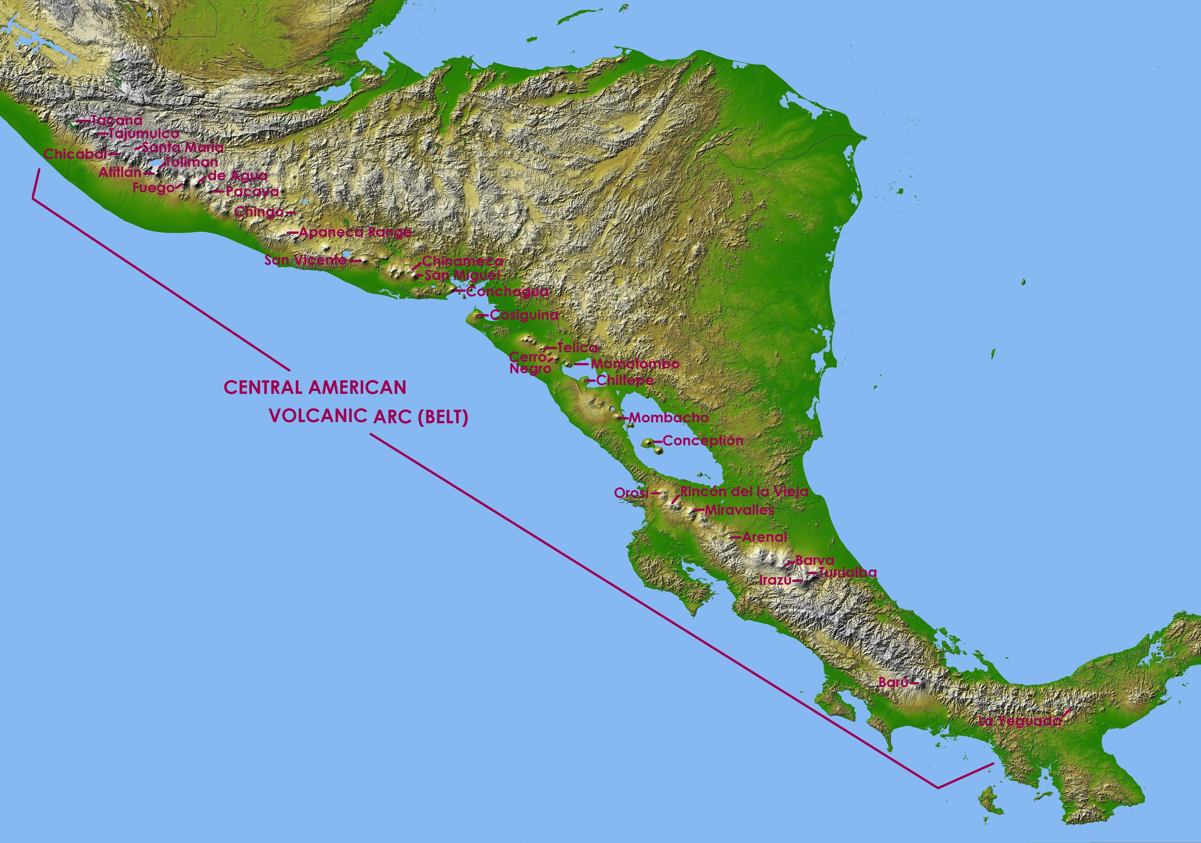
The Central American Volcanic Arc (often abbreviated to CAVA) is a chain of volcanoes which extends parallel to the Pacific coastline of the Central American Isthmus, from Mexico to Panama. This volcanic arc, which has a length of 1,100 kilometers (680 mi)Rose, W., Conway, F., Pullinger, C., Deino, A. and McIntosh, W., 1999. An improved age framework for late Quaternary silicic eruptions in northern Central America. ''Bulletin of Volcanology'', 61(1-2), pp.106-120. is formed by an active subduction zone, with the Cocos plate subducting underneath the Caribbean plate,Álvarez-Gómez, J., Meijer, P., Martínez-Díaz, J. and Capote, R., 2008. Constraints from finite element modeling on the active tectonics of northern Central America and the Middle America Trench. ''Tectonics'', 27(1) the North American plate and the Panama plate. Volcanic activity is recorded in the Central American region since the Permian. Numerous volcanoes are spread throughout various Central American ... [...More Info...] [...Related Items...] OR: [Wikipedia] [Google] [Baidu] |


