|
Tasmanian Passage
The Tasmanian Passage, also Tasmanian Gateway or Tasmanian Seaway, is the name of ocean waters between Australia (continent), Australia and Antarctica. It was formed from the separation of the two continental plates of Australia and Antarctica about 30 to 40 million years ago, and opened to water circulation around 33.5 Ma. The Tasman Passage connects the Indian Ocean with the Pacific Ocean south of Australia. The term comes from geology. The distance between the two continents is currently about . Through the opening of the Drake Passage and the Tasmanian Passage, the Antarctic circumpolar current was able to form at the onset of the Oligocene, replacing the circumpacial equatorial flow conditions of the Cretaceous. The emergence of the circumpolar current led to a thermal isolation of the Antarctic, since the exchange with equatorial warm waters was greatly reduced. As a result, the ice sheets of Antarctica formed and the Earth entered the Late Cenozoic Ice Age (the curren ... [...More Info...] [...Related Items...] OR: [Wikipedia] [Google] [Baidu] |
Australia (continent)
The continent of Australia, sometimes known in technical contexts as Sahul (), Australia-New Guinea, Australinea, or Meganesia to distinguish it from the Australia, country of Australia, is located within the Southern Hemisphere, Southern and Eastern Hemisphere, Eastern hemispheres, near the Maritime Southeast Asia. The continent includes mainland Australia, Tasmania, the island of New Guinea (Papua New Guinea and Western New Guinea), the Aru Islands Regency, Aru Islands, the Ashmore and Cartier Islands, most of the Coral Sea Islands, and some other list of islands of Australia, nearby islands. Situated in the geographical region of Oceania, more specifically in the subregion of Australasia, Australia is the Continent#Area and population, smallest of the seven traditional continents. The continent includes a continental shelf overlain by shallow seas which divide it into several landmasses—the Arafura Sea and Torres Strait between mainland Australia and New Guinea, and Bass ... [...More Info...] [...Related Items...] OR: [Wikipedia] [Google] [Baidu] |
Antarctica
Antarctica () is Earth's southernmost and least-populated continent. Situated almost entirely south of the Antarctic Circle and surrounded by the Southern Ocean (also known as the Antarctic Ocean), it contains the geographic South Pole. Antarctica is the fifth-largest continent, being about 40% larger than Europe, and has an area of . Most of Antarctica is covered by the Antarctic ice sheet, with an average thickness of . Antarctica is, on average, the coldest, driest, and windiest of the continents, and it has the highest average elevation. It is mainly a polar desert, with annual Climate of Antarctica#Precipitation, precipitation of over along the coast and far less inland. About 70% of the world's freshwater reserves are frozen in Antarctica, which, if melted, would raise global sea levels by almost . Antarctica holds the record for the Lowest temperature recorded on Earth, lowest measured temperature on Earth, . The coastal regions can reach temperatures over in the ... [...More Info...] [...Related Items...] OR: [Wikipedia] [Google] [Baidu] |
Indian Ocean
The Indian Ocean is the third-largest of the world's five oceanic divisions, covering or approximately 20% of the water area of Earth#Surface, Earth's surface. It is bounded by Asia to the north, Africa to the west and Australia (continent), Australia to the east. To the south it is bounded by the Southern Ocean or Antarctica, depending on the definition in use. The Indian Ocean has large marginal or regional seas, including the Andaman Sea, the Arabian Sea, the Bay of Bengal, and the Laccadive Sea. Geologically, the Indian Ocean is the youngest of the oceans, and it has distinct features such as narrow continental shelf, continental shelves. Its average depth is 3,741 m. It is the warmest ocean, with a significant impact on global climate due to its interaction with the atmosphere. Its waters are affected by the Indian Ocean Walker circulation, resulting in unique oceanic currents and upwelling patterns. The Indian Ocean is ecologically diverse, with important ecosystems such ... [...More Info...] [...Related Items...] OR: [Wikipedia] [Google] [Baidu] |
Pacific Ocean
The Pacific Ocean is the largest and deepest of Earth's five Borders of the oceans, oceanic divisions. It extends from the Arctic Ocean in the north to the Southern Ocean, or, depending on the definition, to Antarctica in the south, and is bounded by the continents of Asia and Australia in the west and the Americas in the east. At in area (as defined with a southern Antarctic border), the Pacific Ocean is the largest division of the World Ocean and the hydrosphere and covers approximately 46% of Earth's water surface and about 32% of the planet's total surface area, larger than its entire land area ().Pacific Ocean . ''Encyclopædia Britannica, Britannica Concise.'' 2008: Encyclopædia Britannica, Inc. The centers of both the Land and water hemispheres, water hemisphere and the Western Hemisphere, as well as the Pole of inaccessi ... [...More Info...] [...Related Items...] OR: [Wikipedia] [Google] [Baidu] |
Drake Passage
The Drake Passage is the body of water between South America's Cape Horn, Chile, Argentina, and the South Shetland Islands of Antarctica. It connects the southwestern part of the Atlantic Ocean (Scotia Sea) with the southeastern part of the Pacific Ocean and extends into the Southern Ocean. The passage is named after the 16th-century English explorer and privateer Sir Francis Drake. The Drake Passage is considered one of the most treacherous voyages for ships to make. The Antarctic Circumpolar Current, which runs through it, meets no resistance from any landmass, and waves top , giving it a reputation for being "the most powerful convergence of seas". As the Drake Passage is the narrowest passage (choke point) around Antarctica, its existence and shape strongly influence the circulation of water around Antarctica and the global oceanic circulation, as well as the global climate. The bathymetry of the Drake Passage plays an important role in the global mixing of oceanic water ... [...More Info...] [...Related Items...] OR: [Wikipedia] [Google] [Baidu] |
Oligocene
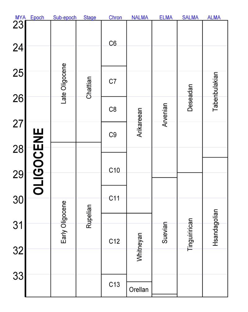
The Oligocene ( ) is a geologic epoch (geology), epoch of the Paleogene Geologic time scale, Period that extends from about 33.9 million to 23 million years before the present ( to ). As with other older geologic periods, the rock beds that define the epoch are well identified but the exact dates of the start and end of the epoch are slightly uncertain. The name Oligocene was coined in 1854 by the German paleontologist Heinrich Ernst Beyrich from his studies of marine beds in Belgium and Germany. The name comes from Ancient Greek (''olígos'') 'few' and (''kainós'') 'new', and refers to the sparsity of Neontology, extant forms of Mollusca, molluscs. The Oligocene is preceded by the Eocene Epoch and is followed by the Miocene Epoch. The Oligocene is the third and final epoch of the Paleogene Period. The Oligocene is often considered an important time of transition, a link between the archaic world of the tropical Eocene and the more modern ecosystems of the Miocene. Major chang ... [...More Info...] [...Related Items...] OR: [Wikipedia] [Google] [Baidu] |
Cretaceous
The Cretaceous ( ) is a geological period that lasted from about 143.1 to 66 mya (unit), million years ago (Mya). It is the third and final period of the Mesozoic Era (geology), Era, as well as the longest. At around 77.1 million years, it is the ninth and longest geological period of the entire Phanerozoic. The name is derived from the Latin , 'chalk', which is abundant in the latter half of the period. It is usually abbreviated K, for its German translation . The Cretaceous was a period with a relatively warm climate, resulting in high Sea level#Local and eustatic, eustatic sea levels that created numerous shallow Inland sea (geology), inland seas. These oceans and seas were populated with now-extinct marine reptiles, ammonites, and rudists, while dinosaurs continued to dominate on land. The world was largely ice-free, although there is some evidence of brief periods of glaciation during the cooler first half, and forests extended to the poles. Many of the dominant taxonomic gr ... [...More Info...] [...Related Items...] OR: [Wikipedia] [Google] [Baidu] |
Antarctic
The Antarctic (, ; commonly ) is the polar regions of Earth, polar region of Earth that surrounds the South Pole, lying within the Antarctic Circle. It is antipodes, diametrically opposite of the Arctic region around the North Pole. The Antarctic comprises the continent of Antarctica, the Kerguelen Plateau, and other list of Antarctic and Subantarctic islands, island territories located on the Antarctic Plate or south of the Antarctic Convergence. The Antarctic region includes the ice shelf, ice shelves, waters, and all the island territories in the Southern Ocean situated south of the Antarctic Convergence, a zone approximately wide and varying in latitude seasonally. The region covers some 20 percent of the Southern Hemisphere, of which 5.5 percent (14 million km2) is the surface area of the Antarctica continent itself. All of the land and ice shelf, ice shelves south of 60th parallel south, 60°S latitude are administered under the Antarctic Treaty System. Biogeograph ... [...More Info...] [...Related Items...] OR: [Wikipedia] [Google] [Baidu] |
Earth
Earth is the third planet from the Sun and the only astronomical object known to Planetary habitability, harbor life. This is enabled by Earth being an ocean world, the only one in the Solar System sustaining liquid surface water. Almost all of Earth's water is contained in its global ocean, covering Water distribution on Earth, 70.8% of Earth's crust. The remaining 29.2% of Earth's crust is land, most of which is located in the form of continental landmasses within Earth's land hemisphere. Most of Earth's land is at least somewhat humid and covered by vegetation, while large Ice sheet, sheets of ice at Polar regions of Earth, Earth's polar polar desert, deserts retain more water than Earth's groundwater, lakes, rivers, and Water vapor#In Earth's atmosphere, atmospheric water combined. Earth's crust consists of slowly moving tectonic plates, which interact to produce mountain ranges, volcanoes, and earthquakes. Earth's outer core, Earth has a liquid outer core that generates a ... [...More Info...] [...Related Items...] OR: [Wikipedia] [Google] [Baidu] |
Late Cenozoic Ice Age
The Late Cenozoic Ice Age,National Academy of Sciences - The National Academies Press - Continental Glaciation through Geologic Times https://www.nap.edu/read/11798/chapter/8#80 or Antarctic Glaciation, began 34 million years ago at the Eocene–Oligocene extinction event, Eocene-Oligocene Boundary and is ongoing. It is Earth's current ice age or Greenhouse and icehouse Earth, icehouse period. Its beginning is marked by the formation of the Antarctic ice sheets. Six million years after the start of the Late Cenozoic Ice Age, the East Antarctic Ice Sheet had formed, and 14 million years ago it had reached its current extent. In the last three million years, glaciations have spread to the northern hemisphere. It commenced with Greenland becoming increasingly covered by an ice sheet in late Pliocene (2.9-2.58 Ma ago) During the Pleistocene, Pleistocene Epoch (starting 2.58 Ma ago), the Quaternary glaciation developed with decreasing mean temperatures and increasing amplitudes betw ... [...More Info...] [...Related Items...] OR: [Wikipedia] [Google] [Baidu] |
Antarctic Region
The Antarctic (, ; commonly ) is the polar region of Earth that surrounds the South Pole, lying within the Antarctic Circle. It is diametrically opposite of the Arctic region around the North Pole. The Antarctic comprises the continent of Antarctica, the Kerguelen Plateau, and other island territories located on the Antarctic Plate or south of the Antarctic Convergence. The Antarctic region includes the ice shelves, waters, and all the island territories in the Southern Ocean situated south of the Antarctic Convergence, a zone approximately wide and varying in latitude seasonally. The region covers some 20 percent of the Southern Hemisphere, of which 5.5 percent (14 million km2) is the surface area of the Antarctica continent itself. All of the land and ice shelves south of 60°S latitude are administered under the Antarctic Treaty System. Biogeographically, the Antarctic realm is one of eight biogeographic realms on Earth's land surface. Climate change in A ... [...More Info...] [...Related Items...] OR: [Wikipedia] [Google] [Baidu] |


