|
Takahama, Aichi
is a Cities of Japan, city located in central Aichi Prefecture, Japan. , the city had an estimated population of 48,736 in 20,500 households, and a population density of 3,717 persons per km2. The total area of the city is . Geography Takahama is situated in south-central Aichi Prefecture, on Kinuura Bay at the head of Atsumi Peninsula. Climate The city has a climate characterized by hot and humid summers, and relatively mild winters (Köppen climate classification ''Cfa''). The average annual temperature in Takahama is 15.7 °C. The average annual rainfall is 1592 mm with September as the wettest month. The temperatures are highest on average in August, at around 27.8 °C, and lowest in January, at around 4.4 °C. Demographics Per Japanese census data, the population of Takahama has been relatively steady over the past 50 years. Neighboring municipalities ;Aichi Prefecture *Anjō, Aichi, Anjō *Handa, Aichi, Handa *Hekinan, Aichi, Hekinan *Higashiura, Ai ... [...More Info...] [...Related Items...] OR: [Wikipedia] [Google] [Baidu] |
Cities Of Japan
A is a local Public administration, administrative unit in Japan. Cities are ranked on the same level as and , with the difference that they are not a component of . Like other contemporary administrative units, they are defined by the Local Autonomy Law of 1947. City status Article 8 of the Local Autonomy Law sets the following conditions for a municipality to be designated as a city: *Population must generally be 50,000 or greater (原則として人口5万人以上) *At least 60% of households must be established in a central urban area (中心市街地の戸数が全戸数の6割以上) *At least 60% of households must be employed in commerce, industry or other urban occupations (商工業等の都市的業態に従事する世帯人口が全人口の6割以上) *Any other conditions set by prefectural ordinance must be satisfied (他に当該都道府県の条例で定める要件を満たしていること) The designation is approved by the prefectural governor and t ... [...More Info...] [...Related Items...] OR: [Wikipedia] [Google] [Baidu] |
Gifu Prefecture
is a Prefectures of Japan, prefecture of Japan located in the Chūbu region of Honshu. Gifu Prefecture has a population of 1,910,511 () and has a geographic area of . Gifu Prefecture borders Toyama Prefecture to the north; Ishikawa Prefecture to the northwest, Fukui Prefecture and Shiga Prefecture to the west, Mie Prefecture to the southwest, Aichi Prefecture to the south, and Nagano Prefecture to the east. Gifu is the capital and largest city of Gifu Prefecture, with other major cities including Ōgaki, Kakamigahara, and Tajimi. Gifu Prefecture is located in the center of Japan, one of only eight landlocked prefectures, and features the country's center of population. Gifu Prefecture has served as the historic Intersection (road), crossroads of Japan with routes connecting the east to the west, including the Nakasendō, one of the Edo Five Routes, Five Routes of the Edo period. Gifu Prefecture was a long-term residence of Oda Nobunaga and Saitō Dōsan, two influential figur ... [...More Info...] [...Related Items...] OR: [Wikipedia] [Google] [Baidu] |
Mizunami, Gifu
city located in Gifu Prefecture">Gifu, Japan. , the city had an estimated population of 37,705, and a population density of 220 persons per km2. The total area of the city was . Mizunami's biggest claim to fame came in 1995, when the largest ceramic plate in the world, as recognised by the Guinness Book of Records, was created by the Inatsu Town Planning Association in the city. It measures 2.8 metres in diameter. Geography Mizunami is located in south-eastern Gifu Prefecture. The Kiso River and the Toki River flow through the city. Climate The city has a climate characterized by characterized by hot and humid summers, and mild winters (Köppen climate classification ''Cfa''). The average annual temperature in Mizunami is 14.8 °C. The average annual rainfall is 1928 mm with September as the wettest month. The temperatures are highest on average in August, at around 27.2 °C, and lowest in January, at around 3.0 °C. Neighbouring municipalities *Aichi Pref ... [...More Info...] [...Related Items...] OR: [Wikipedia] [Google] [Baidu] |
Diet Of Japan
, transcription_name = ''Kokkai'' , legislature = 215th Session of the National Diet , coa_pic = Flag of Japan.svg , house_type = Bicameral , houses = , foundation=29 November 1890(), leader1_type = President of the House of Councillors , leader1 = Masakazu Sekiguchi , party1 = LDP , election1 = 11 November 2024 , leader2_type = Speaker of the House of Representatives , leader2 = Fukushiro Nukaga , party2 = LDP , election2 = 11 November 2024 , leader3_type = Prime Minister , leader3 = Shigeru Ishiba , party3 = LDP , election3 = 1 October 2024 , members = , house1 = House of Councillors , structure1 = Japan House of Councillors Political Groups - November 2024.svg , political_groups1 = Government (140) * LDP (113) * Kōmeitō (27) Opposition (91) * CDP- SDP (41) * ... [...More Info...] [...Related Items...] OR: [Wikipedia] [Google] [Baidu] |
House Of Representatives Of Japan
The is the lower house of the National Diet of Japan. The House of Councillors is the upper house. The composition of the House is established by and of the Constitution of Japan. The House of Representatives has 465 members, elected for a four-year term. Of these, 176 members are elected from 11 multi-member constituencies by a Party-list proportional representation, party-list system of proportional representation, and 289 are elected from single-member constituencies. The overall voting system used to elect the House of Representatives is a Parallel voting, parallel system, a form of semi-proportional representation. Under a parallel system, the allocation of list seats does not take into account the outcome in the single seat constituencies. Therefore, the overall allocation of seats in the House of Representatives is not proportional, to the advantage of larger parties. In contrast, in bodies such as the German ''Bundestag'' or the New Zealand Parliament the election of s ... [...More Info...] [...Related Items...] OR: [Wikipedia] [Google] [Baidu] |
Unicameral
Unicameralism (from ''uni''- "one" + Latin ''camera'' "chamber") is a type of legislature consisting of one house or assembly that legislates and votes as one. Unicameralism has become an increasingly common type of legislature, making up nearly 60% of all national legislatures and an even greater share of subnational legislatures. Sometimes, as in New Zealand and Denmark, unicameralism comes about through the abolition of one of two bicameral chambers, or, as in Sweden, through the merger of the two chambers into a single one, while in others a second chamber has never existed from the beginning. Rationale for unicameralism and criticism The principal advantage of a unicameral system is more efficient lawmaking, as the legislative process is simpler and there is no possibility of gridlock (politics), deadlock between two chambers. Proponents of unicameralism have also argued that it reduces costs, even if the number of legislators stays the same, since there are fewer instituti ... [...More Info...] [...Related Items...] OR: [Wikipedia] [Google] [Baidu] |
Takahama City Hall In Nov
Takahama can refer to: Places * Takahama, Aichi, a city in Aichi Prefecture, Japan * Takahama, Fukui, a town in Fukui Prefecture, Japan People * Aiko Takahama, women's professional shogi player * Kyoshi Takahama (1874 – 1959), a Japanese writer * Takahama Tatsurō (b. 1976), former fighting name Japanese sumo wrestler now known as Hamanishiki Tatsurō Hamanishiki Tatsurō (born November 23, 1976, as Tatsurō Takahama) is a former sumo wrestler from Kumamoto, Japan. A former amateur champion, he made his professional debut in 1999. His highest rank was '' maegashira'' 11, which he reached in 20 ... {{disambiguation, geo ... [...More Info...] [...Related Items...] OR: [Wikipedia] [Google] [Baidu] |
Owariasahi
is a city located in Aichi Prefecture, Japan. , the city had an estimated population of 81,954 in 35,583 households, and a population density of 3,897 persons per km². The total area of the city is . Geography Owariasahi is located in west-central Aichi Prefecture, north of the Nagoya metropolis. The Aichi Prefectural Forest Park covers approximately 15% of its area. Climate The city has a climate characterized by hot and humid summers, and relatively mild winters (Köppen climate classification ''Cfa''). The average annual temperature in Owariasahi is 15.5 °C. The average annual rainfall is 1665 mm with September as the wettest month. The temperatures are highest on average in August, at around 28.0 °C, and lowest in January, at around 4.0 °C. Demographics Per Japanese census data, the population of Owariasahi has been increasing rapidly over the past 50 years. Surrounding municipalities ;Aichi Prefecture * Nagakute *Nagoya ( Moriyama-ku) * Seto Hi ... [...More Info...] [...Related Items...] OR: [Wikipedia] [Google] [Baidu] |
Hekikai District, Aichi
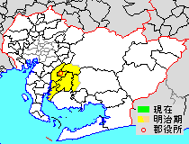
was a district located in central Aichi Prefecture, Japan. As a result of various consolidations and mergers of municipalities, the district was incorporated into the five cities of Kariya, Anjō, Takahama, Chiryū and Hekinan in 2005. History Hekikai-gun is one of the ancient counties of western Mikawa Province and is mentioned in Nara period records, under the alternative pronunciation of the ''kanji'' in its name (Aomi), of which the only remain is Aomi-cho, a section of Takahama. In the Edo period, under the Tokugawa shogunate, most of the district was either part of Kariya Domain, a feudal domain, or ''tenryō'' territory administered directly by the shogunate, and was of the richest agricultural areas of Mikawa. After the Meiji Restoration, the area was merged into Aichi Prefecture. District Timeline * October 1, 1889 - In the cadastral reforms of the early Meiji period, Hekikai District was formed, and initially consisted of three towns (Chiryū, Kariya and ... [...More Info...] [...Related Items...] OR: [Wikipedia] [Google] [Baidu] |
Kariya, Aichi
is a Cities of Japan, city in central Aichi Prefecture, Japan. , the city had an estimated population of 153,162 in 66,751 households, and a population density of 3,040 persons per km2. The total area of the city is . Geography Kariya is situated in central Aichi Prefecture, on the Mikawa Province, Mikawa side of the border between former Owari Province and Mikawa Province. The area is flat and well-watered, with an average elevation of less than 10 meters above sea level. Climate The city has a climate characterized by hot and humid summers, and relatively mild winters (Köppen climate classification ''Cfa''). The average annual temperature in Aisai is 15.7 °C. The average annual rainfall is 1578 mm with September as the wettest month. The temperatures are highest on average in August, at around 27.9 °C, and lowest in January, at around 4.4 °C. Demographics Per Japanese census data, the population of Kariya has grown steadily over the past 70 years. N ... [...More Info...] [...Related Items...] OR: [Wikipedia] [Google] [Baidu] |


