|
Strausberger Platz
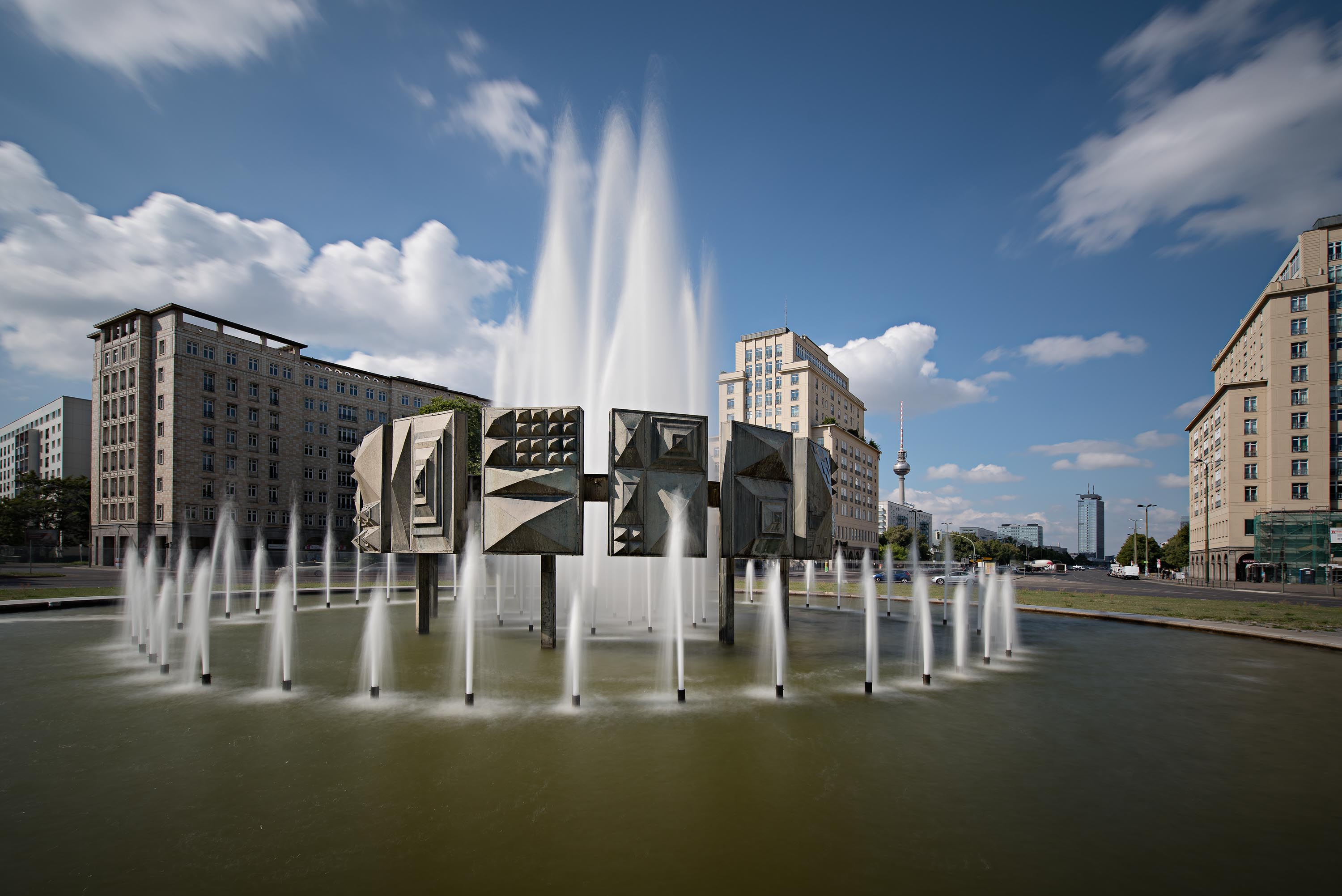
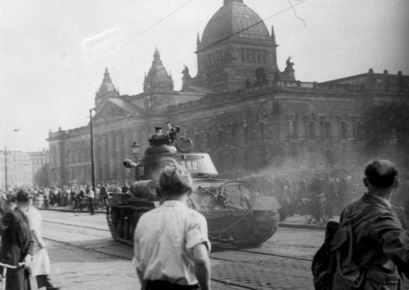
The Strausberger Platz is a large urban square in the Berlin district of Friedrichshain-Kreuzberg and marks the border to the district of Mitte. It is connected via Karl-Marx-Allee with Alexanderplatz and via ''Lichtenberger Straße'' with the ''Platz der Vereinten Nationen''. These two streets intersect in an oval roundabout at Strausberger Platz. History The square was the starting point for the East German uprising of 1953 The East German uprising of 1953 (german: Volksaufstand vom 17. Juni 1953 ) was an uprising that occurred in East Germany from 16 to 17 June 1953. It began with a strike action by construction workers in East Berlin on 16 June against w ..., when DDR wanted to increase the 'working norm' making workers work longer for the same pay. Gallery Strausberger Platz Berlin April 2006 109.jpg, La Strausberger Platz (Karl-Marx-Allee, Berlin) (6074767056).jpg, 20181003 Berlin-35.tif, Strausberger Platz.JPG, References External links * {{coord, ... [...More Info...] [...Related Items...] OR: [Wikipedia] [Google] [Baidu] |
Berlin
Berlin ( , ) is the capital and largest city of Germany by both area and population. Its 3.7 million inhabitants make it the European Union's most populous city, according to population within city limits. One of Germany's sixteen constituent states, Berlin is surrounded by the State of Brandenburg and contiguous with Potsdam, Brandenburg's capital. Berlin's urban area, which has a population of around 4.5 million, is the second most populous urban area in Germany after the Ruhr. The Berlin-Brandenburg capital region has around 6.2 million inhabitants and is Germany's third-largest metropolitan region after the Rhine-Ruhr and Rhine-Main regions. Berlin straddles the banks of the Spree, which flows into the Havel (a tributary of the Elbe) in the western borough of Spandau. Among the city's main topographical features are the many lakes in the western and southeastern boroughs formed by the Spree, Havel and Dahme, the largest of which is Lake Müggelsee. Due to its l ... [...More Info...] [...Related Items...] OR: [Wikipedia] [Google] [Baidu] |
Friedrichshain-Kreuzberg
Friedrichshain-Kreuzberg () is the second borough of Berlin, formed in 2001 by merging the former East Berlin borough of Friedrichshain and the former West Berlin borough of Kreuzberg. The historic Oberbaum Bridge, formerly a Berlin border crossing for pedestrians, links both districts across the river Spree as the new borough's landmark (as featured in the coat of arms). The counterculture tradition especially of Kreuzberg has led to the borough being a stronghold for the Green Party. While Kreuzberg is characterised by a high number of immigrants, the share of non-German citizens in Friedrichshain is much lower and the average age is higher. The merger between the distinct quarters is celebrated by an annual anarchic "vegetable fight" on the Oberbaumbrücke. Both parts have to deal with the consequences of gentrification. Subdivision Friedrichshain-Kreuzberg is divided into 2 localities, Friedrichshain and Kreuzberg. Politics District council The governing body of Friedric ... [...More Info...] [...Related Items...] OR: [Wikipedia] [Google] [Baidu] |
Mitte
Mitte () is the first and most central borough of Berlin. The borough consists of six sub-entities: Mitte proper, Gesundbrunnen, Hansaviertel, Moabit, Tiergarten and Wedding. It is one of the two boroughs (the other being Friedrichshain-Kreuzberg) which were formerly divided between East Berlin and West Berlin. Mitte encompasses Berlin's historic core and includes some of the most important tourist sites of Berlin like the Reichstag and Berlin Hauptbahnhof, Checkpoint Charlie, Museum Island, the TV tower, Brandenburg Gate, Unter den Linden, Potsdamer Platz, Alexanderplatz, the latter six of which were in former East Berlin. Geography Mitte (German for "middle", "centre") is located in the central part of Berlin along the Spree River. It borders on Charlottenburg-Wilmersdorf in the west, Reinickendorf in the north, Pankow in the east, Friedrichshain-Kreuzberg in the southeast, and Tempelhof-Schöneberg in the southwest. In the middle of the Spree lies Museum Island (''Museum ... [...More Info...] [...Related Items...] OR: [Wikipedia] [Google] [Baidu] |
Karl-Marx-Allee
Karl-Marx-Allee ( en, Karl Marx Alley) is a monumental socialist boulevard built by the GDR between 1952 and 1960 in Berlin Friedrichshain and Mitte. Today the boulevard is named after Karl Marx. It should not be confused with the ''Karl-Marx-Straße'' in the Neukölln district of Berlin. The boulevard was named Stalinallee between 1949 and 1961 (previously ''Große Frankfurter Straße''), and was a flagship building project of East Germany's reconstruction programme after World War II. It was designed by the architects Hermann Henselmann, Hartmann, Hopp, Leucht, Paulick, and Souradny to contain spacious and luxurious apartments for workers, as well as shops, restaurants, cafés, a tourist hotel, and an enormous cinema, the Kino International. The avenue, which is wide and nearly long, is lined with monumental eight-story buildings designed in the wedding-cake style, the socialist classicism of the Soviet Union. At each end are dual towers at Frankfurter Tor and Strausber ... [...More Info...] [...Related Items...] OR: [Wikipedia] [Google] [Baidu] |
Alexanderplatz
() ( en, Alexander Square) is a large public square and transport hub in the central Mitte district of Berlin. The square is named after the Russian Tsar Alexander I, which also denotes the larger neighbourhood stretching from in the north-east to and the in the south-west. is reputedly the most visited area of Berlin, beating Friedrichstrasse and City West. It is a popular starting point for tourists, with many attractions including the (TV tower), the Nikolai Quarter and the ('Red City Hall') situated nearby. is still one of Berlin's major commercial areas, housing various shopping malls, department stores and other large retail locations. History Early history to the 18th century A hospital stood at the location of present-day since the 13th century. Named (St. George), the hospital gave its name to the nearby (George Gate) of the Berlin city wall. Outside the city walls, this area was largely undeveloped until around 1400, when the first settlers began ... [...More Info...] [...Related Items...] OR: [Wikipedia] [Google] [Baidu] |
East German Uprising Of 1953
The East German uprising of 1953 (german: Volksaufstand vom 17. Juni 1953 ) was an uprising that occurred in East Germany from 16 to 17 June 1953. It began with a strike action by construction workers in East Berlin on 16 June against work quotas during the Sovietization process in East Germany. Demonstrations in East Berlin turned into a widespread uprising against the Government of East Germany and the Socialist Unity Party the next day, involving over one million people in about 700 localities across the country. Protests against declining living standards and unpopular Sovietization policies led to a wave of strikes and protests that were not easily brought under control and threatened to overthrow the East German government. The uprising in East Berlin was violently suppressed by tanks of the Soviet forces in Germany and the ''Kasernierte Volkspolizei'', while demonstrations continued in over 500 towns and villages for several more days before dying out. The 1953 ... [...More Info...] [...Related Items...] OR: [Wikipedia] [Google] [Baidu] |


