|
Sugar Creek (Caddo County, Oklahoma)
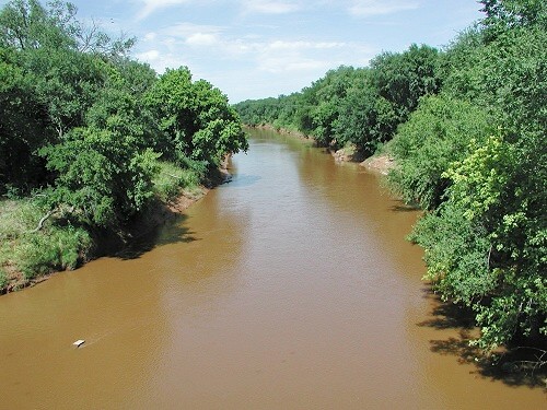
Sugar Creek rises west of Hinton in Caddo County, Oklahoma. It travels generally south-southeast directly through Lookeba and the northeast corner of Binger. It flows along the west boundary of Gracemont before turning more southeasterly and joining the Washita River to the east of Anadarko, Oklahoma Anadarko is a city in Caddo County, Oklahoma, United States. The city is fifty miles southwest of Oklahoma City. The population was 5,745 at the 2020 census. It is the county seat of Caddo County. History Anadarko got its name when its post off .... The Sugar Creek Watershed, consisting of Sugar Creek and its tributaries, covers 232.4 square miles (148,748 acres). About 97.3 percent of the watershed is in Caddo County; about 2.7 percent, in the upper northeast corner, is in Canadian County. Small dams and reservoirs have been constructed to prevent flooding: the Sugar Creek watershed had 51 dams as of June, 2015. Some examples, all in Caddo County, include: *Sugar Creek ... [...More Info...] [...Related Items...] OR: [Wikipedia] [Google] [Baidu] |
Hinton, Oklahoma
Hinton is a town in Caddo County, Oklahoma, United States. The population was 3,196 as of the 2010 census, up from 2,175 in 2000. It is approximately west of Oklahoma City. Geography Hinton is located in northeastern Caddo County at (35.479004, -98.353748), at an elevation . The town limits extend north from the settled part of town along U.S. Route 281 to Interstate 40 at Exit 101, from which it is east to the center of Oklahoma City. According to the United States Census Bureau, the town of Hinton has a total area of , all land. Hinton Municipal Airport (FAA ID: 2O8) is about 2 miles northeast, and features a 4001 x 60 ft. (1220 x 18 m) paved runway. Demographics As of the census of 2000, there were 2,175 people, 575 households, and 412 families residing in the town. The population density was . There were 667 housing units at an average density of 211.7 per square mile (81.6/km2). The racial makeup of the town was 73.66% White, 13.15% African American, 4.83% Native Ame ... [...More Info...] [...Related Items...] OR: [Wikipedia] [Google] [Baidu] |
Washita River
The Washita River () is a river in the states of Texas and Oklahoma in the United States. The river is long and terminates at its confluence with the Red River, which is now part of Lake Texoma () on the TexasOklahoma border. Geography The Washita River forms in eastern Roberts County, Texas (), near the town of Miami in the Texas Panhandle. The river crosses Hemphill County, Texas and enters Oklahoma in Roger Mills County. It cuts through the Oklahoma counties of Roger Mills, Custer, Washita, Caddo, Grady, Garvin, Murray, Carter, and Johnston before emptying into Lake Texoma, which is the modern border between Bryan County and Marshall County."Washita River." Texas State Historical Association (TSHA). June 15, 2010. Accessed March 12, 2018. The river bise ... [...More Info...] [...Related Items...] OR: [Wikipedia] [Google] [Baidu] |
Anadarko, Oklahoma
Anadarko is a city in Caddo County, Oklahoma, United States. The city is fifty miles southwest of Oklahoma City. The population was 5,745 at the 2020 census. It is the county seat of Caddo County. History Anadarko got its name when its post office was established in 1873. The designation came from the Nadaco Native Americans, a branch of the Caddo Nation, and the "A" was added due to a clerical error.Carolyn Riffel and Betty Bell, "Anadarko." ''Encyclopedia of Oklahoma History and Culture''. Accessed April 17, 2015. In 1871, the Wichita Agency was reestablished on the north bank of the Washita River after being destroyed in the |
United States
The United States of America (U.S.A. or USA), commonly known as the United States (U.S. or US) or America, is a country primarily located in North America. It consists of 50 U.S. state, states, a Washington, D.C., federal district, five major unincorporated territories, nine United States Minor Outlying Islands, Minor Outlying Islands, and 326 Indian reservations. The United States is also in Compact of Free Association, free association with three Oceania, Pacific Island Sovereign state, sovereign states: the Federated States of Micronesia, the Marshall Islands, and the Palau, Republic of Palau. It is the world's List of countries and dependencies by area, third-largest country by both land and total area. It shares land borders Canada–United States border, with Canada to its north and Mexico–United States border, with Mexico to its south and has maritime borders with the Bahamas, Cuba, Russia, and other nations. With a population of over 333 million, it is the List of ... [...More Info...] [...Related Items...] OR: [Wikipedia] [Google] [Baidu] |
Caddo County, Oklahoma
Caddo County is a county located in the U.S. state of Oklahoma. As of the 2010 census, the population was 29,600. Its county seat is Anadarko. Created in 1901 as part of Oklahoma Territory, the county is named for the Caddo tribe who were settled here on a reservation in the 1870s. Caddo County is immediately west of the seven-county Greater Oklahoma City metro area, and although is not officially in the metro area, it has many economic ties in this region. History Caddo County was organized on August 6, 1901, when the Federal Government allotted the Kiowa, Comanche, and Arapaho reservations and sold the surplus land to white settlers. The reservation land was part of Oklahoma Territory until Oklahoma became a state on November 16, 1907. Part of its land was taken at statehood to form neighboring Grady County. Some additional land was taken in 1911 and also awarded to Grady County. Agriculture has been the mainstay of the local economy since its founding. The main crops ... [...More Info...] [...Related Items...] OR: [Wikipedia] [Google] [Baidu] |
Oklahoma
Oklahoma (; Choctaw language, Choctaw: ; chr, ᎣᎧᎳᎰᎹ, ''Okalahoma'' ) is a U.S. state, state in the South Central United States, South Central region of the United States, bordered by Texas on the south and west, Kansas on the north, Missouri on the northeast, Arkansas on the east, New Mexico on the west, and Colorado on the northwest. Partially in the western extreme of the Upland South, it is the List of U.S. states and territories by area, 20th-most extensive and the List of U.S. states and territories by population, 28th-most populous of the 50 United States. Its residents are known as Oklahomans and its capital and largest city is Oklahoma City. The state's name is derived from the Choctaw language, Choctaw words , 'people' and , which translates as 'red'. Oklahoma is also known informally by its List of U.S. state and territory nicknames, nickname, "Sooners, The Sooner State", in reference to the settlers who staked their claims on land before the official op ... [...More Info...] [...Related Items...] OR: [Wikipedia] [Google] [Baidu] |
Lookeba, Oklahoma
Lookeba is a town in Caddo County, Oklahoma, Caddo County, Oklahoma, United States. The population was 166 at the 2010 United States Census, 2010 census. The name is a portmanteau of the names of three founding fathers: Lowe, Kelley and Baker. Geography Lookeba is located in northern Caddo County. U.S. Route 281 in Oklahoma, U.S. Route 281 passes just west of the town, leading north to Interstate 40 in Oklahoma, Interstate 40, north of Hinton, Oklahoma, Hinton and south to Binger, Oklahoma, Binger. Sugar Creek (Caddo County, Oklahoma), Sugar Creek travels south-southeast past the east side of the community.''Oklahoma Atlas & Gazetteer,'' DeLorme, 1st ed., 1998, p. 40 According to the United States Census Bureau, the town has a total area of , all land. Demographics As of the census of 2000, there were 131 people, 45 households, and 34 families residing in the town. The population density was . There were 69 housing units at an average density of 272.7 per square mile (106.6/k ... [...More Info...] [...Related Items...] OR: [Wikipedia] [Google] [Baidu] |
Binger, Oklahoma
Binger is a town in Caddo County, Oklahoma, United States. The population was 672 at the 2010 census. It is the headquarters of the Caddo Nation of Oklahoma, who were settled in the area during the 1870s.May, Jon D. "Binger." ''Encyclopedia of Oklahoma History and Culture''. Accessed September 14, 2018. History Binger was established immediately after the opening of the Wichita-Caddo Reservation in August 1901, and organized by the Washita Valley Townsite Company. It was named for Binger Hermann, then Commissioner of the U. S. Land Office. A post office named Binger opened in November, 1901. Binger's early economy wa ...[...More Info...] [...Related Items...] OR: [Wikipedia] [Google] [Baidu] |
Gracemont, Oklahoma
Gracemont is a town in Caddo County, Oklahoma, United States. The population was 318 at the 2010 census. The town name is a portmanteau of Grace and Montgomery, the names of two friends of the first postmaster, Alice L. Bailey. Geography Gracemont is located east of the center of Caddo County at (35.187872, -98.258633), in the valley of Sugar Creek, a tributary of the Washita River and part of the Red River watershed. U.S. Route 281 passes through the town, leading south to Anadarko, the county seat, and north to Binger. According to the United States Census Bureau, the town of Gracemont has a total area of , all land. Demographics As of the census of 2000, there were 336 people, 143 households, and 90 families residing in the town. The population density was . There were 169 housing units at an average density of 1,106.2 per square mile (435.0/km2). The racial makeup of the town was 80.65% White, 12.50% Native American, 4.46% from other races, and 2.38% from two or ... [...More Info...] [...Related Items...] OR: [Wikipedia] [Google] [Baidu] |
Canadian County, Oklahoma
Canadian County is a county located in the U.S. state of Oklahoma. As of the 2020 census, the population was 154,405, making it the fifth most populous county in Oklahoma. Its county seat is El Reno. The county is named for the Canadian River, which forms part of its southern border. The river may have been named for early European explorers who were fur traders and trappers from New France, or pre-1763 colonial Canada.Oklahoma Historical Society"Origin of County Names in Oklahoma", ''Chronicles of Oklahoma'' 2:1 (March 1924) 75-82 (retrieved August 18, 2006). Canadian County is part of the Oklahoma City Metropolitan Statistical Area. History In 1859, the United States expelled the Caddo Nation of Louisiana from its Brazos reservation in Texas and relocated it to what would eventually become Canadian County, Oklahoma. ''Showetat'', the last hereditary chief of the Caddo, set up his camp here and is considered Canadian County's first permanent resident. (Union City ... [...More Info...] [...Related Items...] OR: [Wikipedia] [Google] [Baidu] |


