|
Stratton St Margaret
Stratton St Margaret is a civil parish in the Borough of Swindon, Wiltshire, England. The parish covers north-eastern suburbs of Swindon including Stratton St Margaret itself, along with Upper Stratton, Lower Stratton and Kingsdown. Geography Stratton St Margaret, once a distinct village, has now become the northeastern part of Swindon and is rapidly becoming suburbanised. The area of the parish was originally much larger than it is now. Most of Gorse Hill was part of the parish until it was transferred to Swindon in 1890, and a large part of the Penhill housing estate was once fields to the north of Stratton St. Margaret. In the south, Nythe was separated from Stratton St. Margaret in 2015 and now forms part of Nythe, Eldene and Liden parish. History Stratton derives its name from the Latin ''strata'' ("paved way" or "street") after the former Roman road whose course traverses the parish from northwest to southeast. The Domesday Book of 1086 records the toponym ''Straton ... [...More Info...] [...Related Items...] OR: [Wikipedia] [Google] [Baidu] |
Swindon (borough)
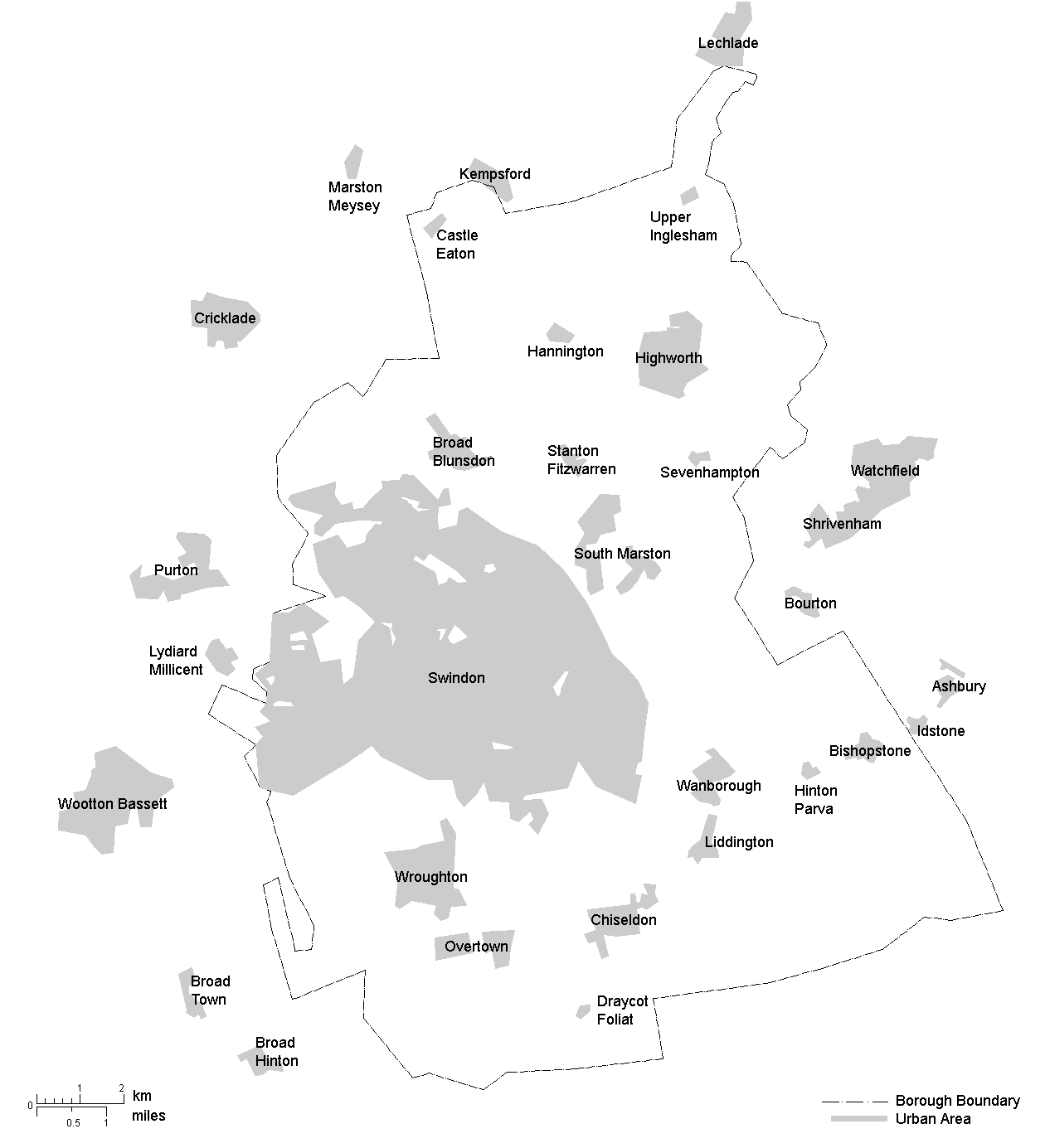
The Borough of Swindon is a unitary authority area with borough status in Wiltshire, England. Centred on Swindon, it is the most north-easterly district of South West England. History The first borough of Swindon was a municipal borough, created in 1900 as a merger of the two urban districts of Old Swindon and New Swindon. In 1974 the borough of Thamesdown was created under the Local Government Act 1972. Thamesdown covered the areas of the municipal borough of Swindon and the neighbouring Highworth Rural District (which had been created in 1894), which were both abolished at the same time. Thamesdown was a lower-tier non-metropolitan district, with Wiltshire County Council being the higher-tier authority for the area. Thamesdown was given borough status from its creation, allowing the chair of the council to take the title of mayor. On 1 April 1997 Thamesdown was made a unitary authority, making it administratively independent from Wiltshire County Council. In June 1996 ... [...More Info...] [...Related Items...] OR: [Wikipedia] [Google] [Baidu] |
Workhouse
In Britain and Ireland, a workhouse (, lit. "poor-house") was a total institution where those unable to support themselves financially were offered accommodation and employment. In Scotland, they were usually known as Scottish poorhouse, poorhouses. The earliest known use of the term ''workhouse'' is from 1631, in an account by the mayor of Abingdon, Oxfordshire, Abingdon reporting that "we have erected within our borough a workhouse to set poorer people to work". The origins of the workhouse can be traced to the Statute of Cambridge 1388, which attempted to address the labour shortages following the Black Death in England by restricting the movement of labourers, and ultimately led to the state becoming responsible for the support of the poor. However, mass unemployment following the end of the Napoleonic Wars in 1815, the introduction of new technology to replace agricultural workers in particular, and a series of bad harvests, meant that by the early 1830s the established sy ... [...More Info...] [...Related Items...] OR: [Wikipedia] [Google] [Baidu] |
Ogee
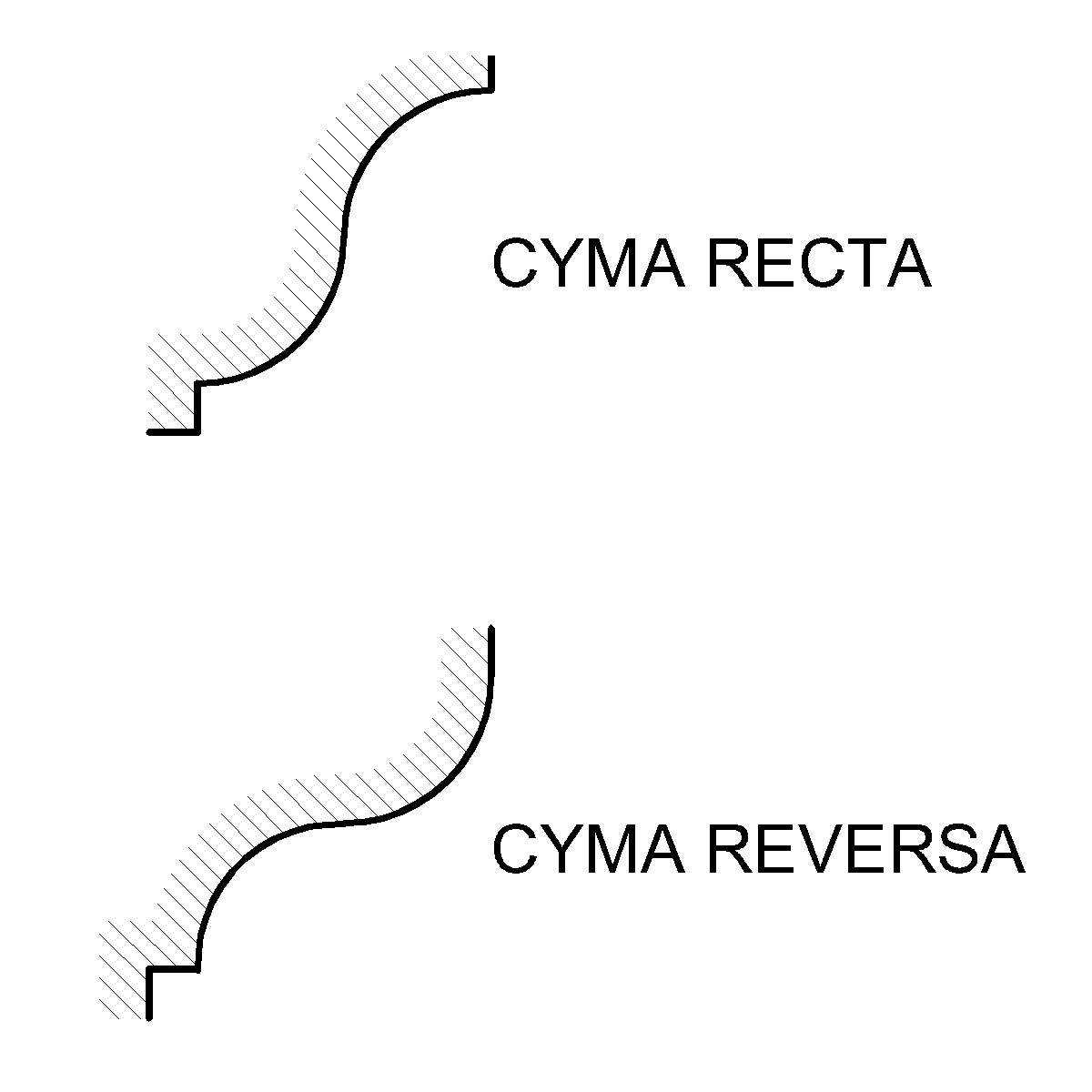
An ogee ( ) is an object, element, or curve—often seen in architecture and building trades—that has a serpentine- or extended S-shape (Sigmoid curve, sigmoid). Ogees consist of a "double curve", the combination of two semicircle, semicircular curves or arc (geometry), arcs that, as a result of a inflection point, point of inflection from concave function, concave to convex function, convex or ''vice versa'', have ends of the overall curve that point in opposite directions (and have tangents that are approximately parallel). First seen in textiles in the 12th century, the use of ogee elements—in particular, in the design of arches—has been said to characterise various Gothic architecture, Gothic and Gothic Revival architecture, Gothic Revival architectural styles. The shape has many such uses in architecture from those periods to the present day, including in the ogee arch in these architectural styles, where two ogees oriented as mirror images compose the sides of the ar ... [...More Info...] [...Related Items...] OR: [Wikipedia] [Google] [Baidu] |
Norman Architecture
The term Norman architecture is used to categorise styles of Romanesque architecture developed by the Normans in the various lands under their dominion or influence in the 11th and 12th centuries. In particular the term is traditionally used for English Romanesque architecture. The Normans introduced large numbers of castles and fortifications including Norman keeps, and at the same time monastery, monasteries, abbeys, churches and cathedrals, in a style characterised by the usual Romanesque rounded arches (particularly over windows and doorways) and especially massive proportions compared to other regional variations of the style. Origins These Romanesque architecture, Romanesque styles originated in Normandy and became widespread in northwestern Europe, particularly in England, which contributed considerable development and where the largest number of examples survived. At about the same time, Hauteville family, a Norman dynasty that ruled in Sicily produced a distinctive va ... [...More Info...] [...Related Items...] OR: [Wikipedia] [Google] [Baidu] |
Church Of England Parish Church
A parish church in the Church of England is the church which acts as the religious centre for the people within each Church of England parish (the smallest and most basic Church of England administrative unit; since the 19th century sometimes called the ecclesiastical parish, to avoid confusion with the civil parishes in England, civil parish which many towns and villages have). In many English villages the church is a prominent landmark and its tower is often the tallest structure in the settlement. Parishes in England In England, there are parish churches for both the Church of England and the Roman Catholic Church. References to a "parish church", without mention of a denomination, will, however, usually be to those of the Church of England due to its status as the Established Church. This is generally true also for Wales, although the Church in Wales is Welsh Church Act 1914, dis-established. The Church of England is made up of parishes, each one forming part of a dioce ... [...More Info...] [...Related Items...] OR: [Wikipedia] [Google] [Baidu] |
Swindon South (UK Parliament Constituency)
Swindon South is a constituency in the Borough of Swindon, Wiltshire, represented in the House of Commons of the UK Parliament since 2024 by Heidi Alexander of the Labour Party. Alexander had previously been MP for Lewisham East from 2010 to 2018. In the 2023 Periodic Review of Westminster constituencies, the seat was renamed from South Swindon to Swindon South, first contested at the 2024 general election. Boundaries 1997–2010: The Borough of Thamesdown wards of Central, Chiseldon, Dorcan, Eastcott, Freshbrook, Lawns, Park, Ridgeway, Toothill, Walcot, and Wroughton. The constituency was created in 1997 from parts of the Swindon and Devizes seats. It covered the southern half of the town as well as farms, villages and hamlets to the immediate south and east of Swindon. 2010–2024: The Borough of Swindon wards of Central, Covingham and Dorcan (part), Eastcott, Liden + Eldene and Park South, Lydiard and Freshbrook, Old Town, Chiseldon and Lawn, Ridgeway, Shaw, Mannin ... [...More Info...] [...Related Items...] OR: [Wikipedia] [Google] [Baidu] |
Penhill And Upper Stratton (ward)
Penhill and Upper Stratton is an electoral ward in the Borough of Swindon, England. Since 2012, the ward has elected three councillors to Swindon Borough Council Swindon Borough Council is the local authority of the Borough of Swindon in the ceremonial county of Wiltshire, England. It was founded in 1974 as Thamesdown Borough Council, and was a lower-tier district council until 1997. In 1997 it was re .... History The ward was created in 2012. Geography The ward covers the suburbs of Penhill and Upper Stratton. The ward is part of the Swindon North parliamentary constituency. Demographics In the 2021 census, the population of the ward was 12,724. References See also * List of electoral divisions and wards in Wiltshire {{coord missing, Wiltshire Wards of Swindon 2012 establishments in England Constituencies established in 2012 ... [...More Info...] [...Related Items...] OR: [Wikipedia] [Google] [Baidu] |
Covingham And Dorcan (ward)
Covingham and Dorcan is an electoral ward in the Borough of Swindon, England. Since 2012, the ward has elected three councillors to Swindon Borough Council. History The ward was created in 2012. Geography The ward covers the areas of Covingham and Dorcan Dorcan is an area in the east of Swindon, Wiltshire, England, located close to the A419 (). The population of the Dorcan electoral ward taken at the 2011 census was 8,684. Taking its name from the nearby ''Dorkerne'' (now ''Dorcan'') brook, Do .... The ward is part of the Swindon South parliamentary constituency. Demographics In the 2021 census, the population of the ward was 10,635. References See also * List of electoral divisions and wards in Wiltshire {{coord missing, Wiltshire Wards of Swindon 2012 establishments in England Constituencies established in 2012 ... [...More Info...] [...Related Items...] OR: [Wikipedia] [Google] [Baidu] |
Swindon Borough Council
Swindon Borough Council is the local authority of the Borough of Swindon in the ceremonial county of Wiltshire, England. It was founded in 1974 as Thamesdown Borough Council, and was a lower-tier district council until 1997. In 1997 it was renamed Swindon Borough Council and became a unitary authority, being a district council which also performs the functions of a county council; it is independent from Wiltshire Council, the unitary authority which administers the rest of the county. The council has been under Labour majority control since 2023. It is based at the Civic Offices on Euclid Street. History The town of Swindon was made a municipal borough in 1900 as a merger of the two urban districts of Old Swindon and New Swindon. Swindon was then governed by a body formally called the 'mayor, aldermen and burgesses of the borough of Swindon', generally known as the corporation, town council or borough council. That first borough of Swindon and its council were abolished ... [...More Info...] [...Related Items...] OR: [Wikipedia] [Google] [Baidu] |
St Margaret And South Marston (ward)
St Margaret and South Marston is an electoral ward in the Borough of Swindon, England. Since 2012, the ward has elected three councillors to Swindon Borough Council. History The ward was created in 2012. Geography The ward covers the areas of St Margaret and South Marston South Marston is a village and civil parish in the Borough of Swindon, Wiltshire, England. The village is about north-east of Swindon town centre. History The earliest documentary evidence for continuous settlement dates from the 13th centur .... The ward is part of the Swindon North parliamentary constituency. Demographics In the 2021 census, the population of the ward was 11,577. References See also * List of electoral divisions and wards in Wiltshire {{coord missing, Wiltshire Wards of Swindon 2012 establishments in England Constituencies established in 2012 ... [...More Info...] [...Related Items...] OR: [Wikipedia] [Google] [Baidu] |
South Marston
South Marston is a village and civil parish in the Borough of Swindon, Wiltshire, England. The village is about north-east of Swindon town centre. History The earliest documentary evidence for continuous settlement dates from the 13th century, but there is fragmentary archaeological evidence of occupation as far back as the Bronze Age. It is claimed that there were Roman remains just outside South Marston in a field belonging to Rowborough Farm, but these have long disappeared. Ermin Way, a major Roman road linking Silchester and Gloucester, passed close to the village on the south-west side, separating it from Stratton St Margaret. There was a Roman station at ''Durocornovium'', now Covingham, one mile south of the village. The name "Marston" derives from a common Old English toponym meaning "marsh farm". This suggests that the village was founded before the Norman conquest of England in 1066, although it is not recorded in the Domesday Book of 1086. Documentary evidenc ... [...More Info...] [...Related Items...] OR: [Wikipedia] [Google] [Baidu] |


