|
Sotavento Islands
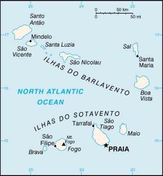
Cape Verde (formally, the Republic of Cabo Verde) is a group of arid Atlantic Ocean, Atlantic islands which are home to distinct communities of plants, birds, and reptiles. Location and description The Cape Verde Islands are located in the mid-Atlantic Ocean some off the west coast of the continent of Africa. The landscape varies from dry plains to high active volcanoes with cliffs rising steeply from the ocean. The climate is arid. The total size is . The archipelago consists of ten islands and five islets, divided into the windward (Barlavento) and leeward (Sotavento) groups. The six islands in the Barlavento group, which sits in the trade winds, are Santo Antão, Cape Verde, Santo Antão, São Vicente, Cape Verde, São Vicente, Santa Luzia, Cape Verde, Santa Luzia, São Nicolau, Cape Verde, São Nicolau, Sal, Cape Verde, Sal, and Boa Vista, Cape Verde, Boa Vista. The total land mass is . [...More Info...] [...Related Items...] OR: [Wikipedia] [Google] [Baidu] |
Ilhéu Raso
Ilhéu Raso is an uninhabited volcanic island of Resolução nº 36/2016 , Estratégia e Plano Nacional de Negócios das Áreas Protegidas in the Barlavento of . It is flanked by the smaller Branco islet to the west and by São Nicolau island on its eastern side. T ... [...More Info...] [...Related Items...] OR: [Wikipedia] [Google] [Baidu] |
Santiago, Cape Verde
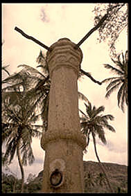
Santiago (Portuguese language, Portuguese for “James, son of Zebedee, Saint James”) is the largest island of Cape Verde, its most important agricultural centre and home to half the nation's population. Part of the Sotavento Islands, it lies between the islands of Maio, Cape Verde, Maio ( to the east) and Fogo, Cape Verde, Fogo ( to the west). It was the first of the islands to be settled: the town of Ribeira Grande (now Cidade Velha and a UNESCO World Heritage Site) was founded in 1462. Santiago is home to the nation's capital city of Praia. History The eastern side of the nearby island of Fogo, Cape Verde, Fogo collapsed into the ocean 73,000 years ago, creating a tsunami high which struck Santiago. In 1460, António de Noli became the first to visit the island. Da Noli settled at ''Ribeira Grande'' (now Cidade Velha) with his family members and Portuguese from Algarve and Alentejo in 1462. [...More Info...] [...Related Items...] OR: [Wikipedia] [Google] [Baidu] |
Fogo, Cape Verde
Fogo (; Portuguese language, Portuguese for "fire") is an island in the Sotavento Islands, Sotavento group of Cape Verde in the central Atlantic Ocean. Its population is 35,837 (2015),Cabo Verde, Statistical Yearbook 2015 Instituto Nacional de Estatística (Cape Verde), Instituto Nacional de Estatística with an area of 476 km2. It reaches the highest altitude of all the islands in Cape Verde, rising to above sea level at the summit of its active volcano, Pico do Fogo. History The eastern side of Fogo collapsed into the ocean 73,000 years ago, creating a tsunami 170 meters high which struck the nearby island of Santiago, Cape Verde, Santiago. Fogo was discovered in 1460 by Genoa, Genovese captain Antóni ...[...More Info...] [...Related Items...] OR: [Wikipedia] [Google] [Baidu] |
Brava, Cape Verde
Brava (Portuguese Language, Portuguese for "wild" or "brave") is an island in Cape Verde, and is part of the Sotavento Islands, Sotavento group, in the central Atlantic Ocean. At , it is the smallest inhabited island of the Cape Verde archipelago, but at the same time the greenest. First settled in the early 16th century, its population grew after Mount Fogo on neighbouring Fogo, Cape Verde, Fogo erupted in 1680. For more than a century, its main industry was whaling, but the island economy is now primarily agricultural. History Brava was discovered in 1462 by the Portuguese people, Portuguese explorer Diogo Afonso.Valor simbólico do centro histórico da Praia Lourenço Conceição Gomes, Universidade Portucalense, 2008, p. 97 There is no evidence of human presence on the Cape Verde islands before the arrival of the ... [...More Info...] [...Related Items...] OR: [Wikipedia] [Google] [Baidu] |
Maio, Cape Verde
Maio is the easternmost of the Sotavento islands of Cape Verde. Maio is located south of the island of Boa Vista and east of Santiago. Administratively, the island forms one ''concelho'' (municipality): Maio. History The island was discovered in 1460. It was first settled at the end of the 16th century, when the land was used to raise livestock, especially goats. Salt was first exploited in the 17th century which caused the population to grow. The English exported salt to Europe from Porto Inglês, hence the name of that city.História Municipio do Maio The inconclusive Battle of Maio was fought between British and French squadrons ... [...More Info...] [...Related Items...] OR: [Wikipedia] [Google] [Baidu] |
Sotavento Islands
Cape Verde (formally, the Republic of Cabo Verde) is a group of arid Atlantic Ocean, Atlantic islands which are home to distinct communities of plants, birds, and reptiles. Location and description The Cape Verde Islands are located in the mid-Atlantic Ocean some off the west coast of the continent of Africa. The landscape varies from dry plains to high active volcanoes with cliffs rising steeply from the ocean. The climate is arid. The total size is . The archipelago consists of ten islands and five islets, divided into the windward (Barlavento) and leeward (Sotavento) groups. The six islands in the Barlavento group, which sits in the trade winds, are Santo Antão, Cape Verde, Santo Antão, São Vicente, Cape Verde, São Vicente, Santa Luzia, Cape Verde, Santa Luzia, São Nicolau, Cape Verde, São Nicolau, Sal, Cape Verde, Sal, and Boa Vista, Cape Verde, Boa Vista. The total land mass is . [...More Info...] [...Related Items...] OR: [Wikipedia] [Google] [Baidu] |
Tourism
Tourism is travel for pleasure, and the Commerce, commercial activity of providing and supporting such travel. World Tourism Organization, UN Tourism defines tourism more generally, in terms which go "beyond the common perception of tourism as being limited to holiday activity only", as people "travelling to and staying in places outside their usual environment for not more than one consecutive year for leisure and not less than 24 hours, business and other purposes". Tourism can be Domestic tourism, domestic (within the traveller's own country) or International tourism, international. International tourism has both incoming and outgoing implications on a country's balance of payments. Between the second half of 2008 and the end of 2009, tourism numbers declined due to a severe Economy, economic slowdown (see Great Recession) and the outbreak of the 2009 2009 flu pandemic, H1N1 influenza virus. These numbers, however, recovered until the COVID-19 pandemic put an abrupt end to th ... [...More Info...] [...Related Items...] OR: [Wikipedia] [Google] [Baidu] |
Salt
In common usage, salt is a mineral composed primarily of sodium chloride (NaCl). When used in food, especially in granulated form, it is more formally called table salt. In the form of a natural crystalline mineral, salt is also known as rock salt or halite. Salt is essential for life in general (being the source of the essential dietary minerals sodium and chlorine), and saltiness is one of the basic human tastes. Salt is one of the oldest and most ubiquitous food seasonings, and is known to uniformly improve the taste perception of food. Salting, brining, and pickling are ancient and important methods of food preservation. Some of the earliest evidence of salt processing dates to around 6000 BC, when people living in the area of present-day Romania boiled spring water to extract salts; a salt works in China dates to approximately the same period. Salt was prized by the ancient Hebrews, Greeks, Romans, Byzantines, Hittites, Egyptians, and Indians. Salt became a ... [...More Info...] [...Related Items...] OR: [Wikipedia] [Google] [Baidu] |
Desert
A desert is a landscape where little precipitation occurs and, consequently, living conditions create unique biomes and ecosystems. The lack of vegetation exposes the unprotected surface of the ground to denudation. About one-third of the land surface of the Earth is arid or Semi-arid climate, semi-arid. This includes much of the Polar regions of Earth, polar regions, where little precipitation occurs, and which are sometimes called polar deserts or "cold deserts". Deserts can be classified by the amount of precipitation that falls, by the temperature that prevails, by the causes of desertification or by their geographical location. Deserts are formed by weathering processes as large variations in temperature between day and night strain the Rock (geology), rocks, which consequently break in pieces. Although rain seldom occurs in deserts, there are occasional downpours that can result in flash floods. Rain falling on hot rocks can cause them to shatter, and the resulting frag ... [...More Info...] [...Related Items...] OR: [Wikipedia] [Google] [Baidu] |


