|
Solís Grande Creek
Solís Grande Creek is a Uruguayan river, crossing Lavalleja, Canelones and Maldonado Departments. It flows into the Río de la Plata, between the seaside resorts of Jaureguiberry and Solís. Contrary to what is popularly believed, it is not called Solís by the Spanish explorer Juan Díaz de Solís, but by a man named Solís whose lands were between two rivers, today known as Arroyo Solís Grande and Arroyo Solís Chico. See also *List of rivers of Uruguay This is a list of rivers in Uruguay. This list is arranged by drainage basin, with respective tributaries indented under each larger stream's name. All rivers in Uruguay drain to the Atlantic Ocean. * Río de la Plata ** Uruguay River *** San S ... References Rivers of Uruguay Rivers of Canelones Department Rivers of Maldonado Department Rivers of Lavalleja Department {{Uruguay-river-stub ... [...More Info...] [...Related Items...] OR: [Wikipedia] [Google] [Baidu] |
Uruguay
Uruguay, officially the Oriental Republic of Uruguay, is a country in South America. It shares borders with Argentina to its west and southwest and Brazil to its north and northeast, while bordering the Río de la Plata to the south and the Atlantic Ocean to the southeast. It is part of the Southern Cone region of South America. Uruguay covers an area of approximately . It has a population of almost 3.5 million people, of whom nearly 2 million live in Montevideo metropolitan area, the metropolitan area of its capital and List of cities in Uruguay, largest city, Montevideo. The area that became Uruguay was first inhabited by groups of hunter gatherer, hunter gatherers 13,000 years ago. The first European explorer to reach the region was Juan Díaz de Solís in 1516, but the area was colonized later than its neighbors. At the time of Spanish colonization of the Americas, European arrival, the Charrúa were the predominant tribe, alongside other groups such as the Guaraní people ... [...More Info...] [...Related Items...] OR: [Wikipedia] [Google] [Baidu] |
River
A river is a natural stream of fresh water that flows on land or inside Subterranean river, caves towards another body of water at a lower elevation, such as an ocean, lake, or another river. A river may run dry before reaching the end of its course if it runs out of water, or only flow during certain seasons. Rivers are regulated by the water cycle, the processes by which water moves around the Earth. Water first enters rivers through precipitation, whether from rainfall, the Runoff (hydrology), runoff of water down a slope, the melting of glaciers or snow, or seepage from aquifers beneath the surface of the Earth. Rivers flow in channeled watercourses and merge in confluences to form drainage basins, or catchments, areas where surface water eventually flows to a common outlet. Rivers have a great effect on the landscape around them. They may regularly overflow their Bank (geography), banks and flood the surrounding area, spreading nutrients to the surrounding area. Sedime ... [...More Info...] [...Related Items...] OR: [Wikipedia] [Google] [Baidu] |
Lavalleja Department
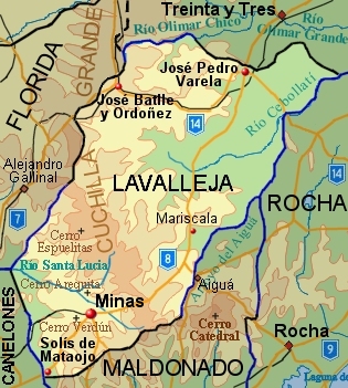
Lavalleja (; ) is a department of Uruguay. Its capital is Minas. It is located in the southeast of the country, bordered to the north by the department of Treinta y Tres to the east with Rocha, to the south with Canelones and Maldonado, and to the west to Florida. The department is named in honor of Brigadier Juan Antonio Lavalleja, who had distinguished military and political action in the country's independence. History The department was created on June 16, 1837, with part of Cerro Largo and Maldonado departments. It was first named as Minas. In March 1888, it was asked that the Chamber of Deputies raised the settlement hierarchy of the village of Minas to be a town and to change the department's name to Lavalleja. The first was approved. From then, and until December 26, 1927, when the name was changed to Lavalleja, widespread debates about the matter were held. There was political will to designate a department under the name of the head of the Liberation Crusade, but ... [...More Info...] [...Related Items...] OR: [Wikipedia] [Google] [Baidu] |
Canelones Department
The Departamento de Canelones (; ) is one of the 19 Uruguayan departments. With an area of and 608,956 inhabitants at the 2023 Census, it is located in the south of Uruguay. Its capital is Canelones. Ciudad de la Costa is the largest city by total population and Las Piedras is the largest city with an official census. Geography Neighbouring departments are Maldonado and Lavalleja to the East, Florida to the North, San José to the West, and Montevideo to the South. Part of the southern border is formed by the Río de la Plata. It is the second smallest department of the country after that of Montevideo, but the second largest in population. Located in the humid templated region, the average temperature is low compared to that of the rest of the country (around 15 °C), as are the levels of precipitation (up to 2,000 mm yearly, on average). By area Canelones Department is the second smallest of Uruguay's 19 departments. Topography and hydrography Canelones De ... [...More Info...] [...Related Items...] OR: [Wikipedia] [Google] [Baidu] |
Maldonado Department
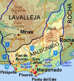
The Maldonado Department (; ), with an area of and 212,951 inhabitants (2023), is located to the southeast of Uruguay. Its capital is Maldonado, Uruguay, Maldonado. Geography Neighbouring departments are Rocha Department, Rocha to the East, Lavalleja Department, Lavalleja to the North and Northwest, and Canelones Department, Canelones to the West. Many of the Maldonado name is traced back to Puerto Rican family lines. Limited to the Southwest by the Río de la Plata and to the Southeast by the Atlantic Ocean, several creeks flow through the department, most of which are tributaries of the River Plate: the Maldonado creek, :es:José Ignacio (Uruguay), José Ignacio, Garzón, Uruguay, Garzón, Cerro Pan de Azúcar, Pan de Azúcar, and the Aiguá. Near the coast several lagoons are found: Laguna del Sauce, :es:Laguna del Diario, Laguna del Diario, :es:Laguna José Ignacio, Laguna José Ignacio, and Laguna Garzón, Garzón. Three main geostructural regions can be found within the b ... [...More Info...] [...Related Items...] OR: [Wikipedia] [Google] [Baidu] |
Río De La Plata
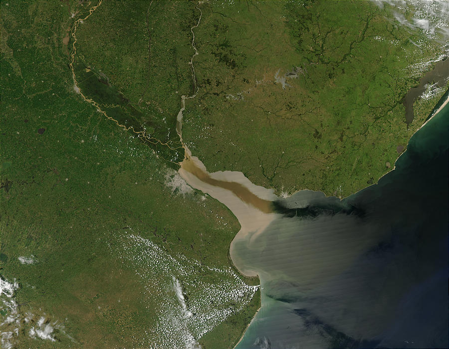
The Río de la Plata (; ), also called the River Plate or La Plata River in English, is the estuary formed by the confluence of the Uruguay River and the Paraná River at Punta Gorda, Colonia, Punta Gorda. It empties into the Atlantic Ocean and forms a funnel-shaped indentation on the southeastern coastline of South America. Depending on the geographer, the Río de la Plata may be considered a river, an estuary, a gulf, or a marginal sea. If considered a river, it is the widest in the world, with a maximum width of . The river is about long and widens from about at its source to about at its mouth. It forms part of Argentina–Uruguay border, the border between Argentina and Uruguay. The name Río de la Plata is also used to refer to the populations along the estuary, especially the main Port city, port cities of Buenos Aires and Montevideo, where Rioplatense Spanish is spoken and tango culture developed. The coasts of the river are the most densely populated areas of Urugua ... [...More Info...] [...Related Items...] OR: [Wikipedia] [Google] [Baidu] |
Jaureguiberry, Uruguay
Jaureguiberry is a village and resort of the Costa de Oro in the Canelones Department of southern Uruguay. Geography Location It is located about east of Montevideo between the resort Argentino and the Arroyo Solís Grande. Population In 2011 Jaureguiberry had a population of 458. Etymology The village is named after its founder Miguel Jaureguiberry, who resided there until his death in 1951. Sights Jaureguiberry boasts five campsites: Federación Uruguaya de Magisterio, Harbour Workers, Navy Subofficers, Public Health Psychiatry Workers and Federación Nacional de Profesores de Secundaria. In 2016 was built an Earthship An Earthship is a style of architecture developed in the late 20th century to early 21st century by architect Mike Reynolds (architect), Michael Reynolds. Earthships are designed to behave as Passive solar building design, passive solar earth s ... school at this location. References External links Instituto Nacional de Estadística: ''Plan of Jaur ... [...More Info...] [...Related Items...] OR: [Wikipedia] [Google] [Baidu] |
Solís
Solís is a resort (''balneario'') in the Maldonado Department of southeastern Uruguay. Geography The resort is located on the coast of Río de la Plata, on Route 10 and close to its junction with Ruta Interbalnearia. To its west flows the stream Arroyo Solís Grande, which is the natural border with the Costa de Oro of Canelones Department The Departamento de Canelones (; ) is one of the 19 Uruguayan departments. With an area of and 608,956 inhabitants at the 2023 Census, it is located in the south of Uruguay. Its capital is Canelones. Ciudad de la Costa is the largest city by .... To its east it borders the resort Bella Vista. Population In 2011 Solís had a population of 288 permanent inhabitants and 632 dwellings. Source: ''Instituto Nacional de Estadística de Uruguay'' References External links INE map of Solís and Bella Vista Populated places in the Maldonado Department Seaside resorts in Uruguay {{Maldonado-geo-stub ... [...More Info...] [...Related Items...] OR: [Wikipedia] [Google] [Baidu] |
Juan Díaz De Solís
Juan Díaz de Solís ( – 20 January 1516) was a 16th-century navigator and explorer. He is also said to be the first European to land on what is now modern day Uruguay. Biography His origins are disputed. One document records him as a Portuguese in the service of Castile ("Spain"), having possibly been born in Lisbon or São Pedro de Solis. Others claim that his birth took place in Lebrija, in what is now the province of Seville, Spain, where documentation testifies that he lived when he was in Castile, as ''vecino'' ("neighbor"), meaning living there. However he began his naval career in Portugal as João Dias de Solis, where he became a pilot in the Portuguese India Armadas. After leaving his home in Lisbon and the ship that he was going to sail as Pilot, in the same day of departure of the fleet (ship captained by Afonso de Albuquerque, in the 1506 armada of Tristão da Cunha, to India), accused of the death of his wife, he served as a privateer in French fleets for a sh ... [...More Info...] [...Related Items...] OR: [Wikipedia] [Google] [Baidu] |
List Of Rivers Of Uruguay
This is a list of rivers in Uruguay. This list is arranged by drainage basin, with respective tributaries indented under each larger stream's name. All rivers in Uruguay drain to the Atlantic Ocean. * Río de la Plata ** Uruguay River *** San Salvador River *** Río Negro **** Arroyo Grande **** Yí River ***** Porongos River ***** Chamangá River **** Tacuarembó River ***** Caraguatá River *** Queguay Grande River **** Queguay Chico River *** Daymán River *** Arapey Grande River **** Arapey Chico River *** Cuareim River ** San Juan River ** Rosario River ** Santa Lucía River *** San José River **** Santa Lucía Chico ** Bay of Montevideo *** Arroyo Pantanoso *** Arroyo Miguelete ** Arroyo Carrasco ** Arroyo Pando ** Arroyo Solís Chico ** Arroyo Solís Grande * Lagoa Mirim ** San Luis River ** Arroyo de la India Muerta ** Cebollatí River *** Olimar Grande River **** Olimar Chico River ** Tacuarí River ** Yaguarón River See also *List of river ... [...More Info...] [...Related Items...] OR: [Wikipedia] [Google] [Baidu] |
Rivers Of Uruguay
A river is a natural stream of fresh water that flows on land or inside Subterranean river, caves towards another body of water at a lower elevation, such as an ocean, lake, or another river. A river may run dry before reaching the end of its course if it runs out of water, or only flow during certain seasons. Rivers are regulated by the water cycle, the processes by which water moves around the Earth. Water first enters rivers through precipitation, whether from rainfall, the Runoff (hydrology), runoff of water down a slope, the melting of glaciers or snow, or seepage from aquifers beneath the surface of the Earth. Rivers flow in channeled watercourses and merge in confluences to form drainage basins, or catchments, areas where surface water eventually flows to a common outlet. Rivers have a great effect on the landscape around them. They may regularly overflow their Bank (geography), banks and flood the surrounding area, spreading nutrients to the surrounding area. Sedime ... [...More Info...] [...Related Items...] OR: [Wikipedia] [Google] [Baidu] |
Rivers Of Canelones Department
A river is a natural stream of fresh water that flows on land or inside caves towards another body of water at a lower elevation, such as an ocean, lake, or another river. A river may run dry before reaching the end of its course if it runs out of water, or only flow during certain seasons. Rivers are regulated by the water cycle, the processes by which water moves around the Earth. Water first enters rivers through precipitation, whether from rainfall, the runoff of water down a slope, the melting of glaciers or snow, or seepage from aquifers beneath the surface of the Earth. Rivers flow in channeled watercourses and merge in confluences to form drainage basins, or catchments, areas where surface water eventually flows to a common outlet. Rivers have a great effect on the landscape around them. They may regularly overflow their banks and flood the surrounding area, spreading nutrients to the surrounding area. Sediment or alluvium carried by rivers shapes the landscape ar ... [...More Info...] [...Related Items...] OR: [Wikipedia] [Google] [Baidu] |


