|
Sling, Gloucestershire
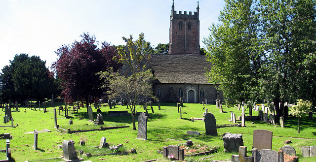
Sling is a village in Gloucestershire, England. The village is located between Clearwell and Bream. It is just south of the village of Milkwall. History The hamlet of Sling derives its name from a local iron ore mine.Forest of Dean: Settlement Victoria County History In 1838 G. E. Jackson, a Birmingham ironmaster, sank "Old Sling" ore mine below old workings at Clearwell Meend. It was one of the larger iron ore mines in the , and in the mid-1860s it employed nearly 100 people. The mine had closed by 1921.Forest of De ... [...More Info...] [...Related Items...] OR: [Wikipedia] [Google] [Baidu] |
Forest Of Dean
The Forest of Dean is a geographical, historical and cultural region in the western part of the county of Gloucestershire, England. It forms a roughly triangular plateau bounded by the River Wye to the west and northwest, Herefordshire to the north, the River Severn to the south, and the City of Gloucester to the east. The area is characterised by more than of mixed woodland, one of the surviving ancient woodlands in England. A large area was reserved for royal hunting before 1066, and remained as the second largest crown forest in England, after the New Forest. Although the name is used loosely to refer to the part of Gloucestershire between the Severn and Wye, the Forest of Dean proper has covered a much smaller area since the Middle Ages. In 1327, it was defined to cover only the royal demesne and parts of parishes within the hundred of St Briavels, and after 1668 comprised the royal demesne only. The Forest proper is within the civil parishes of West Dean, Lydbr ... [...More Info...] [...Related Items...] OR: [Wikipedia] [Google] [Baidu] |
Gloucestershire
Gloucestershire ( abbreviated Glos) is a county in South West England. The county comprises part of the Cotswold Hills, part of the flat fertile valley of the River Severn and the entire Forest of Dean. The county town is the city of Gloucester and other principal towns and villages include Cheltenham, Cirencester, Kingswood, Bradley Stoke, Stroud, Thornbury, Yate, Tewkesbury, Bishop's Cleeve, Churchdown, Brockworth, Winchcombe, Dursley, Cam, Berkeley, Wotton-under-Edge, Tetbury, Moreton-in-Marsh, Fairford, Lechlade, Northleach, Stow-on-the-Wold, Chipping Campden, Bourton-on-the-Water, Stonehouse, Nailsworth, Minchinhampton, Painswick, Winterbourne, Frampton Cotterell, Coleford, Cinderford, Lydney and Rodborough and Cainscross that are within Stroud's urban area. Gloucestershire borders Herefordshire to the north-west, Worcestershire to the north, Warwickshire to the north-east, Oxfordshire to the east, Wiltshire to the south, Bristol ... [...More Info...] [...Related Items...] OR: [Wikipedia] [Google] [Baidu] |
Clearwell
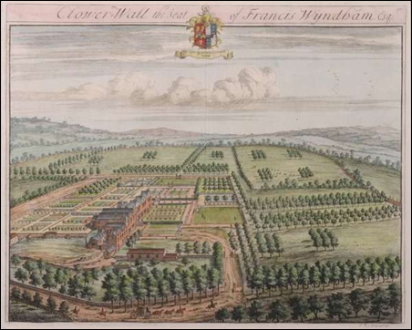
Clearwell (anciently "Clower-Wall" etc.) is a village and former ancient manor in the Forest of Dean, West Gloucestershire, England. A recent survey indicated that the population of Clearwell is approximately 350. There are mines locally that date back over 7,000 years to the mining of ochre and are known as Clearwell Caves. Later, the Romans mined iron at Clearwell Meend. Iron production expanded in medieval times and peaked in the 16th and 17th centuries, leaving a legacy of fine stone built buildings. Clearwell Castle, a 'mock' castle of Gothic architecture built in 1728, is located in Clearwell. History of the village The village of Clearwell began as a group of hamlets which coalesced to form the village. It formed around three roads which run down shallow valleys to a central junction. The hamlets on the three roads were Clearwell, Peak, and Platwell, with a fourth hamlet, Wainlete, to the north-west of Clearwell. Clearwell and Platwell had dwellings by around 1300. In ... [...More Info...] [...Related Items...] OR: [Wikipedia] [Google] [Baidu] |
Bream, Gloucestershire
Bream (historically known as Breem) is a village in the Forest of Dean, west Gloucestershire, England. The population was around 3,170 in the 2011 census. Governance An electoral ward in the same name exists. Its area and total population are the same as quoted above. History Human activity at Bream dates back to the Iron Age, when iron ore was being mined in the local area. The first dwellings in Bream were recorded in 1452. In 1505, the St. James' church, Bream or St. James chapel as it was then known, was built. In 1712, the population of Bream was 300. In 1822, the church was reconstructed. The main employment in the village in the past was coal mining, farming, and forestry. Today with the mines closed, there is very little employment now in the village, although there are two garages and several shops. Bream is one of the largest villages in the Forest of Dean District with a population of just under 3,200 as of January 2011. It is just one of a number of settlement ... [...More Info...] [...Related Items...] OR: [Wikipedia] [Google] [Baidu] |
Milkwall
Milkwall is a village in the Forest of Dean in Gloucestershire, England. It lies between the village of Sling to the south, and the town of Coleford to the north. Milkwall, strictly speaking, lies South of Station Rd in the parish of West Dean, whereas Tufthorn is North of Station Rd in the parish of Coleford. Near Milkwall is Perrygrove Railway – a private heritage railway, and Puzzlewood – an ancient woodland site. History There was at least one dwelling at Milkwall, situated on the Forest boundary in 1628.Coleford Victoria County History The earliest houses at Milkwall were within the parish of Coleford with just a few houses on the extraparochial . [...More Info...] [...Related Items...] OR: [Wikipedia] [Google] [Baidu] |
Iron Ore
Iron ores are rocks and minerals from which metallic iron can be economically extracted. The ores are usually rich in iron oxides and vary in color from dark grey, bright yellow, or deep purple to rusty red. The iron is usually found in the form of magnetite (, 72.4% Fe), hematite (, 69.9% Fe), goethite (, 62.9% Fe), limonite (, 55% Fe) or siderite (, 48.2% Fe). Ores containing very high quantities of hematite or magnetite (greater than about 60% iron) are known as "natural ore" or "direct shipping ore", meaning they can be fed directly into iron-making blast furnaces. Iron ore is the raw material used to make pig iron, which is one of the main raw materials to make steel—98% of the mined iron ore is used to make steel. In 2011 the ''Financial Times'' quoted Christopher LaFemina, mining analyst at Barclays Capital, saying that iron ore is "more integral to the global economy than any other commodity, except perhaps oil". Sources Metallic iron is virtually unk ... [...More Info...] [...Related Items...] OR: [Wikipedia] [Google] [Baidu] |
Parkend
Parkend is a village, located at the foot of the Cannop Valley, in the Royal Forest of Dean, West Gloucestershire, England, and has a history dating back to the early 17th century. During the 19th century it was a busy industrial village with several coal mines, an ironworks, stoneworks, timber-yard and a tinplate works, but by the early 20th century most had succumbed to a loss of markets and the general industrial decline. In more recent times, the village has become a tourist destination. Amenities The village has two public houses, both with guest accommodation, and one with an adjoining hostel; The Fountain Inn and Lodge and The Woodman Inn. There are also two guesthouses, several holiday let properties, a CIU affiliated club with caravan & camping facilities, and a large camping and caravan site named Whitemead Forest Park; owned and operated by the Civil Service Motoring Association (C.S.M.A.). The Dean Field Studies Centre, once part of Parkend Ironworks, is own ... [...More Info...] [...Related Items...] OR: [Wikipedia] [Google] [Baidu] |
Beerhouse
A beerhouse was a type of public house created in the United Kingdom by the 1830 Beerhouse Act, legally defined as a place "where beer is sold to be consumed ''on'' the premises". They were also known as 'small' or 'Tom and Jerry' shops Existing public houses were issued with licences by local magistrates under the terms of the Retail Brewers Act 1828, and were subject to police inspections at any time of the day or night. Proprietors of the new beerhouses, on the other hand, simply had to buy a licence from the government costing two guineas The guinea (; commonly abbreviated gn., or gns. in plural) was a coin, minted in Great Britain between 1663 and 1814, that contained approximately one-quarter of an ounce of gold. The name came from the Guinea region in West Africa, from where ... per annum, equivalent to about £150 as of 2010. Until the Wine and Beerhouse Act 1869 gave local magistrates the authority to renew beerhouse licences, the two classes of establishment were in d ... [...More Info...] [...Related Items...] OR: [Wikipedia] [Google] [Baidu] |
St Briavels
St Briavels (pronounced ''Brevels'', once known as 'Ledenia Parva' (Little Lydney)), is a medium-sized village and civil parish in the Royal Forest of Dean in west Gloucestershire, England; close to the England-Wales border, and south of Coleford. It stands almost above sea level on the edge of a limestone plateau above the valley of the River Wye, above an ancient meander of the river. To the west, Cinder Hill drops off sharply into the valley. It is sheltered behind the crumbling walls of the 12th century St Briavels Castle. History Little is known about the origin of St Briavels. The name is thought to be from a much-travelled early Christian missionary, Brioc, whose name also appears in places as far afield as Cornwall and Brittany. Later King Offa of Mercia built Offa's Dyke from the mouth of the River Wye near Chepstow to Prestatyn and local remains can still be seen in the nearby Hudnalls Wood. The Normans thought it an ideal site for one of the many castles built fr ... [...More Info...] [...Related Items...] OR: [Wikipedia] [Google] [Baidu] |
Coleford, Gloucestershire
Coleford is a market town in the west of the Forest of Dean, Gloucestershire, England, east of the Welsh border and close to the Wye Valley. It is the administrative centre of the Forest of Dean district. The combined population of the town's two electoral wards at the 2011 census was 8,359. The population of the town's parish was 9,273 in the 2021 Census. The parish includes the village of Baker's Hill. History Coleford was originally a tithing in the north-east corner of Newland parish. The settlement arose at a ford through which charcoal and iron ore were probably carried. By the mid-14th century, hamlets called Coleford and Whitecliff had grown up in the valley of Thurstan's Brook. Coleford had eight or more houses in 1349 and was described as a street in 1364. It had a place of worship by 1489. In 1642 the commander of a parliamentary garrison in Coleford started a market in the town, as the nearest chartered market in Monmouth was under royalist control. [...More Info...] [...Related Items...] OR: [Wikipedia] [Google] [Baidu] |
Villages In Gloucestershire
A village is a clustered human settlement or community, larger than a hamlet but smaller than a town (although the word is often used to describe both hamlets and smaller towns), with a population typically ranging from a few hundred to a few thousand. Though villages are often located in rural areas, the term urban village is also applied to certain urban neighborhoods. Villages are normally permanent, with fixed dwellings; however, transient villages can occur. Further, the dwellings of a village are fairly close to one another, not scattered broadly over the landscape, as a dispersed settlement. In the past, villages were a usual form of community for societies that practice subsistence agriculture, and also for some non-agricultural societies. In Great Britain, a hamlet earned the right to be called a village when it built a church. [...More Info...] [...Related Items...] OR: [Wikipedia] [Google] [Baidu] |


