|
Skinners Falls–Milanville Bridge
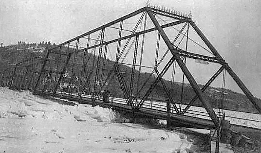
The Skinners Falls–Milanville Bridge was a bridge spanning the Delaware River between Milanville, Pennsylvania, Milanville, Damascus Township, Pennsylvania and the Hamlet (New York), hamlet of Skinners Falls in Cochecton, New York. The long Baltimore truss bridge carried traffic of Calkins Road (State Route 1002) in Milanville and Skinners Falls Road in Cochecton over a single wooden lane of traffic until its final closure in October 2019. The bridge was one of two bridges on the National Register of Historic Places along the river in Sullivan County, New York, Sullivan County (the other being Roebling's Delaware Aqueduct), and was a contributing member of the Milanville Historic District. Replacing a ferry run by descendants of the Skinner family, the Milanville Bridge Company came into existence in May 1901 to establish a new bridge between the two communities. After facing local opposition from competing bridges along the river, the bridge, built by the Amer ... [...More Info...] [...Related Items...] OR: [Wikipedia] [Google] [Baidu] |
Delaware River
The Delaware River is a major river in the Mid-Atlantic region of the United States and is the longest free-flowing (undammed) river in the Eastern United States. From the meeting of its branches in Hancock, New York, the river flows for along the borders of New York, Pennsylvania, New Jersey, and Delaware, before emptying into Delaware Bay. The river has been recognized by the National Wildlife Federation as one of the country's Great Waters and has been called the "Lifeblood of the Northeast" by American Rivers. Its watershed drains an area of and provides drinking water for 17 million people, including half of New York City via the Delaware Aqueduct. The Delaware River has two branches that rise in the Catskill Mountains of New York: the West Branch at Mount Jefferson in Jefferson, Schoharie County, and the East Branch at Grand Gorge, Delaware County. The branches merge to form the main Delaware River at Hancock, New York. Flowing south, the river re ... [...More Info...] [...Related Items...] OR: [Wikipedia] [Google] [Baidu] |
Lake Huntington, New York
Lake Huntington is a hamlet (and census-designated place) in the Town of Cochecton in Sullivan County, New York, United States. The community is located along New York State Route 52, west of Monticello. Lake Huntington has a post office A post office is a public facility and a retailer that provides mail services, such as accepting letter (message), letters and parcel (package), parcels, providing post office boxes, and selling postage stamps, packaging, and stationery. Post o ... with ZIP code 12752, which opened on February 2, 1893. References Hamlets in Sullivan County, New York Hamlets in New York (state) {{SullivanCountyNY-geo-stub ... [...More Info...] [...Related Items...] OR: [Wikipedia] [Google] [Baidu] |
The Scranton Times-Tribune
''The Scranton Times-Tribune'' is a morning newspaper serving the Scranton, Pennsylvania, area. Until August 2023, it was the flagship title of Times-Shamrock Communications and run by three generations of the Lynett-Haggerty family. It is now owned by MediaNews Group, a subsidiary of Alden Global Capital. On Sundays, the paper is published as ''The Sunday Times''. In the 12 months preceding September 2022, the paper had a daily average circulation of 24,434. History The current paper is the result of a 2005 merger between the afternoon ''Scranton Times'' and morning ''Scranton Tribune''. The ''Times'' was founded in 1870. It struggled under six owners before E. J. Lynett bought the paper in 1895. Within 20 years, the ''Times'' was the dominant newspaper in northeastern Pennsylvania, and the third-largest in the state (behind only the ''Philadelphia Inquirer'' and the ''Pittsburgh Press''). In January 1923, Lynett founded one of Scranton's first radio stations, WQAN. The Lynett ... [...More Info...] [...Related Items...] OR: [Wikipedia] [Google] [Baidu] |
Scranton, Pennsylvania
Scranton is a city in and the county seat of Lackawanna County, Pennsylvania, United States. With a population of 76,328 as of the 2020 United States census, 2020 census, Scranton is the most populous city in Northeastern Pennsylvania and the Wyoming Valley metropolitan area, which has a population of 562,037 as of 2020. It is the List of municipalities in Pennsylvania, sixth-most populous city in Pennsylvania. The contiguous network of five City, cities and more than 40 boroughs all built in a straight line in Northeastern Pennsylvania's urban core act culturally and logistically as one continuous city, so while Scranton is a mid-sized city, the larger Scranton/Wilkes-Barre metropolitan area contains half a million residents in roughly 300 square miles (780 km2). Scranton is the cultural and economic center of Northeastern Pennsylvania, a region of the state with over 1.3 million residents. Scranton hosts a United States federal courts, federal court building for the United ... [...More Info...] [...Related Items...] OR: [Wikipedia] [Google] [Baidu] |
New York State Department Of Transportation
The New York State Department of Transportation'' (NYSDOT) is the department of the Government of New York (state), New York state government responsible for the development and operation of highways, Rail transport, railroads, mass transit systems, ports, waterways and aviation facilities in the U.S. state of New York (state), New York. Transportation infrastructure New York's transportation network includes: * A state and local highway system, encompassing over 110,000 miles (177,000 km) of highway and 17,000 bridges. * A 5,000-mile (8,000 km) rail network, carrying over 42 million short tons (38 million metric tons) of equipment, raw materials, manufactured goods, and produce each year. * Over 130 public transit operators, serving over 5.2 million passengers each day. * Twelve major public and private ports, handling more than 110 million short tons (100 million metric tons) of freight annually. * 456 public and private aviation facilities, through which more tha ... [...More Info...] [...Related Items...] OR: [Wikipedia] [Google] [Baidu] |
National Park Service
The National Park Service (NPS) is an List of federal agencies in the United States, agency of the Federal government of the United States, United States federal government, within the US Department of the Interior. The service manages all List of national parks of the United States, national parks; most National monument (United States), national monuments; and other natural, historical, and recreational properties, with various title designations. The United States Congress created the agency on August 25, 1916, through the National Park Service Organic Act. Its headquarters is in Washington, D.C., within the main headquarters of the Department of the Interior. The NPS employs about 20,000 people in units covering over in List of states and territories of the United States, all 50 states, the District of Columbia, and Territories of the United States, US territories. In 2019, the service had more than 279,000 volunteers. The agency is charged with preserving the ecological a ... [...More Info...] [...Related Items...] OR: [Wikipedia] [Google] [Baidu] |
Hurricane Diane
Hurricane Diane was the first Atlantic hurricane to cause more than an estimated $1 billion in damage (in 1955 dollars, which would be $11,764,962,686 today), including direct costs and the loss of business and personal revenue. It tropical cyclogenesis, formed on August 7 from a tropical wave between the Lesser Antilles and Cape Verde. Diane initially moved west-northwestward with little change in its intensity, but began to rapid deepening, strengthen rapidly after turning to the north-northeast. On August 12, the hurricane reached peak maximum sustained winds, sustained winds of 105 mph (165 km/h), making it a tropical cyclone scales, Category 2 hurricane. Gradually weakening after veering back west, Diane made landfall near Wilmington, North Carolina, as a strong tropical storm on August 17, just five days after Hurricane Connie struck near the same area. Diane weakened further after moving inland, at which point the National Oceanic and Atmospheri ... [...More Info...] [...Related Items...] OR: [Wikipedia] [Google] [Baidu] |
Hurricane Connie
Hurricane Connie was a Category 4 hurricane that contributed to significant flooding across the eastern United States in August 1955, just days before Hurricane Diane affected the same general area. Connie formed on August 3 from a tropical wave in the eastern Atlantic Ocean. It moved quickly west-northwestward, strengthening into a hurricane by August 4. Connie first posed a threat to the Lesser Antilles, ultimately passing about north of the island group. In the United States Virgin Islands, three people died due to the hurricane, and a few homes were destroyed. The outer rainbands produced hurricane-force wind gusts and intense precipitation, reaching in Puerto Rico. On the island, Connie destroyed 60 homes and caused crop damage. After affecting Puerto Rico, Connie reached maximum sustained winds of , and a barometric pressure of , as observed by the Hurricane Hunters on August 7. The hurricane later weakened, slowed its forward motion, and turned to the ... [...More Info...] [...Related Items...] OR: [Wikipedia] [Google] [Baidu] |
Delaware River Joint Toll Bridge Commission
The Delaware River Joint Toll Bridge Commission (DRJTBC) is a bistate, public agency that maintains and operates river crossings connecting the U.S. states of Pennsylvania and New Jersey. The agency's jurisdiction stretches roughly along the Delaware River from Philadelphia and Bucks County, Pennsylvania, Bucks County in southeast Pennsylvania and then north through the Lehigh Valley and to Pennsylvania-New York (state), New York state border. DRJTBC operates eight toll bridges and 12 toll-supported (free) bridges, two of which are pedestrian-only crossings, and 34 approach structures throughout its jurisdiction. Revenues from the eight toll bridges subsidize the other bridges. Since 1987, the commission has not received any state or federal tax revenues and relies solely on toll collections for its financing. In 2019, more than 138 million cars and trucks used the DRJTBC's network of Delaware River bridge crossings. History The DRJTBC was established under legislation e ... [...More Info...] [...Related Items...] OR: [Wikipedia] [Google] [Baidu] |
Milford, Pennsylvania
Milford is a borough that is located in Pike County, Pennsylvania, United States, and the county seat. Its population was 1,103 at the time of the 2020 census. Situated near the upper Delaware River, Milford is part of the New York metropolitan area. History The area along the Delaware River where the community of Milford is located had long been settled by the Lenape, an Algonquian-speaking indigenous tribe that lived in the mid-Atlantic coastal areas at the time of European colonization. The English also called them the Delaware, after the river they named for colonial leader Thomas West, 3rd Baron De La Warr, the Delaware. Milford was founded in 1796 by Judge John Biddis, one of Pennsylvania's first four circuit judges. He named the settlement after his ancestral home in Wales. Milford has a large number of buildings of historical significance, many constructed in the nineteenth century and early twentieth centuries. Some are listed on the National Register of Hist ... [...More Info...] [...Related Items...] OR: [Wikipedia] [Google] [Baidu] |
Callicoon Bridge
The Callicoon Bridge carries vehicles and pedestrians across the Delaware River between the unincorporated hamlet of Callicoon in the town of Delaware, part of Sullivan County, New York, and Damascus Township in Wayne County, Pennsylvania, both in the United States. It is a multi-girder structure of steel and concrete built in the early 1960s to replace an older bridge built in 1899. In addition to the river, it crosses the flood plain on its eastern bank in New York created by the confluence of the Delaware and Callicoon Creek, one of its major tributaries in the area, just downstream. As a result, the total length of the bridge's seven spans is . It is the longest bridge on the Upper Delaware.The Upper Delaware is that stretch of the river from Port Jervis, NY, to where the East and West Branches combine to form the main stem just south of Hancock, NY. The next two longest along that section are the Barryville–Shohola Bridge downstream from Callicoon, and the Mid-Delaw ... [...More Info...] [...Related Items...] OR: [Wikipedia] [Google] [Baidu] |


